2023 Edition
CIA World Factbook 2023 (factbook.json @ 0d4fa4984ecb)
Introduction
Background
The island of Timor was actively involved in Southeast Asian trading networks for centuries, and by the 14th century exported aromatic sandalwood, slaves, honey, and wax. A number of local chiefdoms ruled the island in the early 16th century when Portuguese traders arrived, chiefly attracted by the relative abundance of sandalwood on Timor; by mid-century, the Portuguese had colonized the island. Skirmishing with the Dutch in the region eventually resulted in an 1859 treaty in which Portugal ceded the western portion of the island. Imperial Japan occupied Portuguese Timor from 1942 to 1945, but Portugal resumed colonial authority after the Japanese defeat in World War II. East Timor declared itself independent from Portugal on 28 November 1975 and was invaded and occupied by Indonesian forces nine days later. It was incorporated into Indonesia in July 1976 as the province of Timor Timur (East Timor or Timor Leste). An unsuccessful campaign of pacification followed over the next two decades, during which an estimated 100,000 to 250,000 people died. In an August 1999 UN-supervised popular referendum, an overwhelming majority of the people of Timor-Leste voted for independence from Indonesia. However, in the next three weeks, anti-independence Timorese militias - organized and supported by the Indonesian military - commenced a large-scale, scorched-earth campaign of retribution. The militias killed approximately 1,400 Timorese and displaced nearly 500,000. Most of the country's infrastructure, including homes, irrigation systems, water supply systems, and schools, and nearly all of the country's electrical grid were destroyed. On 20 September 1999, Australian-led peacekeeping troops deployed to the country and brought the violence to an end. On 20 May 2002, Timor-Leste was internationally recognized as an independent state. In 2006, internal tensions threatened the new nation's security when a military strike led to violence and a breakdown of law and order. At Dili's request, an Australian-led International Stabilization Force (ISF) deployed to Timor-Leste, and the UN Security Council established the UN Integrated Mission in Timor-Leste (UNMIT), which included an authorized police presence of over 1,600 personnel. The ISF and UNMIT restored stability, allowing for presidential and parliamentary elections in 2007 in a largely peaceful atmosphere. In 2008, rebels staged an unsuccessful attack against the president and prime minister. Since the attack, Timor-Leste has made considerable progress in building stability and democratic institutions, holding a series of successful parliamentary and presidential elections since 2012. Nonetheless, weak and unstable political coalitions have led to periodic episodes of political stalemate and crisis in governance. The ISF and UNMIT departed in 2012 but the UN continues to provide assistance on economic development and strengthening governing institutions. Currently, Timor-Leste is one of the world's poorest nations with an economy that relies heavily on energy resources in the Timor Sea.
Geography
Area
- land
- 14,874 sq km
- total
- 14,874 sq km
- water
- 0 sq km
Area - comparative
slightly larger than Connecticut; almost half the size of Maryland
Climate
tropical; hot, humid; distinct rainy and dry seasons
Coastline
706 km
Elevation
- highest point
- Foho Tatamailau 2,963 m
- lowest point
- Timor Sea, Savu Sea, and Banda Sea 0 m
Geographic coordinates
8 50 S, 125 55 E
Geography - note
Timor comes from the Malay word for "east"; the island of Timor is part of the Malay Archipelago and is the largest and easternmost of the Lesser Sunda Islands; the district of Oecussi is an exclave separated from Timor-Leste proper by Indonesia; Timor-Leste has the unique distinction of being the only Asian country located completely in the Southern Hemisphere
Irrigated land
350 sq km (2012)
Land boundaries
- border countries
- Indonesia 253 km
- total
- 253 km
Land use
- agricultural land
- 25.1% (2018 est.)
- agricultural land: arable land
- arable land: 10.1% (2018 est.)
- agricultural land: permanent crops
- permanent crops: 4.9% (2018 est.)
- agricultural land: permanent pasture
- permanent pasture: 10.1% (2018 est.)
- forest
- 49.1% (2018 est.)
- other
- 25.8% (2018 est.)
Location
Southeastern Asia, northwest of Australia in the Lesser Sunda Islands at the eastern end of the Indonesian archipelago; note - Timor-Leste includes the eastern half of the island of Timor, the Oecussi (Ambeno) region on the northwest portion of the island of Timor, and the islands of Pulau Atauro and Pulau Jaco
Map references
Southeast Asia
Maritime claims
- contiguous zone
- 24 nm
- exclusive fishing zone
- 200 nm
- territorial sea
- 12 nm
Natural hazards
floods and landslides are common; earthquakes; tsunamis; tropical cyclones
Natural resources
gold, petroleum, natural gas, manganese, marble
Population distribution
most of the population concentrated in the western third of the country, particularly around Dili
Terrain
mountainous
People and Society
Age structure
- 0-14 years
- 39.05% (male 296,331/female 280,029)
- 15-64 years
- 56.61% (male 408,662/female 426,897)
- 65 years and over
- 4.34% (2023 est.) (male 30,856/female 33,267)
Alcohol consumption per capita
- beer
- 0.27 liters of pure alcohol (2019 est.)
- other alcohols
- 0 liters of pure alcohol (2019 est.)
- spirits
- 0.05 liters of pure alcohol (2019 est.)
- total
- 0.41 liters of pure alcohol (2019 est.)
- wine
- 0.09 liters of pure alcohol (2019 est.)
Birth rate
30.4 births/1,000 population (2023 est.)
Child marriage
- men married by age 18
- 1.2% (2016 est.)
- women married by age 15
- 2.6%
- women married by age 18
- 14.9%
Children under the age of 5 years underweight
31.9% (2020)
Contraceptive prevalence rate
26.1% (2016)
Current health expenditure
9.9% of GDP (2020)
Currently married women (ages 15-49)
55.9% (2023 est.)
Death rate
5.6 deaths/1,000 population (2023 est.)
Demographic profile
Timor-Leste’s high fertility and population growth rates sustain its very youthful age structure – approximately 40% of the population is below the age of 15 and the country’s median age is 20. While Timor-Leste’s total fertility rate (TFR) – the average number of births per woman – decreased significantly from over 7 in the early 2000s, it remains high at 4.3 in 2021 and will probably continue to decline slowly. The low use of contraceptives and the traditional preference for large families is keeping fertility elevated. The high TFR and falling mortality rates continue to fuel a high population growth rate of nearly 2.2%, which is the highest in Southeast Asia. The country’s high total dependency ratio – a measure of the ratio of dependents to the working-age population – could divert more government spending toward social programs. Timor-Leste’s growing, poorly educated working-age population and insufficient job creation are ongoing problems. Some 70% of the population lives in rural areas, where most of people are dependent on the agricultural sector. Malnutrition and poverty are prevalent, with 42% of the population living under the poverty line as of 2014. During the Indonesian occupation (1975-1999) and Timor-Leste’s fight for independence, approximately 250,000 Timorese fled to western Timor and, in lesser numbers, Australia, Portugal, and other countries. Many of these emigrants later returned. Since Timor-Leste’s 1999 independence referendum, economic motives and periods of conflict have been the main drivers of emigration. Bilateral labor agreements with Australia, Malaysia, and South Korea and the presence of Timorese populations abroad, are pull factors, but the high cost prevents many young Timorese from emigrating. Timorese communities are found in its former colonizers, Indonesia and Portugal, as well as the Philippines and the UK. The country has also become a destination for migrants in the surrounding region, mainly men seeking work in construction, commerce, and services in Dili.
Dependency ratios
- elderly dependency ratio
- 8.9
- potential support ratio
- 11.2 (2021 est.)
- total dependency ratio
- 90.3
- youth dependency ratio
- 59.4
Drinking water source
- improved: rural
- rural: 82.5% of population
- improved: total
- total: 87.4% of population
- improved: urban
- urban: 98% of population
- unimproved: rural
- rural: 17.5% of population
- unimproved: total
- total: 12.6% of population (2020 est.)
- unimproved: urban
- urban: 2% of population
Education expenditures
4.2% of GDP (2020 est.)
Ethnic groups
Austronesian (Malayo-Polynesian) (includes Tetun, Mambai, Tokodede, Galoli, Kemak, Baikeno), Melanesian-Papuan (includes Bunak, Fataluku, Bakasai), small Chinese minority
Gross reproduction rate
1.98 (2023 est.)
Infant mortality rate
- female
- 29.5 deaths/1,000 live births
- male
- 36.1 deaths/1,000 live births
- total
- 32.9 deaths/1,000 live births (2023 est.)
Languages
- Tetun Prasa 30.6%, Mambai 16.6%, Makasai 10.5%, Tetun Terik 6.1%, Baikenu 5.9%, Kemak 5.8%, Bunak 5.5%, Tokodede 4%, Fataluku 3.5%, Waima'a 1.8%, Galoli 1.4%, Naueti 1.4%, Idate 1.2%, Midiki 1.2%, other 4.5% (2015 est.)
- note
- note: data represent population by mother tongue; Tetun and Portuguese are official languages; Indonesian and English are working languages; there are about 32 indigenous languages
Life expectancy at birth
- female
- 72 years
- male
- 68.6 years
- total population
- 70.2 years (2023 est.)
Literacy
- definition
- age 15 and over can read and write
- female
- 64.2% (2018)
- male
- 71.9%
- total population
- 68.1%
Major infectious diseases
- degree of risk
- very high (2023)
- food or waterborne diseases
- bacterial diarrhea, hepatitis A, and typhoid fever
- vectorborne diseases
- dengue fever and malaria
Major urban areas - population
281,000 DILI (capital) (2018)
Maternal mortality ratio
204 deaths/100,000 live births (2020 est.)
Median age
- female
- 21.1 years
- male
- 19.6 years
- total
- 20.3 years (2023 est.)
Mother's mean age at first birth
- 23 years (2016 est.)
- note
- note: data represents median age at first birth among women 25-49
Nationality
- adjective
- Timorese
- noun
- Timorese
Net migration rate
-3.8 migrant(s)/1,000 population (2023 est.)
Obesity - adult prevalence rate
3.8% (2016)
People - note
one of only two predominantly Christian nations in Southeast Asia, the other being the Philippines
Physicians density
0.76 physicians/1,000 population (2020)
Population
1,476,042 (2023 est.)
Population distribution
most of the population concentrated in the western third of the country, particularly around Dili
Population growth rate
2.1% (2023 est.)
Religions
Roman Catholic 97.6%, Protestant/Evangelical 2%, Muslim 0.2%, other 0.2% (2015 est.)
Sanitation facility access
- improved: rural
- rural: 56.1% of population
- improved: total
- total: 66.3% of population
- improved: urban
- urban: 88.7% of population
- unimproved: rural
- rural: 43.9% of population
- unimproved: total
- total: 33.7% of population (2020 est.)
- unimproved: urban
- urban: 11.3% of population
Sex ratio
- 0-14 years
- 1.06 male(s)/female
- 15-64 years
- 0.96 male(s)/female
- 65 years and over
- 0.93 male(s)/female
- at birth
- 1.07 male(s)/female
- total population
- 0.99 male(s)/female (2023 est.)
Tobacco use
- female
- 10.8% (2020 est.)
- male
- 67.6% (2020 est.)
- total
- 39.2% (2020 est.)
Total fertility rate
4.09 children born/woman (2023 est.)
Urbanization
- rate of urbanization
- 3.31% annual rate of change (2020-25 est.)
- urban population
- 32.5% of total population (2023)
Youth unemployment rate (ages 15-24)
- female
- 16.8%
- male
- 11.4%
- total
- 13.8% (2021 est.)
Government
Administrative divisions
- 12 municipalities (municipios, singular municipio) and 1 special adminstrative region* (regiao administrativa especial); Aileu, Ainaro, Baucau, Bobonaro (Maliana), Covalima (Suai), Dili, Ermera (Gleno), Lautem (Lospalos), Liquica, Manatuto, Manufahi (Same), Oe-Cusse Ambeno* (Pante Macassar), Viqueque
- note
- note: administrative divisions have the same names as their administrative centers (exceptions have the administrative center name following in parentheses)
Capital
- geographic coordinates
- 8 35 S, 125 36 E
- name
- Dili
- time difference
- UTC+9 (14 hours ahead of Washington, DC, during Standard Time)
Citizenship
- citizenship by birth
- no
- citizenship by descent only
- at least one parent must be a citizen of Timor-Leste
- dual citizenship recognized
- no
- residency requirement for naturalization
- 10 years
Constitution
- amendments
- proposed by Parliament and parliamentary groups; consideration of amendments requires at least four-fifths majority approval by Parliament; passage requires two-thirds majority vote by Parliament and promulgation by the president of the republic; passage of amendments to the republican form of government and the flag requires approval in a referendum
- history
- drafted 2001, approved 22 March 2002, entered into force 20 May 2002
Country name
- conventional long form
- Democratic Republic of Timor-Leste
- conventional short form
- Timor-Leste
- etymology
- timor" derives from the Indonesian and Malay word "timur" meaning "east"; "leste" is the Portuguese word for "east", so "Timor-Leste" literally means "Eastern-East"; the local [Tetum] name "Timor Lorosa'e" translates as "East Rising Sun"
- former
- East Timor, Portuguese Timor
- local long form
- Republika Demokratika Timor Lorosa'e (Tetum)/ Republica Democratica de Timor-Leste (Portuguese)
- local short form
- Timor Lorosa'e (Tetum)/ Timor-Leste (Portuguese)
- note
- note: pronounced TEE-mor LESS-tay
Diplomatic representation from the US
- chief of mission
- Ambassador (vacant), Chargé d'Affaires Marc WEINSTOCK (since August 2023)
- email address and website
- ConsDili@state.govhttps://tl.usembassy.gov/
- embassy
- Avenida de Portugal, Praia dos Coqueiros, Dili
- FAX
- (670) 331-3206
- mailing address
- 8250 Dili Place, Washington, DC 20521-8250
- telephone
- (670) 332-4684, (670) 330-2400
Diplomatic representation in the US
- chancery
- 4201 Connecticut Avenue NW, Suite 504, Washington, DC 20008
- chief of mission
- Ambassador (vacant); Chargé d’Affaires Antonito DE ARAUJO (since 24 February 2023)
- email address and website
- info@timorlesteembassy.orghttp://www.timorlesteembassy.org/
- FAX
- [1] (202) 966-3205
- telephone
- [1] (202) 966-3202
Executive branch
- cabinet
- Council of Ministers; ministers proposed to the prime minister by the coalition in the Parliament and sworn in by the President of the Republic
- chief of state
- President José RAMOS-HORTA (since May 2022); note - the president is commander in chief of the military and can veto legislation, dissolve parliament, and call national elections
- election results
- 2022: José RAMOS-HORTA elected president in a runoff - RAMOS-HORTA (CNRT) 62.1%, Francisco GUTERRES (FRETILIN) 37.9%2017: Francisco GUTERRES (FRETILIN) 57.1%, António da CONCEICAO (PD) 32.46%
- elections/appointments
- president directly elected by absolute majority popular vote in 2 rounds if needed for a 5-year term (eligible for a second term); last election held in April 2022 (next election to be held April 2027); following parliamentary elections, the president appoints the leader of the majority party or majority coalition as the prime minister
- head of government
- Prime Minister Kay Rala Xanana GUSMAO (since 1 July 2023)
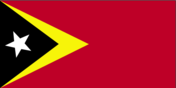
Flag description
red with a black isosceles triangle (based on the hoist side) superimposed on a slightly longer yellow arrowhead that extends to the center of the flag; a white star - pointing to the upper hoist-side corner of the flag - is in the center of the black triangle; yellow denotes the colonialism in Timor-Leste's past, black represents the obscurantism that needs to be overcome, red stands for the national liberation struggle; the white star symbolizes peace and serves as a guiding light
Government type
semi-presidential republic
Independence
20 May 2002 (from Indonesia); note - 28 November 1975 was the date independence was proclaimed from Portugal; 20 May 2002 was the date of international recognition of Timor-Leste's independence from Indonesia
International law organization participation
accepts compulsory ICJ jurisdiction with reservations; accepts ICCt jurisdiction
International organization participation
ACP, ADB, AOSIS, ARF, ASEAN (observer), CPLP, EITI (compliant country), FAO, G-77, IBRD, ICAO, ICCt, ICRM, IDA, IFAD, IFC, IFRCS, ILO, IMF, IMO, Interpol, IOC, IOM, IPU, ITU, MIGA, NAM, OPCW, PIF (observer), UN, UNCTAD, UNESCO, UNIDO, Union Latina, UNWTO, UPU, WCO, WHO, WMO
Judicial branch
- highest court(s)
- Court of Appeals (consists of the court president and NA judges)
- judge selection and term of office
- court president appointed by the president of the republic from among the other court judges to serve a 4-year term; other court judges appointed - 1 by the Parliament and the others by the Supreme Council for the Judiciary, a body chaired by the court president and that includes mostly presidential and parliamentary appointees; other judges serve for life
- note
- note: the UN Justice System Programme, launched in 2003 and being rolled out in 4 phases through 2018, is helping strengthen the country's justice system; the Programme is aligned with the country's long-range Justice Sector Strategic Plan, which includes legal reforms
- subordinate courts
- Court of Appeal; High Administrative, Tax, and Audit Court; district courts; magistrates' courts; military courts
Legal system
civil law system based on the Portuguese model; note - penal and civil law codes to replace the Indonesian codes were passed by Parliament and promulgated in 2009 and 2011, respectively
Legislative branch
- description
- unicameral National Parliament (65 seats; members directly elected in a single nationwide constituency by closed, party-list proportional representation vote using the D'Hondt method to serve 5-year terms)
- election results
- percent of vote by party in 2023 elections - CNRT 41.5%, FRETILIN 25.8%, PD 9.3%, KHUNTO 7.5%, PLP 6%, other 9.9%; seats by party - CNRT 31, FRETILIN 19, PD 6, KHUNTO 5, PLP 4; note - 12 other parties received votes, but won no seatspercent of vote by party in 2018 elections - AMP 49.6%, FRETILIN 34.2%, PD 8.1%, DDF 5.5%, other 2.6%; seats by party - AMP 34, FRETILIN 23, PD 5, DDF 3; composition - men 39, women 26, percent of women 40%; note - AMP (Alliance for Change and Progress) was a coalition of CNRT, PLP, and KHUNTO which dissolved in May of 2020
- elections
- last held May 2023 (next to be held in May 2028)
National anthem
- lyrics/music
- Fransisco Borja DA COSTA/Afonso DE ARAUJO
- name
- "Patria" (Fatherland)
- note
- note: adopted 2002; the song was first used as an anthem when Timor-Leste declared its independence from Portugal in 1975; the lyricist, Francisco Borja DA COSTA, was killed in the Indonesian invasion just days after independence was declared
National holiday
Restoration of Independence Day, 20 May (2002); Proclamation of Independence Day, 28 November (1975)
National symbol(s)
Mount Ramelau; national colors: red, yellow, black, white
Political parties and leaders
- Democratic Party or PD [Mariano Assanami SABINO Lopes]National Congress for Timorese Reconstruction or CNRT [Kay Rala Xanana GUSMAO]National Unity of the Sons of Timor (Haburas Unidade Nasional Timor Oan or KHUNTO) [Armanda BERTA DOS SANTOS]People's Liberation Party or PLP [Taur Matan RUAK]Revolutionary Front of Independent Timor-Leste or FRETILIN [Franciso GUTERRES]
- note
- note: 12 additional parties received votes during the 2023 parliamentary election but did not gain any seats
Suffrage
17 years of age; universal
Economy
Agricultural products
rice, maize, vegetables, coffee, roots/tubers nes, other meats, cassava, pork, beans, mangoes/guavas
Budget
- expenditures
- $1.396 billion (2019 est.)
- revenues
- $879 million (2019 est.)
Budget surplus (+) or deficit (-)
-75.7% (of GDP) (2017 est.)
Current account balance
- Current account balance 2019
- $133.98 million (2019 est.)
- Current account balance 2020
- -$308.02 million (2020 est.)
- Current account balance 2021
- $1.022 billion (2021 est.)
Debt - external
- Debt - external 31 December 2013
- $687 million (31 December 2013 est.)
- Debt - external 31 December 2014
- $311.5 million (31 December 2014 est.)
Economic overview
lower middle-income Southeast Asian economy; government expenditures funded via oil fund drawdowns; endemic corruption undermines growth; foreign aid-dependent; wide-scale poverty, unemployment, and illiteracy
Exchange rates
- Exchange rates 2017
- 1 (2017 est.)
- Exchange rates 2018
- 1 (2018 est.)
- Exchange rates 2019
- 1 (2019 est.)
- Exchange rates 2020
- 1 (2020 est.)
- Exchange rates 2021
- 1 (2021 est.)
- note
- the US dollar is used
Exports
- Exports 2019
- $117.472 million (2019 est.) note: data are in current year dollars
- Exports 2020
- $57.105 million (2020 est.) note: data are in current year dollars
- Exports 2021
- $2.315 billion (2021 est.) note: data are in current year dollars
Exports - commodities
crude petroleum, natural gas, coffee, various vegetables, scrap iron (2019)
Exports - partners
Singapore 51%, China 20%, Japan 9%, Indonesia 6% (2019)
Fiscal year
calendar year
GDP - composition, by end use
- exports of goods and services
- 78.4% (2017 est.)
- government consumption
- 30% (2017 est.)
- household consumption
- 33% (2017 est.)
- imports of goods and services
- -52% (2017 est.)
- investment in fixed capital
- 10.6% (2017 est.)
- investment in inventories
- 0% (2017 est.)
GDP - composition, by sector of origin
- agriculture
- 9.1% (2017 est.)
- industry
- 56.7% (2017 est.)
- services
- 34.4% (2017 est.)
GDP (official exchange rate)
- $2.775 billion (2017 est.)
- note
- note: non-oil GDP
Gini Index coefficient - distribution of family income
- Gini Index coefficient - distribution of family income 2014
- 28.7 (2014 est.)
Household income or consumption by percentage share
- highest 10%
- 27% (2007)
- lowest 10%
- 4%
Imports
- Imports 2019
- $1.039 billion (2019 est.) note: data are in current year dollars
- Imports 2020
- $842 million (2020 est.) note: data are in current year dollars
- Imports 2021
- $1.523 billion (2021 est.) note: data are in current year dollars
Imports - commodities
refined petroleum, cars, cement, delivery trucks, motorcycles (2019)
Imports - partners
Indonesia 39%, China 27%, Singapore 10%, Malaysia 5% (2019)
Industrial production growth rate
5.65% (2021 est.)
Industries
printing, soap manufacturing, handicrafts, woven cloth
Inflation rate (consumer prices)
- Inflation rate (consumer prices) 2017
- 0.52% (2017 est.)
- Inflation rate (consumer prices) 2018
- 2.29% (2018 est.)
- Inflation rate (consumer prices) 2019
- 0.96% (2019 est.)
Labor force
569,700 (2021 est.)
Labor force - by occupation
- agriculture
- 41%
- industry
- 13%
- services
- 45.1% (2013)
Population below poverty line
41.8% (2014 est.)
Public debt
- Public debt 2016
- 3.1% of GDP (2016 est.)
- Public debt 2017
- 3.8% of GDP (2017 est.)
Real GDP (purchasing power parity)
- note
- note: data are in 2017 dollars
- Real GDP (purchasing power parity) 2019
- $4.786 billion (2019 est.)
- Real GDP (purchasing power parity) 2020
- $6.313 billion (2020 est.)
- Real GDP (purchasing power parity) 2021
- $6.648 billion (2021 est.)
Real GDP growth rate
- Real GDP growth rate 2019
- 23.51% (2019 est.)
- Real GDP growth rate 2020
- 31.91% (2020 est.)
- Real GDP growth rate 2021
- 5.29% (2021 est.)
Real GDP per capita
- note
- note: data are in 2017 dollars
- Real GDP per capita 2019
- $3,700 (2019 est.)
- Real GDP per capita 2020
- $4,900 (2020 est.)
- Real GDP per capita 2021
- $5,000 (2021 est.)
Reserves of foreign exchange and gold
- note
- note: excludes assets of approximately $9.7 billion in the Petroleum Fund (31 December 2010)
- Reserves of foreign exchange and gold 31 December 2019
- $656.221 million (31 December 2019 est.)
- Reserves of foreign exchange and gold 31 December 2020
- $656.524 million (31 December 2020 est.)
- Reserves of foreign exchange and gold 31 December 2021
- $934.781 million (31 December 2021 est.)
Taxes and other revenues
22.86% (of GDP) (2019 est.)
Unemployment rate
- Unemployment rate 2019
- 4.51% (2019 est.)
- Unemployment rate 2020
- 4.91% (2020 est.)
- Unemployment rate 2021
- 5.07% (2021 est.)
Youth unemployment rate (ages 15-24)
- female
- 16.8%
- male
- 11.4%
- total
- 13.8% (2021 est.)
Energy
Carbon dioxide emissions
- from coal and metallurgical coke
- 0 metric tonnes of CO2 (2019 est.)
- from consumed natural gas
- 0 metric tonnes of CO2 (2019 est.)
- from petroleum and other liquids
- 538,000 metric tonnes of CO2 (2019 est.)
- total emissions
- 538,000 metric tonnes of CO2 (2019 est.)
Coal
- consumption
- 0 metric tons (2020 est.)
- exports
- 0 metric tons (2020 est.)
- imports
- 0 metric tons (2020 est.)
- production
- 0 metric tons (2020 est.)
- proven reserves
- 0 metric tons (2019 est.)
Electricity
- consumption
- -103 million kWh (2019 est.)
- exports
- 0 kWh (2019 est.)
- imports
- 0 kWh (2019 est.)
- installed generating capacity
- 284,000 kW (2020 est.)
- transmission/distribution losses
- 103 million kWh (2019 est.)
Electricity access
- electrification - total population
- 100% (2021)
Electricity generation sources
- biomass and waste
- 0% of total installed capacity (2020 est.)
- fossil fuels
- 100% of total installed capacity (2020 est.)
- geothermal
- 0% of total installed capacity (2020 est.)
- hydroelectricity
- 0% of total installed capacity (2020 est.)
- nuclear
- 0% of total installed capacity (2020 est.)
- solar
- 0% of total installed capacity (2020 est.)
- tide and wave
- 0% of total installed capacity (2020 est.)
- wind
- 0% of total installed capacity (2020 est.)
Energy consumption per capita
- Total energy consumption per capita 2019
- 5.74 million Btu/person (2019 est.)
Natural gas
- consumption
- 0 cubic meters (2021 est.)
- exports
- 5,104,670,000 cubic meters (2019 est.)
- imports
- 0 cubic meters (2021 est.)
- production
- 5,104,670,000 cubic meters (2019 est.)
- proven reserves
- 0 cubic meters (2021 est.)
Petroleum
- crude oil and lease condensate exports
- 32,900 bbl/day (2018 est.)
- crude oil and lease condensate imports
- 0 bbl/day (2018 est.)
- crude oil estimated reserves
- 0 barrels (2021 est.)
- refined petroleum consumption
- 3,500 bbl/day (2019 est.)
- total petroleum production
- 14,000 bbl/day (2021 est.)
Refined petroleum products - exports
0 bbl/day (2015 est.)
Refined petroleum products - imports
3,481 bbl/day (2015 est.)
Refined petroleum products - production
0 bbl/day (2015 est.)
Communications
Broadband - fixed subscriptions
- subscriptions per 100 inhabitants
- 0.01 (2020 est.)
- total
- 75 (2020 est.)
Broadcast media
7 TV stations (3 nationwide satellite coverage; 2 terrestrial coverage, mostly in Dili; 2 cable) and 21 radio stations (3 nationwide coverage) (2019)
Internet country code
.tl
Internet users
- percent of population
- 39% (2021 est.)
- total
- 507,000 (2021 est.)
Telecommunication systems
- domestic
- fixed-line services less than 1 per 100 and mobile-cellular services is 100 per 100 (2021)
- general assessment
- Timor-Leste has been moving forward with the regeneration of its economy and rebuilding key infrastructure, including telecommunications networks, that were destroyed during the years of civil unrest; fixed-line and fixed broadband penetration in Timor-Leste remains extremely low, mainly due to the limited fixed-line infrastructure and the proliferation of mobile connectivity; in an effort to boost e-government services; the number of subscribers through to 2026 is expected to develop steadily, though from a low base; by August 2020, Timor-Leste had three telecom service providers who jointly achieved a 98% network coverage nationally; the mobile broadband market is still at an early stage of development, strong growth is predicted over the next five years; at the end of 2020, the government issued new policy guidelines to maximize the use of spectrum in Timor-Leste; it invited mobile operators to submit applications for the allocation of spectrum in the 1800MHz, 2300MHz and 2600MHz bands; in November 2020, the government approved the deployment of a submarine fiber link connecting the south of the country to Australia via the North Western Cable System (NWCS) (2021)
- international
- country code - 670; international service is available; partnership with Australia telecom companies for potential deployment of a submarine fiber-optic link (NWCS); geostationary earth orbit satellite
Telephones - fixed lines
- subscriptions per 100 inhabitants
- (2021 est.) less than 1
- total subscriptions
- 1,900 (2021 est.)
Telephones - mobile cellular
- subscriptions per 100 inhabitants
- 100 (2021 est.)
- total subscriptions
- 1.4 million (2021 est.)
Transportation
Airports
6 (2021)
Airports - with paved runways
- 2
- note
- note: paved runways have a concrete or asphalt surface but not all have facilities for refueling, maintenance, or air traffic control; the length of a runway required for aircraft to safely operate depends on a number of factors including the type of aircraft, the takeoff weight (including passengers, cargo, and fuel), engine types, flap settings, landing speed, elevation of the airport, and average maximum daily air temperature; paved runways can reach a length of 5,000 m (16,000 ft.), but the “typical” length of a commercial airline runway is between 2,500-4,000 m (8,000-13,000 ft.)
Airports - with unpaved runways
- 4
- note
- note: unpaved runways have a surface composition such as grass or packed earth and are most suited to the operation of light aircraft; unpaved runways are usually short, often less than 1,000 m (3,280 ft.) in length; airports with unpaved runways often lack facilities for refueling, maintenance, or air traffic control
Civil aircraft registration country code prefix
4W
Heliports
8 (2021)
Merchant marine
- by type
- other 1
- total
- 1 (2022)
National air transport system
- inventory of registered aircraft operated by air carriers
- 2
- number of registered air carriers
- 2 (2020)
Ports and terminals
- major seaport(s)
- Dili
Roadways
- paved
- 2,600 km (2008)
- total
- 6,040 km (2008)
- unpaved
- 3,440 km (2008)
Military and Security
Military - note
the small and lightly equipped F-FDTL has both external defense and internal security roles; it has two infantry battalions, a small air component, and a handful of naval patrol boats since achieving independence, Timor-Leste has received security assistance from or has made defense cooperation arrangements with Australia, China, Indonesia, Malaysia, New Zealand, the Philippines, Portugal, the UN, and the US; some Defense Force personnel train with the Indonesian military and the two countries maintain a joint Border Security Task Force to jointly monitor and patrol the border, particularly the Oecussi exclave area where smuggling and trafficking are prevalent (2023)
Military and security forces
Timor-Leste Defense Force (Falintil-Forcas de Defesa de Timor-L'este, Falintil (F-FDTL)): Joint Headquarters with Land, Air, Naval, Service Support, and Education/Training componentsMinistry of Interior: National Police (Polícia Nacional de Timor-Leste, PNTL) (2023)
Military and security service personnel strengths
approximately 1,500-2,000 personnel (2023)
Military equipment inventories and acquisitions
the military is lightly armed and has a limited inventory consisting of equipment donated by other countries; in recent years, it has received small amounts of donated equipment from China, South Korea, and the US (2023)
Military expenditures
- Military Expenditures 2018
- 1.3% of GDP (2018 est.)
- Military Expenditures 2019
- 1.7% of GDP (2019 est.)
- Military Expenditures 2020
- 1.8% of GDP (2020 est.)
- Military Expenditures 2021
- 1.8% of GDP (2021 est.)
- Military Expenditures 2022
- 1.8% of GDP (2022 est.)
Military service age and obligation
18 years of age for voluntary military service for men and women; compulsory service was authorized in 2020 for men and women aged 18-30 for 18 months of service, but the level of implementation is unclear (2023)
Transnational Issues
Disputes - international
Timor-Leste-Australia: Timor-Leste and Australia reached agreement on a treaty delimiting a permanent maritime boundary in March 2018; both countries ratified the treaty in August 2019 Timor-Leste-Indonesia: three stretches of land borders with Indonesia have yet to be delimited, two of which are in the Oecussi exclave area, and no maritime or Economic Exclusion Zone boundaries have been established between the countries; maritime boundaries with Indonesia remain unresolved; between 2005 and 2015, 500 border landmarks were placed and another 200 were proposed
Illicit drugs
NA
Environment
Air pollutants
- carbon dioxide emissions
- 0.5 megatons (2016 est.)
- methane emissions
- 4.74 megatons (2020 est.)
- particulate matter emissions
- 20.47 micrograms per cubic meter (2019 est.)
Climate
tropical; hot, humid; distinct rainy and dry seasons
Environment - current issues
air pollution and deterioration of air quality; greenhouse gas emissions; water quality, scarcity, and access; land and soil degradation; forest depletion; widespread use of slash and burn agriculture has led to deforestation and soil erosion; loss of biodiversity
Environment - international agreements
- party to
- Biodiversity, Climate Change, Climate Change-Kyoto Protocol, Climate Change-Paris Agreement, Desertification, Law of the Sea, Ozone Layer Protection
- signed, but not ratified
- Comprehensive Nuclear Test Ban
Land use
- agricultural land
- 25.1% (2018 est.)
- agricultural land: arable land
- arable land: 10.1% (2018 est.)
- agricultural land: permanent crops
- permanent crops: 4.9% (2018 est.)
- agricultural land: permanent pasture
- permanent pasture: 10.1% (2018 est.)
- forest
- 49.1% (2018 est.)
- other
- 25.8% (2018 est.)
Revenue from coal
0% of GDP (2018 est.)
Revenue from forest resources
0.13% of GDP (2018 est.)
Total renewable water resources
8.22 billion cubic meters (2020 est.)
Total water withdrawal
- agricultural
- 1.07 billion cubic meters (2020 est.)
- industrial
- 2 million cubic meters (2017 est.)
- municipal
- 100 million cubic meters (2020 est.)
Urbanization
- rate of urbanization
- 3.31% annual rate of change (2020-25 est.)
- urban population
- 32.5% of total population (2023)
Waste and recycling
- municipal solid waste generated annually
- 63,875 tons (2016 est.)