2005 Edition
CIA World Factbook 2005 (Project Gutenberg)
Introduction
Administrative divisions
13 administrative districts; Aileu, Ainaro, Baucau, Bobonaro (Maliana), Cova-Lima (Suai), Dili, Ermera, Lautem (Los Palos), Liquica, Manatuto, Manufahi (Same), Oecussi (Ambeno), Viqueque
Age structure
0-14 years: 37.1% (male 196,108/female 189,753) 15-64 years: 59.9% (male 318,173/female 305,479) 65 years and over: 3% (male 15,353/female 16,014) (2005 est.)
Agriculture - products
coffee, rice, maize, cassava, sweet potatoes, soybeans, cabbage, mangoes, bananas, vanilla
Airports
8 (2004 est.)
Airports - with paved runways
- total
- 3 2,438 to 3,047 m: 1 1,524 to 2,437 m: 1 914 to 1,523 m: 1 (2004 est.)
Airports - with unpaved runways
- total
- 5 914 to 1,523 m: 3 under 914 m: 2 (2004 est.)
Area
- land
- NA
- total
- 15,007 sq km
- water
- NA
Area - comparative
slightly larger than Connecticut
Background
The Portuguese began to trade with the island of Timor in the early 16th century and colonized it in mid-century. Skirmishing with the Dutch in the region eventually resulted in an 1859 treaty in which Portugal ceded the western portion of the island. Imperial Japan occupied East Timor from 1942 to 1945, but Portugal resumed colonial authority after the Japanese defeat in World War II. East Timor declared itself independent from Portugal on 28 November 1975 and was invaded and occupied by Indonesian forces nine days later. It was incorporated into Indonesia in July 1976 as the province of East Timor. An unsuccessful campaign of pacification followed over the next two decades, during which an estimated 100,000 to 250,000 individuals lost their lives. On 30 August 1999, in a UN-supervised popular referendum, an overwhelming majority of the people of East Timor voted for independence from Indonesia. Between the referendum and the arrival of a multinational peacekeeping force in late September 1999, anti-independence Timorese militias - organized and supported by the Indonesian military - commenced a large-scale, scorched-earth campaign of retribution. The militias killed approximately 1,300 Timorese and forcibly pushed 300,000 people into West Timor as refugees. The majority of the country's infrastructure, including homes, irrigation systems, water supply systems, and schools, and nearly 100% of the country's electrical grid were destroyed. On 20 September 1999 the Australian-led peacekeeping troops of the International Force for East Timor (INTERFET) deployed to the country and brought the violence to an end. On 20 May 2002, East Timor was internationally recognized as an independent state. Geography East Timor
Birth rate
27.19 births/1,000 population (2005 est.)
Budget
- expenditures
- $73 million, including capital expenditures of NA (2004 est.)
- revenues
- $107.7 million
Capital
Dili
Climate
tropical; hot, humid; distinct rainy and dry seasons
Coastline
706 km
Constitution
22 March 2002 (based on the Portuguese model)
Country name
- conventional long form
- Democratic Republic of Timor-Leste
- conventional short form
- East Timor
- former
- Portuguese Timor
- local long form
- Republika Demokratika Timor Lorosa'e [Tetum]; Republica Democratica de Timor-Leste [Portuguese]
- local short form
- Timor Lorosa'e [Tetum]; Timor-Leste [Portuguese]
Currency (code)
US dollar (USD)
Currency code
USD
Death rate
6.3 deaths/1,000 population (2005 est.)
Debt - external
none
Diplomatic representation from the US
- chief of mission
- Ambassador Grover Joseph REES
- embassy
- Avenida de Portugal, Praia dos Conqueiros, Dili
- FAX
- (670) 331-3206
- mailing address
- Department of State, 8250 Dili Place, Washington, DC 20521-8250
- telephone
- (670) 332-4684
Diplomatic representation in the US
- chancery
- 3415 Massachusetts Avenue, Washington, DC 20007
- chief of mission
- Ambassador Jose Luis GUTERRES
- consulate(s) general
- New York (the ambassador resides in New York) (2004)
- FAX
- 202 965-1517
- telephone
- 202 965-1515
Disputes - international
UN Mission of Support in East Timor (UNMISET) has maintained about a thousand peacekeepers in East Timor since 2002; East Timor-Indonesia Boundary Committee continues to meet, survey, and delimit the land boundary, but several sections of the boundary especially around the Oekussi enclave remain unresolved; Indonesia and East Timor contest the sovereignty of the uninhabited coral island of Palau Batek/Fatu Sinai, which prevents delimitation of the northern maritime boundaries; many of 28,000 East Timorese refugees still residing in Indonesia in 2003 have returned, but many continue to refuse repatriation; East Timor and Australia continue to meet but disagree over how to delimit a permanent maritime boundary and share unexploited potential petroleum resources that fall outside the Joint Petroleum Development Area covered by the 2002 Timor Sea Treaty; dispute with Australia also hampers creation of a southern maritime boundary with Indonesia
Distribution of family income - Gini index
38 (2002 est.)
East Timor Defense Force (Forcas de Defesa de Timor-L'este, FDTL)
Army, Navy (Armada) (2005)
Economic aid - recipient
$2.2 billion (1999-2002 est.)
Economy - overview
In late 1999, about 70% of the economic infrastructure of East Timor was laid waste by Indonesian troops and anti-independence militias, and 300,000 people fled westward. Over the next three years, however, a massive international program, manned by 5,000 peacekeepers (8,000 at peak) and 1,300 police officers, led to substantial reconstruction in both urban and rural areas. By 2003, all but about 30,000 of the refugees had returned. Growth was held back in 2003 by extensive drought and the gradual winding down of the international presence. The country faces great challenges in continuing the rebuilding of infrastructure, strengthening the infant civil administration, and generating jobs for young people entering the workforce. One promising long-term project is the planned development of oil and gas resources in nearby waters, which have begun to supplement government revenues ahead of schedule.
Electricity - consumption
NA kWh (2002)
Electricity - exports
0 kWh (2002)
Electricity - imports
0 kWh (2002)
Electricity - production
NA kWh (2002)
Electricity - production by source
- fossil fuel
- 100%
- hydro
- 0%
- nuclear
- 0%
- other
- 0% (2001)
Elevation extremes
- highest point
- Foho Tatamailau 2,963 m
- lowest point
- Timor Sea, Savu Sea, and Banda Sea 0 m
Environment - current issues
widespread use of slash and burn agriculture has led to deforestation and soil erosion
Environment - international agreements
NA
Ethnic groups
Austronesian (Malayo-Polynesian), Papuan, small Chinese minority
Exchange rates
the US dollar is the legal tender
Executive branch
- cabinet
- Council of Ministers
- chief of state
- President Kay Rala Xanana GUSMAO (since 20 May 2002); note - the president plays a largely symbolic role but is able to veto some legislation; he formerly used the name Jose Alexandre GUSMAO
- election results
- Kay Rala Xanana GUSMAO elected president; percent of vote - Kay Rala Xanana GUSMAO 82.7%, Francisco Xavier do AMARAL 17.3%
- elections
- president elected by popular vote for a five-year term; election last held 14 April 2002 (next to be held in April 2007); after the first legislative elections, the leader of the majority party was appointed prime minister by the president, suggesting a precedent for the future
- head of government
- Prime Minister Mari Bin Amude ALKATIRI (since 20 May 2002)
Exports
$8 million (2004 est.)
Exports - commodities
coffee, sandalwood, marble; note - the potential for oil and vanilla exports
Exports - partners
Indonesia 100%
Fiscal year
1 July - 30 June Communications East Timor
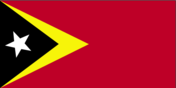
Flag description
red, with a black isosceles triangle (based on the hoist side) superimposed on a slightly longer yellow arrowhead that extends to the center of the flag; there is a white star in the center of the black triangle Economy East Timor
GDP - composition by sector
- agriculture
- 25.4%
- industry
- 17.2%
- services
- 57.4% (2001)
GDP - per capita
purchasing power parity - $400 (2004 est.)
GDP - real growth rate
1% (2004 est.)
GDP (purchasing power parity)
$370 million (2004 est.)
Geographic coordinates
8 50 S, 125 55 E
Geography - note
Timor comes from the Malay word for "East"; the island of Timor is part of the Malay Archipelago and is the largest and easternmost of the Lesser Sunda Islands People East Timor
Government type
Republic
Heliports
1 (2004 est.) Military East Timor
Highways
- paved
- 428 km
- total
- 3,800 km
- unpaved
- 3,372 km (1995)
HIV/AIDS - adult prevalence rate
NA
HIV/AIDS - deaths
NA
HIV/AIDS - people living with HIV/AIDS
NA
Household income or consumption by percentage share
lowest 10%: NA highest 10%: NA
Illicit drugs
NA This page was last updated on 20 October, 2005 ======================================================================
Imports
$167 million (2004 est.)
Imports - commodities
food, gasoline, kerosene, machinery
Imports - partners
NA
Independence
28 November 1975 (date of proclamation of independence from Portugal); note - 20 May 2002 is the official date of international recognition of East Timor's independence from Indonesia
Industrial production growth rate
8.5%
Industries
printing, soap manufacturing, handicrafts, woven cloth
Infant mortality rate
- female
- 40.8 deaths/1,000 live births (2005 est.)
- male
- 53.71 deaths/1,000 live births
- total
- 47.41 deaths/1,000 live births
Inflation rate (consumer prices)
4% (2003 est.)
International organization participation
ACP, AsDB, FAO, G-77, IBRD, ICCt, IDA, IFAD, IFC, IFRCS (observer), ILO, IMF, Interpol, IOC, MIGA, OPCW, PIF (observer), UN, UNESCO, UNIDO, UPU, WCO, WHO
Internet country code
.tl; note - ICANN approved the change from .tp in January 2005
Internet Service Providers (ISPs)
NA
Internet users
NA Transportation East Timor
Irrigated land
1,065 sq km (est.)
Judicial branch
Supreme Court of Justice - constitution calls for one judge to be appointed by National Parliament and rest appointed by Superior Council for Judiciary; note - until Supreme Court is established, Court of Appeals is highest court
Labor force
NA
Labor force - by occupation
NA
Land boundaries
- border countries
- Indonesia 228 km
- total
- 228 km
Land use
- arable land
- 4.71%
- other
- 94.62% (2001)
- permanent crops
- 0.67%
Languages
Tetum (official), Portuguese (official), Indonesian, English note: there are about 16 indigenous languages; Tetum, Galole, Mambae, and Kemak are spoken by significant numbers of people
Legal system
UN-drafted legal system based on Indonesian law remains in place but will be replaced by civil and penal codes based on Portuguese law (2004)
Legislative branch
- unicameral National Parliament (number of seats can vary, minimum requirement of 52 and a maximum of 65 seats; members elected by popular vote to serve five-year terms); note - for its first term of office, the National Parliament is comprised of 88 members on an exceptional basis
- election results
- percent of vote by party - FRETILIN 57.37%, PD 8.72%, PSD 8.18%, ASDT 7.84%, UDT 2.36%, PNT 2.21%, KOTA 2.13%, PPT 2.01%, PDC 1.98%, PST 1.78%, independents/other 5.42%; seats by party - FRETILIN 55, PD 7, PSD 6, ASDT 6, PDC 2, UDT 2, KOTA 2, PNT 2, PPT 2, UDC/PDC 1, PST 1, PL 1, independent 1
- elections
- (next to be held August 2006); direct elections for national parliament were never held; elected delegates to the national convention named themselves legislators instead of having elections; hence the exceptional numbers for this term of the national parliament.
Life expectancy at birth
- female
- 68.29 years (2005 est.)
- male
- 63.63 years
- total population
- 65.9 years
Literacy
- definition: age 15 and over can read and write
- total population
- 58.6% (2002) Government East Timor
Location
Southeastern Asia, northwest of Australia in the Lesser Sunda Islands at the eastern end of the Indonesian archipelago; note - East Timor includes the eastern half of the island of Timor, the Oecussi (Ambeno) region on the northwest portion of the island of Timor, and the islands of Pulau Atauro and Pulau Jaco
Manpower available for military service
NA
Manpower fit for military service
males age 18-49: NA
Manpower reaching military service age annually
NA
Map references
Southeast Asia
Maritime claims
- continental shelf
- NA
- exclusive economic zone
- NA
- exclusive fishing zone
- NA
- territorial sea
- NA
Median age
- female
- 20.35 years (2005 est.)
- male
- 20.46 years
- total
- 20.41 years
Military expenditures - dollar figure
$4.4 million (FY03)
Military expenditures - percent of GDP
NA Transnational Issues East Timor
Military service age and obligation
18 years of age for voluntary military service (2001)
National holiday
Independence Day, 28 November (1975)
Nationality
- adjective
- Timorese
- noun
- Timorese
Natural hazards
floods and landslides are common; earthquakes, tsunamis, tropical cyclones
Natural resources
gold, petroleum, natural gas, manganese, marble
Net migration rate
0 migrant(s)/1,000 population (2005 est.)
Political parties and leaders
Associacao Social-Democrata Timorense or ASDT [Francisco Xavier do AMARAL]; Christian Democratic Party of Timor or PDC [Antonio XIMENES]; Christian Democratic Union of Timor or UDC [Vicente da Silva GUTERRES]; Democratic Party or PD [Fernando de ARAUJO]; Liberal Party or PL [leader NA]; Maubere Democratic Party or PDM [leader NA]; People's Party of Timor or PPT [Jacob XAVIER]; Revolutionary Front of Independent East Timor or FRETILIN [Lu OLO]; Social Democrat Party of East Timor or PSD [Mario CARRASCALAO]; Socialist Party of Timor or PST [leader Avelino COELHO]; Sons of the Mountain Warriors (also known as Association of Timorese Heroes) or KOTA [Clementino dos Reis AMARAL]; Timor Democratic Union or UDT [Joao CARRASCALAO]; Timor Labor Party or PTT [Paulo Freitas DA SILVA]; Timorese Nationalist Party or PNT [Abilio ARAUJO]; Timorese Popular Democratic Association or APODETI [Frederico Almeida-Santos DA COSTA]
Political pressure groups and leaders
Popular Council for the Defense of the Democratic Republic of East Timor or CPD-RDTL [leader Antonio-Aitahan MATAK] is largest political pressure group; it rejects current government and claims to be rightful government; Kolimau 2000 [leader Dr. Bruno MAGALHAES] is another opposition group; dissatisfied veterans of struggle against Indonesia, led by one-time government advisor Cornelio GAMA (also known as L-7), also play an important role in pressuring government
Population
1,040,880 note: other estimates range as low as 800,000 (July 2005 est.)
Population below poverty line
42% (2003 est.)
Population growth rate
2.09% (2005 est.)
Ports and harbors
Dili
Radio broadcast stations
AM NA, FM NA, shortwave NA
Radios
NA
Religions
Roman Catholic 90%, Muslim 4%, Protestant 3%, Hindu 0.5%, Buddhist, Animist (1992 est.)
Sex ratio
- at birth
- 1.05 male(s)/female under 15 years: 1.03 male(s)/female 15-64 years: 1.04 male(s)/female 65 years and over: 0.96 male(s)/female
- total population
- 1.04 male(s)/female (2005 est.)
Suffrage
17 years of age; universal
Telephone system
NA
Telephones - main lines in use
NA
Telephones - mobile cellular
NA
Television broadcast stations
NA
Televisions
NA
Terrain
mountainous
Total fertility rate
3.61 children born/woman (2005 est.)
Unemployment rate
50% (including underemployment) (1992 est.)