2023 Edition
CIA World Factbook 2023 (factbook.json @ 0d4fa4984ecb)
Introduction
Background
In the 10th century, Muslim merchants established some of The Gambia’s earliest large settlements as trans-Saharan trade hubs. These settlements eventually grew into major export centers sending slaves, gold, and ivory across the Sahara. Between the 16th and 17th centuries, European colonial powers began establishing trade with The Gambia. In 1664, the United Kingdom established a colony in The Gambia focused on exporting enslaved people across the Atlantic. During the roughly 300 years of the trans-Atlantic slave trade, the UK and other European powers may have exported as many as 3 million people from The Gambia. The Gambia gained its independence from the UK in 1965. Geographically surrounded by Senegal, it formed the short-lived confederation of Senegambia between 1982 and 1989. In 1994, Yahya JAMMEH led a military coup overthrowing the president and banning political activity. He subsequently won every presidential election until 2016, when he lost to Adama BARROW, who headed an opposition coalition during free and fair elections. BARROW won reelection in December 2021. The Gambia is the only member of the Economic Community of West African States that does not have presidential term limits. Since the 2016 election, The Gambia and the US have enjoyed improved relations. US assistance to the country has supported military education and training programs, capacity building, and democracy-strengthening activities.
Geography
Area
- land
- 10,120 sq km
- total
- 11,300 sq km
- water
- 1,180 sq km
Area - comparative
slightly less than twice the size of Delaware
Climate
tropical; hot, rainy season (June to November); cooler, dry season (November to May)
Coastline
80 km
Elevation
- highest point
- unnamed elevation 63 m; 3 km southeast of the town of Sabi
- lowest point
- Atlantic Ocean 0 m
- mean elevation
- 34 m
Geographic coordinates
13 28 N, 16 34 W
Geography - note
almost an enclave of Senegal; smallest country on the African mainland
Irrigated land
50 sq km (2012)
Land boundaries
- border countries
- Senegal 749 km
- total
- 749 km
Land use
- agricultural land
- 56.1% (2018 est.)
- agricultural land: arable land
- arable land: 41% (2018 est.)
- agricultural land: permanent crops
- permanent crops: 0.5% (2018 est.)
- agricultural land: permanent pasture
- permanent pasture: 14.6% (2018 est.)
- forest
- 43.9% (2018 est.)
- other
- 0% (2018 est.)
Location
Western Africa, bordering the North Atlantic Ocean and Senegal
Major aquifers
Senegalo-Mauritanian Basin
Major rivers (by length in km)
Gambia river mouth (shared with Senegal and Guinea [s]) - 1,094 kmnote – [s] after country name indicates river source; [m] after country name indicates river mouth
Map references
Africa
Maritime claims
- contiguous zone
- 18 nm
- continental shelf
- extent not specified
- exclusive fishing zone
- 200 nm
- territorial sea
- 12 nm
Natural hazards
droughts
Natural resources
fish, clay, silica sand, titanium (rutile and ilmenite), tin, zircon
Population distribution
settlements are found scattered along the Gambia River; the largest communities, including the capital of Banjul, and the country's largest city, Serekunda, are found at the mouth of the Gambia River along the Atlantic coast as shown in this population distribution map
Terrain
flood plain of the Gambia River flanked by some low hills
People and Society
Age structure
- 0-14 years
- 38.86% (male 484,113/female 475,134)
- 15-64 years
- 57.57% (male 700,049/female 721,057)
- 65 years and over
- 3.57% (2023 est.) (male 38,954/female 49,262)
Alcohol consumption per capita
- beer
- 0.21 liters of pure alcohol (2019 est.)
- other alcohols
- 2.44 liters of pure alcohol (2019 est.)
- spirits
- 0.02 liters of pure alcohol (2019 est.)
- total
- 2.67 liters of pure alcohol (2019 est.)
- wine
- 0 liters of pure alcohol (2019 est.)
Birth rate
28 births/1,000 population (2023 est.)
Child marriage
- men married by age 18
- 0.2% (2020 est.)
- women married by age 15
- 5.6%
- women married by age 18
- 23.1%
Children under the age of 5 years underweight
11.6% (2019/20)
Contraceptive prevalence rate
18.9% (2019/20)
Current health expenditure
2.6% of GDP (2020)
Currently married women (ages 15-49)
60.9% (2023 est.)
Death rate
5.7 deaths/1,000 population (2023 est.)
Demographic profile
The Gambia’s youthful age structure – approximately 55% of the population is under the age of 25 as of 2021 – is likely to persist because the country’s total fertility rate remains strong at nearly 4 children per woman. The overall literacy rate is around 50%, and is significantly lower for women than for men. At least 70% of the populace are farmers who are reliant on rain-fed agriculture and cannot afford improved seeds and fertilizers. Crop failures caused by droughts between 2011 and 2013 increased poverty, food shortages, and malnutrition. The Gambia is a source country for migrants and a transit and destination country for migrants and refugees. Since the 1980s, economic deterioration, drought, and high unemployment, especially among youths, have driven both domestic migration (largely urban) and migration abroad (legal and illegal). Emigrants are largely skilled workers, including doctors and nurses, and provide a significant amount of remittances. The top receiving countries for Gambian emigrants are Spain, the US, Nigeria, Senegal, and the UK. While the Gambia and Spain do not share historic, cultural, or trade ties, rural Gambians have migrated to Spain in large numbers because of its proximity and the availability of jobs in its underground economy (this flow slowed following the onset of Spain’s late 2007 economic crisis). The Gambia’s role as a host country to refugees is a result of wars in several of its neighboring West African countries. Since 2006, refugees from the Casamance conflict in Senegal have replaced their pattern of flight and return with permanent settlement in The Gambia, often moving in with relatives along the Senegal-Gambia border. The strain of providing for about 7,400 Casamance refugees increased poverty among Gambian villagers. The number of refugees decreased to around 3,500 by 2022.
Dependency ratios
- elderly dependency ratio
- 4.5
- potential support ratio
- 22.2 (2021 est.)
- total dependency ratio
- 85
- youth dependency ratio
- 80.5
Drinking water source
- improved: rural
- rural: 85.7% of population
- improved: total
- total: 89.5% of population
- improved: urban
- urban: 91.8% of population
- unimproved: rural
- rural: 14.3% of population
- unimproved: total
- total: 10.5% of population (2020 est.)
- unimproved: urban
- urban: 8.2% of population
Education expenditures
2.8% of GDP (2020 est.)
Ethnic groups
Mandinka/Jahanka 33.3%, Fulani/Tukulur/Lorobo 18.2%, Wolof 12.9%, Jola/Karoninka 11%, Serahuleh 7.2%, Serer 3.5%, other 4%, non-Gambian 9.9% (2019-20 est.)
Gross reproduction rate
1.8 (2023 est.)
Hospital bed density
1.1 beds/1,000 population (2011)
Infant mortality rate
- female
- 32.9 deaths/1,000 live births
- male
- 39.9 deaths/1,000 live births
- total
- 36.4 deaths/1,000 live births (2023 est.)
Languages
English (official), Mandinka, Wolof, Fula, other indigenous vernaculars
Life expectancy at birth
- female
- 69.8 years
- male
- 66.3 years
- total population
- 68 years (2023 est.)
Literacy
- definition
- age 15 and over can read and write
- female
- 51.2% (2021)
- male
- 65.2%
- total population
- 58.1%
Major infectious diseases
- animal contact diseases
- rabies
- degree of risk
- very high (2023)
- food or waterborne diseases
- bacterial and protozoal diarrhea, hepatitis A, and typhoid fever
- respiratory diseases
- meningococcal meningitis
- vectorborne diseases
- malaria and dengue fever
- water contact diseases
- schistosomiasis
Major urban areas - population
- 481,000 BANJUL (capital) (2023)
- note
- note: includes the local government areas of Banjul and Kanifing
Maternal mortality ratio
458 deaths/100,000 live births (2020 est.)
Median age
- female
- 20.3 years
- male
- 19.5 years
- total
- 19.9 years (2023 est.)
Mother's mean age at first birth
- 20.7 years (2019/20 est.)
- note
- note: data represents median age at first birth among women 25-49
Nationality
- adjective
- Gambian
- noun
- Gambian(s)
Net migration rate
0 migrant(s)/1,000 population (2023 est.)
Obesity - adult prevalence rate
10.3% (2016)
Physicians density
0.08 physicians/1,000 population (2020)
Population
2,468,569 (2023 est.)
Population distribution
settlements are found scattered along the Gambia River; the largest communities, including the capital of Banjul, and the country's largest city, Serekunda, are found at the mouth of the Gambia River along the Atlantic coast as shown in this population distribution map
Population growth rate
2.23% (2023 est.)
Religions
Muslim 96.4%, Christian 3.5%, other or none 0.1% (2019-20 est.)
Sanitation facility access
- improved: rural
- rural: 33.6% of population
- improved: total
- total: 60% of population
- improved: urban
- urban: 75.8% of population
- unimproved: rural
- rural: 66.4% of population
- unimproved: total
- total: 40% of population (2020 est.)
- unimproved: urban
- urban: 24.2% of population
Sex ratio
- 0-14 years
- 1.02 male(s)/female
- 15-64 years
- 0.97 male(s)/female
- 65 years and over
- 0.79 male(s)/female
- at birth
- 1.03 male(s)/female
- total population
- 0.98 male(s)/female (2023 est.)
Tobacco use
- female
- 0.8% (2020 est.)
- male
- 21.4% (2020 est.)
- total
- 11.1% (2020 est.)
Total fertility rate
3.66 children born/woman (2023 est.)
Urbanization
- rate of urbanization
- 3.75% annual rate of change (2020-25 est.)
- urban population
- 64.5% of total population (2023)
Government
Administrative divisions
5 regions, 1 city*, and 1 municipality**; Banjul*, Central River, Kanifing**, Lower River, North Bank, Upper River, West Coast
Capital
- etymology
- Banjul is located on Saint Mary's Island at the mouth of the Gambia River; the Mandinka used to gather fibrous plants on the island for the manufacture of ropes; "bang julo" is Mandinka for "rope fiber"; mispronunciation over time caused the term became the word Banjul
- geographic coordinates
- 13 27 N, 16 34 W
- name
- Banjul
- time difference
- UTC 0 (5 hours ahead of Washington, DC, during Standard Time)
Citizenship
- citizenship by birth
- yes
- citizenship by descent only
- yes
- dual citizenship recognized
- no
- residency requirement for naturalization
- 5 years
Constitution
- amendments
- proposed by the National Assembly; passage requires at least three-fourths majority vote by the Assembly membership in each of several readings and approval by the president of the republic; a referendum is required for amendments affecting national sovereignty, fundamental rights and freedoms, government structures and authorities, taxation, and public funding; passage by referendum requires participation of at least 50% of eligible voters and approval by at least 75% of votes cast; amended 2001, 2004, 2018
- history
- previous 1965 (Independence Act), 1970; latest adopted 8 April 1996, approved by referendum 8 August 1996, effective 16 January 1997; note - in early 2018, the "Constitutional Review Commission," was established to draft and assist in instituting a new constitution; a second draft completed in March 2020 was rejected by the National Assembly in September; the president announced in January 2022 government plans to draft a new constitution
Country name
- conventional long form
- Republic of The Gambia
- conventional short form
- The Gambia
- etymology
- named for the Gambia River that flows through the heart of the country
Diplomatic representation from the US
- chief of mission
- Ambassador Sharon L. CROMER (since 18 March 2022)
- email address and website
- ConsularBanjul@state.govhttps://gm.usembassy.gov/
- embassy
- Kairaba Avenue, Fajara, P.M.B. 19, Banjul
- FAX
- [220] 439-2475
- mailing address
- 2070 Banjul Place, Washington DC 20521-2070
- telephone
- [220] 439-2856
Diplomatic representation in the US
- chancery
- 5630 16th Street NW, Washington, DC 20011
- chief of mission
- Ambassador Momodou Lamin BAH (12 December 2022)
- email address and website
- info@gambiaembassydc.us; gambiaembassydc@gmail.comhttps://www.gambiaembassydc.us/home
- FAX
- [1] (202) 785-1430
- telephone
- [1] (202) 785-1399; [1] (202) 785-1428
Executive branch
- cabinet
- Cabinet appointed by the president
- chief of state
- President Adama BARROW (since 19 January 2022); Vice President Isatou TOURAY (since 15 March 2019); note - the president is both chief of state and head of government
- election results
- 2021: Adama BARROW reelected president; percent of vote - Adama BARROW (NPP) 53.2%, Ousainou DARBOE (UDP) 27.7%, Mamma KANDEH (GDC) 12.3%, other 6.8%2016: Adama BARROW elected president; percent of vote - Adama BARROW (Coalition 2016) 43.3%, Yahya JAMMEH (APRC) 39.6%, Mamma KANDEH (GDC) 17.1%
- elections/appointments
- president directly elected by simple majority popular vote for a 5-year term (no term limits); election last held on 4 December 2021 (next to be held in 2026); vice president appointed by the president
- head of government
- President Adama BARROW (since 19 January 2022); Vice President Isatou TOURAY (since 15 March 2019)
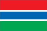
Flag description
three equal horizontal bands of red (top), blue with white edges, and green; red stands for the sun and the savannah, blue represents the Gambia River, and green symbolizes forests and agriculture; the white stripes denote unity and peace
Government type
presidential republic
Independence
18 February 1965 (from the UK)
International law organization participation
accepts compulsory ICJ jurisdiction with reservations; accepts ICCt jurisdiction
International organization participation
ACP, AfDB, AU, ECOWAS, FAO, G-77, IBRD, ICAO, ICCt, ICRM, IDA, IDB, IFAD, IFC, IFRCS, ILO, IMF, IMO, Interpol, IOC, IOM, IPU, ISO (correspondent), ITSO, ITU, ITUC (NGOs), MIGA, NAM, OIC, OPCW, UN, UNAMID, UNCTAD, UNESCO, UNHRC, UNIDO, UNISFA, UNMIL, UNOCI, UNWTO, UPU, WCO, WFTU (NGOs), WHO, WIPO, WMO, WTO
Judicial branch
- highest court(s)
- Supreme Court of The Gambia (consists of the chief justice and 6 justices; court sessions held with 5 justices)
- judge selection and term of office
- justices appointed by the president after consultation with the Judicial Service Commission, a 6-member independent body of high-level judicial officials, a presidential appointee, and a National Assembly appointee; justices appointed for life or until mandatory retirement at age 75
- subordinate courts
- Court of Appeal; High Court; Special Criminal Court; Khadis or Muslim courts; district tribunals; magistrates courts; cadi courts
Legal system
mixed legal system of English common law, Islamic law, and customary law
Legislative branch
- description
- unicameral National Assembly (58 seats; 53 members directly elected in single-seat constituencies by simple majority vote and 5 appointed by the president; members serve 5-year terms)
- election results
- percent of vote by party - NPP 33.9%, UDP 28.3%, independent 22.6%, NRP 7.5%, PDOIS 3.7%, APRL 3.7%; seats by party - NPP 18, UDP 15, independent 12,NRP 4, APRL 2, PDOIS 2; composition - men 52, women 6, percent of women 10.3%
- elections
- last held on 9 April 2022 (next to be held in 2027)
National anthem
- lyrics/music
- Virginia Julie HOWE/adapted by Jeremy Frederick HOWE
- name
- "For The Gambia, Our Homeland"
- note
- note: adopted 1965; the music is an adaptation of the traditional Mandinka song "Foday Kaba Dumbuya"
National heritage
- selected World Heritage Site locales
- Kunta Kinteh Island and Related Sites; Stone Circles of Senegambia
- total World Heritage Sites
- 2 (both cultural)
National holiday
Independence Day, 18 February (1965)
National symbol(s)
lion; national colors: red, blue, green, white
Political parties and leaders
Alliance for Patriotic Reorientation and Construction or APRC [Fabakary JATTA]Coalition 2016 [collective leadership] (electoral coalition includes UDP, PDOIS, NRP, GMC, GDC, PPP, and GPDP)Gambia Democratic Congress or GDC [Mama KANDEH]Gambia Moral Congress or GMC [Mai FATTY]Gambia Party for Democracy and Progress or GPDP [Sarja JARJOU]National Convention Party or NCP [Yaya SANYANG and Majanko SAMUSA (both claiming leadership)]National Democratic Action Movement or NDAM [Lamin Yaa JUARA]National People's Party or NPP [Adama BARROW]National Reconciliation Party or NRP [Hamat BAH]People's Democratic Organization for Independence and Socialism or PDOIS [Halifa SALLAH]People's Progressive Party or PPP [Yaya CEESAY)]United Democratic Party or UDP [Ousainou DARBOE]
Suffrage
18 years of age; universal
Economy
Agricultural products
groundnuts, milk, oil palm fruit, millet, sorghum, rice, maize, vegetables, cassava, fruit
Budget
- expenditures
- $353 million (2018 est.)
- revenues
- $252 million (2018 est.)
Budget surplus (+) or deficit (-)
-2.6% (of GDP) (2017 est.)
Current account balance
- Current account balance 2019
- -$37.078 million (2019 est.)
- Current account balance 2020
- -$86.553 million (2020 est.)
- Current account balance 2021
- -$94.081 million (2021 est.)
Debt - external
- Debt - external 31 December 2016
- $571.2 million (31 December 2016 est.)
- Debt - external 31 December 2017
- $586.8 million (31 December 2017 est.)
Economic overview
small West African economy; COVID-19 reversed robust growth trends; good fiscal management; substantial foreign direct investment and remittances; G20 Debt Service Suspension Initiative participant; widespread poverty; increasing Chinese relations
Exchange rates
- Currency
- dalasis (GMD) per US dollar -
- Exchange rates 2017
- 46.609 (2017 est.)
- Exchange rates 2018
- 48.152 (2018 est.)
- Exchange rates 2019
- 50.062 (2019 est.)
- Exchange rates 2020
- 51.502 (2020 est.)
- Exchange rates 2021
- 51.484 (2021 est.)
Exports
- Exports 2019
- $360.208 million (2019 est.)
- Exports 2020
- $175.682 million (2020 est.)
- Exports 2021
- $135.448 million (2021 est.) note: data are in current year dollars
Exports - commodities
cashews, lumber, refined petroleum, shellfish, scrap iron, fish, sesame seeds (2021)
Exports - partners
China 38%, India 22%, Mali 7%, Chile 5% (2017)
Fiscal year
calendar year
GDP - composition, by end use
- exports of goods and services
- 20.8% (2017 est.)
- government consumption
- 12% (2017 est.)
- household consumption
- 90.7% (2017 est.)
- imports of goods and services
- -40% (2017 est.)
- investment in fixed capital
- 19.2% (2017 est.)
- investment in inventories
- -2.7% (2017 est.)
GDP - composition, by sector of origin
- agriculture
- 20.4% (2017 est.)
- industry
- 14.2% (2017 est.)
- services
- 65.4% (2017 est.)
GDP (official exchange rate)
$1.746 billion (2019 est.)
Gini Index coefficient - distribution of family income
- Gini Index coefficient - distribution of family income 2015
- 35.9 (2015 est.)
Household income or consumption by percentage share
- highest 10%
- 36.9% (2003)
- lowest 10%
- 2%
Imports
- Imports 2019
- $641 million (2019 est.)
- Imports 2020
- $691 million (2020 est.)
- Imports 2021
- $726 million (2021 est.) note: data are in current year dollars
Imports - commodities
clothing and apparel, refined petroleum, rice, raw sugar, palm oil (2019)
Imports - partners
China 33%, India 10%, Senegal 5%, Brazil 5% (2019)
Industrial production growth rate
10.4% (2021 est.)
Industries
peanuts, fish, hides, tourism, beverages, agricultural machinery assembly, woodworking, metalworking, clothing
Inflation rate (consumer prices)
- Inflation rate (consumer prices) 2019
- 7.12% (2019 est.)
- Inflation rate (consumer prices) 2020
- 5.93% (2020 est.)
- Inflation rate (consumer prices) 2021
- 7.37% (2021 est.)
Labor force
856,100 (2021 est.)
Population below poverty line
48.6% (2015 est.)
Public debt
- Public debt 2016
- 82.3% of GDP (2016 est.)
- Public debt 2017
- 88% of GDP (2017 est.)
Real GDP (purchasing power parity)
- note
- note: data are in 2017 dollars
- Real GDP (purchasing power parity) 2019
- $5.227 billion (2019 est.)
- Real GDP (purchasing power parity) 2020
- $5.258 billion (2020 est.)
- Real GDP (purchasing power parity) 2021
- $5.482 billion (2021 est.)
Real GDP growth rate
- Real GDP growth rate 2019
- 6.22% (2019 est.)
- Real GDP growth rate 2020
- 0.59% (2020 est.)
- Real GDP growth rate 2021
- 4.27% (2021 est.)
Real GDP per capita
- note
- note: data are in 2017 dollars
- Real GDP per capita 2019
- $2,100 (2019 est.)
- Real GDP per capita 2020
- $2,000 (2020 est.)
- Real GDP per capita 2021
- $2,100 (2021 est.)
Reserves of foreign exchange and gold
- Reserves of foreign exchange and gold 31 December 2019
- $256.957 million (31 December 2019 est.)
- Reserves of foreign exchange and gold 31 December 2020
- $387.046 million (31 December 2020 est.)
- Reserves of foreign exchange and gold 31 December 2021
- $652.671 million (31 December 2021 est.)
Taxes and other revenues
20.3% (of GDP) (2017 est.)
Unemployment rate
- note
- NA
- Unemployment rate 2019
- 9.5% (2019 est.)
- Unemployment rate 2020
- 11.08% (2020 est.)
- Unemployment rate 2021
- 11.21% (2021 est.)
Youth unemployment rate (ages 15-24)
- female
- 20.5%
- male
- 11.4%
- total
- 15.5% (2021 est.)
Energy
Carbon dioxide emissions
- from coal and metallurgical coke
- 0 metric tonnes of CO2 (2019 est.)
- from consumed natural gas
- 0 metric tonnes of CO2 (2019 est.)
- from petroleum and other liquids
- 606,000 metric tonnes of CO2 (2019 est.)
- total emissions
- 606,000 metric tonnes of CO2 (2019 est.)
Coal
- consumption
- 0 metric tons (2020 est.)
- exports
- 0 metric tons (2020 est.)
- imports
- 0 metric tons (2020 est.)
- production
- 0 metric tons (2020 est.)
- proven reserves
- 0 metric tons (2019 est.)
Electricity
- consumption
- 235.035 million kWh (2019 est.)
- exports
- 0 kWh (2019 est.)
- imports
- 0 kWh (2019 est.)
- installed generating capacity
- 137,000 kW (2020 est.)
- transmission/distribution losses
- 69.8 million kWh (2019 est.)
Electricity access
- electrification - rural areas
- 31.2% (2021)
- electrification - total population
- 63.6% (2021)
- electrification - urban areas
- 82.5% (2021)
- population without electricity
- (2020) less than 1 million
Electricity generation sources
- biomass and waste
- 0% of total installed capacity (2020 est.)
- fossil fuels
- 98.9% of total installed capacity (2020 est.)
- geothermal
- 0% of total installed capacity (2020 est.)
- hydroelectricity
- 0% of total installed capacity (2020 est.)
- nuclear
- 0% of total installed capacity (2020 est.)
- solar
- 1% of total installed capacity (2020 est.)
- tide and wave
- 0% of total installed capacity (2020 est.)
- wind
- 0% of total installed capacity (2020 est.)
Energy consumption per capita
- Total energy consumption per capita 2019
- 3.547 million Btu/person (2019 est.)
Natural gas
- consumption
- 0 cubic meters (2021 est.)
- exports
- 0 cubic meters (2021 est.)
- imports
- 0 cubic meters (2021 est.)
- production
- 0 cubic meters (2021 est.)
- proven reserves
- 0 cubic meters (2021 est.)
Petroleum
- crude oil and lease condensate exports
- 0 bbl/day (2018 est.)
- crude oil and lease condensate imports
- 0 bbl/day (2018 est.)
- crude oil estimated reserves
- 0 barrels (2021 est.)
- refined petroleum consumption
- 3,900 bbl/day (2019 est.)
- total petroleum production
- 0 bbl/day (2021 est.)
Refined petroleum products - exports
42 bbl/day (2015 est.)
Refined petroleum products - imports
3,738 bbl/day (2015 est.)
Refined petroleum products - production
0 bbl/day (2017 est.)
Communications
Broadband - fixed subscriptions
- subscriptions per 100 inhabitants
- 0.2 (2020 est.)
- total
- 5,000 (2020 est.)
Broadcast media
1 state-run TV-channel; one privately-owned TV-station; 1 Online TV-station; three state-owned radio station and 31 privately owned radio stations; eight community radio stations; transmissions of multiple international broadcasters are available, some via shortwave radio; cable and satellite TV subscription services are obtainable in some parts of the country (2019)
Internet country code
.gm
Internet users
- percent of population
- 33% (2021 est.)
- total
- 858,000 (2021 est.)
Telecommunication systems
- domestic
- fixed-line subscriptions are 2 per 100 and mobile-cellular teledensity nearly 110 per 100 persons (2021)
- general assessment
- Gambia’s telecom market has five mobile networks providing effective competition; mobile subscriptions are well above the African average, itself a testament to the poor condition of the fixed-line infrastructure and the lack of availability of fixed services in many rural areas of the country; there are only four licensed ISPs, which are small networks serving local areas, and so competition is minimal; their limited services are complemented by the fixed-wireless offerings of three of the MNOs; the government has embarked on a National Broadband Network program aimed at closing the digital divide affecting many parts of the country; despite efforts to improve internet connectivity, the country ranks among the lowest globally in terms of digital readiness. (2022)
- international
- country code - 220; landing point for the ACE submarine cable to West Africa and Europe; microwave radio relay links to Senegal and Guinea-Bissau; satellite earth station - 1 Intelsat (Atlantic Ocean) (2019)
Telephones - fixed lines
- subscriptions per 100 inhabitants
- 2 (2021 est.)
- total subscriptions
- 60,000 (2021 est.)
Telephones - mobile cellular
- subscriptions per 100 inhabitants
- 100 (2021 est.)
- total subscriptions
- 27 million (2021 est.)
Transportation
Airports
1 (2021)
Airports - with paved runways
- 1
- note
- note: paved runways have a concrete or asphalt surface but not all have facilities for refueling, maintenance, or air traffic control; the length of a runway required for aircraft to safely operate depends on a number of factors including the type of aircraft, the takeoff weight (including passengers, cargo, and fuel), engine types, flap settings, landing speed, elevation of the airport, and average maximum daily air temperature; paved runways can reach a length of 5,000 m (16,000 ft.), but the “typical” length of a commercial airline runway is between 2,500-4,000 m (8,000-13,000 ft.)
Civil aircraft registration country code prefix
C5
Merchant marine
- by type
- general cargo 1, other 8
- total
- 9 (2022)
National air transport system
- annual passenger traffic on registered air carriers
- 53,735 (2018)
- inventory of registered aircraft operated by air carriers
- 6
- number of registered air carriers
- 2 (2020)
Ports and terminals
- major seaport(s)
- Banjul
Roadways
- paved
- 518 km (2011)
- total
- 2,977 km (2011)
- unpaved
- 2,459 km (2011)
Waterways
390 km (2010) (on River Gambia; small oceangoing vessels can reach 190 km)
Military and Security
Military - note
the Gambian security forces have a history of involvement in domestic politics, including multiple coups attempts and mutinies, with the latest being an attempted coup in 2022; since 2017, Gambia’s security sector has been undergoing reforms as part of a national reconstruction effort to recover from the 22 years of Yahya JAMMEH’s autocratic rule under which the security forces were severely under-resourced in terms of finances and equipment and were largely directed towards regime protection and suppressing dissent; international partners, including member states of the EU, particularly France and Germany, Turkey, and the US have provided support to military and police reforms; several members of the Economic Community of West African States (ECOWAS) have also provided security forces for stability, as well as assistance and training through the ECOWAS Mission in the Gambia (ECOMIG); as of 2023, ECOMIG continued to provide about 1,000 military and gendarmerie personnel from Ghana, Nigeria, and Senegalthe GAF is a lightly armed force with about five small infantry battalions, a handful of coastal patrol boats, and a few aircraft; in addition to external defense, the responsibilities of the GAF include providing maritime security, countering human trafficking, aiding civil authorities in emergencies and natural disaster relief, and engaging in activities such as engineering, education, health, and agriculture for domestic socio-economic development; the GAF also participates in peacekeeping missions, and since its first deployments in the 1990s, has been involved in more than 10 UN peacekeeping missions while contributing about 4,000 total troops the GAF traces its origins to the Gambia Regiment of the British Army; established in 1901, the Gambia Regiment was part of the West African Frontier Force (WAFF, later Royal West African Frontier Force or RWAFF) and served in both World Wars, including the British 1944-45 military campaign in Burma; the Gambia Regiment was disbanded in 1958 and replaced by the Field Force, a police paramilitary unit; the Field Force was responsible for The Gambia’s security until the establishment of the GAF in 1985; in addition, a defense agreement signed in 1965 between The Gambia and Senegal provided mutual assistance in the face of an external threat; from 1981-1989, The Gambia and Senegal formed a Confederal Army that was made up of troops from both countries (2023)
Military and security forces
- Gambian Armed Forces (GAF; aka Armed Forces of the Gambia): the Gambian National Army (GNA), Gambia Navy, Gambia Air Force, Republican National Guard (2023)
- note
- note: the National Guard is responsible for VIP protection, riot control, and presidential security; the Gambia Police Force under the Ministry of Interior maintains internal security
Military and security service personnel strengths
estimated 3,000 military personnel (2023)
Military equipment inventories and acquisitions
the GAF has a limited and obsolescent or secondhand equipment inventory originating from several suppliers, including China, Turkey, the UK, and the US (2023)
Military expenditures
- Military Expenditures 2018
- 0.7% of GDP (2018 est.)
- Military Expenditures 2019
- 0.8% of GDP (2019 est.)
- Military Expenditures 2020
- 0.8% of GDP (2020 est.)
- Military Expenditures 2021
- 0.8% of GDP (2021 est.)
- Military Expenditures 2022
- 0.7% of GDP (2022 est.)
Military service age and obligation
18-25 years of age for male and female voluntary military service (18-22 for officers); no conscription; service obligation six months (2023)
Transnational Issues
Disputes - international
border issues include attempts to stem refugees, cross-border raids, arms smuggling, and other illegal activities by separatists from southern Senegal's Casamance region, as well as from conflicts in other west African states
Refugees and internally displaced persons
- IDPs
- 5,600 (2022)
Environment
Air pollutants
- carbon dioxide emissions
- 0.53 megatons (2016 est.)
- methane emissions
- 1.96 megatons (2020 est.)
- particulate matter emissions
- 39.1 micrograms per cubic meter (2019 est.)
Climate
tropical; hot, rainy season (June to November); cooler, dry season (November to May)
Environment - current issues
deforestation due to slash-and-burn agriculture; desertification; water pollution; water-borne diseases
Environment - international agreements
- party to
- Biodiversity, Climate Change, Climate Change-Kyoto Protocol, Climate Change-Paris Agreement, Desertification, Endangered Species, Hazardous Wastes, Law of the Sea, Nuclear Test Ban, Ozone Layer Protection, Ship Pollution, Wetlands, Whaling
- signed, but not ratified
- Comprehensive Nuclear Test Ban
Land use
- agricultural land
- 56.1% (2018 est.)
- agricultural land: arable land
- arable land: 41% (2018 est.)
- agricultural land: permanent crops
- permanent crops: 0.5% (2018 est.)
- agricultural land: permanent pasture
- permanent pasture: 14.6% (2018 est.)
- forest
- 43.9% (2018 est.)
- other
- 0% (2018 est.)
Major aquifers
Senegalo-Mauritanian Basin
Major rivers (by length in km)
Gambia river mouth (shared with Senegal and Guinea [s]) - 1,094 kmnote – [s] after country name indicates river source; [m] after country name indicates river mouth
Revenue from coal
0% of GDP (2018 est.)
Revenue from forest resources
2.47% of GDP (2018 est.)
Total renewable water resources
8 billion cubic meters (2020 est.)
Total water withdrawal
- agricultural
- 40 million cubic meters (2020 est.)
- industrial
- 20 million cubic meters (2020 est.)
- municipal
- 40 million cubic meters (2020 est.)
Urbanization
- rate of urbanization
- 3.75% annual rate of change (2020-25 est.)
- urban population
- 64.5% of total population (2023)
Waste and recycling
- municipal solid waste generated annually
- 193,441 tons (2002 est.)