Introduction
In the 10th century, Muslim merchants established some of The Gambia’s earliest large settlements as trans-Saharan trade hubs. These settlements eventually grew into major export centers sending slaves, gold, and ivory across the Sahara. Between the 16th and 17th centuries, European colonial powers began establishing trade with The Gambia. In 1664, the United Kingdom established a colony in The Gambia focused on exporting enslaved people across the Atlantic. During the roughly 300 years of the trans-Atlantic slave trade, the UK and other European powers may have exported as many as 3 million people from The Gambia. <br><br>The Gambia gained its independence from the UK in 1965. Geographically surrounded by Senegal, it formed the short-lived confederation of Senegambia between 1982 and 1989. In 1994, Yahya JAMMEH led a military coup overthrowing the president and banning political activity. He subsequently won every presidential election until 2016, when he lost to Adama BARROW, who headed an opposition coalition during free and fair elections. BARROW won reelection in 2021. The Gambia is the only member of the Economic Community of West African States that does not have presidential term limits. Since the 2016 election, The Gambia and the US have enjoyed improved relations. US assistance to the country has supported democracy-strengthening activities, capacity building, economic development, and security sector education and training programs.
Geography
- Land
- 10,120 sq km
- Total
- 11,300 sq km
- Water
- 1,180 sq km
slightly less than twice the size of Delaware
tropical; hot, rainy season (June to November); cooler, dry season (November to May)
80 km
Africa
- Highest point
- unnamed elevation 63 m; 3 km southeast of the town of Sabi
- Lowest point
- Atlantic Ocean 0 m
- Mean elevation
- 34 m
13 28 N, 16 34 W
almost an enclave of Senegal; smallest country on the African mainland
50 sq km (2012)
- Border countries
- Senegal 749 km
- number of neighbors
- 1
- Total
- 749 km
- Agricultural land
- 62.6% (2023 est.)
- Agricultural land: arable land
- arable land: 43.5% (2023 est.)
- Agricultural land: permanent crops
- permanent crops: 0.7% (2023 est.)
- Agricultural land: permanent pasture
- permanent pasture: 18.5% (2023 est.)
- arable land
- 43.48%
- Forest
- 22% (2023 est.)
- Other
- 15.4% (2023 est.)
- permanent crops
- 0.69%
No
Western Africa, bordering the North Atlantic Ocean and Senegal
Senegalo-Mauritanian Basin
Gambia river mouth (shared with Senegal and Guinea [s]) - 1,094 km<br><br><strong>note:</strong> [s] after country name indicates river source; [m] after country name indicates river mouth
- Google Maps
- https://goo.gl/maps/bbGBCxxtfD2A9Z4m6
- OpenStreetMap
- https://www.openstreetmap.org/relation/192774
Africa
- Contiguous zone
- 18 nm
- Continental shelf
- extent not specified
- Exclusive fishing zone
- 200 nm
- Territorial sea
- 12 nm
droughts
fish, clay, silica sand, titanium (rutile and ilmenite), tin, zircon
settlements are found scattered along the Gambia River; the largest communities, including the capital of Banjul and the country's largest city, Serekunda, are found at the mouth of the Gambia River along the Atlantic coast, as shown in this population distribution map
Western Africa
flood plain of the Gambia River flanked by some low hills
- UTC+00:00
- number of time zones
- 1
People and Society
- 0-14 years
- 38.2% (male 486,472/female 477,309)
- 15-64 years
- 58.1% (male 723,360/female 743,127)
- 65 years and over
- 3.7% (2024 est.) (male 40,658/female 52,401)
- Beer
- 0.21 liters of pure alcohol (2019 est.)
- Other alcohols
- 2.44 liters of pure alcohol (2019 est.)
- Spirits
- 0.02 liters of pure alcohol (2019 est.)
- Total
- 2.67 liters of pure alcohol (2019 est.)
- Wine
- 0 liters of pure alcohol (2019 est.)
26.49 births/1,000 population (2025 est.)
- Men married by age 18
- 0.2% (2020)
- Women married by age 15
- 5.6% (2020)
- Women married by age 18
- 23.1% (2020)
11.6% (2020 est.)
63% (2020 est.)
- 5.53 deaths/1,000 population (2025 est.)
- adult female
- 196 per 1,000
- adult male
- 246 per 1,000
- Elderly dependency ratio
- 6.3 (2024 est.)
- Potential support ratio
- 15.8 (2024 est.)
- Total dependency ratio
- 72.1 (2024 est.)
- Youth dependency ratio
- 65.7 (2024 est.)
- improved total
- 48.18%
- Improved: rural
- rural: 76.4% of population (2022 est.)
- Improved: total
- total: 85.6% of population (2022 est.)
- Improved: urban
- urban: 90.9% of population (2022 est.)
- Unimproved: rural
- rural: 23.6% of population (2022 est.)
- Unimproved: total
- total: 14.4% of population (2022 est.)
- Unimproved: urban
- urban: 9.1% of population (2022 est.)
- Education expenditure (% GDP)
- 2.8% of GDP (2023 est.)
- Education expenditure (% national budget)
- 14.2% national budget (2025 est.)
3 % of GDP
Mandinka/Jahanka 33.3%, Fulani/Tukulur/Lorobo 18.2%, Wolof 12.9%, Jola/Karoninka 11%, Serahuleh 7.2%, Serer 3.5%, other 4%, non-Gambian 9.9% (2019-20 est.)
1.67 (2025 est.)
- 3 % of GDP
- Health expenditure (as % of GDP)
- 3.2% of GDP (2021)
- Health expenditure (as % of national budget)
- 7.5% of national budget (2022 est.)
0.65%
1.2 beds/1,000 population (2021 est.)
- Female
- 32.2 deaths/1,000 live births
- Male
- 39.1 deaths/1,000 live births
- neonatal
- 24 deaths/1,000 live births
- Total
- 35 deaths/1,000 live births (2025 est.)
- English (official), Mandinka, Wolof, Fula, other indigenous vernaculars
- languages
- English
- number of languages
- 1
- Female
- 70.1 years
- Male
- 66.7 years
- Total population
- 68.4 years (2024 est.)
- Female
- 40.5% (2021 est.)
- Male
- 65.3% (2021 est.)
- Total population
- 51.6% (2021 est.)
- 481,000 BANJUL (capital) (2023)
- note
- <strong>note:</strong> includes the local government areas of Banjul and Kanifing
354 deaths/100,000 live births (2023 est.)
- Female
- 20.6 years
- Male
- 19.8 years
- Total
- 20.5 years (2025 est.)
- 20.7 years (2019/20 est.)
- note
- <strong>note:</strong> data represents median age at first birth among women 25-49
- Adjective
- Gambian
- Noun
- Gambian(s)
-0.04 migrant(s)/1,000 population (2025 est.)
10.3% (2016)
0.09 physicians/1,000 population (2023)
- Female
- 1,272,837
- Male
- 1,250,490
- Total
- 2,523,327 (2024 est.)
2.09% (2025 est.)
Muslim 96.4%, Christian 3.5%, other or none 0.1% (2019-20 est.)
- improved total
- 28.09%
- Improved: rural
- rural: 32% of population (2022 est.)
- Improved: total
- total: 59.4% of population (2022 est.)
- Improved: urban
- urban: 74.9% of population (2022 est.)
- Unimproved: rural
- rural: 68% of population (2022 est.)
- Unimproved: total
- total: 40.6% of population (2022 est.)
- Unimproved: urban
- urban: 25.1% of population (2022 est.)
- 0-14 years
- 1.02 male(s)/female
- 15-64 years
- 0.97 male(s)/female
- 65 years and over
- 0.78 male(s)/female
- At birth
- 1.03 male(s)/female
- Total population
- 0.98 male(s)/female (2024 est.)
- Female
- 0.5% (2025 est.)
- Male
- 17% (2025 est.)
- Total
- 8.6% (2025 est.)
3.39 children born/woman (2025 est.)
- Rate of urbanization
- 3.75% annual rate of change (2020-25 est.)
- Urban population
- 64.5% of total population (2023)
- measles
- 83%
Government
5 regions, 1 city*, and 1 municipality**; Banjul*, Central River, Kanifing**, Lower River, North Bank, Upper River, West Coast
- Etymology
- the name derives from a misunderstanding between Portuguese colonists and inhabitants in the 15th century; when asked what the area was called, the inhabitants thought they were being asked what they were doing and replied, "<em>bangjulo," or</em> "rope making"
- Geographic coordinates
- 13 27 N, 16 34 W
- Name
- Banjul
- Time difference
- UTC 0 (5 hours ahead of Washington, DC, during Standard Time)
- Citizenship by birth
- yes
- Citizenship by descent only
- yes
- Dual citizenship recognized
- no
- Residency requirement for naturalization
- 5 years
- svg
- https://mainfacts.com/media/images/coats_of_arms/gm.svg
- Amendment process
- proposed by the National Assembly; passage requires at least three-fourths majority vote by the Assembly membership in each of several readings and approval by the president of the republic; a referendum is required for amendments affecting national sovereignty, fundamental rights and freedoms, government structures and authorities, taxation, and public funding; passage by referendum requires participation of at least 50% of eligible voters and approval by at least 75% of votes cast
- History
- previous 1965 (Independence Act), 1970; latest adopted 8 April 1996, approved by referendum 8 August 1996, effective 16 January 1997
- Note
- <strong>note:</strong> in 2024, The Gambian government announced its commitment to adopting a new constitution
- alternative spellings
- GM, Republic of the Gambia
- Conventional long form
- Republic of The Gambia
- Conventional short form
- The Gambia
- Etymology
- named for the Gambia River that flows through the country; Portuguese explorers in the 15th century derived the name for the river from its local name, Ba-Dimma, meaning "the river"
- FIFA code
- GAM
- local long form (eng)
- Republic of the Gambia
- Chief of mission
- Ambassador (vacant); Chargé d’Affaires Eugene S. YOUNG (since 14 October 2025)
- Email address and website
- <br>ConsularBanjul@state.gov<br><br>https://gm.usembassy.gov/
- Embassy
- Kairaba Avenue, Fajara, P.M.B. 19, Banjul
- FAX
- [220] 439-2475
- Mailing address
- 2070 Banjul Place, Washington DC 20521-2070
- Telephone
- [220] 439-2856
- Chancery
- 5630 16th Street NW, Washington, DC 20011
- Chief of mission
- Ambassador Momodou Lamin BAH (12 December 2022)
- Email address and website
- <br>info@gambiaembassydc.us<br><br>https://www.gambiaembassydc.us/home
- FAX
- [1] (202) 785-1430
- Telephone
- [1] (202) 785-1399
- Cabinet
- Cabinet appointed by the president
- Chief of state
- President Adama BARROW (since 19 January 2022)
- Election results
- <em><br>2021: </em>Adama BARROW reelected president; percent of vote - Adama BARROW (NPP) 53.2%, Ousainou DARBOE (UDP) 27.7%, Mamma KANDEH (GDC) 12.3%, other 6.8%<br><br><em>2016: </em>Adama BARROW elected president; percent of vote - Adama BARROW (Coalition 2016) 43.3%, Yahya JAMMEH (APRC) 39.6%, Mamma KANDEH (GDC) 17.1%
- Election/appointment process
- president directly elected by simple-majority popular vote for a 5-year term (no term limits); vice president appointed by the president
- Expected date of next election
- 2026
- Head of government
- Vice President Mohammed JALLOW (since 23 February 2024)
- Most recent election date
- 4 December 2021
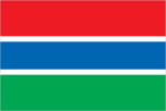
<strong>description:</strong> three equal horizontal bands of red (top), blue with white edges, and green<br><br><strong>meaning:</strong> red stands for the sun and the savannah, blue for the Gambia River, and green for forests and agriculture; the white stripes denote unity and peace
The flag of Gambia is composed of three equal horizontal bands of red, blue with white top and bottom edges, and green.
- svg
- https://flagcdn.com/gm.svg
presidential republic
18 February 1965 (from the UK)
accepts compulsory ICJ jurisdiction with reservations; accepts ICCt jurisdiction
ACP, AfDB, AU, ECOWAS, FAO, G-77, IBRD, ICAO, ICCt, ICRM, IDA, IDB, IFAD, IFC, IFRCS, ILO, IMF, IMO, Interpol, IOC, IOM, IPU, ISO (correspondent), ITSO, ITU, ITUC (NGOs), MIGA, NAM, OIC, OPCW, UN, UNAMID, UNCTAD, UNESCO, UNHRC, UNIDO, UNISFA, UNMIL, UNOCI, UNWTO, UPU, WCO, WFTU (NGOs), WHO, WIPO, WMO, WTO
- Highest court(s)
- Supreme Court of The Gambia (consists of the chief justice and 6 justices; court sessions held with 5 justices)
- Judge selection and term of office
- justices appointed by the president after consultation with the Judicial Service Commission, a 6-member independent body of high-level judicial officials, a presidential appointee, and a National Assembly appointee; justices appointed for life or until mandatory retirement at age 75
- Subordinate courts
- Court of Appeal; High Court; Special Criminal Court; Khadis or Muslim courts; district tribunals; magistrates courts; cadi courts
mixed system of English common law, Islamic law, and customary law
- Electoral system
- plurality/majority
- Expected date of next election
- April 2027
- Legislative structure
- unicameral
- Legislature name
- National Assembly
- Most recent election date
- 4/9/2022
- Number of seats
- 58 (53 directly elected; 5 appointed)
- Parties elected and seats per party
- National People's Party (NPP) (18); United Democratic Party (UDP) (15); National Reconciliation Party (NRP) (4); Independents (12); Other (4)
- Percentage of women in chamber
- 8.6%
- Scope of elections
- full renewal
- Term in office
- 5 years
red, blue, green, white
- Selected World Heritage Site locales
- Kunta Kinteh Island and Related Sites; Stone Circles of Senegambia
- Total World Heritage Sites
- 2 (both cultural)
Independence Day, 18 February (1965)
lion
Alliance for Patriotic Reorientation and Construction or APRC <br>Gambia Democratic Congress or GDC <br>Gambia Moral Congress or GMC <br>National People's Party or NPP <br>People's Progressive Party or PPP <br>United Democratic Party or UDP
Monday
18 years of age; universal
Yes
Economy
- rice, groundnuts, milk, millet, oil palm fruit, maize, vegetables, cassava, fruits, sorghum (2023)
- note
- <b>note:</b> top ten agricultural products based on tonnage
- Expenditures
- $221.137 million (2018 est.)
- Note
- <b>note:</b> central government revenues and expenses (excluding grants/extrabudgetary units/social security funds) converted to US dollars at average official exchange rate for year indicated
- Revenues
- $308.887 million (2018 est.)
- code
- GMD
- name
- dalasi (GMD) [D]
- $-99,793,232
- Current account balance 2022
- -$90.251 million (2022 est.)
- Current account balance 2023
- -$120.064 million (2023 est.)
- Current account balance 2024
- -$74.374 million (2024 est.)
- Note
- <b>note:</b> balance of payments - net trade and primary/secondary income in current dollars
- $1.64 billion
- Debt - external 2023
- $902.421 million (2023 est.)
- Note
- <b>note:</b> present value of external debt in current US dollars
low-income West African economy; agriculture-dominant; high poverty rate; heightened inflation; dependent on foreign assistance and remittances; structural reforms conditioned by IMF Extended Credit Facility program
- Currency
- dalasis (GMD) per US dollar -
- Exchange rates 2019
- 50.062 (2019 est.)
- Exchange rates 2020
- 51.502 (2020 est.)
- Exchange rates 2021
- 51.484 (2021 est.)
- Exchange rates 2022
- 54.923 (2022 est.)
- Exchange rates 2023
- 61.096 (2023 est.)
- $210.4 million
- Exports 2022
- $267.377 million (2022 est.)
- Exports 2023
- $717.774 million (2023 est.)
- Exports 2024
- $838.409 million (2024 est.)
- Note
- <b>note:</b> balance of payments - exports of goods and services in current dollars
- packaged medicine, cars, harvesting machinery, refined petroleum, trailers (2023)
- note
- <b>note:</b> top five export commodities based on value in dollars
- Kazakhstan 92%, Guinea-Bissau 2%, China 1%, India 1%, Greece 1% (2023)
- note
- <b>note:</b> top five export partners based on percentage share of exports
- net inflows
- $232.36 million
- Exports of goods and services
- 6.6% (2024 est.)
- Government consumption
- 8.5% (2024 est.)
- Household consumption
- 83.2% (2024 est.)
- Imports of goods and services
- -37.2% (2024 est.)
- Investment in fixed capital
- 39% (2024 est.)
- Investment in inventories
- 0% (2024 est.)
- Note
- <strong>note:</strong> figures may not total 100% due to rounding or gaps in data collection
- Agriculture
- 24.1% (2024 est.)
- Industry
- 14.7% (2024 est.)
- Note
- <b>note:</b> figures may not total 100% due to non-allocated consumption not captured in sector-reported data
- Services
- 53.9% (2024 est.)
- $2.508 billion (2024 est.)
- note
- <b>note:</b> data in current dollars at official exchange rate
$871
- 35.9 (2015)
- Gini Index coefficient - distribution of family income 2020
- 38.8 (2020 est.)
- Note
- <b>note:</b> index (0-100) of income distribution; higher values represent greater inequality
$2.37 billion
$880
30 % of GDP
- Highest 10%
- 30.5% (2020 est.)
- Lowest 10%
- 2.6% (2020 est.)
- Note
- <b>note:</b> % share of income accruing to lowest and highest 10% of population
- $803.76 million
- Imports 2022
- $829.516 million (2022 est.)
- Imports 2023
- $1.353 billion (2023 est.)
- Imports 2024
- $1.549 billion (2024 est.)
- Note
- <b>note:</b> balance of payments - imports of goods and services in current dollars
- crude petroleum, refined petroleum, cotton fabric, iron alloys, rice (2023)
- note
- <b>note:</b> top five import commodities based on value in dollars
- Kazakhstan 26%, China 18%, Senegal 8%, India 7%, Brazil 4% (2023)
- note
- <b>note:</b> top five import partners based on percentage share of imports
- 2.4% (2024 est.)
- note
- <b>note:</b> annual % change in industrial value added based on constant local currency
peanuts, fish, hides, tourism, beverages, agricultural machinery assembly, woodworking, metalworking, clothing
- 11.56%
- Inflation rate (consumer prices) 2022
- 11.5% (2022 est.)
- Inflation rate (consumer prices) 2023
- 17% (2023 est.)
- Inflation rate (consumer prices) 2024
- 11.6% (2024 est.)
- Note
- <b>note:</b> annual % change based on consumer prices
- 783,100 (2024 est.)
- note
- <b>note:</b> number of people ages 15 or older who are employed or seeking work
- total
- 807,275 persons
- agriculture
- 27.55%
- industry
- 18.8%
- services
- 53.64%
- 53.4% (2020 est.)
- note
- <b>note:</b> % of population with income below national poverty line
- Public debt 2016
- 82.3% of GDP (2016 est.)
- $9.59 billion
- Note
- <b>note:</b> data in 2021 dollars
- Real GDP (purchasing power parity) 2022
- $7.549 billion (2022 est.)
- Real GDP (purchasing power parity) 2023
- $7.911 billion (2023 est.)
- Real GDP (purchasing power parity) 2024
- $8.365 billion (2024 est.)
- 5.55%
- Note
- <b>note:</b> annual GDP % growth based on constant local currency
- Real GDP growth rate 2022
- 5.5% (2022 est.)
- Real GDP growth rate 2023
- 4.8% (2023 est.)
- Real GDP growth rate 2024
- 5.7% (2024 est.)
- $3,476
- Note
- <b>note:</b> data in 2021 dollars
- Real GDP per capita 2022
- $2,900 (2022 est.)
- Real GDP per capita 2023
- $2,900 (2023 est.)
- Real GDP per capita 2024
- $3,000 (2024 est.)
- $529.05 million
- Note
- <b>note:</b> personal transfers and compensation between resident and non-resident individuals/households/entities
- Remittances 2022
- 22.8% of GDP (2022 est.)
- Remittances 2023
- 21.5% of GDP (2023 est.)
- Remittances 2024
- 21.1% of GDP (2024 est.)
- $577.03 million
- Note
- <b>note:</b> holdings of gold (year-end prices)/foreign exchange/special drawing rights in current dollars
- Reserves of foreign exchange and gold 2021
- $652.671 million (2021 est.)
- Reserves of foreign exchange and gold 2022
- $568.244 million (2022 est.)
- Reserves of foreign exchange and gold 2023
- $577.028 million (2023 est.)
- 6.52%
- Note
- <b>note:</b> % of labor force seeking employment
- Unemployment rate 2022
- 6.1% (2022 est.)
- Unemployment rate 2023
- 6.5% (2023 est.)
- Unemployment rate 2024
- 6.5% (2024 est.)
- Female
- 10.9% (2024 est.)
- Male
- 10.9% (2024 est.)
- Note
- <b>note:</b> % of labor force ages 15-24 seeking employment
- Total
- 10.9% (2024 est.)
Energy
- Consumption
- 410.824 million kWh (2023 est.)
- Installed generating capacity
- 162,000 kW (2023 est.)
- Transmission/distribution losses
- 104.176 million kWh (2023 est.)
- Electrification - rural areas
- 31.2%
- Electrification - total population
- 65.4% (2022 est.)
- Electrification - urban areas
- 82.8%
- Fossil fuels
- 99% of total installed capacity (2023 est.)
- hydroelectric
- 0%
- nuclear
- 0%
- renewable
- 1.6%
- Solar
- 0.6% of total installed capacity (2023 est.)
- Wind
- 0.4% of total installed capacity (2023 est.)
- Total energy consumption per capita 2023
- 2.731 million Btu/person (2023 est.)
- Refined petroleum consumption
- 3,000 bbl/day (2023 est.)
47.7%
Communications
- per 100 inhabitants
- 0 per 100
- Subscriptions per 100 inhabitants
- (2022 est.) less than 1
- Total
- 6,000 (2022 est.)
1 state-run TV-channel; one privately owned TV station; 1 online TV station; 3 state-owned and 31 privately owned radio stations; 8 community radio stations; transmissions of multiple international broadcasters are available; cable and satellite TV subscription services in some parts of the country (2019)
.gm
- Percent of population
- 46% (2023 est.)
+220
- Subscriptions per 100 inhabitants
- 2 (2022 est.)
- Total subscriptions
- 60,000 (2021 est.)
- subscriptions per 100
- 107 per 100
- Subscriptions per 100 inhabitants
- 101 (2021 est.)
- Total subscriptions
- 2.68 million (2021 est.)
Transportation
1 (2025)
C5
Right
- By type
- general cargo 5, other 10
- Total
- 15 (2023)
- Key ports
- Banjul
- Large
- 0
- Medium
- 0
- Ports with oil terminals
- 1
- Small
- 0
- Total ports
- 1 (2024)
- Very small
- 1
WAG
Military and Security
the Gambian Armed Forces (GAF) are responsible for external defense and aiding civil authorities in internal emergencies and natural disaster relief; they participate in multinational peacekeeping missions, as well as domestic support activities such as agricultural development, construction, education, and health services; the Gambian security forces have a history of involvement in domestic politics, including multiple coup attempts and mutinies, with the latest being an attempted coup in 2022<br><br>since January 2017, several members of the Economic Community of West African States (ECOWAS) have provided security forces for Gambia's stability, plus assistance and training for the GAF and other Gambian security forces through the ECOWAS Mission in the Gambia (ECOMIG); as of 2025, Ghana, Nigeria, and Senegal were providing military and gendarmerie personnel for ECOMIG (2025)
- Gambian Armed Forces (GAF; aka Armed Forces of the Gambia): the Gambian National Army (GNA), Gambia Navy, Gambia Air Force, Republican National Guard (RNG)<br><br>Ministry of Interior: Gambia Police Force (GPF) (2025)
- active duty personnel
- 4,000
- note
- <strong>note: </strong>the RNG is responsible for VIP protection, riot control, and presidential security, while the GPF maintains internal security
- percent of total labor force
- 0.58 %
estimated 3,000-4,000 active Gambian Armed Forces (2025)
the military of Gambia has a limited inventory of mostly older, obsolescent, or donated equipment originating from several suppliers, including Taiwan, Turkey, the UK, and the US (2025)
- 1 % of GDP
- current USD
- $14,433,678
- Military Expenditures 2020
- 0.8% of GDP (2020 est.)
- Military Expenditures 2021
- 0.8% of GDP (2021 est.)
- Military Expenditures 2022
- 0.7% of GDP (2022 est.)
- Military Expenditures 2023
- 0.6% of GDP (2023 est.)
- Military Expenditures 2024
- 0.6% of GDP (2024 est.)
- percent of central government expenditure
- 2.50 %
- percent of GDP
- 0.57 % of GDP
18-28 years of age for men and women depending on enlisted, officer, or specialized positions (2025)
Transnational Issues
- IDPs
- 7,462 (2024 est.)
- Refugees
- 4,411 (2024 est.)
Environment
- From petroleum and other liquids
- 537,000 metric tonnes of CO2 (2023 est.)
- Total emissions
- 537,000 metric tonnes of CO2 (2023 est.)
deforestation due to slash-and-burn agriculture; desertification; water pollution; water-borne diseases
- Party to
- Biodiversity, Climate Change, Climate Change-Kyoto Protocol, Climate Change-Paris Agreement, Desertification, Endangered Species, Hazardous Wastes, Law of the Sea, Nuclear Test Ban, Ozone Layer Protection, Ship Pollution, Wetlands, Whaling
- Signed, but not ratified
- Comprehensive Nuclear Test Ban
34.9 micrograms per cubic meter (2019 est.)
3 % of total land area
2 % of total
8 billion cubic meters (2022 est.)
- 3 % of internal resources
- Agricultural
- 39.2 million cubic meters (2022 est.)
- Industrial
- 21.2 million cubic meters (2022 est.)
- Municipal
- 41.2 million cubic meters (2022 est.)
- Municipal solid waste generated annually
- 193,400 tons (2024 est.)
- Percent of municipal solid waste recycled
- 13% (2022 est.)