2017 Edition
CIA World Factbook 2017 Archive (HTML)
Introduction
Background
The Gambia gained its independence from the UK in 1965. Geographically surrounded by Senegal, it formed a short-lived Confederation of Senegambia between 1982 and 1989. In 1991 the two nations signed a friendship and cooperation treaty, but tensions have flared up intermittently since then. Yahya JAMMEH led a military coup in 1994 that overthrew the president and banned political activity. A new constitution and presidential election in 1996, followed by parliamentary balloting in 1997, completed a nominal return to civilian rule. JAMMEH was elected president in all subsequent elections including most recently in late 2011. After 22 years of increasingly authoritarian rule, President JAMMEH was defeated in free and fair elections in December 2016. Due to The Gambia’s poor human rights record under JAMMEH, international development partners had distanced themselves, and substantially reduced aid to the country. These channels may re-open under the administration of President
Geography
Area
- 11,300 sq km 10,120 sq km 1,180 sq km
- land
- 10,120 sq km
- total
- 11,300 sq km
- water
- 1,180 sq km
Area - comparative
slightly less than twice the size of Delaware
Climate
tropical; hot, rainy season (June to November); cooler, dry season (November to May)
Coastline
80 km
Elevation
- 34 m lowest point: Atlantic Ocean 0 m highest point: unnamed elevation 53 m
- elevation extremes
- lowest point: Atlantic Ocean 0 m
- highest point
- unnamed elevation 53 m
- mean elevation
- 34 m
Environment - current issues
deforestation; desertification; water-borne diseases prevalent
Environment - international agreements
- Biodiversity, Climate Change, Climate Change-Kyoto Protocol, Desertification, Endangered Species, Hazardous Wastes, Law of the Sea, Ozone Layer Protection, Ship Pollution, Wetlands, Whaling none of the selected agreements
- party to
- Biodiversity, Climate Change, Climate Change-Kyoto Protocol, Desertification, Endangered Species, Hazardous Wastes, Law of the Sea, Ozone Layer Protection, Ship Pollution, Wetlands, Whaling
- signed, but not ratified
- none of the selected agreements
Geographic coordinates
13 28 N, 16 34 W
Geography - note
almost an enclave of Senegal; smallest country on the African mainland
Irrigated land
50 sq km (2012)
Land boundaries
- 749 km Senegal 749 km
- border countries (1)
- Senegal 749 km
- total
- 749 km
Land use
- 56.1% arable land 41%; permanent crops 0.5%; permanent pasture 14.6% 43.9% 0% (2011 est.)
- agricultural land
- 56.1%
- forest
- 43.9%
- other
- 0% (2011 est.)
Location
Western Africa, bordering the North Atlantic Ocean and Senegal
Map references
Africa
Maritime claims
- 12 nm 18 nm 200 nm extent not specified
- contiguous zone
- 18 nm
- continental shelf
- extent not specified
- exclusive fishing zone
- 200 nm
- territorial sea
- 12 nm
Natural hazards
droughts
Natural resources
fish, clay, silica sand, titanium (rutile and ilmenite), tin, zircon
Population - distribution
settlements are found scattered along the Gambia River; the largest communities, including the capital of Banjul, and the country's largest city, Serekunda, are found at the mouth of the Gambia River along the Atlantic coast
Terrain
flood plain of the Gambia River flanked by some low hills
People and Society
Age structure
- 37.44% (male 385,646/female 382,328) 20.47% (male 207,611/female 212,366) 34.4% (male 345,788/female 359,976) 4.2% (male 41,295/female 44,865) 3.48% (male 33,153/female 38,335) (2017 est.)
- 0-14 years
- 37.44% (male 385,646/female 382,328)
- 15-24 years
- 20.47% (male 207,611/female 212,366)
- 25-54 years
- 34.4% (male 345,788/female 359,976)
- 55-64 years
- 4.2% (male 41,295/female 44,865)
- 65 years and over
- 3.48% (male 33,153/female 38,335) (2017 est.)
Birth rate
29.4 births/1,000 population (2017 est.)
Children under the age of 5 years underweight
16.4% (2013)
Contraceptive prevalence rate
9% (2013)
Death rate
7 deaths/1,000 population (2017 est.)
Demographic profile
The Gambia’s youthful age structure – almost 60% of the population is under the age of 25 – is likely to persist because the country’s total fertility rate remains strong at nearly 4 children per woman. The overall literacy rate is around 55%, and is significantly lower for women than for men. At least 70% of the populace are farmers who are reliant on rain-fed agriculture and cannot afford improved seeds and fertilizers. Crop failures caused by droughts between 2011 and 2013 have increased poverty, food shortages, and malnutrition. The Gambia is a source country for migrants and a transit and destination country for migrants and refugees. Since the 1980s, economic deterioration, drought, and high unemployment, especially among youths, have driven both domestic migration (largely urban) and migration abroad (legal and illegal). Emigrants are largely skilled workers, including doctors and nurses, and provide a significant amount of remittances. The top receiving countries for Gambian emigrants are Spain, the US, Nigeria, Senegal, and the UK. While the Gambia and Spain do not share historic, cultural, or trade ties, rural Gambians have migrated to Spain in large numbers because of its proximity and the availability of jobs in its underground economy (this flow slowed following the onset of Spain’s late 2007 economic crisis). The Gambia’s role as a host country to refugees is a result of wars in several of its neighboring West African countries. Since 2006, refugees from the Casamance conflict in Senegal have replaced their pattern of flight and return with permanent settlement in The Gambia, often moving in with relatives along the Senegal-Gambia border. The strain of providing for about 7,400 Casamance refugees has increased poverty among Gambian villagers.
Dependency ratios
- 92.3 87.8 4.5 22.3 (2015 est.)
- elderly dependency ratio
- 4.5
- potential support ratio
- 22.3 (2015 est.)
- total dependency ratio
- 92.3
- youth dependency ratio
- 87.8
Drinking water source
- urban: 94.2% of population rural: 84.4% of population total: 90.2% of population urban: 5.8% of population rural: 15.6% of population total: 9.8% of population (2015 est.)
- rural
- 15.6% of population
- total
- 9.8% of population (2015 est.)
- urban
- 5.8% of population
Education expenditures
2.8% of GDP (2013)
Ethnic groups
Mandinka/Jahanka 34%, Fulani/Tukulur/Lorobo 22.4%, Wolof 12.6%, Jola/Karoninka 10.7%, Serahuleh 6.6%, Serer 3.2%, Manjago 2.1%, Bambara 1%, Creole/Aku Marabout 0.7%, other 0.9%, non-Gambian 5.2%, no answer 0.6% (2013 est.)
Health expenditures
7.3% of GDP (2014)
HIV/AIDS - adult prevalence rate
1.7% (2016 est.)
HIV/AIDS - deaths
1,100 (2016 est.)
HIV/AIDS - people living with HIV/AIDS
20,000 (2016 est.)
Hospital bed density
1.1 beds/1,000 population (2011)
Infant mortality rate
- 60.2 deaths/1,000 live births 65.6 deaths/1,000 live births 54.7 deaths/1,000 live births (2017 est.)
- female
- 54.7 deaths/1,000 live births (2017 est.)
- male
- 65.6 deaths/1,000 live births
- total
- 60.2 deaths/1,000 live births
Languages
English (official), Mandinka, Wolof, Fula, other indigenous vernaculars
Life expectancy at birth
- 65.1 years 62.8 years 67.5 years (2017 est.)
- female
- 67.5 years (2017 est.)
- male
- 62.8 years
- total population
- 65.1 years
Literacy
- age 15 and over can read and write 55.5% 63.9% 47.6% (2015 est.)
- definition
- age 15 and over can read and write
- female
- 47.6% (2015 est.)
- male
- 63.9%
- total population
- 55.5%
Major infectious diseases
- very high bacterial and protozoal diarrhea, hepatitis A, and typhoid fever malaria and dengue fever schistosomiasis meningococcal meningitis rabies (2016)
- animal contact disease
- rabies (2016)
- degree of risk
- very high
- food or waterborne diseases
- bacterial and protozoal diarrhea, hepatitis A, and typhoid fever
- respiratory disease
- meningococcal meningitis
- vectorborne diseases
- malaria and dengue fever
- water contact disease
- schistosomiasis
Major urban areas - population
BANJUL (capital) 504,000 (2015)
Maternal mortality rate
706 deaths/100,000 live births (2015 est.)
Median age
- 21 years 20.7 years 21.3 years (2017 est.)
- female
- 21.3 years (2017 est.)
- male
- 20.7 years
- total
- 21 years
Mother's mean age at first birth
- 20.9 years median age at first birth among women 25-29 (2013 est.)
- note
- median age at first birth among women 25-29 (2013 est.)
Nationality
- Gambian(s) Gambian
- adjective
- Gambian
- noun
- Gambian(s)
Net migration rate
-1.9 migrant(s)/1,000 population (2017 est.)
Obesity - adult prevalence rate
10.3% (2016)
Physicians density
0.11 physicians/1,000 population (2008)
Population
2,051,363 (July 2017 est.)
Population distribution
settlements are found scattered along the Gambia River; the largest communities, including the capital of Banjul, and the country's largest city, Serekunda, are found at the mouth of the Gambia River along the Atlantic coast
Population growth rate
2.05% (2017 est.)
Religions
Muslim 95.7%, Christian 4.2%, none 0.1%, no answer 0.1% (2013 est.)
Sanitation facility access
- urban: 61.5% of population rural: 55% of population total: 58.9% of population urban: 38.5% of population rural: 45% of population total: 41.1% of population (2015 est.)
- rural
- 45% of population
- total
- 41.1% of population (2015 est.)
- urban
- 38.5% of population
School life expectancy (primary to tertiary education)
- 9 years 9 years 9 years (2010)
- female
- 9 years (2010)
- male
- 9 years
- total
- 9 years
Sex ratio
- 1.03 male(s)/female 1.01 male(s)/female 0.98 male(s)/female 0.96 male(s)/female 0.93 male(s)/female 0.88 male(s)/female 0.98 male(s)/female (2016 est.)
- 0-14 years
- 1.01 male(s)/female
- 15-24 years
- 0.98 male(s)/female
- 25-54 years
- 0.96 male(s)/female
- 55-64 years
- 0.93 male(s)/female
- 65 years and over
- 0.88 male(s)/female
- at birth
- 1.03 male(s)/female
- total population
- 0.98 male(s)/female (2016 est.)
Total fertility rate
3.52 children born/woman (2017 est.)
Unemployment, youth ages 15-24
- 44.3% 38.1% 49.5% (2012 est.)
- female
- 49.5% (2012 est.)
- male
- 38.1%
- total
- 44.3%
Urbanization
- 60.8% of total population (2017) 3.96% annual rate of change (2015-20 est.)
- rate of urbanization
- 3.96% annual rate of change (2015-20 est.)
- urban population
- 60.8% of total population (2017)
Government
Administrative divisions
5 regions, 1 city*, and 1 municipality**; Banjul*, Central River, Kanifing**, Lower River, North Bank, Upper River, West Coast
Capital
- Banjul 13 27 N, 16 34 W UTC 0 (5 hours ahead of Washington, DC, during Standard Time)
- geographic coordinates
- 13 27 N, 16 34 W
- name
- Banjul
- time difference
- UTC 0 (5 hours ahead of Washington, DC, during Standard Time)
Citizenship
- yes yes no 5 years
- citizenship by birth
- yes
- citizenship by descent
- yes
- dual citizenship recognized
- no
- residency requirement for naturalization
- 5 years
Constitution
- previous 1965 (independence act), 1970; latest adopted 8 April 1996, approved by referendum 8 August 1996, effective 16 January 1997 proposed by the National Assembly; passage requires at least three-fourths majority vote by the Assembly membership in each of several readings and approval by the president of the republic; a referendum is required for amendments affecting national sovereignty, fundamental rights and freedoms, government structures and authorities, taxation, and public funding; passage by referendum requires participation of at least 50% of eligible voters and approval by at least 75% of votes cast; amended 2001, 2004, 2010 (2017)
- amendments
- proposed by the National Assembly; passage requires at least three-fourths majority vote by the Assembly membership in each of several readings and approval by the president of the republic; a referendum is required for amendments affecting national sovereignty, fundamental rights and freedoms, government structures and authorities, taxation, and public funding; passage by referendum requires participation of at least 50% of eligible voters and approval by at least 75% of votes cast; amended 2001, 2004, 2010 (2017)
- history
- previous 1965 (independence act), 1970; latest adopted 8 April 1996, approved by referendum 8 August 1996, effective 16 January 1997
Country name
- Republic of The Gambia The Gambia named for the Gambia River that flows through the heart of the country
- conventional long form
- Republic of The Gambia
- conventional short form
- The Gambia
- etymology
- named for the Gambia River that flows through the heart of the country
Diplomatic representation from the US
- Ambassador C. Patricia ALSUP (since 11 January 2016) Kairaba Avenue, Fajara, Banjul P.M.B. 19, Banjul [220] 439-2856 [220] 439-2475
- chief of mission
- Ambassador C. Patricia ALSUP (since 11 January 2016)
- embassy
- Kairaba Avenue, Fajara, Banjul
- FAX
- [220] 439-2475
- mailing address
- P.M.B. 19, Banjul
- telephone
- [220] 439-2856
Diplomatic representation in the US
- Ambassador (vacant); Charge d'Affaires Manneh HAMBA (since 3 May 2017) 2233 Wisconsin Avenue NW, Georgetown Plaza, Suite 240, Washington, DC 20007 [1] (202) 785-1379, 1399, 1425 [1] (202) 342-0240
- chancery
- 2233 Wisconsin Avenue NW, Georgetown Plaza, Suite 240, Washington, DC 20007
- chief of mission
- Ambassador (vacant); Charge d'Affaires Manneh HAMBA (since 3 May 2017)
- FAX
- [1] (202) 342-0240
- telephone
- [1] (202) 785-1379, 1399, 1425
Executive branch
- President Adama BARROW (since 19 January 2017); Vice President Fatoumata JALLOW-TAMBAJANG (since 23 January 2017); note - the president is both chief of state and head of government President Adama BARROW (since 19 January 2017); Vice President Fatoumata JALLOW-TAMBAJANG (since 23 January 2017) Cabinet appointed by the president president directly elected by simple majority popular vote for a 5-year term (no term limits); election last held on 24 November 2011 (next to be held on 1 December 2016); vice president appointed by the president Adama BARROW elected president; percent of vote - Adama BARROW (Coalition 2016) 43.3%, Yahya JAMMEH (APRC)39.6%, Mamma KANDEH (GDC) 17.1%
- cabinet
- Cabinet appointed by the president
- chief of state
- President Adama BARROW (since 19 January 2017); Vice President Fatoumata JALLOW-TAMBAJANG (since 23 January 2017); note - the president is both chief of state and head of government
- election results
- Adama BARROW elected president; percent of vote - Adama BARROW (Coalition 2016) 43.3%, Yahya JAMMEH (APRC)39.6%, Mamma KANDEH (GDC) 17.1%
- elections/appointments
- president directly elected by simple majority popular vote for a 5-year term (no term limits); election last held on 24 November 2011 (next to be held on 1 December 2016); vice president appointed by the president
- head of government
- President Adama BARROW (since 19 January 2017); Vice President Fatoumata JALLOW-TAMBAJANG (since 23 January 2017)
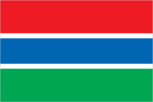
Flag description
three equal horizontal bands of red (top), blue with white edges, and green; red stands for the sun and the savannah, blue represents the Gambia River, and green symbolizes forests and agriculture; the white stripes denote unity and peace
Government type
presidential republic
Independence
18 February 1965 (from the UK)
International law organization participation
accepts compulsory ICJ jurisdiction with reservations; accepts ICCt jurisdiction
International organization participation
ACP, AfDB, AU, ECOWAS, FAO, G-77, IBRD, ICAO, ICCt, ICRM, IDA, IDB, IFAD, IFC, IFRCS, ILO, IMF, IMO, Interpol, IOC, IOM, IPU, ISO (correspondent), ITSO, ITU, ITUC (NGOs), MIGA, MINUSMA, NAM, OIC, OPCW, UN, UNAMID, UNCTAD, UNESCO, UNIDO, UNMIL, UNOCI, UNWTO, UPU, WCO, WFTU (NGOs), WHO, WIPO, WMO, WTO
Judicial branch
- Supreme Court of The Gambia (consists of the chief justice and 6 justices; court sessions held with 5 justices) justices appointed by the president after consultation with the Judicial Service Commission, a 6-member independent body of high-level judicial officials, a presidential appointee, and a National Assembly appointee; justices appointed for life or until mandatory retirement age Court of Appeal; High Court; Special Criminal Court; Khadis or Muslim courts; district tribunals; magistrates courts
- highest court(s)
- Supreme Court of The Gambia (consists of the chief justice and 6 justices; court sessions held with 5 justices)
- judge selection and term of office
- justices appointed by the president after consultation with the Judicial Service Commission, a 6-member independent body of high-level judicial officials, a presidential appointee, and a National Assembly appointee; justices appointed for life or until mandatory retirement age
- subordinate courts
- Court of Appeal; High Court; Special Criminal Court; Khadis or Muslim courts; district tribunals; magistrates courts
Legal system
mixed legal system of English common law, Islamic law, and customary law
Legislative branch
- unicameral National Assembly (58 seats; 53 members directly elected in single-seat constituencies by simple majority vote and 5 appointed by the president; members serve 5-year terms) last held on 6 April 2017 (next to be held in 2022) percent of vote by party - UDP 37.5%, GDC 17.4%, APRC 16%, PDOIS 9%, NRP 6.3%, PPP 2.5%, independent 9.6%; seats by party - UDP 31, APRC 5, GDC 5, NRP 5, PDOIS 4, PPP 2, independent 1
- description
- unicameral National Assembly (58 seats; 53 members directly elected in single-seat constituencies by simple majority vote and 5 appointed by the president; members serve 5-year terms)
- election results
- percent of vote by party - UDP 37.5%, GDC 17.4%, APRC 16%, PDOIS 9%, NRP 6.3%, PPP 2.5%, independent 9.6%; seats by party - UDP 31, APRC 5, GDC 5, NRP 5, PDOIS 4, PPP 2, independent 1
- elections
- last held on 6 April 2017 (next to be held in 2022)
National anthem
- "For The Gambia, Our Homeland" Virginia Julie HOWE/adapted by Jeremy Frederick HOWE adopted 1965; the music is an adaptation of the traditional Mandinka song "Foday Kaba Dumbuya"
- lyrics/music
- Virginia Julie HOWE/adapted by Jeremy Frederick HOWE
- name
- "For The Gambia, Our Homeland"
- note
- adopted 1965; the music is an adaptation of the traditional Mandinka song "Foday Kaba Dumbuya"
National holiday
Independence Day, 18 February (1965)
National symbol(s)
- lion; national colors: red, blue, green, white
- lion; national colors
- red, blue, green, white
Political parties and leaders
Alliance for Patriotic Reorientation and Construction or APRC [Fabakary JATTA] Coalition 2016 [collective leadership] (electoral coalition including UDP, PDOIS, NRP, GMC, GDC, PPP, GPDP) Gambia Democratic Congress or GDC [Mama KANDEH] Gambia Moral Congress or GMC [Mai FATTY] Gambia Party for Democracy and Progress or GPDP [Henry GOMEZ] National Reconciliation Party or NRP [Samba JALLOW] National Convention Party or NCP [Ebrima Janko SANYANG] People's Democratic Organization for Independence and Socialism or PDOIS [Sidia JATTA] People's Progressive Party or PPP [Yaya CEESAY)] United Democratic Party or UDP [Ousainou DARBOE]
Political pressure groups and leaders
- The Association of Non-Governmental Organizations or TANGO Female Lawyers Association of Gambia or FLAG Gambia Committee on Traditional Practices or GAMCOTRAP Gambia Press Union or GPU West African Peace Building Network-Gambian Chapter or WANEB-GAMBIA Youth Employment Network Gambia or YENGambia special needs group advocates; teachers and principals
- other
- special needs group advocates; teachers and principals
Suffrage
18 years of age; universal
Economy
Agriculture - products
rice, millet, sorghum, peanuts, corn, sesame, cassava (manioc, tapioca), palm kernels; cattle, sheep, goats
Budget
- $192.9 million $380.6 million (2016 est.)
- expenditures
- $380.6 million (2016 est.)
- revenues
- $192.9 million
Budget surplus (+) or deficit (-)
-19.5% of GDP (2016 est.)
Central bank discount rate
9% (31 December 2009) 11% (31 December 2008)
Commercial bank prime lending rate
30.4% (31 December 2016 est.) 30.1% (31 December 2015 est.)
Current account balance
$-86 million (2016 est.) $-131.7 million (2015 est.)
Debt - external
- $571.2 million (31 December 2016 est.) $526.7 million (31 December 2015 est.)
- g
- $571.2 million (31 December 2016 est.)
Distribution of family income - Gini index
50.2 (1998)
Economy - overview
The government has invested in the agriculture sector because three-quarters of the population depends on the sector for its livelihood and agriculture provides for about one-third of GDP, making The Gambia largely reliant on sufficient rainfall. The agricultural sector has untapped potential - less than half of arable land is cultivated and agricultural productivity is low. Small-scale manufacturing activity features the processing of cashews, groundnuts, fish, and hides. The Gambia's reexport trade accounts for almost 80% of goods exports and China has been its largest trade partner for both exports and imports for several years. The Gambia has sparse natural resource deposits. It relies heavily on remittances from workers overseas and tourist receipts. Remittance inflows to The Gambia amount to about one-fifth of the country’s GDP. The Gambia's location on the ocean and proximity to Europe has made it one of the most frequented tourist destinations in West Africa, boosted by private sector investments in eco-tourism and facilities. Tourism normally brings in about 20% of GDP, but it suffered in 2014 from tourists’ fears of Ebola virus in neighboring West African countries. Unemployment and underemployment remain high. Economic progress depends on sustained bilateral and multilateral aid, on responsible government economic management, and on continued technical assistance from multilateral and bilateral donors. International donors and lenders were concerned about the quality of fiscal management under the administration of former President Yahya JAMMEH, who reportedly stole hundreds of millions of dollars of the country’s funds during his 22 years in power, but anticipate significant improvements under the new administration of President Adama BARROW, who assumed power in early 2017. As of April 2017, the IMF, the World Bank, the European Union, and the African Development Bank were all negotiating with the new government of The Gambia to provide financial support in the coming months to ease the country’s financial crisis. The country’s GDP contracted in 2016 largely as a result of the limited availability of foreign exchange, weak agricultural output, the border closure with Senegal during the first half of the year, and a slowdown in tourism during the political impasse that occurred at the height of the tourist season. The country faces a large fiscal deficit and a high domestic debt burden that has crowded out private sector investment and driven interest rates to new highs. The new government has committed to taking steps to reduce the deficit, including through expenditure caps, debt consolidation, and reform of state-owned enterprises.
Exchange rates
dalasis (GMD) per US dollar - 43.8846 (2016 est.) 43.8846 (2015 est.) 41.89 (2014 est.) 41.733 (2013 est.) 32.08 (2012 est.)
Exports
$106.6 million (2016 est.) $108.3 million (2015 est.)
Exports - commodities
peanut products, fish, cotton lint, palm kernels
Exports - partners
Mali 36.3%, Guinea 24.5%, Senegal 12.3%, China 11.7%, Guinea-Bissau 5.8% (2016)
Fiscal year
calendar year
GDP - composition, by end use
- 86.3% 10.4% 19.9% -7% 19.9% -29.5% (2016 est.)
- exports of goods and services
- 19.9%
- government consumption
- 10.4%
- household consumption
- 86.3%
- imports of goods and services
- -29.5% (2016 est.)
- investment in fixed capital
- 19.9%
- investment in inventories
- -7%
GDP - composition, by sector of origin
- 21% 13.8% 65.2% (2016 est.)
- agriculture
- 21%
- industry
- 13.8%
- services
- 65.2% (2016 est.)
GDP - per capita (PPP)
- $1,700 (2016 est.) $1,700 (2015 est.) $1,700 (2014 est.) data are in 2016 dollars
- note
- data are in 2016 dollars
GDP - real growth rate
2.2% (2016 est.) 4.3% (2015 est.) 0.9% (2014 est.)
GDP (official exchange rate)
$965 million (2016 est.)
GDP (purchasing power parity)
- $3.418 billion (2016 est.) $3.302 billion (2015 est.) $3.132 billion (2014 est.) data are in 2016 dollars
- note
- data are in 2016 dollars
Gross national saving
9.8% of GDP (2016 est.) 4.7% of GDP (2015 est.) 10.1% of GDP (2014 est.)
Household income or consumption by percentage share
- 2% 36.9% (2003)
- highest 10%
- 36.9% (2003)
- lowest 10%
- 2%
Imports
$326.7 million (2016 est.) $370.2 million (2015 est.)
Imports - commodities
foodstuffs, manufactures, fuel, machinery and transport equipment
Imports - partners
Cote dIvoire 13%, Brazil 12.3%, China 11%, Belgium 8.6%, India 5.7%, Spain 4.7%, Senegal 4.6% (2016)
Industrial production growth rate
-6.1% (2016 est.)
Industries
peanuts, fish, hides, tourism, beverages, agricultural machinery assembly, woodworking, metalworking, clothing
Inflation rate (consumer prices)
7.2% (2016 est.) 6.8% (2015 est.)
Labor force
777,100 (2007 est.)
Labor force - by occupation
- 75% 19% 6% (1996)
- agriculture
- 75%
- industry
- 19%
- services
- 6% (1996)
Market value of publicly traded shares
$NA
Population below poverty line
48.4% (2010 est.)
Public debt
116.1% of GDP (2016 est.) 110.2% of GDP (2015 est.)
Reserves of foreign exchange and gold
$87.64 million (31 December 2016 est.) $111 million (31 December 2015 est.)
Stock of broad money
$529.9 million (31 December 2016 est.) $507.4 million (31 December 2015 est.)
Stock of domestic credit
$496.7 million (31 December 2016 est.) $475.2 million (31 December 2015 est.)
Stock of narrow money
$279.6 million (31 December 2016 est.) $261.2 million (31 December 2015 est.)
Taxes and other revenues
20% of GDP (2016 est.)
Unemployment rate
NA%
Energy
Carbon dioxide emissions from consumption of energy
500,000 Mt (2013 est.)
Crude oil - exports
0 bbl/day (2014 est.)
Crude oil - imports
0 bbl/day (2014 est.)
Crude oil - production
0 bbl/day (2016 est.)
Crude oil - proved reserves
0 bbl (1 January 2017 es)
Electricity - consumption
223.2 million kWh (2015 est.)
Electricity - exports
0 kWh (2016 est.)
Electricity - from fossil fuels
100% of total installed capacity (2015 est.)
Electricity - from hydroelectric plants
0% of total installed capacity (2015 est.)
Electricity - from nuclear fuels
0% of total installed capacity (2015 est.)
Electricity - from other renewable sources
0% of total installed capacity (2015 est.)
Electricity - imports
0 kWh (2016 est.)
Electricity - installed generating capacity
114,000 kW (2015 est.)
Electricity - production
240 million kWh (2015 est.)
Electricity access
- 1,200,000 36% 60% 2% (2013)
- electrification - rural areas
- 2% (2013)
- electrification - total population
- 36%
- electrification - urban areas
- 60%
- population without electricity
- 1,200,000
Natural gas - consumption
0 cu m (2013 est.)
Natural gas - exports
0 cu m (2013 est.)
Natural gas - imports
0 cu m (2013 est.)
Natural gas - production
0 cu m (2013 est.)
Natural gas - proved reserves
0 cu m (1 January 2014 es)
Refined petroleum products - consumption
3,600 bbl/day (2015 est.)
Refined petroleum products - exports
41.62 bbl/day (2014 est.)
Refined petroleum products - imports
3,552 bbl/day (2014 est.)
Refined petroleum products - production
0 bbl/day (2014 est.)
Communications
Broadcast media
state-owned, single-channel TV service; state-owned radio station and 15 privately owned radio stations; 6 community radio stations; transmissions of multiple international broadcasters are available, some via shortwave radio; cable and satellite TV subscription services are obtainable in some parts of the country (2015)
Internet country code
.gm
Internet users
- 371,785 18.5% (July 2016 est.)
- percent of population
- 18.5% (July 2016 est.)
- total
- 371,785
Telephone system
- adequate microwave radio relay and open-wire network; state-owned Gambia Telecommunications partially privatized in 2007 combined fixed-line and mobile-cellular teledensity, aided by multiple mobile-cellular providers, is over 140 per 100 persons country code - 220; microwave radio relay links to Senegal and Guinea-Bissau; a landing station for the Africa Coast to Europe (ACE) undersea fiber-optic cable completed in 2011 and launched in 2012; satellite earth station - 1 Intelsat (Atlantic Ocean) (2016)
- domestic
- combined fixed-line and mobile-cellular teledensity, aided by multiple mobile-cellular providers, is over 140 per 100 persons
- general assessment
- adequate microwave radio relay and open-wire network; state-owned Gambia Telecommunications partially privatized in 2007
- international
- country code - 220; microwave radio relay links to Senegal and Guinea-Bissau; a landing station for the Africa Coast to Europe (ACE) undersea fiber-optic cable completed in 2011 and launched in 2012; satellite earth station - 1 Intelsat (Atlantic Ocean) (2016)
Telephones - fixed lines
- 37,969 2 (July 2016 est.)
- subscriptions per 100 inhabitants
- 2 (July 2016 est.)
- total subscriptions
- 37,969
Telephones - mobile cellular
- 2,838,127 141 (July 2016 est.)
- subscriptions per 100 inhabitants
- 141 (July 2016 est.)
- total
- 2,838,127
Transportation
Airports
1 (2013)
Airports - with paved runways
- 1 (2017)
- over 3,047 m
- 1 (2017)
- total
- 1
Civil aircraft registration country code prefix
C5 (2016)
Merchant marine
- passenger/cargo 3, petroleum tanker 1 (2010)
- by type
- passenger/cargo 3, petroleum tanker 1 (2010)
- total
- 4
Ports and terminals
- Banjul
- major seaport(s)
- Banjul
Roadways
- 3,740 km 711 km 3,029 km (2011)
- paved
- 711 km
- total
- 3,740 km
- unpaved
- 3,029 km (2011)
Waterways
390 km (on River Gambia; small oceangoing vessels can reach 190 km) (2010)
Military and Security
Military branches
- Office of the Chief of Defense Staff: Gambian National Army (GNA), Gambian Navy (GN), Republican National Guard (RNG) (2010)
- Office of the Chief of Defense Staff
- Gambian National Army (GNA), Gambian Navy (GN), Republican National Guard (RNG) (2010)
Military expenditures
1.48% of GDP (2015) 1.72% of GDP (2014) 1.15% of GDP (2013) 1.22% of GDP (2012)
Military service age and obligation
18 years of age for male and female voluntary military service; no conscription; service obligation 6 months (2012)
Transnational Issues
Disputes - international
attempts to stem refugees, cross-border raids, arms smuggling, and other illegal activities by separatists from southern Senegal's Casamance region, as well as from conflicts in other west African states
Refugees and internally displaced persons
- 7,530 (Senegal) (2017)
- refugees (country of origin)
- 7,530 (Senegal) (2017)
Trafficking in persons
- The Gambia is a source and destination country for women and children subjected to forced labor and sex trafficking; Gambian women, girls, and, to a lesser extent, boys are exploited for prostitution and domestic servitude; women, girls, and boys from West African countries are trafficked to The Gambia for commercial sexual exploitation, particularly by European sex tourists; boys in some Koranic schools are forced into street vending or begging; some Gambian children have been identified as victims of forced labor in neighboring West African countries Tier 3 – The Gambia does not fully comply with the minimum standards for the elimination of trafficking and is not making significant efforts to do so; the government demonstrated minimal anti-trafficking law enforcement efforts, investigating one trafficking case but not prosecuting or convicting any offenders in 2014; authorities did not investigate, prosecute, or convict any government employees complicit in trafficking, although corruption was a serious problem; the government identified and repatriated 19 Gambian girls subjected to domestic servitude in Lebanon but did not identify or provide protective services to any trafficking victims in The Gambia; a government program continued to provide resources and financial support to 12 Koranic schools on the condition that their students were not forced to beg (2015)
- current situation
- The Gambia is a source and destination country for women and children subjected to forced labor and sex trafficking; Gambian women, girls, and, to a lesser extent, boys are exploited for prostitution and domestic servitude; women, girls, and boys from West African countries are trafficked to The Gambia for commercial sexual exploitation, particularly by European sex tourists; boys in some Koranic schools are forced into street vending or begging; some Gambian children have been identified as victims of forced labor in neighboring West African countries
- tier rating
- Tier 3 – The Gambia does not fully comply with the minimum standards for the elimination of trafficking and is not making significant efforts to do so; the government demonstrated minimal anti-trafficking law enforcement efforts, investigating one trafficking case but not prosecuting or convicting any offenders in 2014; authorities did not investigate, prosecute, or convict any government employees complicit in trafficking, although corruption was a serious problem; the government identified and repatriated 19 Gambian girls subjected to domestic servitude in Lebanon but did not identify or provide protective services to any trafficking victims in The Gambia; a government program continued to provide resources and financial support to 12 Koranic schools on the condition that their students were not forced to beg (2015)