2015 Edition
CIA World Factbook 2015 Archive (Wayback Machine ZIP)
Introduction
Background
The Gambia gained its independence from the UK in 1965. Geographically surrounded by Senegal, it formed a short-lived Confederation of Senegambia between 1982 and 1989. In 1991 the two nations signed a friendship and cooperation treaty, but tensions have flared up intermittently since then. Yahya JAMMEH led a military coup in 1994 that overthrew the president and banned political activity. A new constitution and presidential election in 1996, followed by parliamentary balloting in 1997, completed a nominal return to civilian rule. JAMMEH was elected president in all subsequent elections including most recently in late 2011.
Geography
Area
- land
- 10,120 sq km
- total
- 11,300 sq km
- water
- 1,180 sq km
Area - comparative
slightly less than twice the size of Delaware
Climate
tropical; hot, rainy season (June to November); cooler, dry season (November to May)
Coastline
80 km
Elevation extremes
- highest point
- unnamed elevation 53 m
- lowest point
- Atlantic Ocean 0 m
Environment - current issues
deforestation; desertification; water-borne diseases prevalent
Environment - international agreements
- party to
- Biodiversity, Climate Change, Climate Change-Kyoto Protocol, Desertification, Endangered Species, Hazardous Wastes, Law of the Sea, Ozone Layer Protection, Ship Pollution, Wetlands, Whaling
- signed, but not ratified
- none of the selected agreements
Freshwater withdrawal (domestic/industrial/agricultural)
- per capita
- 65.77 cu m/yr (2005)
- total
- 0.09 cu km/yr (41%/21%/39%)
Geographic coordinates
13 28 N, 16 34 W
Geography - note
almost an enclave of Senegal; smallest country in Africa
Irrigated land
50 sq km (2011)
Land boundaries
- border countries (1)
- Senegal 749 km
- total
- 749 km
Land use
- arable land 41%; permanent crops 0.5%; permanent pasture 14.6%
- agricultural land
- 56.1%
- forest
- 43.9%
- other
- 0% (2011 est.)
Location
Western Africa, bordering the North Atlantic Ocean and Senegal
Map references
Africa
Maritime claims
- contiguous zone
- 18 nm
- continental shelf
- extent not specified
- exclusive fishing zone
- 200 nm
- territorial sea
- 12 nm
Natural hazards
drought (rainfall has dropped by 30% in the last 30 years)
Natural resources
fish, clay, silica sand, titanium (rutile and ilmenite), tin, zircon
Terrain
flood plain of the Gambia River flanked by some low hills
Total renewable water resources
8 cu km (2011)
People and Society
Age structure
- 0-14 years
- 38.31% (male 378,449/female 375,417)
- 15-24 years
- 20.81% (male 202,218/female 207,194)
- 25-54 years
- 33.45% (male 322,250/female 335,860)
- 55-64 years
- 4.08% (male 38,717/female 41,532)
- 65 years and over
- 3.36% (male 30,886/female 35,186) (2015 est.)
Birth rate
30.86 births/1,000 population (2015 est.)
Child labor - children ages 5-14
- percentage
- 25% (2006 est.)
- total number
- 103,389
Children under the age of 5 years underweight
17.4% (2010)
Contraceptive prevalence rate
9% (2013)
Death rate
7.15 deaths/1,000 population (2015 est.)
Dependency ratios
- elderly dependency ratio
- 4.5%
- potential support ratio
- 22.3% (2015 est.)
- total dependency ratio
- 94.2%
- youth dependency ratio
- 89.7%
Drinking water source
- urban: 94.2% of population
- rural: 84.4% of population
- total: 90.2% of population
- urban: 5.8% of population
- rural: 15.6% of population
- total: 9.8% of population (2015 est.)
Education expenditures
4.1% of GDP (2012)
Ethnic groups
African 99% (Mandinka 42%, Fula 18%, Wolof 16%, Jola 10%, Serahuli 9%, other 4%), non-African 1% (2003 census)
Health expenditures
6% of GDP (2013)
HIV/AIDS - adult prevalence rate
1.82% (2014 est.)
HIV/AIDS - deaths
900 (2014 est.)
HIV/AIDS - people living with HIV/AIDS
20,300 (2014 est.)
Hospital bed density
1.1 beds/1,000 population (2011)
Infant mortality rate
- female
- 58.3 deaths/1,000 live births (2015 est.)
- male
- 69.33 deaths/1,000 live births
- total
- 63.9 deaths/1,000 live births
Languages
English (official), Mandinka, Wolof, Fula, other indigenous vernaculars
Life expectancy at birth
- female
- 67 years (2015 est.)
- male
- 62.27 years
- total population
- 64.6 years
Literacy
- definition
- age 15 and over can read and write
- female
- 47.6% (2015 est.)
- male
- 63.9%
- total population
- 55.5%
Major infectious diseases
- animal contact disease
- rabies (2013)
- degree of risk
- very high
- food or waterborne diseases
- bacterial and protozoal diarrhea, hepatitis A, and typhoid fever
- respiratory disease
- meningococcal meningitis
- vectorborne diseases
- malaria and dengue fever
- water contact disease
- schistosomiasis
Major urban areas - population
BANJUL (capital) 504,000 (2015)
Median age
- female
- 20.8 years (2015 est.)
- male
- 20.2 years
- total
- 20.5 years
Nationality
- adjective
- Gambian
- noun
- Gambian(s)
Net migration rate
-2.12 migrant(s)/1,000 population (2015 est.)
Obesity - adult prevalence rate
9.1% (2014)
Physicians density
0.11 physicians/1,000 population (2008)
Population
1,967,709 (July 2015 est.)
Population growth rate
2.16% (2015 est.)
Religions
Muslim 90%, Christian 8%, indigenous beliefs 2%
Sanitation facility access
- urban: 61.5% of population
- rural: 55% of population
- total: 58.9% of population
- urban: 38.5% of population
- rural: 45% of population
- total: 41.1% of population (2015 est.)
School life expectancy (primary to tertiary education)
- female
- 9 years (2010)
- male
- 9 years
- total
- 9 years
Sex ratio
- 0-14 years
- 1.01 male(s)/female
- 15-24 years
- 0.98 male(s)/female
- 25-54 years
- 0.96 male(s)/female
- 55-64 years
- 0.93 male(s)/female
- 65 years and over
- 0.88 male(s)/female
- at birth
- 1.03 male(s)/female
- total population
- 0.98 male(s)/female (2015 est.)
Total fertility rate
3.73 children born/woman (2015 est.)
Urbanization
- rate of urbanization
- 4.33% annual rate of change (2010-15 est.)
- urban population
- 59.6% of total population (2015)
Government
Administrative divisions
5 divisions and 1 city*; Banjul*, Central River, Lower River, North Bank, Upper River, Western
Capital
- geographic coordinates
- 13 27 N, 16 34 W
- name
- Banjul
- time difference
- UTC 0 (5 hours ahead of Washington, DC, during Standard Time)
Constitution
previous 1970; latest adopted 8 April 1996, approved by referendum 8 August 1996, effective 16 January 1997; amended several times, last in 2009 (2009)
Country name
- conventional long form
- Republic of The Gambia
- conventional short form
- The Gambia
Diplomatic representation from the US
- chief of mission
- Ambassador (vacant); Deputy Chief of Mission Richard T. YONEOKA (since August 2014); note - Ambassador George Staples serves as Charge d'Affaires, but is an adjunct professor at the University of Kentucky
- embassy
- Kairaba Avenue, Fajara, Banjul
- FAX
- [220] 439-2475
- mailing address
- P. M. B. No. 19, Banjul
- telephone
- [220] 439-2856, 437-6169, 437-6170
Diplomatic representation in the US
- chancery
- 2233 Wisconsin Avenue NW, Georgetown Plaza, Suite 240, Washington, DC 20007
- chief of mission
- Ambassador Sheikh Amar FAYE (since 3 August 2015)
- FAX
- [1] (202) 342-0240
- telephone
- [1] (202) 785-1379, 1399, 1425 [1] (202) 785-1379, 1399, 1425
Executive branch
- cabinet
- Cabinet appointed by the president
- chief of state
- President Yahya JAMMEH (since 18 October 1996); Vice President Isatou NJIE-SAIDY (since 20 March 1997); note - the president is both chief of state and head of government
- election results
- Yahya JAMMEH reelected president; percent of vote - Yahya JAMMEH (APRC) 71.5%, Ousainou DARBOE (UDP) 17.4%, Hamat BAH (NRP) 11.1%
- elections/appointments
- president directly elected by simple majority popular vote for a 5-year term (no term limits); election last held on 24 November 2011 (next to be held in 2016)
- head of government
- President Yahya JAMMEH (since 18 October 1996); Vice President Isatou NJIE-SAIDY (since 20 March 1997)
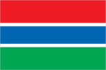
Flag description
three equal horizontal bands of red (top), blue with white edges, and green; red stands for the sun and the savannah, blue represents the Gambia River, and green symbolizes forests and agriculture; the white stripes denote unity and peace
Government type
republic
Independence
18 February 1965 (from the UK)
International law organization participation
accepts compulsory ICJ jurisdiction with reservations; accepts ICCt jurisdiction
International organization participation
ACP, AfDB, AU, ECOWAS, FAO, G-77, IBRD, ICAO, ICCt, ICRM, IDA, IDB, IFAD, IFC, IFRCS, ILO, IMF, IMO, Interpol, IOC, IOM, IPU, ISO (correspondent), ITSO, ITU, ITUC (NGOs), MIGA, MINUSMA, NAM, OIC, OPCW, UN, UNAMID, UNCTAD, UNESCO, UNIDO, UNMIL, UNOCI, UNWTO, UPU, WCO, WFTU (NGOs), WHO, WIPO, WMO, WTO
Judicial branch
- highest court(s)
- Supreme Court of The Gambia (consists of the chief justice and 6 other justices; court sessions held with 5 justices)
- judge selection and term of office
- justices appointed by the president after consultation with the Judicial Service Commission, a 6-member independent body of high-level judicial officials, a presidential appointee, and a National Assembly appointee; justices appointed for life or until mandatory retirement age
- subordinate courts
- Court of Appeal; High Court; Special Criminal Court; Khadis or Muslim courts; district tribunals; magistrates courts
Legal system
mixed legal system of English common law, Islamic law, and customary law
Legislative branch
- description
- unicameral National Assembly (53 seats; 48 members directly elected in single-seat constituencies by simple majority vote and 5 appointed by the president; members serve 5-year terms)
- election results
- percent of vote by party - APRC 51.8%, independent 38.8%, NRP 9.4%; seats by party - APRC 43, independent 4, NRP 1
- elections
- last held on 29 March 2012 (next to be held in 2017)
National anthem
- lyrics/music
- Virginia Julie HOWE/adapted by Jeremy Frederick HOWE
- name
- "For The Gambia, Our Homeland"
- note
- adopted 1965; the music is an adaptation of the traditional Mandinka song "Foday Kaba Dumbuya"
National holiday
Independence Day, 18 February (1965)
National symbol(s)
lion; national colors: red, blue, green, white
Political parties and leaders
- Alliance for Patriotic Reorientation and Construction or APRC [Yahya JAMMEH] (the ruling party)
- Gambia People's Democratic Party or GPDP [Henry GOMEZ]
- National Alliance for Democracy and Development or NADD [Halifa SALLAH]
- National Convention Party or NCP [Sheriff DIBBA]
- National Reconciliation Party or NRP [Hamat BAH]
- People's Democratic Organization for Independence and Socialism or PDOIS [Halifa SALLAH]
- People's Progressive Party or PPP [Omar JALLOW]
- United Democratic Party or UDP [Ousainou DARBOE]
Political pressure groups and leaders
- National Environment Agency or NEA
- West African Peace Building Network-Gambian Chapter or WANEB-GAMBIA
- Youth Employment Network Gambia or YENGambia
- other
- special needs group advocates; teachers and principals
Suffrage
18 years of age; universal
Economy
Agriculture - products
rice, millet, sorghum, peanuts, corn, sesame, cassava (manioc, tapioca), palm kernels; cattle, sheep, goats
Budget
- expenditures
- $242.6 million (2014 est.)
- revenues
- $177.6 million
Budget surplus (+) or deficit (-)
-7.1% of GDP (2014 est.)
Central bank discount rate
- 9% (31 December 2009)
- 11% (31 December 2008)
Commercial bank prime lending rate
- 33.5% (31 December 2014 est.)
- 28% (31 December 2013 est.)
Current account balance
- -$105 million (2014 est.)
- -$165.1 million (2013 est.)
Debt - external
- $583.9 million (31 December 2014 est.)
- $547.4 million (31 December 2013 est.)
Distribution of family income - Gini index
50.2 (1998)
Economy - overview
The Gambia has sparse natural resource deposits and a limited agricultural base. It relies heavily on remittances from workers overseas and tourist receipts. Remittance inflows to The Gambia amount to about 20% of the country’s GDP. The government has invested strongly in the agriculture sector because three-quarters of the population depends on the sector for its livelihood and agriculture provides for about one-fifth of GDP. The agricultural sector has untapped potential - less than half of arable land is cultivated. Small-scale manufacturing activity features the processing of peanuts, fish, and hides. The Gambia's natural beauty and proximity to Europe has made it one of the larger tourist destinations in West Africa, boosted by government and private sector investments in eco-tourism and upscale facilities. Tourism normally brings in about one-fifth of GDP, but suffered in 2014 from tourists’ fears of Ebolavirus in neighboring West African countries. The Gambia's re-export trade accounts for almost 80% of goods exports and China was its largest trade partner for both exports and imports in 2013. In 2012 the IMF renewed an extended credit facility of $28.3 million for three years. Unemployment and underemployment remain high. Economic progress depends on sustained bilateral and multilateral aid, on responsible government economic management, and on continued technical assistance from multilateral and bilateral donors. International donors and lenders continue to be concerned about the quality of fiscal management. The Gambia's debt interest payments are projected to consume about 31% of government revenue in 2015. Relations with international donors have been tarnished by the country’s human rights record on homosexuality and human trafficking, perceptions of graft, and a declaration by the president in 2014 that the country would stop using English as the national language.
Exchange rates
- dalasis (GMD) per US dollar -
- 39.98 (2014 est.)
- 36.57 (2013 est.)
- 32.08 (2012 est.)
- 29.4615 (2011 est.)
- 28.012 (2010 est.)
Exports
- $107.4 million (2014 est.)
- $104.6 million (2013 est.)
Exports - commodities
peanut products, fish, cotton lint, palm kernels
Exports - partners
China 34.4%, India 32.9%, UK 8.2%, France 4.4% (2014)
Fiscal year
calendar year
GDP - composition, by end use
- (2014 est.)
- exports of goods and services
- 28%
- government consumption
- 8.6%
- household consumption
- 92.4%
- imports of goods and services
- -53.1%
- investment in fixed capital
- 23.8%
- investment in inventories
- 0.3%
GDP - composition, by sector of origin
- agriculture
- 22.8%
- industry
- 11.8%
- services
- 65.5% (2014 est.)
GDP - per capita (PPP)
- $1,600 (2014 est.)
- $1,600 (2013 est.)
- $1,500 (2012 est.)
- note
- data are in 2014 US dollars
GDP - real growth rate
- -0.2% (2014 est.)
- 4.8% (2013 est.)
- 5.6% (2012 est.)
GDP (official exchange rate)
$825 million (2014 est.)
GDP (purchasing power parity)
- $3.082 billion (2014 est.)
- $3.089 billion (2013 est.)
- $2.948 billion (2012 est.)
- note
- data are in 2014 US dollars
Gross national saving
- 10.7% of GDP (2014 est.)
- 9.3% of GDP (2013 est.)
- 19.9% of GDP (2012 est.)
Household income or consumption by percentage share
- highest 10%
- 36.9% (2003)
- lowest 10%
- 2%
Imports
- $353.1 million (2014 est.)
- $355.8 million (2013 est.)
Imports - commodities
foodstuffs, manufactures, fuel, machinery and transport equipment
Imports - partners
China 31.3%, Brazil 8.6%, India 7.9%, Senegal 7.2% (2014)
Industrial production growth rate
0.3% (2014 est.)
Industries
peanuts, fish, hides, tourism, beverages, agricultural machinery assembly, woodworking, metalworking, clothing
Inflation rate (consumer prices)
- 6.3% (2014 est.)
- 5.7% (2013 est.)
Labor force
777,100 (2007 est.)
Labor force - by occupation
- agriculture
- 75%
- industry
- 19%
- services
- 6% (1996)
Market value of publicly traded shares
$NA
Population below poverty line
48.4% (2010 est.)
Reserves of foreign exchange and gold
- $227.9 million (31 December 2014 est.)
- $210.6 million (31 December 2013 est.)
Stock of broad money
- $534.7 million (31 December 2014 est.)
- $511.5 million (31 December 2013 est.)
Stock of domestic credit
- $416.3 million (31 December 2014 est.)
- $398.3 million (31 December 2013 est.)
Stock of narrow money
- $217.5 million (31 December 2014 est.)
- $215.5 million (31 December 2013 est.)
Taxes and other revenues
19.3% of GDP (2014 est.)
Unemployment rate
NA%
Energy
Carbon dioxide emissions from consumption of energy
472,200 Mt (2012 est.)
Crude oil - exports
0 bbl/day (2010 est.)
Crude oil - imports
0 bbl/day (2010 est.)
Crude oil - production
0 bbl/day (2013 est.)
Crude oil - proved reserves
0 bbl (1 January 2014 est.)
Electricity - consumption
213.9 million kWh (2011 est.)
Electricity - exports
0 kWh (2013 est.)
Electricity - from fossil fuels
100% of total installed capacity (2011 est.)
Electricity - from hydroelectric plants
0% of total installed capacity (2011 est.)
Electricity - from nuclear fuels
0% of total installed capacity (2011 est.)
Electricity - from other renewable sources
0% of total installed capacity (2011 est.)
Electricity - imports
0 kWh (2013 est.)
Electricity - installed generating capacity
62,000 kW (2011 est.)
Electricity - production
230 million kWh (2011 est.)
Natural gas - consumption
0 cu m (2012 est.)
Natural gas - exports
0 cu m (2012 est.)
Natural gas - imports
0 cu m (2012 est.)
Natural gas - production
0 cu m (2012 est.)
Natural gas - proved reserves
0 cu m (1 January 2014 est.)
Refined petroleum products - consumption
3,350 bbl/day (2013 est.)
Refined petroleum products - exports
42 bbl/day (2010 est.)
Refined petroleum products - imports
3,434 bbl/day (2010 est.)
Refined petroleum products - production
0 bbl/day (2010 est.)
Communications
Broadcast media
state-owned, single-channel TV service; state-owned radio station and 4 privately owned radio stations; transmissions of multiple international broadcasters are available, some via shortwave radio; cable and satellite TV subscription services are obtainable in some parts of the country (2007)
Internet country code
.gm
Internet users
- percent of population
- 14.2% (2014 est.)
- total
- 274,000
Radio broadcast stations
AM 3, FM 2, shortwave 0 (2001)
Telephone system
- domestic
- combined fixed-line and mobile-cellular teledensity, aided by multiple mobile-cellular providers, is roughly 80 per 100 persons
- general assessment
- adequate microwave radio relay and open-wire network; state-owned Gambia Telecommunications partially privatized in 2007
- international
- country code - 220; microwave radio relay links to Senegal and Guinea-Bissau; a landing station for the Africa Coast to Europe (ACE) undersea fiber-optic cable is scheduled for completion in 2011; satellite earth station - 1 Intelsat (Atlantic Ocean) (2011)
Telephones - fixed lines
- subscriptions per 100 inhabitants
- 3 (2014 est.)
- total subscriptions
- 55,800
Telephones - mobile cellular
- subscriptions per 100 inhabitants
- 119 (2014 est.)
- total
- 2.3 million
Television broadcast stations
1 (government-owned) (1997)
Transportation
Airports
1 (2013)
Airports - with paved runways
- over 3,047 m
- 1 (2013)
- total
- 1
Merchant marine
- by type
- passenger/cargo 3, petroleum tanker 1 (2010)
- total
- 4
Ports and terminals
- major seaport(s)
- Banjul
Roadways
- paved
- 711 km
- total
- 3,740 km
- unpaved
- 3,029 km (2011)
Waterways
390 km (on River Gambia; small oceangoing vessels can reach 190 km) (2010)
Military and Security
Manpower available for military service
- females age 16-49
- 438,641 (2010 est.)
- males age 16-49
- 423,306
Manpower fit for military service
- females age 16-49
- 347,017 (2010 est.)
- males age 16-49
- 315,176
Manpower reaching militarily significant age annually
- female
- 20,853 (2010 est.)
- male
- 20,508
Military branches
Office of the Chief of Defense Staff: Gambian National Army (GNA), Gambian Navy (GN), Republican National Guard (RNG) (2010)
Military service age and obligation
18 years of age for male and female voluntary military service; no conscription; service obligation 6 months (2012)
Transnational Issues
Disputes - international
attempts to stem refugees, cross-border raids, arms smuggling, and other illegal activities by separatists from southern Senegal's Casamance region, as well as from conflicts in other west African states
Refugees and internally displaced persons
- refugees (country of origin)
- 11,036 (Senegal) (2014)
Trafficking in persons
- current situation
- The Gambia is a source and destination country for women and children subjected to forced labor and sex trafficking; Gambian women, girls, and, to a lesser extent, boys are exploited for prostitution and domestic servitude; boys in some Koranic schools are forced into street vending or begging; women, girls, and boys from West African countries are trafficked to The Gambia for sexual exploitation, particularly catering to European tourists seeking sex with children; some Gambian trafficking victims are identified in neighboring West African countries
- tier rating
- Tier 3 – The Gambia does not fully comply with the minimum standards for the elimination of trafficking and is not making significant efforts to do so; the government did not report prosecuting or convicting any trafficking offenders in 2013, did not formally identify trafficking victims, and did not indicate whether victims received any government-supported services; a government program continued to provide resources and financial support to 12 Koranic schools on the condition that their students were not forced to beg (2014)