1991 Edition
CIA World Factbook 1991 (Project Gutenberg)
Geography
Climate
tropical; hot, rainy season (June to November); cooler, dry season (November to May)
Coastline
80 km
Comparative area
slightly more than twice the size of Delaware
Disputes
short section of boundary with Senegal is indefinite
Environment
deforestation
Land boundary
740 km with Senegal
Land use
arable land 16%; permanent crops 0%; meadows and pastures 9%; forest and woodland 20%; other 55%; includes irrigated 3%
Maritime claims
Contiguous zone: 18 nm; Continental shelf: not specific; Exclusive fishing zone: 200 nm; Territorial sea: 12 nm
Natural resources
fish
Note
almost an enclave of Senegal; smallest country on the continent of Africa
Terrain
flood plain of the Gambia River flanked by some low hills
Total area
11,300 km2; land area: 10,000 km2
People and Society
Birth rate
48 births/1,000 population (1991)
Death rate
17 deaths/1,000 population (1991)
Ethnic divisions
African 99% (Mandinka 42%, Fula 18%, Wolof 16%, Jola 10%, Serahuli 9%, other 4%); non-Gambian 1%
Infant mortality rate
138 deaths/1,000 live births (1991)
Labor force
400,000 (1986 est.); agriculture 75.0%, industry, commerce, and services 18.9%, government 6.1%; 55% population of working age (1983)
Language
English (official); Mandinka, Wolof, Fula, other indigenous vernaculars
Life expectancy at birth
47 years male, 51 years female (1991)
Literacy
27% (male 39%, female 16%) age 15 and over can read and write (1990 est.)
Nationality
noun--Gambian(s); adjective--Gambian
Net migration rate
0 migrants/1,000 population (1991)
Organized labor
25-30% of wage labor force
Population
874,553 (July 1991), growth rate 3.1% (1991)
Religion
Muslim 90%, Christian 9%, indigenous beliefs 1%
Total fertility rate
6.5 children born/woman (1991)
Government
Administrative divisions
5 divisions and 1 city*; Banjul*, Lower River, MacCarthy Island, North Bank, Upper River, Western
Capital
Banjul
Communists
no Communist party
Constitution
24 April 1970
Diplomatic representation
Ambassador Ousman A. SALLAH; Chancery at Suite 720, 1030 15th Street NW, Washington DC 20005; telephone (202) 842-1356 or 842-1359; US--Ambassador Arlene RENDER; Embassy at Pipeline Road (Kairaba Avenue), Fajara, Banjul (mailing address is P. M. B. No. 19, Banjul); telephone Serrekunda [220] 92856 or 92858, 91970, 91971
Elections
President--last held on 11 March 1987 (next to be held March 1992); results--Sir Dawda JAWARA (PPP) 61.1%, Sherif Mustapha DIBBA (NCP) 25.2%, Assan Musa CAMARA (GPP) 13.7%; House of Representatives--last held on 11 March 1987 (next to be held by March 1992); results--PPP 56.6%, NCP 27.6%, GPP 14.7%, PDOIS 1%; seats--(43 total, 36 elected) PPP 31, NCP 5
Executive branch
president, vice president, Cabinet
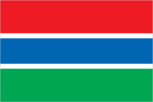
Flag
three equal horizontal bands of red (top), blue with white edges, and green
Independence
18 February 1965 (from UK); The Gambia and Senegal signed an agreement on 12 December 1981 (effective 1 February 1982) that called for the creation of a loose confederation to be known as Senegambia, but the agreement was dissolved on 30 September 1989
Judicial branch
Supreme Court
Leaders
Chief of State and Head of Government--President Alhaji Sir Dawda Kairaba JAWARA (since 24 April 1970); Vice President Bakary Bunja DARBO (since 12 May 1982)
Legal system
based on a composite of English common law, Koranic law, and customary law; accepts compulsory ICJ jurisdiction, with reservations
Legislative branch
unicameral House of Representatives
Long-form name
Republic of The Gambia
Member of
ACP, AfDB, C, CCC, ECA, ECOWAS, FAO, G-77, GATT, IBRD, ICAO, ICFTU, IDA, IDB, IFAD, IFC, IMF, IMO, INTERPOL, IOC, ITU, LORCS, NAM, OAU, OIC, UN, UNCTAD, UNESCO, UNIDO, UPU, WCL, WFTU, WHO, WIPO, WMO, WTO
National holiday
Independence Day, 18 February (1965)
Political parties and leaders
People's Progressive Party (PPP), Dawda K. JAWARA, secretary general; National Convention Party (NCP), Sheriff DIBBA; Gambian People's Party (GPP), Assan Musa CAMARA; United Party (UP); People's Democratic Organization of Independence and Socialism (PDOIS)
Suffrage
universal at age 21
Type
republic
Economy
Agriculture
accounts for 30% of GDP and employs about 75% of the population; imports one-third of food requirements; major export crop is peanuts; the principal crops--millet, sorghum, rice, corn, cassava, palm kernels; livestock--cattle, sheep, and goats; forestry and fishing resources not fully exploited
Budget
revenues $79 million; expenditures $84 million, including capital expenditures of $21 million (FY90)
Currency
dalasi (plural--dalasi); 1 dalasi (D) = 100 bututs
Economic aid
US commitments, including Ex-Im (FY70-89), $93 million; Western (non-US) countries, ODA and OOF bilateral commitments (1970-88), $492 million; Communist countries (1970-88), $39 million
Electricity
29,000 kW capacity; 64 million kWh produced, 80 kWh per capita (1989)
Exchange rates
dalasi (D) per US$1--7.610 (January 1991), 7.883 (1990), 7.5846 (1989), 6.7086 (1988), 7.0744 (1987), 6.9380 (1986), 3.8939 (1985)
Exports
$116 million (f.o.b., FY90); commodities--peanuts and peanut products, fish, cotton lint, palm kernels; partners--Japan 60%, Europe 29%, Africa 5%, US 1% other 5% (1989)
External debt
$336 million (December 1990 est.)
Fiscal year
1 July-30 June
GDP
$195 million, per capita $230; real growth rate 6.0% (FY90 est.)
Imports
$147 million (f.o.b., FY90); commodities--foodstuffs, manufactures, raw materials, fuel, machinery and transport equipment; partners--Europe 57%, Asia 25%, USSR/EE 9%, US 6%, other 3% (1989)
Industrial production
growth rate 6.7%; accounts for 5.8% of GDP (FY90)
Industries
peanut processing, tourism, beverages, agricultural machinery assembly, woodworking, metalworking, clothing
Inflation rate (consumer prices)
6.0% (FY91)
Overview
The Gambia has no important mineral or other natural resources and has a limited agricultural base. It is one of the world's poorest countries with a per capita income of about $230. About 75% of the population is engaged in crop production and livestock raising, which contributes 30% to GDP. Small-scale manufacturing activity--processing peanuts, fish, and hides--accounts for less than 10% of GDP. Tourism is a growing industry. The Gambia imports one-third of its food, all fuel, and most manufactured goods. Exports are concentrated on peanut products (about 75% of total value).
Unemployment rate
NA%
Communications
Airports
1 with permanent-surface runway 2,440-3,659 m
Civil air
2 major transport aircraft
Highways
3,083 km total; 431 km paved, 501 km gravel/laterite, and 2,151 km unimproved earth
Inland waterways
400 km
Ports
Banjul
Telecommunications
adequate network of radio relay and wire; 3,500 telephones; stations--3 AM, 2 FM, 1 TV; 1 Atlantic Ocean INTELSAT earth station
Military and Security
Branches
Army, Navy, paramilitary Gendarmerie, National Police
Defense expenditures
$NA, 0.7% of GDP (1988) _%_
Manpower availability
males 15-49, 188,393; 95,133 fit for military service