2011 Edition
CIA World Factbook 2011 Archive (HTML)
Introduction
Background
Egypt attempted to colonize the region of southern Sudan by establishing the province of Equatoria in the 1870s. Islamic Mahdist revolutionaries overran the region in 1885, but in 1898 a British force was able to overthrow the Mahdist regime. An Anglo-Egyptian Sudan was established the following year with Equatoria being the southernmost of its eight provinces. The isolated region was largely left to itself over the following decades, but Christian missionaries converted much of the population and facilitated the spread of English. When Sudan gained its independence in 1956, it was with the understanding that the southerners would be able to participate fully in the political system. When the Arab Khartoum government reneged on its promises, a mutiny began that led to two prolonged periods of conflict (1955-1972 and 1983-2005) in which perhaps 2.5 million people died - mostly civilians - due to starvation and drought. Ongoing peace talks finally resulted in a Comprehensive Peace Agreement, signed in January 2005. As part of this agreement the south was granted a six-year period of autonomy to be followed by a referendum on final status. The result of this referendum, held in January 2011, was a vote of 98% in favor of secession. Independence was attained on 9 July 2011.
Geography
Area
- 644,329 sq km
- total
- 644,329 sq km
Area - comparative
slightly smaller than Texas
Climate
hot with seasonal rainfall influenced by the annual shift of the Inter-Tropical Convergence Zone; rainfall is heaviest in the upland areas of the south and diminishes to the north
Coastline
0 km (landlocked)
Elevation extremes
- NA Kinyeti 3,187 m
- highest point
- Kinyeti 3,187 m
- Lowest point
- NA
Geographic coordinates
8 00 N, 30 00 E
Geography - note
The Sudd is a vast swamp in South Sudan, formed by the White Nile, comprising more than 15% of the total area; it is one of the world's largest wetlands
Land boundaries
- 5,413 km Central African Republic 989 km, Democratic Republic of the Congo 639 km, Ethiopia 934 km, Kenya 232 km, Sudan 2,184 km, Uganda 435 km South Sudan-Sudan boundary represents 1 January 1956 alignment; final alignment pending negotiations and demarcation; final sovereignty status of Abyei Area pending negotiations between South Sudan and Sudan
- border countries
- Central African Republic 989 km, Democratic Republic of the Congo 639 km, Ethiopia 934 km, Kenya 232 km, Sudan 2,184 km, Uganda 435 km
- total
- 5,413 km
Location
Sahel region of northeastern Africa; south of Sudan, north of Uganda and Kenya, west of Ethiopia
Map references
Africa
Maritime claims
none (landlocked)
Natural resources
hydropower, fertile agricultural land, gold, diamonds, petroleum, hardwoods, limestone, iron ore, copper, chromium ore, zinc, tungsten, mica, silver
Terrain
the terrain gradually rises from plains in the north and center to southern highlands along the border with Uganda and Kenya; the White Nile, flowing north out of the uplands of Central Africa, is the major geographic feature of the country supporting agriculture and extensive wild animal populations; The Sudd (a name derived from floating vegetation that hinders navigation) is a large swampy area of more than 100,000 sq km fed by the waters of the White Nile that dominates the center of the country
People and Society
Age structure
- 44.4% (male 1,945,033/female 1,722,860) 53% (male 2,216,427/female 2,157,893) 2.6% (male 125,840/female 92,437) (2008)
- 0-14 years
- 44.4% (male 1,945,033/female 1,722,860)
- 15-64 years
- 53% (male 2,216,427/female 2,157,893)
- 65 years and over
- 2.6% (male 125,840/female 92,437) (2008)
Drinking water source
- urban: 67% of population rural: 53% of population total: 55% of population
- rural
- 53% of population
- total
- 55% of population
- urban
- 67% of population
Ethnic groups
Dinka, Kakwa, Bari, Azande, Shilluk, Kuku, Murle, Mandari, Didinga, Ndogo, Bviri, Lndi, Anuak, Bongo, Lango, Dungotona, Acholi
HIV/AIDS - adult prevalence rate
3.1% (2009 est.)
Infant mortality rate
- 102 deaths/1,000 live births (2006)
- total
- 102 deaths/1,000 live births (2006)
Languages
English (official), Arabic (includes Juba and Sudanese variants) (official), regional languages include Dinka, Nuer, Bari, Zande, Shilluk
Literacy
- age 15 and over can read and write 27% 40% 16%
- definition
- age 15 and over can read and write
- female
- 16%
- male
- 40%
- total population
- 27%
Major cities - population
JUBA (capital) 250,000 (2008 est.)
Major infectious diseases
- very high bacterial and protozoal diarrhea, hepatitis A and E, and typhoid fever malaria, dengue fever, African trypanosomiasis (sleeping sickness) schistosomiasis meningococcal meningitis rabies
- animal contact disease
- rabies
- degree of risk
- very high
- food or waterborne disease
- bacterial and protozoal diarrhea, hepatitis A and E, and typhoid fever
- respiratory disease
- meningococcal meningitis
- vectorborne disease
- malaria, dengue fever, African trypanosomiasis (sleeping sickness)
- water contact disease
- schistosomiasis
Nationality
- South Sudanese (singular and plural) South Sudanese
- adjective
- South Sudanese
- noun
- South Sudanese (singular and plural)
Population
8,260,490 (according to disputed 2008 census; actual number may be as high as 9.28 million) (2008)
Religions
animist, Christian
Urbanization
- 22% (2009 est.)
- urban population
- 22% (2009 est.)
Government
Administrative divisions
10 states; Central Equatoria, Eastern Equatoria, Jonglei, Lakes, Northern Bahr el Ghazal, Unity, Upper Nile, Warrap, Western Bahr el Ghazal, Western Equatoria
Capital
- Juba 04 51 N 31 37 E UTC+3 (8 hours ahead of Washington, DC during Standard Time)
- geographic coordinates
- 04 51 N 31 37 E
- name
- Juba
- time difference
- UTC+3 (8 hours ahead of Washington, DC during Standard Time)
Constitution
Transitional Constitution of the Republic of South Sudan 2011, effective 9 July 2011
Country name
- Republic of South Sudan South Sudan
- conventional long form
- Republic of South Sudan
- conventional short form
- South Sudan
Diplomatic representation from the US
- Ambassador (vacant), Charge d' Affaires R. Barrie WALKLEY Juba
- chief of mission
- Ambassador (vacant), Charge d' Affaires R. Barrie WALKLEY
- embassy
- Juba
Diplomatic representation in the US
- Ambassador (vacant), head of mission Ezekiel Lol GATKOUTH 1233 20th St. NW, Suite 602, Washington, DC 20036 [1] (202) 293-7943 [1] (202) 293-7941
- chancery
- 1233 20th St. NW, Suite 602, Washington, DC 20036
- chief of mission
- Ambassador (vacant), head of mission Ezekiel Lol GATKOUTH
- FAX
- [1] (202) 293-7941
- telephone
- [1] (202) 293-7943
Executive branch
- President Salva KIIR Mayardit (since 9 July 2011); Vice President Riek MACHAR (since 10 July 2011); note - the president is both chief of state and head of government President Salva KIIR Mayardit (since 9 July 2011); Vice President Riek MACHAR (since 10 July 2011) National Council of Ministers; appointed by the president and approved by a resolution from the Legislative Assembly president elected by popular vote for a four year term; election last held on 11-15 April 2010 (next to be held in 2015) Salva KIIR Mayardit elected president; percent of vote - Salva KIIR Mayardit 93%, Lam AKOL 7%
- cabinet
- National Council of Ministers; appointed by the president and approved by a resolution from the Legislative Assembly
- chief of state
- President Salva KIIR Mayardit (since 9 July 2011); Vice President Riek MACHAR (since 10 July 2011); note - the president is both chief of state and head of government
- election results
- Salva KIIR Mayardit elected president; percent of vote - Salva KIIR Mayardit 93%, Lam AKOL 7%
- elections
- president elected by popular vote for a four year term; election last held on 11-15 April 2010 (next to be held in 2015)
- head of government
- President Salva KIIR Mayardit (since 9 July 2011); Vice President Riek MACHAR (since 10 July 2011)
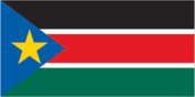
Flag description
three equal horizontal bands of black (top), red, and green; the red band is edged in white; a blue isosceles triangle based on the hoist side contains a gold, five-pointed star; black represents the people of South Sudan, red the blood shed in the struggle for freedom, green the verdant land, and blue the waters of the Nile; the gold star represents the unity of the states making up South Sudan resembles the flag of Kenya; one of only two national flags to display six colors as part of its primary design, the other is South Africa's
Government type
republic
Independence
9 July 2011 (from Sudan)
International organization participation
AU, IFRCS, Interpol, ITU, UN, UNCTAD, UNESCO, UPU
Judicial branch
Supreme Court, Courts of Appeal, High Courts, County Courts
Legislative branch
- bicameral National Legislature consists of the National Legislative Assembly (332 seats) and the Council of States (50 seats); members serve four-year terms National Legislative Assembly - last held 11-15 April 2010 (next to be held in 2015); Council of States - established and members appointed 1 August 2011 National Legislative Assembly - percent of vote by party - NA; seats by party - SPLM 251, SPLM-DC 6, NCP 3, independent 6, unknown 66; Council of States - seats by party - SPLM 20, unknown 30 a presidential decree of 1 August 2011 reconstituted the National Legislative Assembly, as permitted under Article 94 of the Transitional Constitution, to include the 170 members elected 11-15 April 2010, 96 former members of the National Assembly of the Republic of Sudan, and 66 newly appointed members for a total of 332; a presidential decree also established a Council of States, initially with 50 members - the 20 former members of the Council of States of the Republic of Sudan plus an additional 30 appointed representatives
- election results
- National Legislative Assembly - percent of vote by party - NA; seats by party - SPLM 251, SPLM-DC 6, NCP 3, independent 6, unknown 66; Council of States - seats by party - SPLM 20, unknown 30
- elections
- National Legislative Assembly - last held 11-15 April 2010 (next to be held in 2015); Council of States - established and members appointed 1 August 2011
National anthem
- South Sudan Oyee! (Hooray!) collective of 49 poets/Juba University students and teachers adopted 2011; the anthem was selected in a national contest
- lyrics/music
- collective of 49 poets/Juba University students and teachers
- name
- South Sudan Oyee! (Hooray!)
National holiday
Independence Day, (9 July 2011)
National symbol(s)
African fish eagle
Political parties and leaders
Sudan People's Liberation Movement or SPLM; National Congress Party or NCP; Sudan People's Liberation Movement for Democratic Change or SPLM-DC
Economy
Agriculture - products
sorghum, maize, rice, millet, wheat, gum arabic, sugarcane, mangoes, papayas, bananas, sweet potatoes sunflower, cotton, sesame, cassava, beans, peanuts; cattle, sheep
Economy - overview
Industry and infrastructure in landlocked South Sudan are severely underdeveloped and poverty is widespread, following several decades of civil war with the north. Subsistence agriculture provides a living for the vast majority of the population. Property rights are tentative and price signals are missing because markets are not well organized. South Sudan has little infrastructure - just 60 km of paved roads. Electricity is produced mostly by costly diesel generators and running water is scarce. The government spends large sums of money to maintain a large army; delays in paying salaries have resulted in riots by unruly soldiers. Ethnic conflicts have resulted in a large number of civilian deaths and displacement. South Sudan depends largely on imports of goods, services, and capital from the north. Despite these disadvantages, South Sudan does have abundant natural resources. South Sudan produces nearly three-fourths of the former Sudan's total oil output of nearly a half million barrels per day. The government of South Sudan derives nearly 98% of its budget revenues from oil. Oil is exported through two pipelines that run to refineries and shipping facilities at Port Sudan on the Red Sea, and the 2005 oil sharing agreement with Khartoum called for a 50-50 sharing of oil revenues between the two entities. That deal expired on 9 July, however, when South Sudan became an independent country. The economy of South Sudan undoubtedly will remain linked to Sudan for some time, given the long lead time and great expense required to build another pipeline. South Sudan also holds one of the richest agricultural areas in Africa in the White Nile valley, which has very fertile soils and more-than-adequate water supplies. Currently the region supports 10-20 million head of cattle. South Sudan also contains large wildlife herds, which could be exploited in the future to attract eco-tourists. And the White Nile has sufficient flow to generate large quantities of hydroelectricity. South Sudan does not have large external debt or structural trade deficits. South Sudan has received more than $4 billion in foreign aid since 2005, largely from the UK, US, Norway, and Netherlands, but Khartoum has imposed blockades on goods and capital going to South Sudan. The World Bank plans to support investment in infrastructure, agriculture, and power generation. The Government of South Sudan has set a target for economic growth of 6% for the remainder of 2011, and expects 7.2% growth in 2012. Inflation stood at 8.6% in April 2011, with high fuel prices pushing up food prices. After independence, South Sudan's central bank plans to issue a new currency, the South Sudanese Pound, allowing a short grace period for turning in the old currency. Long term problems include alleviating poverty, maintaining macroeconomic stability, improving tax collection and financial management, focusing resources on speeding growth, and improving the business environment.
Communications
Broadcast media
TV is controlled by the government; several private FM stations are operational in South Sudan; some foreign radio broadcasts are available
Internet country code
.sd; note - IANA has not yet designated a separate country code for South Sudan
Telephone system
- country code - 211
- international
- country code - 211
Transportation
Airports
: 24 country comparison to the world: 133
Airports - with paved runways
- 1,524 to 2,437 m
- 2
- total
- 2
Airports - with unpaved runways
- 1,524 to 2,437 m
- 5
- 914 to 1,523 m
- 16
- total
- 22
- under 914 m
- 1
Railways
est. 236 km; note - rail system reported to be in disrepair (2010)
Roadways
est. 7,000 km; note - very little of the road network is paved and much of it is in disrepair (2010)
Waterways
see entry for Sudan
Military and Security
Military branches
South Sudan Armed Forces
Military service age and obligation
the Government of South Sudan announced in August 2010 that anyone younger than 18 years of age would be mustered out of the army, but 900 children were estimated to still be active at the end of that year; in April 2011, a conscription program was being implemented to thwart recruitment of military-aged males into other armed groups (2011)
Transnational Issues
Disputes - international
South Sudan-Sudan boundary represents 1 January 1956 alignment, final alignment pending negotiations and demarcation; final sovereignty status of Abyei Area pending negotiations between South Sudan and Sudan; periodic violent skirmishes with South Sudanese residents over water and grazing rights persist among related pastoral populations along the border with the Central African Republic; the boundary that separates Kenya and South Sudan's sovereignty is unclear in the "Ilemi Triangle," which Kenya has administered since colonial times
Refugees and internally displaced persons
- 21,000 (mostly from Democratic Republic of the Congo and Ethiopia) 80,000 (2010)
- IDPs
- 80,000 (2010)
- refugees (country of origin)
- 21,000 (mostly from Democratic Republic of the Congo and Ethiopia)