2022 Edition
CIA World Factbook 2022 (factbook.json @ 61dadec0c9c9)
Introduction
Background
Settlers from Papua arrived on Solomon Islands around 30,000 years ago. About 6,000 years ago, Austronesian settlers came to Solomon Islands and the two groups mixed extensively. Despite significant inter-island trade, no attempts were made to unite the islands into a single political entity. In 1568, Spanish explorer Alvaro de MENDANA became the first European to spot the islands. After a failed Spanish attempt at creating a permanent European settlement on the islands in the late 1500s, Solomon Islands remained free of European contact until 1767 when British explorer Philip CARTERET sailed by the islands. The islands were regularly visited by European explorers and American and British whaling ships into the 1800s, followed by missionaries in the 1850s.Germany declared a protectorate over the northern Solomon Islands in 1885, and the UK established a protectorate over the southern islands in 1893. In 1899, Germany transferred its Solomon Islands to the UK in exchange for the UK relinquishing all claims in Samoa. The UK tried to encourage plantation farming, but few Europeans were willing to go to Solomon Islands and the UK left most services - such as education and medical services - to missionaries. In 1942, Japan invaded Solomon Islands and significant battles against Allied forces during the Guadalcanal Campaign proved a turning point in the Pacific war. World War II destroyed large parts of Solomon Islands and a nationalism movement emerged near the end of the war. By 1960, the British relented to allow for some local autonomy. The islands were granted self-government in 1976 and independence two years later under Prime Minister Sir Peter KENILOREA.In 1999, longstanding ethnic tensions between ethnic Guale in Honiara and ethnic Malaitans in Honiara’s suburbs erupted in civil war, leading thousands of Malaitans to take refuge in Honiara and Guale to flee the city. In 2000, newly-elected Prime Minister Manasseh SOGAVARE focused on peace agreements and distributing resources equally among groups, but his actions bankrupted the government in 2001 and led to SOGAVARE’s ouster. In 2003, Solomon Islands requested international assistance to reestablish law and order. The Australian-led Regional Assistance Mission to the Solomon Islands, which ended in 2017, was generally effective in improving the security situation. In 2006, riots broke out in Honiara and the city’s Chinatown burned over allegations that the prime minister took money from China. SOGAVARE was reelected prime minister for a fourth time following elections in 2019 and that same year announced Solomon Islands would switch diplomatic recognition from Taiwan to China. In late November 2021, protestors, mostly from the island of Malaita, calling for SOGAVARE’s removal and more development in Malaita, sparked rioting in Honiara.
Geography
Area
- land
- 27,986 sq km
- total
- 28,896 sq km
- water
- 910 sq km
Area - comparative
slightly smaller than Maryland
Climate
tropical monsoon; few temperature and weather extremes
Coastline
5,313 km
Elevation
- highest point
- Mount Popomanaseu 2,335 m
- lowest point
- Pacific Ocean 0 m
Geographic coordinates
8 00 S, 159 00 E
Geography - note
strategic location on sea routes between the South Pacific Ocean, the Solomon Sea, and the Coral Sea; Rennell Island, the southernmost in the Solomon Islands chain, is one of the world’s largest raised coral atolls; the island’s Lake Tegano, formerly a lagoon on the atoll, is the largest lake in the insular Pacific (15,500 hectares)
Irrigated land
0 sq km (2022)
Land boundaries
- total
- 0 km
Land use
- agricultural land
- 3.9% (2018 est.)
- agricultural land: arable land
- arable land: 0.7% (2018 est.)
- agricultural land: permanent crops
- permanent crops: 2.9% (2018 est.)
- agricultural land: permanent pasture
- permanent pasture: 0.3% (2018 est.)
- forest
- 78.9% (2018 est.)
- other
- 17.2% (2018 est.)
Location
Oceania, group of islands in the South Pacific Ocean, east of Papua New Guinea
Map references
Oceania
Maritime claims
- continental shelf
- 200 nm
- exclusive economic zone
- 200 nm
- note
- measured from claimed archipelagic baselines
- territorial sea
- 12 nm
Natural hazards
tropical cyclones, but rarely destructive; geologically active region with frequent earthquakes, tremors, and volcanic activity; tsunamisvolcanism: Tinakula (851 m) has frequent eruption activity, while an eruption of Savo (485 m) could affect the capital Honiara on nearby Guadalcanal
Natural resources
fish, forests, gold, bauxite, phosphates, lead, zinc, nickel
Population distribution
most of the population lives along the coastal regions; about one in five live in urban areas, and of these some two-thirds reside in Honiara, the largest town and chief port
Terrain
mostly rugged mountains with some low coral atolls
People and Society
Age structure
- 0-14 years
- 32.99% (male 116,397/female 109,604)
- 15-24 years
- 19.82% (male 69,914/female 65,874)
- 25-54 years
- 37.64% (male 131,201/female 126,681)
- 55-64 years
- 5.04% (male 17,844/female 16,704)
- 65 years and over
- 4.51% (male 14,461/female 16,417) (2020 est.)
Alcohol consumption per capita
- beer
- 1.1 liters of pure alcohol (2019 est.)
- other alcohols
- 0 liters of pure alcohol (2019 est.)
- spirits
- 0.02 liters of pure alcohol (2019 est.)
- total
- 1.19 liters of pure alcohol (2019 est.)
- wine
- 0.06 liters of pure alcohol (2019 est.)
Birth rate
22.71 births/1,000 population (2022 est.)
Children under the age of 5 years underweight
16.2% (2015)
Contraceptive prevalence rate
29.3% (2015)
Current health expenditure
4.8% of GDP (2019)
Death rate
3.96 deaths/1,000 population (2022 est.)
Dependency ratios
- elderly dependency ratio
- 6
- potential support ratio
- 16.5 (2021 est.)
- total dependency ratio
- 74.8
- youth dependency ratio
- 68.8
Drinking water source
- improved: rural
- rural: 65.9% of population
- improved: total
- total: 73.1% of population
- improved: urban
- urban: 95% of population
- unimproved: rural
- rural: 34.1% of population
- unimproved: total
- total: 26.9% of population (2020 est.)
- unimproved: urban
- urban: 5% of population
Education expenditures
12.8% of GDP (2020 est.)
Ethnic groups
Melanesian 95.3%, Polynesian 3.1%, Micronesian 1.2%, other 0.3% (2009 est.)
HIV/AIDS - adult prevalence rate
NA
Hospital bed density
1.4 beds/1,000 population (2012)
Infant mortality rate
- female
- 15.96 deaths/1,000 live births (2022 est.)
- male
- 23.89 deaths/1,000 live births
- total
- 20.02 deaths/1,000 live births
Languages
Melanesian pidgin (in much of the country is lingua franca), English (official but spoken by only 1%-2% of the population), 120 indigenous languages
Life expectancy at birth
- female
- 79.49 years (2022 est.)
- male
- 74.05 years
- total population
- 76.7 years
Literacy
- female
- NA
- male
- NA
- total population
- NA
Major infectious diseases
- degree of risk
- high (2020)
- food or waterborne diseases
- bacterial diarrhea
- vectorborne diseases
- malaria
Major urban areas - population
82,000 HONIARA (capital) (2018)
Maternal mortality ratio
104 deaths/100,000 live births (2017 est.)
Median age
- female
- 23.7 years (2020 est.)
- male
- 23.2 years
- total
- 23.5 years
Mother's mean age at first birth
- 22.6 years (2015 est.)
- note
- note: data represents median age at first birth among women 25-29
Nationality
- adjective
- Solomon Islander
- noun
- Solomon Islander(s)
Net migration rate
-1.55 migrant(s)/1,000 population (2022 est.)
Obesity - adult prevalence rate
22.5% (2016)
Physicians density
0.19 physicians/1,000 population (2016)
Population
702,694 (2022 est.)
Population distribution
most of the population lives along the coastal regions; about one in five live in urban areas, and of these some two-thirds reside in Honiara, the largest town and chief port
Population growth rate
1.72% (2022 est.)
Religions
Protestant 73.4% (Church of Melanesia 31.9%, South Sea Evangelical 17.1%, Seventh Day Adventist 11.7%, United Church 10.1%, Christian Fellowship Church 2.5%), Roman Catholic 19.6%, other Christian 2.9%, other 4%, unspecified 0.1% (2009 est.)
Sanitation facility access
- improved: rural
- rural: 22.6% of population
- improved: total
- total: 40.6% of population
- improved: urban
- urban: 95.6% of population
- unimproved: rural
- rural: 77.4% of population
- unimproved: total
- total: 59.4% of population (2020 est.)
- unimproved: urban
- urban: 4.4% of population
Sex ratio
- 0-14 years
- 1.06 male(s)/female
- 15-24 years
- 1.06 male(s)/female
- 25-54 years
- 1.04 male(s)/female
- 55-64 years
- 1.08 male(s)/female
- 65 years and over
- 0.74 male(s)/female
- at birth
- 1.05 male(s)/female
- total population
- 1.04 male(s)/female (2022 est.)
Tobacco use
- female
- 19.2% (2020 est.)
- male
- 53.8% (2020 est.)
- total
- 36.5% (2020 est.)
Total fertility rate
2.87 children born/woman (2022 est.)
Urbanization
- rate of urbanization
- 3.57% annual rate of change (2020-25 est.)
- urban population
- 26% of total population (2023)
Youth unemployment rate (ages 15-24)
- female
- 1.6% (2013)
- male
- 1%
- total
- 1.3%
Government
Administrative divisions
9 provinces and 1 city*; Central, Choiseul, Guadalcanal, Honiara*, Isabel, Makira and Ulawa, Malaita, Rennell and Bellona, Temotu, Western
Capital
- etymology
- the name derives from "nagho ni ara," which in one of the Guadalcanal languages roughly translates as "facing the eastern wind"
- geographic coordinates
- 9 26 S, 159 57 E
- name
- Honiara
- time difference
- UTC+11 (16 hours ahead of Washington, DC, during Standard Time)
Citizenship
- citizenship by birth
- no
- citizenship by descent only
- at least one parent must be a citizen of the Solomon Islands
- dual citizenship recognized
- no
- residency requirement for naturalization
- 7 years
Constitution
- amendments
- proposed by the National Parliament; passage of constitutional sections, including those on fundamental rights and freedoms, the legal system, Parliament, alteration of the constitution and the ombudsman, requires three-fourths majority vote by Parliament and assent of the governor general; passage of other amendments requires two-thirds majority vote and assent of the governor general; amended several times, last in 2018; note - a new constitution was drafted in mid-2009 and the latest version drafted in 2013
- history
- adopted 31 May 1978, effective 7 July 1978; note - in late 2017, provincial leaders agreed to adopt a new federal constitution, with passage expected in 2018, but it has been postponed indefinitely
Country name
- conventional long form
- none
- conventional short form
- Solomon Islands
- etymology
- Spanish explorer Alvaro de MENDANA named the isles in 1568 after the wealthy biblical King SOLOMON in the mistaken belief that the islands contained great riches
- former
- British Solomon Islands
- local long form
- none
- local short form
- Solomon Islands
Diplomatic representation from the US
- embassy
- the US does not have an embassy in the Solomon Islands; the US Ambassador to Papua New Guinea is accredited to the Solomon Islands
Diplomatic representation in the US
- chancery
- 685 Third Avenue, 11th Floor, Suite 1102, New York, NY 10017
- chief of mission
- Ambassador Jane Mugafalu Kabui WAETARA (since 16 September 2022)
- email address and website
- simun@solomons.com
- FAX
- [1] (212) 661-8925
- telephone
- [1] (212) 599-6192; [1] (212) 599-6193
Executive branch
- cabinet
- Cabinet appointed by the governor general on the advice of the prime minister
- chief of state
- King CHARLES III (since 8 September 2022); represented by Governor General David VUNAGI (since 8 July 2019)
- election results
- Manasseh SOGAVARE elected prime minister on 24 April 2019
- elections/appointments
- the monarchy is hereditary; governor general appointed by the monarch on the advice of the National Parliament for up to 5 years (eligible for a second term); following legislative elections, the leader of the majority party or majority coalition usually elected prime minister by the National Parliament; deputy prime minister appointed by the governor general on the advice of the prime minister from among members of the National Parliament
- head of government
- Prime Minister Manasseh SOGAVARE (since 24 April 2019)
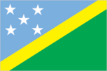
Flag description
divided diagonally by a thin yellow stripe from the lower hoist-side corner; the upper triangle (hoist side) is blue with five white five-pointed stars arranged in an X pattern; the lower triangle is green; blue represents the ocean, green the land, and yellow sunshine; the five stars stand for the five main island groups of the Solomon Islands
Government type
parliamentary democracy under a constitutional monarchy; a Commonwealth realm
Independence
7 July 1978 (from the UK)
International law organization participation
has not submitted an ICJ jurisdiction declaration; non-party state to the ICCt
International organization participation
ACP, ADB, AOSIS, C, EITI (candidate country), ESCAP, FAO, G-77, IBRD, ICAO, ICRM, IDA, IFAD, IFC, IFRCS, ILO, IMF, IMO, IOC, ITU, MIGA, OPCW, PIF, Sparteca, SPC, UN, UNCTAD, UNESCO, UPU, WFTU, WHO, WMO, WTO
Judicial branch
- highest court(s)
- Court of Appeal (consists of the court president and ex officio members including the High Court chief justice and its puisne judges); High Court (consists of the chief justice and puisne judges, as prescribed by the National Parliament)
- judge selection and term of office
- Court of Appeal and High Court president, chief justices, and puisne judges appointed by the governor general upon recommendation of the Judicial and Legal Service Commission, chaired by the chief justice and includes 5 members, mostly judicial officials and legal professionals; all judges serve until retirement at age 60
- subordinate courts
- Magistrates' Courts; Customary Land Appeal Court; local courts
Legal system
mixed legal system of English common law and customary law
Legislative branch
- description
- unicameral National Parliament (50 seats; members directly elected in single-seat constituencies by simple majority vote to serve 4-year terms)
- election results
- percent of vote by party - UDP 10.7%, DAP 7.8%, PAP 4.4%, independent 56.3%, other 20.8%; seats by party - DAP 7, UDP 5, PAP 3, KPSI 1, SIPFP 1, SIPRA 1, independent 32; composition - men 46, women 4, percent of women 8%
- elections
- last held on 3 April 2019 (next to be held in April 2023)
National anthem
- lyrics/music
- Panapasa BALEKANA and Matila BALEKANA/Panapasa BALEKANA
- name
- "God Save Our Solomon Islands"
- note
- note: adopted 1978
National heritage
- selected World Heritage Site locales
- East Rennell
- total World Heritage Sites
- 1 (natural)
National holiday
Independence Day, 7 July (1978)
National symbol(s)
national colors: blue, yellow, green, white
Political parties and leaders
- Democratic Alliance Party or DAP [Steve ABANA]Kadere Party of Solomon Islands or KPSI [Peter BOYERS]People's Alliance Party or PAP [Sir Nathaniel WAENA]Solomon Islands Party for Rural Advancement or SIPRA [Manasseh MAELANGA]Solomon Islands People First Party or SIPFP [Dr. Jimmie RODGERS]United Democratic Party or UDP [Sir Thomas Ko CHAN]
- note
- note: in general, Solomon Islands politics is characterized by fluid coalitions
Suffrage
21 years of age; universal
Economy
Agricultural products
oil palm fruit, sweet potatoes, coconuts, taro, yams, fruit, pulses, vegetables, cocoa, cassava
Budget
- expenditures
- 570.5 million (2017 est.)
- revenues
- 532.5 million (2017 est.)
Budget surplus (+) or deficit (-)
-2.9% (of GDP) (2017 est.)
Credit ratings
- Moody's rating
- B3 (2015)
- note
- note: The year refers to the year in which the current credit rating was first obtained.
Current account balance
- Current account balance 2016
- -$49 million (2016 est.)
- Current account balance 2017
- -$54 million (2017 est.)
Debt - external
- Debt - external 31 December 2016
- $643 million (31 December 2016 est.)
- Debt - external 31 December 2017
- $757 million (31 December 2017 est.)
Economic overview
The bulk of the population depends on agriculture, fishing, and forestry for at least part of its livelihood. Most manufactured goods and petroleum products must be imported. The islands are rich in undeveloped mineral resources such as lead, zinc, nickel, and gold. Prior to the arrival of The Regional Assistance Mission to the Solomon Islands (RAMSI), severe ethnic violence, the closure of key businesses, and an empty government treasury culminated in economic collapse. RAMSI's efforts, which concluded in Jun 2017, to restore law and order and economic stability have led to modest growth as the economy rebuilds.
Exchange rates
- Currency
- Solomon Islands dollars (SBD) per US dollar -
- Exchange rates 2013
- 7.3754 (2013 est.)
- Exchange rates 2014
- 7.9147 (2014 est.)
- Exchange rates 2018
- 8.01282 (2018 est.)
- Exchange rates 2019
- 8.10373 (2019 est.)
- Exchange rates 2020
- 8.06126 (2020 est.)
Exports
- Exports 2018
- $680 million (2018 est.) note: data are in current year dollars
- Exports 2019
- $590 million (2019 est.) note: data are in current year dollars
- Exports 2020
- $430 million (2020 est.) note: data are in current year dollars
Exports - commodities
lumber, fish, aluminum, palm oil, cocoa beans (2019)
Exports - partners
China 65%, Italy 9%, India 6% (2019)
Fiscal year
calendar year
GDP - composition, by end use
- exports of goods and services
- 25.8% (2011 est.)
- government consumption
- NA
- household consumption
- NA
- imports of goods and services
- -49.6% (2011 est.)
- investment in fixed capital
- NA
- investment in inventories
- NA
GDP - composition, by sector of origin
- agriculture
- 34.3% (2017 est.)
- industry
- 7.6% (2017 est.)
- services
- 58.1% (2017 est.)
GDP (official exchange rate)
$1.298 billion (2017 est.)
Gini Index coefficient - distribution of family income
- Gini Index coefficient - distribution of family income 2013
- 37.1 (2013 est.)
Household income or consumption by percentage share
- highest 10%
- NA
- lowest 10%
- NA
Imports
- Imports 2018
- $750 million (2018 est.) note: data are in current year dollars
- Imports 2019
- $750 million (2019 est.) note: data are in current year dollars
- Imports 2020
- $560 million (2020 est.) note: data are in current year dollars
Imports - commodities
refined petroleum, fish, insulated wiring, broadcasting equipment, excavation machinery (2019)
Imports - partners
China 24%, Australia 13%, South Korea 12%, Singapore 12%, Malaysia 10% (2019)
Industrial production growth rate
3.6% (2017 est.)
Industries
fish (tuna), mining, timber
Inflation rate (consumer prices)
- Inflation rate (consumer prices) 2016
- 0.5% (2016 est.)
- Inflation rate (consumer prices) 2017
- 0.5% (2017 est.)
Labor force
202,500 (2007 est.)
Labor force - by occupation
- agriculture
- 75%
- industry
- 5%
- services
- 20% (2000 est.)
Population below poverty line
12.7% (2012 est.)
Public debt
- Public debt 2016
- 7.9% of GDP (2016 est.)
- Public debt 2017
- 9.4% of GDP (2017 est.)
Real GDP (purchasing power parity)
- note
- note: data are in 2017 dollars
- Real GDP (purchasing power parity) 2018
- $1.76 billion (2018 est.)
- Real GDP (purchasing power parity) 2019
- $1.78 billion (2019 est.)
- Real GDP (purchasing power parity) 2020
- $1.71 billion (2020 est.)
Real GDP growth rate
- Real GDP growth rate 2015
- 2.5% (2015 est.)
- Real GDP growth rate 2016
- 3.5% (2016 est.)
- Real GDP growth rate 2017
- 3.5% (2017 est.)
Real GDP per capita
- note
- note: data are in 2017 dollars
- Real GDP per capita 2018
- $2,700 (2018 est.)
- Real GDP per capita 2019
- $2,700 (2019 est.)
- Real GDP per capita 2020
- $2,500 (2020 est.)
Reserves of foreign exchange and gold
- Reserves of foreign exchange and gold 31 December 2016
- $421 million (31 December 2016 est.)
- Reserves of foreign exchange and gold 31 December 2017
- $0 (31 December 2017 est.)
Taxes and other revenues
41% (of GDP) (2017 est.)
Unemployment rate
NA
Youth unemployment rate (ages 15-24)
- female
- 1.6% (2013)
- male
- 1%
- total
- 1.3%
Energy
Carbon dioxide emissions
- from coal and metallurgical coke
- 0 metric tonnes of CO2 (2019 est.)
- from consumed natural gas
- 0 metric tonnes of CO2 (2019 est.)
- from petroleum and other liquids
- 333,000 metric tonnes of CO2 (2019 est.)
- total emissions
- 333,000 metric tonnes of CO2 (2019 est.)
Coal
- consumption
- 0 metric tons (2020 est.)
- exports
- 0 metric tons (2020 est.)
- imports
- 0 metric tons (2020 est.)
- production
- 0 metric tons (2020 est.)
- proven reserves
- 0 metric tons (2019 est.)
Electricity
- consumption
- 93.527 million kWh (2019 est.)
- exports
- 0 kWh (2020 est.)
- imports
- 0 kWh (2020 est.)
- installed generating capacity
- 40,000 kW (2020 est.)
- transmission/distribution losses
- 14 million kWh (2019 est.)
Electricity access
- electrification - rural areas
- 63.5% (2018)
- electrification - total population
- 66.7% (2018)
- electrification - urban areas
- 76.7% (2018)
Electricity generation sources
- biomass and waste
- 2.6% of total installed capacity (2020 est.)
- fossil fuels
- 94.8% of total installed capacity (2020 est.)
- geothermal
- 0% of total installed capacity (2020 est.)
- hydroelectricity
- 0% of total installed capacity (2020 est.)
- nuclear
- 0% of total installed capacity (2020 est.)
- solar
- 2.7% of total installed capacity (2020 est.)
- tide and wave
- 0% of total installed capacity (2020 est.)
- wind
- 0% of total installed capacity (2020 est.)
Energy consumption per capita
- Total energy consumption per capita 2019
- 6.955 million Btu/person (2019 est.)
Natural gas
- consumption
- 0 cubic meters (2021 est.)
- exports
- 0 cubic meters (2021 est.)
- imports
- 0 cubic meters (2021 est.)
- production
- 0 cubic meters (2021 est.)
- proven reserves
- 0 cubic meters (2021 est.)
Petroleum
- crude oil and lease condensate exports
- 0 bbl/day (2018 est.)
- crude oil and lease condensate imports
- 0 bbl/day (2018 est.)
- crude oil estimated reserves
- 0 barrels (2021 est.)
- refined petroleum consumption
- 2,200 bbl/day (2019 est.)
- total petroleum production
- 0 bbl/day (2021 est.)
Refined petroleum products - exports
0 bbl/day (2015 est.)
Refined petroleum products - imports
1,577 bbl/day (2015 est.)
Refined petroleum products - production
0 bbl/day (2015 est.)
Communications
Broadband - fixed subscriptions
- subscriptions per 100 inhabitants
- 0.2 (2020 est.)
- total
- 1,000 (2020 est.)
Broadcast media
Solomon Islands Broadcasting Corporation (SIBC) does not broadcast television; multi-channel pay-TV is available; SIBC operates 2 national radio stations and 2 provincial stations; there are 2 local commercial radio stations; Radio Australia is available via satellite feed (since 2009) (2019)
Internet country code
.sb
Internet users
- percent of population
- 12% (2019 est.)
- total
- 80,379 (2019 est.)
Telecommunication systems
- domestic
- fixed-line is just over 1 per 100 persons and mobile-cellular telephone density is about 69 per 100 persons; domestic cable system to extend to key major islands (2020)
- general assessment
- mobile services have continually expanded in the Solomon Islands; 3G services became available in 2010, leading to an increase in mobile broadband uptake; Solomon Islands currently host three ISPs; fixed broadband services are largely limited to government, corporations, and educational organizations in the Solomon Islands; telecommunication infrastructure in the Solomon Islands requires significant investment due to the geographical make-up of the islands; this presents a great challenge to rural connectivity in the country; although various international organizations such as the World Bank and the Asian Development Bank have taken a special interest in having communication services improved in both the Solomon Islands and the Pacific region in general, internet and broadband penetration remain low; the provision of broadband infrastructure, particularly to rural areas, is also hindered by land disputes; internet services have, improved with the build-out of the Coral Sea Cable System linking Papua New Guinea to the Solomon Islands, as also with a connecting cable to a landing station at Sydney; the Australian government provided most of the funding for the Coral Sea Cable System, with contributions and support from the Solomon Islands and Papua New Guinea governments; the launch of the Kacific-1 satellite in late 2019 also improved broadband satellite capacity for the region, though for telcos in Solomon Islands satellite services are now largely used as backup for international traffic; in recent years, the country has stabilized both politically and economically and this, along with improvements to mobile infrastructure, has led to a rise in mobile services and the slow uptake of broadband services; while the first LTE services were launched in late 2017 in the capital Honiara, the main platform for mobile voice and data services remains 3G, while in outlying areas GSM is still an important technology for the provision of services (2022)
- international
- country code - 677; landing points for the CSCS and ICNS2 submarine cables providing connectivity from Solomon Islands, to PNG, Vanuatu and Australia; satellite earth station - 1 Intelsat (Pacific Ocean) (2019)
- note
- note: the COVID-19 pandemic continues to have a significant impact on production and supply chains globally; since 2020, some aspects of the telecom sector have experienced a downturn, particularly in mobile device production; progress toward 5G implementation has resumed, as well as upgrades to infrastructure; consumer spending on telecom services has increased due to the surge in demand for capacity and bandwidth; the crucial nature of telecom services as a tool for work and school from home is still evident, and the spike in this area has seen growth opportunities for development of new tools and increased services
Telephones - fixed lines
- subscriptions per 100 inhabitants
- 1 (2020 est.)
- total subscriptions
- 7,000 (2020 est.)
Telephones - mobile cellular
- subscriptions per 100 inhabitants
- 71 (2019)
- total subscriptions
- 478,116 (2019)
Transportation
Airports
- total
- 36 (2021)
Airports - with paved runways
- 1,524 to 2,437 m
- 1 (2021)
- total
- 1
Airports - with unpaved runways
- 1,524 to 2,437 m
- 1
- 914 to 1,523 m
- 10
- total
- 35
- under 914 m
- 24 (2021)
Civil aircraft registration country code prefix
H4
Heliports
3 (2021)
Merchant marine
- by type
- general cargo 8, oil tanker 1, other 15 (2021)
- total
- 24
National air transport system
- annual freight traffic on registered air carriers
- 3.84 million (2018) mt-km
- annual passenger traffic on registered air carriers
- 427,806 (2018)
- inventory of registered aircraft operated by air carriers
- 6
- number of registered air carriers
- 1 (2020)
Ports and terminals
- major seaport(s)
- Honiara, Malloco Bay, Viru Harbor, Tulagi
Roadways
- note
- note: includes 920 km of private plantation roads
- paved
- 34 km (2011)
- total
- 1,390 km (2011)
- unpaved
- 1,356 km (2011)
Military and Security
Military - note
Australia and New Zealand provide material and training assistance to the Royal Solomon Islands Police Force (2022)
Military and security forces
no regular military forces; the Royal Solomon Islands Police Force is responsible for internal and external security and reports to the Ministry of Police, National Security, and Correctional Services (2022)
Military equipment inventories and acquisitions
China and Australia have provided equipment to the Solomons Islands Police Force; the maritime branch operates patrol boats provided by Australia (2022)
Transnational Issues
Disputes - international
from 2003 to 2017, at the request of the Solomon Islands Governor-General, the Regional Assistance Mission to Solomon Islands (RAMSI), consisting of police, military, and civilian advisors drawn from 15 countries, assisted in reestablishing and maintaining civil and political order while reinforcing regional stability and security
Environment
Air pollutants
- carbon dioxide emissions
- 0.17 megatons (2016 est.)
- methane emissions
- 0.43 megatons (2020 est.)
- particulate matter emissions
- 10.67 micrograms per cubic meter (2016 est.)
Climate
tropical monsoon; few temperature and weather extremes
Environment - current issues
deforestation; soil erosion; many of the surrounding coral reefs are dead or dying, exhibiting the effects of climate change and rising sea levels
Environment - international agreements
- party to
- Biodiversity, Climate Change, Climate Change-Kyoto Protocol, Climate Change-Paris Agreement, Desertification, Endangered Species, Environmental Modification, Law of the Sea, Marine Dumping-London Convention, Marine Life Conservation, Ozone Layer Protection, Ship Pollution, Whaling
- signed, but not ratified
- Comprehensive Nuclear Test Ban
Land use
- agricultural land
- 3.9% (2018 est.)
- agricultural land: arable land
- arable land: 0.7% (2018 est.)
- agricultural land: permanent crops
- permanent crops: 2.9% (2018 est.)
- agricultural land: permanent pasture
- permanent pasture: 0.3% (2018 est.)
- forest
- 78.9% (2018 est.)
- other
- 17.2% (2018 est.)
Major infectious diseases
- degree of risk
- high (2020)
- food or waterborne diseases
- bacterial diarrhea
- vectorborne diseases
- malaria
Revenue from coal
- coal revenues
- 0% of GDP (2018 est.)
Revenue from forest resources
- forest revenues
- 20.27% of GDP (2018 est.)
Total renewable water resources
44.7 billion cubic meters (2017 est.)
Urbanization
- rate of urbanization
- 3.57% annual rate of change (2020-25 est.)
- urban population
- 26% of total population (2023)
Waste and recycling
- municipal solid waste generated annually
- 179,972 tons (2013 est.)