2017 Edition
CIA World Factbook 2017 Archive (HTML)
Introduction
Background
The UK established a protectorate over the Solomon Islands in the 1890s. Some of the bitterest fighting of World War II occurred on this archipelago. Self-government was achieved in 1976 and independence two years later. Ethnic violence, government malfeasance, endemic crime, and a narrow economic base have undermined stability and civil society. In June 2003, then Prime Minister Sir Allan KEMAKEZA sought the assistance of Australia in reestablishing law and order; the following month, an Australian-led multinational force arrived to restore peace and disarm ethnic militias. The Regional Assistance Mission to the Solomon Islands (RAMSI) has generally been effective in restoring law and order and rebuilding government institutions.
Geography
Area
- 28,896 sq km 27,986 sq km 910 sq km
- land
- 27,986 sq km
- total
- 28,896 sq km
- water
- 910 sq km
Area - comparative
slightly smaller than Maryland
Climate
tropical monsoon; few temperature and weather extremes
Coastline
5,313 km
Elevation
- NA lowest point: Pacific Ocean 0 m highest point: Mount Popomanaseu 2,335 m
- elevation extremes
- lowest point: Pacific Ocean 0 m
- highest point
- Mount Popomanaseu 2,335 m
- mean elevation
- NA
Environment - current issues
deforestation; soil erosion; many of the surrounding coral reefs are dead or dying
Environment - international agreements
- Biodiversity, Climate Change, Climate Change-Kyoto Protocol, Desertification, Environmental Modification, Law of the Sea, Marine Dumping, Marine Life Conservation, Ozone Layer Protection, Whaling none of the selected agreements
- party to
- Biodiversity, Climate Change, Climate Change-Kyoto Protocol, Desertification, Environmental Modification, Law of the Sea, Marine Dumping, Marine Life Conservation, Ozone Layer Protection, Whaling
- signed, but not ratified
- none of the selected agreements
Geographic coordinates
8 00 S, 159 00 E
Geography - note
strategic location on sea routes between the South Pacific Ocean, the Solomon Sea, and the Coral Sea; on 2 April 2007 an undersea earthquake measuring 8.1 on the Richter scale occurred 345 km WNW of the capital Honiara; the resulting tsunami devastated coastal areas of Western and Choiseul provinces with dozens of deaths and thousands dislocated; the provincial capital of Gizo was especially hard hit
Irrigated land
0 sq km NA (2012)
Land boundaries
0 km
Land use
- 3.9% arable land 0.7%; permanent crops 2.9%; permanent pasture 0.3% 78.9% 17.2% (2011 est.)
- agricultural land
- 3.9%
- forest
- 78.9%
- other
- 17.2% (2011 est.)
Location
Oceania, group of islands in the South Pacific Ocean, east of Papua New Guinea
Map references
Oceania
Maritime claims
- measured from claimed archipelagic baselines 12 nm 200 nm 200 nm
- continental shelf
- 200 nm
- exclusive economic zone
- 200 nm
- territorial sea
- 12 nm
Natural hazards
- tropical cyclones, but rarely destructive; geologically active region with frequent earthquakes, tremors, and volcanic activity; tsunamis Tinakula (851 m) has frequent eruption activity, while an eruption of Savo (485 m) could affect the capital Honiara on nearby Guadalcanal
- volcanism
- Tinakula (851 m) has frequent eruption activity, while an eruption of Savo (485 m) could affect the capital Honiara on nearby Guadalcanal
Natural resources
fish, forests, gold, bauxite, phosphates, lead, zinc, nickel
Population - distribution
most of the population lives along the coastal regions; about one in five live in urban areas, and of these some two-thirds reside in Honiara, the largest town and chief port
Terrain
mostly rugged mountains with some low coral atolls
People and Society
Age structure
- 34.59% (male 115,329/female 108,645) 19.99% (male 66,608/female 62,843) 36.5% (male 120,339/female 116,048) 4.65% (male 15,316/female 14,828) 4.27% (male 13,096/female 14,529) (2017 est.)
- 0-14 years
- 34.59% (male 115,329/female 108,645)
- 15-24 years
- 19.99% (male 66,608/female 62,843)
- 25-54 years
- 36.5% (male 120,339/female 116,048)
- 55-64 years
- 4.65% (male 15,316/female 14,828)
- 65 years and over
- 4.27% (male 13,096/female 14,529) (2017 est.)
Birth rate
24.9 births/1,000 population (2017 est.)
Children under the age of 5 years underweight
11.5% (2007)
Death rate
3.8 deaths/1,000 population (2017 est.)
Dependency ratios
- 75.4 69.4 16.6 (2015 est.)
- elderly dependency ratio
- 6
- potential support ratio
- 16.6 (2015 est.)
- total dependency ratio
- 75.4
- youth dependency ratio
- 69.4
Drinking water source
- urban: 93.2% of population rural: 77.2% of population total: 80.8% of population urban: 6.8% of population rural: 22.8% of population total: 19.2% of population (2015 est.)
- rural
- 22.8% of population
- total
- 19.2% of population (2015 est.)
- urban
- 6.8% of population
Education expenditures
10% of GDP (2010)
Ethnic groups
Melanesian 95.3%, Polynesian 3.1%, Micronesian 1.2%, other 0.3% (2009 est.)
Health expenditures
5.1% of GDP (2014)
HIV/AIDS - adult prevalence rate
NA
HIV/AIDS - deaths
NA
HIV/AIDS - people living with HIV/AIDS
NA
Hospital bed density
1.3 beds/1,000 population (2012)
Infant mortality rate
- 14.7 deaths/1,000 live births 16.8 deaths/1,000 live births 12.5 deaths/1,000 live births (2017 est.)
- female
- 12.5 deaths/1,000 live births (2017 est.)
- male
- 16.8 deaths/1,000 live births
- total
- 14.7 deaths/1,000 live births
Languages
Melanesian pidgin (in much of the country is lingua franca), English (official but spoken by only 1%-2% of the population), 120 indigenous languages
Life expectancy at birth
- 75.6 years 72.9 years 78.3 years (2017 est.)
- female
- 78.3 years (2017 est.)
- male
- 72.9 years
- total population
- 75.6 years
Literacy
- age 15 and over can read and write 84.1% 88.9% 79.2% (2009 est.)
- definition
- age 15 and over can read and write
- female
- 79.2% (2009 est.)
- male
- 88.9%
- total population
- 84.1%
Major urban areas - population
HONIARA (capital) 73,000 (2014)
Maternal mortality rate
114 deaths/100,000 live births (2015 est.)
Median age
- 22.5 years 22.3 years 22.8 years (2017 est.)
- female
- 22.8 years (2017 est.)
- male
- 22.3 years
- total
- 22.5 years
Mother's mean age at first birth
- 21.6 years median age at first birth among women 25-29 (2006/07 est.)
- note
- median age at first birth among women 25-29 (2006/07 est.)
Nationality
- Solomon Islander(s) Solomon Islander
- adjective
- Solomon Islander
- noun
- Solomon Islander(s)
Net migration rate
-1.7 migrant(s)/1,000 population (2017 est.)
Obesity - adult prevalence rate
22.5% (2016)
Physicians density
0.2 physicians/1,000 population (2011)
Population
647,581 (July 2017 est.)
Population distribution
most of the population lives along the coastal regions; about one in five live in urban areas, and of these some two-thirds reside in Honiara, the largest town and chief port
Population growth rate
1.94% (2017 est.)
Religions
Protestant 73.4% (Church of Melanesia 31.9%, South Sea Evangelical 17.1%, Seventh Day Adventist 11.7%, United Church 10.1%, Christian Fellowship Church 2.5%), Roman Catholic 19.6%, other Christian 2.9%, other 4%, none 0.03%, unspecified 0.1% (2009 est.)
Sanitation facility access
- urban: 81.4% of population rural: 15% of population total: 29.8% of population urban: 18.6% of population rural: 85% of population total: 70.2% of population (2015 est.)
- rural
- 85% of population
- total
- 70.2% of population (2015 est.)
- urban
- 18.6% of population
School life expectancy (primary to tertiary education)
- 9 years 10 years 9 years (2007)
- female
- 9 years (2007)
- male
- 10 years
- total
- 9 years
Sex ratio
- 1.05 male(s)/female 1.06 male(s)/female 1.06 male(s)/female 1.04 male(s)/female 1.02 male(s)/female 0.92 male(s)/female 1.04 male(s)/female (2016 est.)
- 0-14 years
- 1.06 male(s)/female
- 15-24 years
- 1.06 male(s)/female
- 25-54 years
- 1.04 male(s)/female
- 55-64 years
- 1.02 male(s)/female
- 65 years and over
- 0.92 male(s)/female
- at birth
- 1.05 male(s)/female
- total population
- 1.04 male(s)/female (2016 est.)
Total fertility rate
3.16 children born/woman (2017 est.)
Urbanization
- 23.2% of total population (2017) 3.79% annual rate of change (2015-20 est.)
- rate of urbanization
- 3.79% annual rate of change (2015-20 est.)
- urban population
- 23.2% of total population (2017)
Government
Administrative divisions
9 provinces and 1 city*; Central, Choiseul, Guadalcanal, Honiara*, Isabel, Makira and Ulawa, Malaita, Rennell and Bellona, Temotu, Western
Capital
- Honiara 9 26 S, 159 57 E UTC+11 (16 hours ahead of Washington, DC, during Standard Time)
- geographic coordinates
- 9 26 S, 159 57 E
- name
- Honiara
- time difference
- UTC+11 (16 hours ahead of Washington, DC, during Standard Time)
Citizenship
- no at least one parent must be a citizen of the Solomon Islands no 7 years
- citizenship by birth
- no
- citizenship by descent only
- at least one parent must be a citizen of the Solomon Islands
- dual citizenship recognized
- no
- residency requirement for naturalization
- 7 years
Constitution
adopted 31 May 1978, effective 7 July 1978; new constitution drafted in 2014 (2016)
Country name
- none Solomon Islands none Solomon Islands British Solomon Islands Spanish explorer Alvaro de MENDANA named the isles in 1568 after the wealthy biblical King SOLOMON in the mistaken belief that the islands contained great riches
- conventional long form
- none
- conventional short form
- Solomon Islands
- etymology
- Spanish explorer Alvaro de MENDANA named the isles in 1568 after the wealthy biblical King SOLOMON in the mistaken belief that the islands contained great riches
- former
- British Solomon Islands
- local long form
- none
- local short form
- Solomon Islands
Diplomatic representation from the US
the US does not have an embassy in the Solomon Islands; the US Ambassador to Papua New Guinea is accredited to the Solomon Islands
Diplomatic representation in the US
- Ambassador Robert SISILO (since 21 July 2017) 800 Second Avenue, Suite 400L, New York, NY 10017 [1] (212) 599-6192, 6193 [1] (212) 661-8925
- chancery
- 800 Second Avenue, Suite 400L, New York, NY 10017
- chief of mission
- Ambassador Robert SISILO (since 21 July 2017)
- FAX
- [1] (212) 661-8925
- telephone
- [1] (212) 599-6192, 6193
Executive branch
- Queen ELIZABETH II (since 6 February 1952); represented by Governor General Frank KABUI (since 7 July 2009) acting Prime Minister Manasseh SOGAVARE (since 9 December 2014) Cabinet appointed by the governor general on the advice of the prime minister the monarchy is hereditary; governor general appointed by the monarch on the advice of the National Parliament for up to 5 years (eligible for a second term); following legislative elections, the leader of the majority party or majority coalition usually elected prime minister by the National Parliament; deputy prime minister appointed by the governor general on the advice of the prime minister from among members of the National Parliament Manasseh SOGAVARE (independent) defeated in no-confidence vote on 6 November 2017; elections for a new prime minister will take place when parliament reconvenes
- cabinet
- Cabinet appointed by the governor general on the advice of the prime minister
- chief of state
- Queen ELIZABETH II (since 6 February 1952); represented by Governor General Frank KABUI (since 7 July 2009)
- election results
- Manasseh SOGAVARE (independent) defeated in no-confidence vote on 6 November 2017; elections for a new prime minister will take place when parliament reconvenes
- elections/appointments
- the monarchy is hereditary; governor general appointed by the monarch on the advice of the National Parliament for up to 5 years (eligible for a second term); following legislative elections, the leader of the majority party or majority coalition usually elected prime minister by the National Parliament; deputy prime minister appointed by the governor general on the advice of the prime minister from among members of the National Parliament
- head of government
- acting Prime Minister Manasseh SOGAVARE (since 9 December 2014)
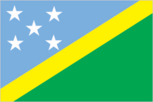
Flag description
divided diagonally by a thin yellow stripe from the lower hoist-side corner; the upper triangle (hoist side) is blue with five white five-pointed stars arranged in an X pattern; the lower triangle is green; blue represents the ocean; green the land; and yellow sunshine; the five stars stand for the five main island groups of the Solomon Islands
Government type
parliamentary democracy (National Parliament) under a constitutional monarchy; a Commonwealth realm
Independence
7 July 1978 (from the UK)
International law organization participation
has not submitted an ICJ jurisdiction declaration; non-party state to the ICCt
International organization participation
ACP, ADB, AOSIS, C, EITI (candidate country), ESCAP, FAO, G-77, IBRD, ICAO, ICRM, IDA, IFAD, IFC, IFRCS, ILO, IMF, IMO, IOC, ITU, MIGA, OPCW, PIF, Sparteca, SPC, UN, UNCTAD, UNESCO, UPU, WFTU, WHO, WMO, WTO
Judicial branch
- Court of Appeal (consists of the court president, and ex officio members to include the High Court chief justice and its puisne judges); High Court (consists of the chief justice and puisne judges as prescribed by the National Parliament) Court of Appeal and High Court president, chief justices, and puisne judges appointed by the governor-general upon recommendation of the Judicial and Legal Service Commission, chaired by the chief justice to include 5 members, mostly judicial officials and legal professionals; all judges appointed until retirement at age 60 Magistrates' Courts; Customary Land Appeal Court; local courts
- highest court(s)
- Court of Appeal (consists of the court president, and ex officio members to include the High Court chief justice and its puisne judges); High Court (consists of the chief justice and puisne judges as prescribed by the National Parliament)
- judge selection and term of office
- Court of Appeal and High Court president, chief justices, and puisne judges appointed by the governor-general upon recommendation of the Judicial and Legal Service Commission, chaired by the chief justice to include 5 members, mostly judicial officials and legal professionals; all judges appointed until retirement at age 60
- subordinate courts
- Magistrates' Courts; Customary Land Appeal Court; local courts
Legal system
mixed legal system of English common law and customary law
Legislative branch
- unicameral National Parliament (50 seats; members directly elected in single-seat constituencies by simple majority vote to serve 4-year terms) last held on 19 November 2014 (next to be held in 2018) percent of vote by party - UDP 10.7%, DAP 7.8%, PAP 4.4%, other 20.8%, independent 56.3%; seats by party - DAP 7, UDP 5, PAP 3, KPSI 1, SIPFP 1, SIPRA 1, independent 32
- description
- unicameral National Parliament (50 seats; members directly elected in single-seat constituencies by simple majority vote to serve 4-year terms)
- election results
- percent of vote by party - UDP 10.7%, DAP 7.8%, PAP 4.4%, other 20.8%, independent 56.3%; seats by party - DAP 7, UDP 5, PAP 3, KPSI 1, SIPFP 1, SIPRA 1, independent 32
- elections
- last held on 19 November 2014 (next to be held in 2018)
National anthem
- "God Save Our Solomon Islands" Panapasa BALEKANA and Matila BALEKANA/Panapasa BALEKANA adopted 1978
- lyrics/music
- Panapasa BALEKANA and Matila BALEKANA/Panapasa BALEKANA
- name
- "God Save Our Solomon Islands"
- note
- adopted 1978
National holiday
Independence Day, 7 July (1978)
National symbol(s)
- national colors: blue, yellow, green, white
- national colors
- blue, yellow, green, white
Political parties and leaders
- Democratic Alliance Party or DAP [Steve ABANA] Kadere Party of Solomon Islands or KPSI [Peter BOYERS] People's Alliance Party or PAP [Nathaniel WAENA] Solomon Islands People First Party or SIPFP [Dr. Jimmie RODGERS] Solomon Islands Party for Rural Advancement or SIPRA [Manasseh MAELANGA] United Democratic Party or UDP [Sir Thomas Ko CHAN] in general, Solomon Islands politics is characterized by fluid coalitions
- note
- in general, Solomon Islands politics is characterized by fluid coalitions
Political pressure groups and leaders
- Isatabu Freedom Movement or IFM Malaita Eagle Force or MEF these rival armed ethnic factions crippled the Solomon Islands in a wave of violence from 1999 to 2003
- note
- these rival armed ethnic factions crippled the Solomon Islands in a wave of violence from 1999 to 2003
Suffrage
21 years of age; universal
Economy
Agriculture - products
cocoa, coconuts, palm kernels, rice, fruit; cattle, pigs; fish; timber
Budget
- $428.2 million $453.4 million (2016 est.)
- expenditures
- $453.4 million (2016 est.)
- revenues
- $428.2 million
Budget surplus (+) or deficit (-)
-2.1% of GDP (2016 est.)
Commercial bank prime lending rate
10.1% (31 December 2016 est.) 10.48% (31 December 2015 est.)
Current account balance
$-49 million (2016 est.) $-36.1 million (2015 est.)
Debt - external
$491.5 million (31 December 2013 est.) $207.4 million (31 December 2015 est.)
Economy - overview
The bulk of the population depends on agriculture, fishing, and forestry for at least part of its livelihood. Most manufactured goods and petroleum products must be imported. The islands are rich in undeveloped mineral resources such as lead, zinc, nickel, and gold. Prior to the arrival of The Regional Assistance Mission to the Solomon Islands (RAMSI), severe ethnic violence, the closure of key businesses, and an empty government treasury culminated in economic collapse. RAMSI's efforts to restore law and order and economic stability have led to modest growth as the economy rebuilds.
Exchange rates
Solomon Islands dollars (SBD) per US dollar - 7.94 (2016 est.) 7.94 (2015 est.) 7.9147 (2014 est.) 7.3754 (2013 est.) 7.36 (2012 est.)
Exports
$419.9 million (2015 est.) $420.7 million (2015 est.)
Exports - commodities
timber, fish, copra, palm oil, cocoa
Exports - partners
China 62.4%, Italy 7%, UK 4.4% (2016)
Fiscal year
calendar year
GDP - composition, by sector of origin
- 34.4% 7.6% 58% (2016 est.)
- agriculture
- 34.4%
- industry
- 7.6%
- services
- 58% (2016 est.)
GDP - per capita (PPP)
- $2,100 (2016 est.) $2,100 (2015 est.) $2,100 (2014 est.) data are in 2016 dollars
- note
- data are in 2016 dollars
GDP - real growth rate
3.3% (2016 est.) 2.5% (2015 est.) 2.3% (2014 est.)
GDP (official exchange rate)
$1.233 billion (2016 est.)
GDP (purchasing power parity)
- $1.257 billion (2016 est.) $1.202 billion (2015 est.) $1.16 billion (2014 est.) data are in 2016 dollars
- note
- data are in 2016 dollars
Gross national saving
14% of GDP (2016 est.) 14.5% of GDP (2015 est.) 10.6% of GDP (2014 est.)
Household income or consumption by percentage share
- NA% NA%
- highest 10%
- NA%
- lowest 10%
- NA%
Imports
$425.7 million (2015 est.)
Imports - commodities
food, plant and equipment, manufactured goods, fuels, chemicals
Imports - partners
China 25.3%, Australia 15.5%, Singapore 9.6%, Malaysia 9.5%, Japan 5.2%, South Korea 5%, NZ 5%, Papua New Guinea 4.4% (2016)
Industrial production growth rate
3.2% (2016 est.)
Industries
fish (tuna), mining, timber
Inflation rate (consumer prices)
0.5% (2016 est.) -0.6% (2015 est.)
Labor force
202,500 (2007 est.)
Labor force - by occupation
- 75% 5% 20% (2000 est.)
- agriculture
- 75%
- industry
- 5%
- services
- 20% (2000 est.)
Population below poverty line
NA%
Public debt
9% of GDP (2016 est.) 10.5% of GDP (2015 est.)
Stock of broad money
$476.3 million (31 December 2016 est.) $427.4 million (31 December 2015 est.)
Stock of direct foreign investment - abroad
$50.1 million (31 December 2016 est.) $50.1 million (31 December 2015 est.)
Stock of direct foreign investment - at home
$571.2 million (31 December 2016 est.) $536.6 million (31 December 2015 est.)
Stock of domestic credit
$150.7 million (31 December 2016 est.) $84.69 million (31 December 2015 est.)
Stock of narrow money
$461 million (31 December 2016 est.) $405.7 million (31 December 2015 est.)
Taxes and other revenues
36.2% of GDP (2016 est.)
Unemployment rate
NA%
Energy
Carbon dioxide emissions from consumption of energy
300,000 Mt (2013 est.)
Crude oil - exports
0 bbl/day (2014 est.)
Crude oil - imports
0 bbl/day (2014 est.)
Crude oil - production
0 bbl/day (2016 est.)
Crude oil - proved reserves
0 bbl (1 January 2017 es)
Electricity - consumption
83.7 million kWh (2015 est.)
Electricity - exports
0 kWh (2016 est.)
Electricity - from fossil fuels
97.3% of total installed capacity (2015 est.)
Electricity - from hydroelectric plants
0% of total installed capacity (2015 est.)
Electricity - from nuclear fuels
0% of total installed capacity (2015 est.)
Electricity - from other renewable sources
5.4% of total installed capacity (2015 est.)
Electricity - imports
0 kWh (2016 est.)
Electricity - installed generating capacity
37,000 kW (2015 est.)
Electricity - production
90 million kWh (2015 est.)
Electricity access
- 495,321 23% 62% 13% (2012)
- electrification - rural areas
- 13% (2012)
- electrification - total population
- 23%
- electrification - urban areas
- 62%
- population without electricity
- 495,321
Natural gas - consumption
0 cu m (2013 est.)
Natural gas - exports
0 cu m (2013 est.)
Natural gas - imports
0 cu m (2013 est.)
Natural gas - production
0 cu m (2013 est.)
Natural gas - proved reserves
0 cu m (1 January 2014 es)
Refined petroleum products - consumption
1,600 bbl/day (2015 est.)
Refined petroleum products - exports
0 bbl/day (2014 est.)
Refined petroleum products - imports
1,554 bbl/day (2014 est.)
Refined petroleum products - production
0 bbl/day (2014 est.)
Communications
Broadcast media
Solomon Islands Broadcasting Corporation (SIBC) is the sole TV broadcaster with 1 station; multi-channel pay-TV is available; SIBC operates 2 national radio stations and 2 provincial stations; 2 local commercial radio stations; Radio Australia is available via satellite feed (2009)
Internet country code
.sb
Internet users
- 69,859 11.0% (July 2016 est.)
- percent of population
- 11.0% (July 2016 est.)
- total
- 69,859
Telephone system
- mobile-cellular telephone density is about 65 per 100 persons country code - 677; satellite earth station - 1 Intelsat (Pacific Ocean) (2016)
- domestic
- mobile-cellular telephone density is about 65 per 100 persons
- international
- country code - 677; satellite earth station - 1 Intelsat (Pacific Ocean) (2016)
Telephones - fixed lines
- 7,405 1 (July 2016 est.)
- subscriptions per 100 inhabitants
- 1 (July 2016 est.)
- total subscriptions
- 7,405
Telephones - mobile cellular
- 416,572 66 (July 2016 est.)
- subscriptions per 100 inhabitants
- 66 (July 2016 est.)
- total
- 416,572
Transportation
Airports
36 (2013)
Airports - with paved runways
- 1 (2013)
- 1,524 to 2,437 m
- 1 (2013)
- total
- 1
Airports - with unpaved runways
- 24 (2013)
- 1,524 to 2,437 m
- 1
- 914 to 1,523 m
- 10
- total
- 35
- under 914 m
- 24 (2013)
Civil aircraft registration country code prefix
H4 (2016)
Heliports
3 (2013)
National air transport system
- 373,738 3,691,584 mt-km (2015)
- annual freight traffic on registered air carriers
- 3,691,584 mt-km (2015)
- annual passenger traffic on registered air carriers
- 373,738
- inventory of registered aircraft operated by air carriers
- 3
- number of registered air carriers
- 1
Ports and terminals
- Honiara, Malloco Bay, Viru Harbor, Tulaghi
- major seaport(s)
- Honiara, Malloco Bay, Viru Harbor, Tulaghi
Roadways
- 1,390 km 34 km 1,356 km includes 920 km of private plantation roads (2011)
- note
- includes 920 km of private plantation roads (2011)
- paved
- 34 km
- total
- 1,390 km
- unpaved
- 1,356 km
Military and Security
Military branches
no regular military forces; Royal Solomon Islands Police Force (2013)
Transnational Issues
Disputes - international
since 2003, the Regional Assistance Mission to Solomon Islands, consisting of police, military, and civilian advisors drawn from 15 countries, has assisted in reestablishing and maintaining civil and political order while reinforcing regional stability and security
Trafficking in persons
- the Solomon Islands is a source and destination country for local adults and children and Southeast Asian men and women subjected to forced labor and forced prostitution; women from China, Indonesia, Malaysia, and the Philippines are recruited for legitimate work and upon arrival are forced into prostitution; men from Indonesia and Malaysia recruited to work in the Solomon Islands’ mining and logging industries may be subjected to forced labor; local children are forced into prostitution near foreign logging camps, on fishing vessels, at hotels, and entertainment venues; some local children are also sold by their parents for marriage to foreign workers or put up for “informal adoption” to pay off debts and then find themselves forced into domestic servitude or forced prostitution Tier 2 Watch List – the Solomon Islands does not fully comply with the minimum standards for the elimination of trafficking; however, it is making significant efforts to do so; in 2014, the Solomon Islands was granted a waiver from an otherwise required downgrade to Tier 3 because its government has a written plan that, if implemented, would constitute making significant efforts to bring itself into compliance with the minimum standards for the elimination of trafficking; the government gazetted implementing regulations for the 2012 immigration act prohibiting transnational trafficking, but the penalties are not sufficiently stringent because they allow the option of paying a fine; a new draft law to address these weaknesses awaits parliamentary review; no new trafficking investigations were conducted, even after labor inspections at logging and fishing companies, no existing cases led to prosecutions or convictions, and no funding was allocated for national anti-trafficking efforts; authorities did not identify or protect any victims and lack any procedures or shelters to do so; civil society and religious organizations provide most of the limited services available; a lack of understanding of the crime of trafficking remains a serious challenge (2015)
- current situation
- the Solomon Islands is a source and destination country for local adults and children and Southeast Asian men and women subjected to forced labor and forced prostitution; women from China, Indonesia, Malaysia, and the Philippines are recruited for legitimate work and upon arrival are forced into prostitution; men from Indonesia and Malaysia recruited to work in the Solomon Islands’ mining and logging industries may be subjected to forced labor; local children are forced into prostitution near foreign logging camps, on fishing vessels, at hotels, and entertainment venues; some local children are also sold by their parents for marriage to foreign workers or put up for “informal adoption” to pay off debts and then find themselves forced into domestic servitude or forced prostitution
- tier rating
- Tier 2 Watch List – the Solomon Islands does not fully comply with the minimum standards for the elimination of trafficking; however, it is making significant efforts to do so; in 2014, the Solomon Islands was granted a waiver from an otherwise required downgrade to Tier 3 because its government has a written plan that, if implemented, would constitute making significant efforts to bring itself into compliance with the minimum standards for the elimination of trafficking; the government gazetted implementing regulations for the 2012 immigration act prohibiting transnational trafficking, but the penalties are not sufficiently stringent because they allow the option of paying a fine; a new draft law to address these weaknesses awaits parliamentary review; no new trafficking investigations were conducted, even after labor inspections at logging and fishing companies, no existing cases led to prosecutions or convictions, and no funding was allocated for national anti-trafficking efforts; authorities did not identify or protect any victims and lack any procedures or shelters to do so; civil society and religious organizations provide most of the limited services available; a lack of understanding of the crime of trafficking remains a serious challenge (2015)