1996 Edition
CIA World Factbook 1996 (Project Gutenberg)
Introduction
Description
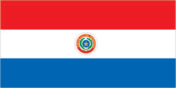
three equal, horizontal bands of red (top), white, and blue with an emblem centered in the white band; unusual flag in that the emblem is different on each side; the obverse (hoist side at the left) bears the national coat of arms (a yellow five-pointed star within a green wreath capped by the words REPUBLICA DEL PARAGUAY, all within two circles); the reverse (hoist side at the right) bears the seal of the treasury (a yellow lion below a red Cap of Liberty and the words Paz y Justicia (Peace and Justice) capped by the words REPUBLICA DEL PARAGUAY, all within two circles)
Location
23 00 S, 58 00 W -- Central South America, northeast of Argentina Flag ----
Geography
Area
- comparative area
- slightly smaller than California
- land area
- 397,300 sq km
- total area
- 406,750 sq km
Climate
subtropical; substantial rainfall in the eastern portions, becoming semiarid in the far west
Coastline
0 km (landlocked)
Environment
- current issues
- deforestation (an estimated 2 million hectares of forest land have been lost from 1958-85); water pollution; inadequate means for waste disposal present health risks for many urban residents
- international agreements
- party to - Biodiversity, Climate Change, Endangered Species, Law of the Sea, Ozone Layer Protection; signed, but not ratified - Desertification, Hazardous Wastes, Nuclear Test Ban, Wetlands
- natural hazards
- local flooding in southeast (early September to June); poorly drained plains may become boggy (early October to June)
Geographic coordinates
23 00 S, 58 00 W
Geographic note
landlocked; lies between Argentina, Bolivia, and Brazil
International disputes
short section of the boundary with Brazil, just west of Salto del Guaira (Guaira Falls) on the Rio Parana, has not been determined
Irrigated land
670 sq km (1989 est.)
Land boundaries
- border countries
- Argentina 1,880 km, Bolivia 750 km, Brazil 1,290 km
- total
- 3,920 km
Land use
- arable land
- 20%
- forest and woodland
- 35%
- meadows and pastures
- 39%
- other
- 5%
- permanent crops
- 1%
Location
Central South America, northeast of Argentina
Map references
South America
Maritime claims
none (landlocked)
Natural resources
hydropower, timber, iron ore, manganese, limestone
Terrain
- grassy plains and wooded hills east of Rio Paraguay; Gran Chaco region west of Rio Paraguay mostly low, marshy plain near the river, and dry forest and thorny scrub elsewhere
- highest point
- Cerro San Rafael 850 m
- lowest point
- junction of Rio Paraguay and Rio Parana 46 m
People and Society
Age structure
0-14 years: 41% (male 1,144,644; female 1,096,430) 15-64 years: 55% (male 1,518,661; female 1,513,577) 65 years and over: 4% (male 106,121; female 124,713) (July 1996 est.)
Birth rate
30.97 births/1,000 population (1996 est.)
Death rate
4.31 deaths/1,000 population (1996 est.)
Ethnic divisions
mestizo (mixed Spanish and Indian) 95%, whites plus Amerindians 5%
Infant mortality rate
23.2 deaths/1,000 live births (1996 est.)
Languages
Spanish (official), Guarani
Life expectancy at birth
- female
- 75.43 years (1996 est.)
- male
- 72.33 years
- total population
- 73.84 years
Literacy
- age 15 and over can read and write (1995 est.)
- female
- 90.6%
- male
- 93.5%
- total population
- 92.1%
Nationality
- adjective
- Paraguayan
- noun
- Paraguayan(s)
Net migration rate
0 migrant(s)/1,000 population (1996 est.)
Population
5,504,146 (July 1996 est.)
Population growth rate
2.67% (1996 est.)
Religions
Roman Catholic 90%, Mennonite and other Protestant denominations
Sex ratio
- all ages
- 1.01 male(s)/female (1996 est.)
- at birth
- 1.05 male(s)/female
- under 15 years
- 1.04 male(s)/female 15-64 years: 1 male(s)/female 65 years and over: 0.85 male(s)/female
Total fertility rate
4.15 children born/woman (1996 est.)
Government
Administrative divisions
17 departments (departamentos, singular - departamento); Alto Paraguay, Alto Parana, Amambay, Boqueron, Caaguazu, Caazapa, Canindeyu, Central, Concepcion, Cordillera, Guaira, Itapua, Misiones, Neembucu, Paraguari, Presidente Hayes, San Pedro
Capital
Asuncion
Chamber of Deputies (Camara de Diputados)
elections last held 9 May 1993 (next to be held by May 1998); results - percent of vote by party NA; seats - (80 total) Colorado Party 38, PLRA 33, EN 9
Chamber of Senators (Camara de Senadores)
elections last held 9 May 1993 (next to be held NA May 1998); results - percent of vote by party NA; seats - (45 total) Colorado Party 20, PLRA 17, EN 8
Constitution
promulgated 20 June 1992
Data code
PA
Diplomatic representation in US
- chancery
- 2400 Massachusetts Avenue NW, Washington, DC 20008
- chief of mission
- Ambassador Jorge PRIETO CONTI
- telephone
- [1] (202) 483-6960 through 6962
Executive branch
- cabinet
- Council of Ministers was nominated by the president
- chief of state and head of government
- President Juan Carlos WASMOSY (since 15 August 1993) and Vice President Roberto Angel SEIFART (since 15 August 1993) were elected for five-year terms by popular vote; election last held 9 May 1993 (next to be held NA May 1998); results - Juan Carlos WASMOSY 40.09%, Domingo LAINO 32.06%, Guillermo CABALLERO VARGAS 23.04%
FAX
- [1] (202) 234-4508
- [595] (21) 213-728
- consulate(s) general
- Miami and New York
Flag
three equal, horizontal bands of red (top), white, and blue with an emblem centered in the white band; unusual flag in that the emblem is different on each side; the obverse (hoist side at the left) bears the national coat of arms (a yellow five-pointed star within a green wreath capped by the words REPUBLICA DEL PARAGUAY, all within two circles); the reverse (hoist side at the right) bears the seal of the treasury (a yellow lion below a red Cap of Liberty and the words Paz y Justicia (Peace and Justice) capped by the words REPUBLICA DEL PARAGUAY, all within two circles)
Independence
14 May 1811 (from Spain)
International organization participation
AG (observer), CCC, ECLAC, FAO, G-77, IADB, IAEA, IBRD, ICAO, ICFTU, ICRM, IDA, IFAD, IFC, IFRCS, ILO, IMF, IMO, Intelsat, Interpol, IOC, IOM, ITU, LAES, LAIA, Mercosur, OAS, OPANAL, PCA, RG, UN, UNCTAD, UNESCO, UNIDO, UPU, WCL, WHO, WIPO, WMO, WToO, WTrO
Judicial branch
Supreme Court of Justice (Corte Suprema de Justicia), judges appointed on the proposal of the Counsel of Magistrates (Consejo de la Magistratura)
Legal system
based on Argentine codes, Roman law, and French codes; judicial review of legislative acts in Supreme Court of Justice; does not accept compulsory ICJ jurisdiction
Legislative branch
bicameral Congress (Congreso)
Name of country
- conventional long form
- Republic of Paraguay
- conventional short form
- Paraguay
- local long form
- Republica del Paraguay
- local short form
- Paraguay
National holiday
Independence Days, 14-15 May (1811)
Other political or pressure groups
Confederation of Workers (CUT); Roman Catholic Church
Political parties and leaders
Colorado Party, Luis Maria ARGANA, president; Authentic Radical Liberal Party (PLRA), Domingo LAINO; National Encounter (EN), Guillermo CABALLERO VARGAS; Christian Democratic Party (PDC), Miguel MONTANER; Febrerista Revolutionary Party (PRF), Euclides ACEVEDO; Popular Democratic Party (PDP), Hugo RICHER
Suffrage
18 years of age; universal and compulsory up to age 60
Type of government
republic
US diplomatic representation
- chief of mission
- Ambassador Robert E. SERVICE
- embassy
- 1776 Avenida Mariscal Lopez, Casilla Postal 402, Asuncion
- mailing address
- Unit 4711, APO AA 34036-0001
- telephone
- [595] (21) 213-715
Economy
Agriculture
cotton, sugarcane, soybeans, corn, wheat, tobacco, cassava (tapioca), fruits, vegetables; beef, pork, eggs, milk; timber
Budget
- expenditures
- $1.66 billion, including capital expenditures of $NA (1995 est.)
- revenues
- $1.25 billion (1995 est.)
Currency
1 guarani (G) = 100 centimos
Economic aid
- recipient
- ODA, $38 million (1993)
Economic overview
Paraguay has a market economy marked by a large informal sector. The formal economy is largely oriented toward services, but 45% of the population derive their living from agricultural activity, often on a subsistence basis. The economy has grown an average of 3% to 4% over the past five years. Population has increased at 3% a year over the same period leaving per capita income nearly stagnant. The informal sector is marked by both reexport of imported consumer goods (electronics, whiskeys, perfumes, cigarettes and office equipment) to neighboring countries as well as by the activities of thousands of microenterprises and urban street vendors. The Paraguayan Government has stated publicly that it will continue its economic reform agenda in close coordination with its Mercosur (Southern Cone Common Market) partners. In 1995, the government also promised to undertake efforts to formalize the financial sector, after a financial shock forced the bail-out of the second and third largest banks. Paraguay's continued integration into Mercosur also offers potential for growth; it is closely linked with the success of foreign investment promotion. Non-traditional exports, such as finished agricultural products, light manufactures, and small consumer items, are growing rapidly. Government reform efforts, including privatization, have continued, but with little success in 1995.
Electricity
- capacity
- 6,530,000 kW
- consumption per capita
- NA
- note
- much of the electricity produced in Paraguay is exported to Brazil and domestic consumption cannot be determined
- production
- 26.5 billion kWh (1992)
Exchange rates
guaranies (G) per US$ - 2,003.8 (January 1996), 1,970.4 (1995), 1,911.5 (1994), 1,744.3 (1993), 1,500.3 (1992), 1,325.2 (1991)
Exports
- $819.5 million (f.o.b., 1995)
- commodities
- cotton, soybeans, timber, vegetable oils, meat products, coffee, tung oil
- partners
- EU 37%, Brazil 25%, Argentina 10%, Chile 6%, US 6%
External debt
$1.38 billion (yearend 1995)
Fiscal year
calendar year
GDP
purchasing power parity - $17 billion (1995 est.)
GDP composition by sector
- agriculture
- 25.7%
- industry
- 25.8%
- services
- 48.5% (1994)
GDP per capita
$3,200 (1995 est.)
GDP real growth rate
4.2% (1995 est.)
Illicit drugs
illicit producer of cannabis for the international drug trade; transshipment point for Bolivian cocaine headed for Europe and the US
Imports
- $2.871 billion (c.i.f., 1995)
- commodities
- capital goods, foodstuffs, consumer goods, raw materials, fuels
- partners
- Brazil 30%, EU 20%, US 18%, Argentina 8%, Japan 7%
Industrial production growth rate
1.3% (1995 est.)
Industries
meat packing, oilseed crushing, milling, brewing, textiles, other light consumer goods, cement, construction
Inflation rate (consumer prices)
10.5% (1995)
Labor force
- 1.692 million (1993 est.)
- by occupation
- agriculture 45%
Unemployment rate
12% (1995)
Communications
Branches
Army, Navy (includes Naval Air and Marines), Air Force
Defense expenditures
exchange rate conversion - $94 million, 0.6% of GDP (1994)
Manpower availability
- males age 15-49
- 1,334,638
- males fit for military service
- 968,297
- males reach military age (17) annually
- 58,398 (1996 est.)
Radio broadcast stations
AM 40, FM 0, shortwave 7
Radios
775,000 (1992 est.)
Telephone system
- meager telephone service; principal switching center is Asuncion
- domestic
- fair microwave radio relay network
- international
- satellite earth station - 1 Intelsat (Atlantic Ocean)
Telephones
88,730 (1985 est.)
Television broadcast stations
5
Televisions
370,000 (1992 est.) Defense
Transportation
Airports
- total
- 739
- with paved runways 1 524 to 2 437 m
- 2
- with paved runways 914 to 1 523 m
- 4
- with paved runways over 3 047 m
- 3
- with paved runways under 914 m
- 438
- with unpaved runways 1 524 to 2 437 m
- 25
- with unpaved runways 914 to 1 523 m
- 266 (1995 est.)
- with unpaved runways over 3 047 m
- 1
Highways
- paved
- 1,778 km
- total
- 21,834 km
- unpaved
- 20,056 km (1987 est.)
Merchant marine
- ships by type
- cargo 13, oil tanker 2, roll-on/roll-off 1 (1995 est.)
- total
- 16 ships (1,000 GRT or over) totaling 21,323 GRT/23,907 DWT
Ports
Asuncion, Villeta, San Antonio, Encarnacion
Railways
- narrow gauge
- 60 km 1.000-m gauge
- other
- 470 km various gauges (privately owned)
- standard gauge
- 441 km 1.435-m gauge
- total
- 971 km
Waterways
3,100 km