2012 Edition
CIA World Factbook 2012 Archive (HTML)
Introduction
Background
The eastern half of the island of New Guinea - second largest in the world - was divided between Germany (north) and the UK (south) in 1885. The latter area was transferred to Australia in 1902, which occupied the northern portion during World War I and continued to administer the combined areas until independence in 1975. A nine-year secessionist revolt on the island of Bougainville ended in 1997 after claiming some 20,000 lives.
Geography
Area
- 462,840 sq km 452,860 sq km 9,980 sq km
- total
- 462,840 sq km
- water
- 9,980 sq km
Area - comparative
slightly larger than California
Climate
tropical; northwest monsoon (December to March), southeast monsoon (May to October); slight seasonal temperature variation
Coastline
5,152 km
Elevation extremes
- Pacific Ocean 0 m Mount Wilhelm 4,509 m
- highest point
- Mount Wilhelm 4,509 m
- lowest point
- Pacific Ocean 0 m
Environment - current issues
rain forest subject to deforestation as a result of growing commercial demand for tropical timber; pollution from mining projects; severe drought
Environment - international agreements
- Antarctic Treaty, Biodiversity, Climate Change, Climate Change-Kyoto Protocol, Desertification, Endangered Species, Environmental Modification, Hazardous Wastes, Law of the Sea, Marine Dumping, Ozone Layer Protection, Ship Pollution, Tropical Timber 83, Tropical Timber 94, Wetlands none of the selected agreements
- party to
- Antarctic Treaty, Biodiversity, Climate Change, Climate Change-Kyoto Protocol, Desertification, Endangered Species, Environmental Modification, Hazardous Wastes, Law of the Sea, Marine Dumping, Ozone Layer Protection, Ship Pollution, Tropical Timber 83, Tropical Timber 94, Wetlands
- signed, but not ratified
- none of the selected agreements
Freshwater withdrawal (domestic/industrial/agricultural)
- 0.1 cu km/yr (56%/43%/1%) 17 cu m/yr (1987)
- per capita
- 17 cu m/yr (1987)
- total
- 0.1 cu km/yr (56%/43%/1%)
Geographic coordinates
6 00 S, 147 00 E
Geography - note
shares island of New Guinea with Indonesia; one of world's largest swamps along southwest coast
Irrigated land
NA
Land boundaries
- 820 km Indonesia 820 km
- border countries
- Indonesia 820 km
- total
- 820 km
Land use
- 0.49% 1.4% 98.11% (2005)
- arable land
- 0.49%
- other
- 98.11% (2005)
- permanent crops
- 1.4%
Location
Oceania, group of islands including the eastern half of the island of New Guinea between the Coral Sea and the South Pacific Ocean, east of Indonesia
Map references
Oceania
Maritime claims
- measured from claimed archipelagic baselines 12 nm 200 m depth or to the depth of exploitation 200 nm
- continental shelf
- 200 m depth or to the depth of exploitation
- exclusive fishing zone
- 200 nm
- territorial sea
- 12 nm
Natural hazards
- active volcanism; situated along the Pacific "Ring of Fire"; the country is subject to frequent and sometimes severe earthquakes; mud slides; tsunamis severe volcanic activity; Ulawun (elev. 2,334 m), one of Papua New Guinea's potentially most dangerous volcanoes, has been deemed a "Decade Volcano" by the International Association of Volcanology and Chemistry of the Earth's Interior, worthy of study due to its explosive history and close proximity to human populations; Rabaul (elev. 688 m) destroyed the city of Rabaul in 1937 and 1994; Lamington erupted in 1951 killing 3,000 people; Manam's 2004 eruption forced the island's abandonment; other historically active volcanoes include Bam, Bagana, Garbuna, Karkar, Langila, Lolobau, Long Island, Pago, St. Andrew Strait, Victory, and Waiowa
- volcanism
- severe volcanic activity; Ulawun (elev. 2,334 m), one of Papua New Guinea's potentially most dangerous volcanoes, has been deemed a "Decade Volcano" by the International Association of Volcanology and Chemistry of the Earth's Interior, worthy of study due to its explosive history and close proximity to human populations; Rabaul (elev. 688 m) destroyed the city of Rabaul in 1937 and 1994; Lamington erupted in 1951 killing 3,000 people; Manam's 2004 eruption forced the island's abandonment; other historically active volcanoes include Bam, Bagana, Garbuna, Karkar, Langila, Lolobau, Long Island, Pago, St. Andrew Strait, Victory, and Waiowa
Natural resources
gold, copper, silver, natural gas, timber, oil, fisheries
Terrain
mostly mountains with coastal lowlands and rolling foothills
Total renewable water resources
801 cu km (1987)
People and Society
Age structure
- 35.9% (male 1,153,908/ female 1,114,109) 60.3% (male 1,955,028/ female 1,851,584) 3.7% (male 125,449/ female 110,051) (2012 est.)
- 0-14 years
- 35.9% (male 1,153,908/ female 1,114,109)
- 15-64 years
- 60.3% (male 1,955,028/ female 1,851,584)
- 65 years and over
- 3.7% (male 125,449/ female 110,051) (2012 est.)
Birth rate
25.92 births/1,000 population (2012 est.)
Children under the age of 5 years underweight
18.1% (2005)
Death rate
6.56 deaths/1,000 population (July 2012 est.)
Education expenditures
NA
Ethnic groups
Melanesian, Papuan, Negrito, Micronesian, Polynesian
Health expenditures
3.1% of GDP (2009)
HIV/AIDS - adult prevalence rate
0.9% (2009 est.)
HIV/AIDS - deaths
1,300 (2009 est.)
HIV/AIDS - people living with HIV/AIDS
34,000 (2009 est.)
Infant mortality rate
- 42.05 deaths/1,000 live births 45.8 deaths/1,000 live births 38.11 deaths/1,000 live births (2012 est.)
- female
- 38.11 deaths/1,000 live births (2012 est.)
- total
- 42.05 deaths/1,000 live births
Languages
Tok Pisin (official), English (official), Hiri Motu (official), some 860 indigenous languages spoken (over 12% of the world's total); most languages have fewer than 1,000 speakers Tok Pisin, a creole language, is widely used and understood; English is spoken by 1%-2%; Hiri Motu is spoken by less than 2%
Life expectancy at birth
- 66.46 years 64.23 years 68.79 years (2012 est.)
- female
- 68.79 years (2012 est.)
- total population
- 66.46 years
Literacy
- age 15 and over can read and write 57.3% 63.4% 50.9% (2000 census)
- definition
- age 15 and over can read and write
- female
- 50.9% (2000 census)
- male
- 63.4%
- total population
- 57.3%
Major cities - population
PORT MORESBY (capital) 314,000 (2009)
Major infectious diseases
- very high bacterial diarrhea, hepatitis A, and typhoid fever dengue fever and malaria (2009)
- degree of risk
- very high
- food or waterborne diseases
- bacterial diarrhea, hepatitis A, and typhoid fever
- vectorborne diseases
- dengue fever and malaria (2009)
Maternal mortality rate
230 deaths/100,000 live births (2010)
Median age
- 22 years 22.3 years 21.8 years (2012 est.)
- female
- 21.8 years (2012 est.)
- male
- 22.3 years
- total
- 22 years
Nationality
- Papua New Guinean(s) Papua New Guinean
- adjective
- Papua New Guinean
- noun
- Papua New Guinean(s)
Net migration rate
0 migrant(s)/1,000 population (2012 est.)
People - note
the indigenous population of Papua New Guinea is one of the most heterogeneous in the world; PNG has several thousand separate communities, most with only a few hundred people; divided by language, customs, and tradition, some of these communities have engaged in low-scale tribal conflict with their neighbors for millennia; the advent of modern weapons and modern migrants into urban areas has greatly magnified the impact of this lawlessness
Physicians density
0.053 physicians/1,000 population (2008)
Population
6,310,129 (July 2012 est.)
Population growth rate
1.936% (2012 est.)
Religions
Roman Catholic 27%, Protestant 69.4% (Evangelical Lutheran 19.5%, United Church 11.5%, Seventh-Day Adventist 10%, Pentecostal 8.6%, Evangelical Alliance 5.2%, Anglican 3.2%, Baptist 2.5%, other Protestant 8.9%), Baha'i 0.3%, indigenous beliefs and other 3.3% (2000 census)
Sanitation facility access
- urban: 71% of population rural: 41% of population total: 45% of population urban: 29% of population rural: 59% of population total: 55% of population
- rural
- 59% of population
- total
- 55% of population
- urban
- 29% of population
Sex ratio
- 1.05 male(s)/female 1.04 male(s)/female 1.06 male(s)/female 1.14 male(s)/female 1.05 male(s)/female (2011 est.)
- 15-64 years
- 1.06 male(s)/female
- 65 years and over
- 1.14 male(s)/female
- at birth
- 1.05 male(s)/female
- total population
- 1.05 male(s)/female (2011 est.)
- under 15 years
- 1.04 male(s)/female
Total fertility rate
3.39 children born/woman (2012 est.)
Urbanization
- 13% of total population (2010) 2.9% annual rate of change (2010-15 est.)
- rate of urbanization
- 2.9% annual rate of change (2010-15 est.)
- urban population
- 13% of total population (2010)
Government
Administrative divisions
18 provinces, 1 autonomous region*, and 1 district**; Bougainville*, Central, Chimbu, Eastern Highlands, East New Britain, East Sepik, Enga, Gulf, Madang, Manus, Milne Bay, Morobe, National Capital**, New Ireland, Northern, Sandaun, Southern Highlands, Western, Western Highlands, West New Britain Hela and Jiwaka were approved as separate provinces on 17 May 2012
Capital
- Port Moresby 9 27 S, 147 11 E UTC+10 (15 hours ahead of Washington, DC during Standard Time)
- geographic coordinates
- 9 27 S, 147 11 E
- name
- Port Moresby
- time difference
- UTC+10 (15 hours ahead of Washington, DC during Standard Time)
Constitution
16 September 1975
Country name
- Independent State of Papua New Guinea Papua New Guinea Papuaniugini Territory of Papua and New Guinea PNG
- abbreviation
- PNG
- conventional long form
- Independent State of Papua New Guinea
- conventional short form
- Papua New Guinea
- former
- Territory of Papua and New Guinea
- local short form
- Papuaniugini
Diplomatic representation from the US
- Ambassador Walter E. NORTH Douglas Street, Port Moresby, N.C.D. 4240 Port Moresby PI, US Department of State, Washington DC 20521-4240 [675] 321-1455 [675] 321-3423
- chief of mission
- Ambassador Walter E. NORTH
- embassy
- Douglas Street, Port Moresby, N.C.D.
- FAX
- [675] 321-3423
- mailing address
- 4240 Port Moresby PI, US Department of State, Washington DC 20521-4240
- telephone
- [675] 321-1455
Diplomatic representation in the US
- Ambassador (vacant); Charge d'Affaires Elias Rahuromo WOHENGU 1779 Massachusetts Avenue NW, Suite 805, Washington, DC 20036 [1] (202) 745-3680 [1] (202) 745-3679
- chancery
- 1779 Massachusetts Avenue NW, Suite 805, Washington, DC 20036
- chief of mission
- Ambassador (vacant); Charge d'Affaires Elias Rahuromo WOHENGU
- FAX
- [1] (202) 745-3679
- telephone
- [1] (202) 745-3680
Executive branch
- Queen ELIZABETH II (since 6 February 1952); represented by Governor Michael OGIO (since 25 February 2011) Prime Minister Peter Paire O'NEILL (since 2 August 2011); Deputy Prime Minister Leo DION (since 9 August 2012) National Executive Council appointed by the governor general on the recommendation of the prime minister the monarchy is hereditary; the governor general nominated by parliament and appointed by the chief of state; following legislative elections, the leader of the majority party or leader of the majority coalition usually appointed prime minister by the governor general acting in accordance with a decision of the parliament; Peter Paire O'NEILL elected prime minister by parliament on 3 August 2012 by a vote of 94 to 12
- cabinet
- National Executive Council appointed by the governor general on the recommendation of the prime minister
- chief of state
- Queen ELIZABETH II (since 6 February 1952); represented by Governor Michael OGIO (since 25 February 2011)
- elections
- the monarchy is hereditary; the governor general nominated by parliament and appointed by the chief of state; following legislative elections, the leader of the majority party or leader of the majority coalition usually appointed prime minister by the governor general acting in accordance with a decision of the parliament; Peter Paire O'NEILL elected prime minister by parliament on 3 August 2012 by a vote of 94 to 12
- head of government
- Prime Minister Peter Paire O'NEILL (since 2 August 2011); Deputy Prime Minister Leo DION (since 9 August 2012)
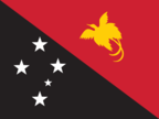
Flag description
divided diagonally from upper hoist-side corner; the upper triangle is red with a soaring yellow bird of paradise centered; the lower triangle is black with five, white, five-pointed stars of the Southern Cross constellation centered; red, black, and yellow are traditional colors of Papua New Guinea; the bird of paradise - endemic to the island of New Guinea - is an emblem of regional tribal culture and represents the emergence of Papua New Guinea as a nation; the Southern Cross, visible in the night sky, symbolizes Papua New Guinea's connection with Australia and several other countries in the South Pacific
Government type
constitutional parliamentary democracy and a Commonwealth realm
Independence
16 September 1975 (from the Australian-administered UN trusteeship)
International law organization participation
has not submitted an ICJ jurisdiction declaration; non-party state to the ICCt
International organization participation
ACP, ADB, AOSIS, APEC, ARF, ASEAN (observer), C, CD, CP, FAO, G-77, IAEA, IBRD, ICAO, ICRM, IDA, IFAD, IFC, IFRCS, IHO, ILO, IMF, IMO, Interpol, IOC, IOM (observer), IPU, ISO (correspondent), ITSO, ITU, MIGA, NAM, OPCW, PIF, Sparteca, SPC, UN, UNCTAD, UNESCO, UNIDO, UNMISS, UNWTO, UPU, WCO, WFTU (NGOs), WHO, WIPO, WMO, WTO
Judicial branch
Supreme Court (the chief justice is appointed by the governor general on the proposal of the National Executive Council after consultation with the minister responsible for justice; other judges are appointed by the Judicial and Legal Services Commission)
Legal system
mixed legal system of English common law and customary law
Legislative branch
- unicameral National Parliament (109 seats, 89 filled from open electorates and 20 from provinces and national capital district; members elected by popular vote to serve five-year terms); constitution allows up to 126 seats last held from 23 June 2012 to 27 July 2012 (next to be held in June 2017) percent of vote by party - NA; seats by party - People's National Congress Party 27, Triumph Heritage Empowerment Party 12, PNG Party 8, National Alliance Party 7, United Resources Party 7, People's Party 6, People's Progess Party 6, other parties 22, independents 16 14 other parties won 3 or fewer seats; association with political parties is fluid
- election results
- percent of vote by party - NA; seats by party - People's National Congress Party 27, Triumph Heritage Empowerment Party 12, PNG Party 8, National Alliance Party 7, United Resources Party 7, People's Party 6, People's Progess Party 6, other parties 22, independents 16
- elections
- last held from 23 June 2012 to 27 July 2012 (next to be held in June 2017)
National anthem
- "O Arise All You Sons" Thomas SHACKLADY adopted 1975
- lyrics/music
- Thomas SHACKLADY
- name
- "O Arise All You Sons"
National holiday
Independence Day, 16 September (1975)
National symbol(s)
bird of paradise
Political parties and leaders
National Alliance Party or NA [Patrick PRUAITCHI]; Papua New Guinea Party or PNGP [Beldan NEMAH]; People's National Congress Party or PNC [Peter O'NEILL]; People's Party or PP; People's Progress Party or PPP; Triumph Heritage Empowerment Party or THE [Don Poyle]; United Resources Party or URP [William DUMA] as of 13 March 2012, 41 political parties were registered
Political pressure groups and leaders
Centre for Environment Law and Community Rights or Celcor [Damien ASE]; Community Coalition Against Corruption; National Council of Women; Transparency International PNG
Suffrage
18 years of age; universal
Economy
Agriculture - products
coffee, cocoa, copra, palm kernels, tea, sugar, rubber, sweet potatoes, fruit, vegetables, vanilla; poultry, pork; shellfish
Budget
- $4.962 billion $4.942 billion (2012 est.)
- expenditures
- $4.942 billion (2012 est.)
- revenues
- $4.962 billion
Budget surplus (+) or deficit (-)
0.1% of GDP (2012 est.)
Central bank discount rate
14% (31 December 2010 est.) 6.92% (31 December 2009 est.)
Commercial bank prime lending rate
11.3% (31 December 2012 est.) 10.81% (31 December 2011 est.)
Current account balance
-$4.381 billion (2012 est.) -$48.5 million (2011 est.)
Debt - external
$4.86 billion (31 December 2012 est.) $5.144 billion (31 December 2011 est.)
Distribution of family income - Gini index
50.9 (1996)
Economy - overview
Papua New Guinea (PNG) is richly endowed with natural resources, but exploitation has been hampered by rugged terrain, land tenure issues, and the high cost of developing infrastructure. The economy has a small formal sector, focused mainly on the export of those natural resources, and an informal sector, employing the majority of the population. Agriculture provides a subsistence livelihood for 85% of the people. Mineral deposits, including copper, gold, and oil, account for nearly two-thirds of export earnings. Natural gas reserves amount to an estimated 227 billion cubic meters. A consortium led by a major American oil company is constructing a liquefied natural gas (LNG) production facility that could begin exporting in 2014. As the largest investment project in the country's history, it has the potential to double GDP in the near-term and triple Papua New Guinea's export revenue. An American-owned firm also opened PNG's first oil refinery in 2004 and is building a second LNG production facility. The government faces the challenge of ensuring transparency and accountability for revenues flowing from this and other large LNG projects. In 2011 and 2012, the National Parliament passed legislation that created an offshore Sovereign Wealth Fund (SWF) to manage government surpluses from mineral, oil, and natural gas projects. In recent years, the government has opened up markets in telecommunications and air transport, making both more affordable to the people. Numerous challenges still face the government of Peter O'NEILL, including providing physical security for foreign investors, regaining investor confidence, restoring integrity to state institutions, promoting economic efficiency by privatizing moribund state institutions, and maintaining good relations with Australia, its former colonial ruler. Other socio-cultural challenges could upend the economy including chronic law and order and land tenure issues. The global financial crisis had little impact because of continued foreign demand for PNG's commodities.
Exchange rates
kina (PGK) per US dollar - 2.078 (2012 est.) 2.371 (2011 est.) 2.7193 (2010 est.) 2.7551 (2009) 2.6956 (2008)
Exports
$7.362 billion (2012 est.) $6.791 billion (2011 est.)
Exports - commodities
oil, gold, copper ore, logs, palm oil, coffee, cocoa, crayfish, prawns
Exports - partners
Australia 31.5%, Japan 7%, China 6.2% (2011)
Fiscal year
calendar year
GDP - composition by sector
- 27.9% 38.5% 33.6% (2012 est.)
- agriculture
- 27.9%
- industry
- 38.5%
- services
- 33.6% (2012 est.)
GDP - per capita (PPP)
$2,700 (2012 est.) $2,600 (2011 est.) $2,400 (2010 est.) data are in 2012 US dollars
GDP - real growth rate
7.7% (2012 est.) 8.9% (2011 est.) 7.6% (2010 est.)
GDP (official exchange rate)
$15.39 billion (2012 est.)
GDP (purchasing power parity)
$18.45 billion (2012 est.) $17.14 billion (2011 est.) $15.74 billion (2010 est.) data are in 2012 US dollars
Household income or consumption by percentage share
- 1.7% 40.5% (1996)
- highest 10%
- 40.5% (1996)
- lowest 10%
- 1.7%
Imports
$5.269 billion (2012 est.) $4.07 billion (2011 est.)
Imports - commodities
machinery and transport equipment, manufactured goods, food, fuels, chemicals
Imports - partners
Australia 36.9%, Singapore 14.1%, Malaysia 9.1%, China 7%, Japan 5%, Indonesia 4.7%, US 4.7% (2011)
Industrial production growth rate
10% (2010 est.)
Inflation rate (consumer prices)
6.2% (2012 est.) 8.4% (2011 est.)
Investment (gross fixed)
20.6% of GDP (2012 est.)
Labor force
3.986 million (2012 est.)
Labor force - by occupation
- 85% (2005 est.) NA% (2005 est.)
- agriculture
- 85%
- industry
- (2005 est.)
- services
- NA% (2005 est.)
Market value of publicly traded shares
$8.999 billion (31 December 2011) $9.742 billion (31 December 2010) $12.21 billion (31 December 2009)
Population below poverty line
37% (2002 est.)
Public debt
23.3% of GDP (2012 est.) 22.9% of GDP (2011 est.)
Reserves of foreign exchange and gold
$5.207 billion (31 December 2012 est.) $4.323 billion (31 December 2011 est.)
Stock of broad money
$8.624 billion (31 December 2012 est.) $7.134 billion (31 December 2011 est.)
Stock of direct foreign investment - abroad
$NA
Stock of direct foreign investment - at home
$NA
Stock of domestic credit
$3.585 billion (31 December 2012 est.) $3.093 billion (31 December 2011 est.)
Stock of narrow money
$5.685 billion (31 December 2012 est.) $4.488 billion (31 December 2011 est.)
Taxes and other revenues
32.2% of GDP (2012 est.)
Unemployment rate
1.9% (2008 est.) 1.8% (2004)
Energy
Carbon dioxide emissions from consumption of energy
5.306 million Mt (2010 est.)
Crude oil - exports
0 bbl/day (2009 est.)
Crude oil - imports
15,100 bbl/day (2009 est.)
Crude oil - production
30,000 bbl/day (2011 est.)
Crude oil - proved reserves
170 million bbl (1 January 2012 est.)
Electricity - consumption
3.098 billion kWh (2009 est.)
Electricity - exports
0 kWh (2010 est.)
Electricity - from fossil fuels
61.1% of total installed capacity (2009 est.)
Electricity - from hydroelectric plants
30.9% of total installed capacity (2009 est.)
Electricity - from nuclear fuels
0% of total installed capacity (2009 est.)
Electricity - from other renewable sources
8% of total installed capacity (2009 est.)
Electricity - imports
0 kWh (2010 est.)
Electricity - installed generating capacity
700,000 kW (2009 est.)
Electricity - production
3.331 billion kWh (2009 est.)
Natural gas - consumption
110 million cu m (2010 est.)
Natural gas - exports
0 cu m (2010 est.)
Natural gas - imports
0 cu m (2010 est.)
Natural gas - production
110 million cu m (2010 est.)
Natural gas - proved reserves
155.3 billion cu m (1 January 2012 est.)
Refined petroleum products - consumption
36,320 bbl/day (2011 est.)
Refined petroleum products - exports
3,536 bbl/day (2008 est.)
Refined petroleum products - imports
7,201 bbl/day (2008 est.)
Refined petroleum products - production
16,080 bbl/day (2008 est.)
Communications
Broadcast media
2 TV stations, 1 commercial station operating since the late 1980s and 1 state-run station launched in 2008; satellite and cable TV services are available; state-run National Broadcasting Corporation operates 3 radio networks with multiple repeaters and about 20 provincial stations; several commercial radio stations with multiple transmission points as well as several community stations; transmissions of several international broadcasters are accessible (2009)
Internet country code
.pg
Internet hosts
5,006 (2012)
Internet users
125,000 (2009)
Telephone system
- services are minimal; facilities provide radiotelephone and telegraph, coastal radio, aeronautical radio, and international radio communication services access to telephone services is not widely available although combined fixed-line and mobile-cellular teledensity has increased to roughly 40 per 100 persons country code - 675; submarine cables to Australia and Guam; satellite earth station - 1 Intelsat (Pacific Ocean); international radio communication service
- domestic
- access to telephone services is not widely available although combined fixed-line and mobile-cellular teledensity has increased to roughly 40 per 100 persons
- general assessment
- services are minimal; facilities provide radiotelephone and telegraph, coastal radio, aeronautical radio, and international radio communication services
- international
- country code - 675; submarine cables to Australia and Guam; satellite earth station - 1 Intelsat (Pacific Ocean); international radio communication service
Telephones - main lines in use
130,000 (2011)
Telephones - mobile cellular
2.4 million (2011)
Transportation
Airports
562 (2012)
Airports - with paved runways
- 1 (2012)
- 1,524 to 2,437 m
- 12
- 2,438 to 3,047 m
- 2
- 914 to 1,523 m
- 5
- total
- 20
- under 914 m
- 1 (2012)
Airports - with unpaved runways
- 476 (2012)
- 1,524 to 2,437 m
- 11
- 914 to 1,523 m
- 55
- total
- 542
- under 914 m
- 476 (2012)
Heliports
2 (2012)
Merchant marine
- bulk carrier 7, cargo 22, petroleum tanker 2 8 (Germany 1, Malaysia 1, UAE 6) (2010)
- foreign-owned
- 8 (Germany 1, Malaysia 1, UAE 6) (2010)
- total
- 31
Pipelines
oil 195 km (2010)
Ports and terminals
Kimbe, Lae, Madang, Rabaul, Wewak
Roadways
- 9,349 km 3,000 km 6,349 km (2011)
- total
- 9,349 km
- unpaved
- 6,349 km (2011)
Waterways
11,000 km (2011)
Military and Security
Manpower available for military service
- 1,568,210 1,478,965 (2010 est.)
- females age 16-49
- 1,478,965 (2010 est.)
- males age 16-49
- 1,568,210
Manpower fit for military service
- 1,130,951 1,137,753 (2010 est.)
- females age 16-49
- 1,137,753 (2010 est.)
- males age 16-49
- 1,130,951
Manpower reaching militarily significant age annually
- 67,781 65,820 (2010 est.)
- female
- 65,820 (2010 est.)
- male
- 67,781
Military branches
Papua New Guinea Defense Force (PNGDF; includes Maritime Operations Element, Air Operations Element) (2009)
Military expenditures
1.4% of GDP (2005 est.)
Military service age and obligation
16 years of age for voluntary military service (with parental consent); no conscription; graduation from grade 12 required (2012)
Transnational Issues
Disputes - international
relies on assistance from Australia to keep out illegal cross-border activities from primarily Indonesia, including goods smuggling, illegal narcotics trafficking, and squatters and secessionists
Illicit drugs
major consumer of cannabis
Refugees and internally displaced persons
- 9,368 (Indonesia) (2011)
- refugees (country of origin)
- 9,368 (Indonesia) (2011)
Trafficking in persons
- Papua New Guinea is a source, destination, and transit country for men, women, and children subjected to sex trafficking and forced labor; women and children are subjected to sex trafficking and domestic servitude; trafficked men are forced to labor in logging and mining camps; migrant women and teenage girls from Malaysia, Thailand, China, and the Philippines are subjected to sex trafficking; men from China are transported to the country for forced labor Tier 3 - Papua New Guinea does not fully comply with the minimum standards for the elimination of trafficking and is not making significant efforts to do so; despite the government's acknowledgement of trafficking as a problem in the country, the government did not investigate any suspected trafficking offenses, prosecute or convict any trafficking offenders under existing laws, address allegations of officials complicit in human trafficking crimes, or identify or assist any trafficking victims (2008)
- current situation
- Papua New Guinea is a source, destination, and transit country for men, women, and children subjected to sex trafficking and forced labor; women and children are subjected to sex trafficking and domestic servitude; trafficked men are forced to labor in logging and mining camps; migrant women and teenage girls from Malaysia, Thailand, China, and the Philippines are subjected to sex trafficking; men from China are transported to the country for forced labor
- tier rating
- Tier 3 - Papua New Guinea does not fully comply with the minimum standards for the elimination of trafficking and is not making significant efforts to do so; despite the government's acknowledgement of trafficking as a problem in the country, the government did not investigate any suspected trafficking offenses, prosecute or convict any trafficking offenders under existing laws, address allegations of officials complicit in human trafficking crimes, or identify or assist any trafficking victims (2008)