2018 Edition
CIA World Factbook 2018 Archive (Wayback Machine)
Introduction
Background
After three decades as part of the UN Trust Territory of the Pacific under US administration, this westernmost cluster of the Caroline Islands opted for independence in 1978 rather than join the Federated States of Micronesia. A Compact of Free Association with the US was approved in 1986 but not ratified until 1993. It entered into force the following year when the islands gained independence.
Geography
Area
- land
- 459 sq km
- total
- 459 sq km
- water
- 0 sq km
Area Comparative
slightly more than 2.5 times the size of Washington, DC
Climate
tropical; hot and humid; wet season May to November
Coastline
1,519 km
Elevation
- 0 m lowest point: Pacific Ocean
- note
- 242 highest point: Mount Ngerchelchuus
Environment Current Issues
inadequate facilities for disposal of solid waste; threats to the marine ecosystem from sand and coral dredging, illegal and destructive fishing practices, and overfishing; climate change contributes to rising sea level and coral bleaching; drought
Environment International Agreements
- party to
- Biodiversity, Climate Change, Climate Change-Kyoto Protocol, Desertification, Hazardous Wastes, Law of the Sea, Ozone Layer Protection, Wetlands, Whaling
- signed, but not ratified
- none of the selected agreements
Geographic Coordinates
7 30 N, 134 30 E
Geography Note
westernmost archipelago in the Caroline chain, consists of six island groups totaling more than 300 islands; includes World War II battleground of Beliliou (Peleliu) and world-famous Rock Islands
Irrigated Land
0 sq km (2012)
Land Boundaries
0 km
Land Use
- arable land: 2.2% (2011 est.) / permanent crops: 4.3% (2011 est.) / permanent pasture: 4.3% (2011 est.)
- agricultural land
- 10.8% (2011 est.)
- forest
- 87.6% (2011 est.)
- other
- 1.6% (2011 est.)
Location
Oceania, group of islands in the North Pacific Ocean, southeast of the Philippines
Map References
Oceania
Maritime Claims
- contiguous zone
- 24 nm
- continental shelf
- 200 nm
- exclusive economic zone
- 200 nm
- territorial sea
- 12 nm
Natural Hazards
typhoons (June to December)
Natural Resources
forests, minerals (especially gold), marine products, deep-seabed minerals
Population Distribution
most of the population is located on the southern end of the main island of Babelthuap
Terrain
varying topography from the high, mountainous main island of Babelthuap to low, coral islands usually fringed by large barrier reefs
People and Society
Age Structure
- 0-14 years
- 19.37% (male 2,149 /female 2,019)
- 15-24 years
- 16.4% (male 1,768 /female 1,760)
- 25-54 years
- 45.74% (male 6,016 /female 3,826)
- 55-64 years
- 9.99% (male 765 /female 1,384)
- 65 years and over
- 8.5% (male 464 /female 1,365) (2018 est.)
Birth Rate
11.3 births/1,000 population (2018 est.)
Death Rate
8.2 deaths/1,000 population (2018 est.)
Drinking Water Source
- improved: urban: 97% of population
- rural: 86% of population
- total: 95.3% of population
- unimproved: urban: 3% of population
- rural: 14% of population
- total: 4.7% of population (2011 est.)
Ethnic Groups
Palauan (Micronesian with Malayan and Melanesian admixtures) 73%, Carolinian 2%, Asian 21.7%, caucasian 1.2%, other 2.1% (2015 est.)
Health Expenditures
9% of GDP (2014)
Hiv Aids Adult Prevalence Rate
NA
Hiv Aids Deaths
NA
Hiv Aids People Living With Hiv Aids
NA
Hospital Bed Density
4.8 beds/1,000 population (2010)
Infant Mortality Rate
- female
- 8.8 deaths/1,000 live births (2018 est.)
- male
- 11.8 deaths/1,000 live births (2018 est.)
- total
- 10.3 deaths/1,000 live births (2018 est.)
Languages
- Palauan (official on most islands) 65.2%, other Micronesian 1.9%, English (official) 19.1%, Filipino 9.9%, Chinese 1.2%, other 2.8% (2015 est.)
- note
- Sonsoralese is official in Sonsoral; Tobian is official in Tobi; Angaur and Japanese are official in Angaur
Life Expectancy At Birth
- female
- 77 years (2018 est.)
- male
- 70.4 years (2018 est.)
- total population
- 73.6 years (2018 est.)
Literacy
- definition
- age 15 and over can read and write (2015 est.)
- female
- 86% (2015 est.)
- male
- 96.8% (2015 est.)
- total population
- 96.6% (2015 est.)
Major Urban Areas Population
299 MELEKEOK (capital) (2018)
Median Age
- female
- 35.3 years (2018 est.)
- male
- 32.8 years
- total
- 33.6 years
Nationality
- adjective
- Palauan
- noun
- Palauan(s)
Net Migration Rate
0.8 migrant(s)/1,000 population (2017 est.)
Obesity Adult Prevalence Rate
55.3% (2016)
Physicians Density
1.19 physicians/1,000 population (2014)
Population
21,516 (July 2018 est.)
Population Growth Rate
0.4% (2018 est.)
Religions
Roman Catholic 45.3%, Protestant 34.9% (includes Evangelical 26.4%, Seventh Day Adventist 6.9%, Assembly of God .9%, Baptist .7%), Modekngei 5.7% (indigenous to Palau), Muslim 3%, Mormon 1.5%, other 9.7% (2015 est.)
Sanitation Facility Access
- improved: urban: 100% of population (2015 est.)
- rural: 100% of population (2015 est.)
- total: 100% of population (2015 est.)
- unimproved: urban: 0% of population (2015 est.)
- rural: 0% of population (2015 est.)
- total: 0% of population (2015 est.)
School Life Expectancy Primary To Tertiary Education
- female
- 18 years (2013)
- male
- 16 years (2013)
- total
- 17 years (2013)
Sex Ratio
- 0-14 years
- 1.07 male(s)/female (2017 est.)
- 15-24 years
- 1 male(s)/female (2017 est.)
- 25-54 years
- 1.57 male(s)/female (2017 est.)
- 55-64 years
- 0.54 male(s)/female (2017 est.)
- 65 years and over
- 0.37 male(s)/female (2017 est.)
- at birth
- 1.05 male(s)/female (2017 est.)
- total population
- 1.09 male(s)/female (2017 est.)
Total Fertility Rate
1.7 children born/woman (2018 est.)
Urbanization
- rate of urbanization
- 1.77% annual rate of change (2015-20 est.)
- urban population
- 79.9% of total population (2018)
Government
Administrative Divisions
16 states; Aimeliik, Airai, Angaur, Hatohobei, Kayangel, Koror, Melekeok, Ngaraard, Ngarchelong, Ngardmau, Ngatpang, Ngchesar, Ngeremlengui, Ngiwal, Peleliu, Sonsorol
Capital
- geographic coordinates
- 7 30 N, 134 37 E
- name
- Ngerulmud
- time difference
- UTC+9 (14 hours ahead of Washington, DC, during Standard Time)
Citizenship
- citizenship by birth
- no
- citizenship by descent only
- at least one parent must be a citizen of Palau
- dual citizenship recognized
- no
- residency requirement for naturalization
- note - no procedure for naturalization
Constitution
- amendments
- proposed by a constitutional convention (held at least once every 15 years with voter approval), by public petition of at least 25 percent of eligible voters, or by a resolution adopted by at least three-fourths of National Congress members; passage requires approval by a majority of votes in at least three-fourths of the states in the next regular general election; amended 1992, 2004, 2008 (2017)
- history
- ratified 9 July 1980, effective 1 January 1981 (2017)
Country Name
- conventional long form
- Republic of Palau
- conventional short form
- Palau
- etymology
- from the Palauan name for the islands, Belau, which likely derives from the Palauan word "beluu" meaning "village"
- former
- Trust Territory of the Pacific Islands, Palau District
- local long form
- Beluu er a Belau
- local short form
- Belau
Diplomatic Representation From The Us
- chief of mission
- Ambassador Amy HYATT (since 9 March 2015)
- embassy
- Koror (no street address)
- FAX
- [680] 587-2911
- mailing address
- P. O. Box 6028, Koror, Republic of Palau 96940
- telephone
- [680] 587-2920
Diplomatic Representation In The Us
- chancery
- 1701 Pennsylvania Avenue NW, Suite 300, Washington, DC 20036
- chief of mission
- Ambassador Hersey KYOTA (since 12 November 1997)
- consulate(s)
- Tamuning (Guam)
- FAX
- [1] (202) 452-6281
- telephone
- [1] (202) 452-6814
Executive Branch
- cabinet
- Cabinet appointed by the president with the advice and consent of the Senate; also includes the vice president; the Council of Chiefs consists of chiefs from each of the states who advise the president on issues concerning traditional laws, customs, and their relationship to the constitution and laws of Palau
- chief of state
- President Tommy REMENGESAU (since 17 January 2013); Vice President Antonio BELLS (since 17 January 2013); note - the president is both chief of state and head of government
- election results
- Tommy REMENGESAU reelected president; percent of vote - Tommy REMENGESAU (independent) 51.3%, Surangel WHIPPS, Jr.(independent) 48.7%; Antonio BELLS elected vice president
- elections/appointments
- president and vice president directly elected on separate ballots by absolute majority popular vote in 2 rounds if needed for a 4-year term (eligible for a second term); election last held on 1 November 2016 (next to be held in November 2020)
- head of government
- President Tommy REMENGESAU (since 17 January 2013); Vice President Antonio BELLS (since 17 January 2013)
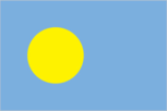
Flag Description
light blue with a large yellow disk shifted slightly to the hoist side; the blue color represents the ocean, the disk represents the moon; Palauans consider the full moon to be the optimum time for human activity; it is also considered a symbol of peace, love, and tranquility
Government Type
presidential republic in free association with the US
Independence
1 October 1994 (from the US-administered UN trusteeship)
International Law Organization Participation
has not submitted an ICJ jurisdiction declaration; non-party state to the ICCt
International Organization Participation
ACP, ADB, AOSIS, FAO, IAEA, IBRD, ICAO, ICRM, IDA, IFC, IFRCS, ILO, IMF, IMO, IMSO, IOC, IPU, MIGA, OPCW, PIF, Sparteca, SPC, UN, UNAMID, UNCTAD, UNESCO, WHO
Judicial Branch
- highest courts
- Supreme Court (consists of the chief justice and 3 associate justices organized into appellate trial divisions; the Supreme Court organization also includes the Common Pleas and Land Courts)
- judge selection and term of office
- justices nominated by a 7-member independent body consisting of judges, presidential appointees, and lawyers and appointed by the president; judges can serve until mandatory retirement at age 65
- subordinate courts
- National Court and other 'inferior' courts
Legal System
mixed legal system of civil, common, and customary law
Legislative Branch
- description
- bicameral National Congress or Olbiil Era Kelulau consists of:Senate (13 seats; members directly elected in single-seat constituencies by majority vote to serve 4-year terms) House of Delegates (16 seats; members directly elected in single-seat constituencies by simple majority vote to serve 4-year terms)
- election results
- Senate - percent of vote - NA; seats - independent 13; composition - men 11, women 2, percent of women 15.4% House of Delegates - percent of vote - NA; seats - independent 16; composition - men 14, women 2, percent of women 12.5%; note - total National Congress percent of women 13.8%
- elections
- Senate - last held on 1 November 2016 (next to be held in November 2020) House of Delegates - last held on 1 November 2016 (next to be held in November 2020)
National Anthem
- lyrics/music
- multiple/Ymesei O. EZEKIEL
- name
- "Belau rekid" (Our Palau)
- note
- adopted 1980
National Holiday
Constitution Day, 9 July (1981), day of a national referendum to pass the new constitutionIndependence Day, 1 October (1994)
National Symbol S
bai (native meeting house); national colors: blue, yellow
Political Parties And Leaders
none
Suffrage
18 years of age; universal
Economy
Agriculture Products
coconuts, cassava (manioc, tapioca), sweet potatoes; fish, pigs, chickens, eggs, bananas, papaya, breadfruit, calamansi, soursop, Polynesian chestnuts, Polynesian almonds, mangoes, taro, guava, beans, cucumbers, squash/pumpkins (various), eggplant, green onions, kangkong (watercress), cabbages (various), radishes, betel nuts, melons, peppers, noni, okra
Budget
- expenditures
- 167.3 million (2012 est.)
- revenues
- 193 million (2012 est.)
Budget Surplus Or Deficit
8.8% (of GDP) (2016 est.)
Current Account Balance
- -$53 million (2017 est.)
- -$36 million (2016 est.)
Debt External
- $18.38 billion (31 December 2014 est.)
- $16.47 billion (31 December 2013 est.)
Economy Overview
The economy is dominated by tourism, fishing, and subsistence agriculture. Government is a major employer of the work force relying on financial assistance from the US under the Compact of Free Association (Compact) with the US that took effect after the end of the UN trusteeship on 1 October 1994. The US provided Palau with roughly $700 million in aid for the first 15 years following commencement of the Compact in 1994 in return for unrestricted access to its land and waterways for strategic purposes. The population enjoys a per capita income roughly double that of the Philippines and much of Micronesia.Business and leisure tourist arrivals reached a record 167,966 in 2015, a 14.4% increase over the previous year, but fell to 138,408 in 2016. Long-run prospects for tourism have been bolstered by the expansion of air travel in the Pacific, the rising prosperity of industrial East Asia, and the willingness of foreigners to finance infrastructure development. Proximity to Guam, the region's major destination for tourists from East Asia, and a regionally competitive tourist infrastructure enhance Palau's advantage as a destination.
Exchange Rates
- note
- the US dollar is used
Exports
- $23.17 billion (2017 est.)
- $14.8 million (2015 est.)
Exports Commodities
shellfish, tuna, other fish (many species)
Exports Partners
Japan 51.3%, US 15.8%, India 13.8%, Guam 8% (2017)
Fiscal Year
1 October - 30 September
Gdp Composition By End Use
- exports of goods and services
- 55.2% (2016 est.)
- government consumption
- 27.2% (2016 est.)
- household consumption
- 60.5% (2016 est.)
- imports of goods and services
- -67.6% (2016 est.)
- investment in fixed capital
- 22.7% (2016 est.)
- investment in inventories
- 1.9% (2016 est.)
Gdp Composition By Sector Of Origin
- agriculture
- 3% (2016 est.)
- industry
- 19% (2016 est.)
- services
- 78% (2016 est.)
Gdp Official Exchange Rate
$292 million (2017 est.) (2017 est.)
Gdp Per Capita Ppp
- $14,700 (2017 est.)
- $15,200 (2016 est.)
- $15,200 (2015 est.)
- note
- data are in 2017 dollars
Gdp Purchasing Power Parity
- $264 million (2017 est.)
- $274.2 million (2016 est.)
- $274.1 million (2015 est.)
- note
- data are in 2017 dollars
Gdp Real Growth Rate
- -3.7% (2017 est.)
- 0% (2016 est.)
- 10.1% (2015 est.)
Gross National Saving
- 48.7% of GDP (2016 est.)
- 50.1% of GDP (2015 est.)
Household Income Or Consumption By Percentage Share
- highest 10%
- NA
- lowest 10%
- NA
Imports
- $4.715 billion (2018 est.)
- $4.079 billion (2017 est.)
Imports Commodities
machinery and equipment, fuels, metals; foodstuffs
Imports Partners
US 33.4%, Guam 15.8%, Japan 15.7%, China 13.5%, South Korea 5.3% (2017)
Industrial Production Growth Rate
NA
Industries
tourism, fishing, subsistence agriculture
Inflation Rate Consumer Prices
- 0.9% (2017 est.)
- -1% (2016 est.)
Labor Force
11,610 (2016)
Labor Force By Occupation
- agriculture
- 1.2%
- industry
- 12.4%
- services
- 86.4% (2016)
Market Value Of Publicly Traded Shares
- note
- NA
Population Below Poverty Line
24.9% NA (2006)
Public Debt
- 24.1% of GDP (2016 est.)
- 21.6% of GDP (2015)
Reserves Of Foreign Exchange And Gold
- $0 (31 December 2017 est.)
- $580.9 million (31 December 2015 est.)
Stock Of Direct Foreign Investment At Home
(31 December 2009 est.)
Taxes And Other Revenues
66.1% (of GDP) (2016 est.)
Unemployment Rate
- 1.7% (2015 est.)
- 4.1% (2012)
Energy
Electricity Access
- electrification - rural areas
- 45% (2012)
- electrification - total population
- 59% (2012)
- electrification - urban areas
- 62% (2012)
- population without electricity
- 8,752 (2012)
Communications
Broadcast Media
no broadcast TV stations; a cable TV network covers the major islands and provides access to 4 local cable stations, rebroadcasts (on a delayed basis) of a number of US stations, as well as access to a number of real-time satellite TV channels; about a half dozen radio stations (1 government-owned) (2017)
Internet Country Code
.pw
Internet Users
- percent of population
- 36% (July 2016 est.)
- total
- 7,650 (July 2016 est.)
Telephone System
- domestic
- fixed-line and mobile-cellular services available with a combined subscribership of over 140 per 100 persons (2016)
- general assessment
- well-developed mobile sector recently boosted by satellite network capacity upgrades (2016)
- international
- country code - 680; satellite earth station - 1 Intelsat (Pacific Ocean) (2016)
Telephones Fixed Lines
- subscriptions per 100 inhabitants
- 34 (July 2016 est.)
- total subscriptions
- 7,204 (July 2016 est.)
Telephones Mobile Cellular
- subscriptions per 100 inhabitants
- 112 (July 2016 est.)
- total subscriptions
- 24,000 (July 2016 est.)
Transportation
Airports
3 (2013)
Airports With Paved Runways
- 1,524 to 2,437 m
- 1 (2017)
- total
- 1 (2017)
Airports With Unpaved Runways
- 1,524 to 2,437 m
- 2 (2013)
- total
- 2 (2013)
National Air Transport System
- inventory of registered aircraft operated by air carriers
- 1 (2015)
- number of registered air carriers
- 1 (2015)
Ports And Terminals
- major seaport(s)
- Koror
Military and Security
Military Branches
no regular military forces; Palau National Police (2009)
Military Note
defense is the responsibility of the US; under a Compact of Free Association between Palau and the US, the US military is granted access to the islands for 50 years, but it has not stationed any military forces there (2008)
Transnational Issues
Disputes International
maritime delineation negotiations continue with Philippines, Indonesia