1996 Edition
CIA World Factbook 1996 (Project Gutenberg)
Introduction
Description
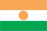
three equal horizontal bands of orange (top), white, and green with a small orange disk (representing the sun) centered in the white band; similar to the flag of India, which has a blue spoked wheel centered in the white band
Location
16 00 N, 8 00 E -- Western Africa, southeast of Algeria Flag ----
Geography
Area
- comparative area
- slightly less than twice the size of Texas
- land area
- 1,266,700 sq km
- total area
- 1.267 million sq km
Climate
desert; mostly hot, dry, dusty; tropical in extreme south
Coastline
0 km (landlocked)
Environment
- current issues
- overgrazing; soil erosion; deforestation; desertification; wildlife populations (such as elephant, hippopotamus, and lion) threatened because of poaching and habitat destruction
- international agreements
- party to - Biodiversity, Climate Change, Endangered Species, Environmental Modification, Nuclear Test Ban, Ozone Layer Protection, Wetlands; signed, but not ratified - Desertification, Law of the Sea
- natural hazards
- recurring droughts
Geographic coordinates
16 00 N, 8 00 E
Geographic note
landlocked
International disputes
Libya claims about 19,400 sq km in northern Niger; demarcation of international boundaries in Lake Chad, the lack of which has led to border incidents in the past, is completed and awaiting ratification by Cameroon, Chad, Niger, and Nigeria; Burkina Faso and Mali are proceeding with boundary demarcation, including the tripoint with Niger
Irrigated land
320 sq km (1989 est.)
Land boundaries
- border countries
- Algeria 956 km, Benin 266 km, Burkina Faso 628 km, Chad 1,175 km, Libya 354 km, Mali 821 km, Nigeria 1,497 km
- total
- 5,697 km
Land use
- arable land
- 3%
- forest and woodland
- 2%
- meadows and pastures
- 7%
- other
- 88%
- permanent crops
- 0%
Location
Western Africa, southeast of Algeria
Map references
Africa
Maritime claims
none (landlocked)
Natural resources
uranium, coal, iron ore, tin, phosphates
Terrain
- predominately desert plains and sand dunes; flat to rolling plains in south; hills in north
- highest point
- Mont Greboun 1,944 m
- lowest point
- Niger River 200 m
People and Society
Age structure
0-14 years: 48% (male 2,233,157; female 2,138,096) 15-64 years: 50% (male 2,202,413; female 2,317,188) 65 years and over: 2% (male 117,337; female 104,810) (July 1996 est.)
Birth rate
54.46 births/1,000 population (1996 est.)
Death rate
24.57 deaths/1,000 population (1996 est.)
Ethnic divisions
Hausa 56%, Djerma 22%, Fula 8.5%, Tuareg 8%, Beri Beri (Kanouri) 4.3%, Arab, Toubou, and Gourmantche 1.2%, about 4,000 French expatriates
Infant mortality rate
117.6 deaths/1,000 live births (1996 est.)
Languages
French (official), Hausa, Djerma
Life expectancy at birth
- female
- 40.25 years (1996 est.)
- male
- 41.05 years
- total population
- 40.66 years
Literacy
- age 15 and over can read and write (1995 est.)
- female
- 6.6%
- male
- 20.9%
- total population
- 13.6%
Nationality
- adjective
- Nigerien
- noun
- Nigerien(s)
Net migration rate
0 migrant(s)/1,000 population (1996 est.)
Population
9,113,001 (July 1996 est.)
Population growth rate
2.99% (1996 est.)
Religions
Muslim 80%, remainder indigenous beliefs and Christians
Sex ratio
- all ages
- 1 male(s)/female (1996 est.)
- at birth
- 1.03 male(s)/female
- under 15 years
- 1.04 male(s)/female 15-64 years: 0.95 male(s)/female 65 years and over: 1.12 male(s)/female
Total fertility rate
7.44 children born/woman (1996 est.)
Government
Administrative divisions
7 departments (departements, singular - departement), and 1 capital district* (capitale district); Agadez, Diffa, Dosso, Maradi, Niamey*, Tahoua, Tillaberi, Zinder
Capital
Niamey
Constitution
the constitution of January 1993 was revised by national referendum on 12 May 1996
Data code
NG
Diplomatic representation in US
- chancery
- 2204 R Street NW, Washington, DC 20008
- chief of mission
- Ambassador Adamou SEYDOU
- telephone
- [1] (202) 483-4224 through 4227
Executive branch
- cabinet
- National Salvation Council was appointed by President BARE
- chief of state
- President Colonel Ibrahim BARE Mainassara (since 28 January 1996 when he ousted President Mahamane OUSMANE in a coup); Mahamane OUSMANE had been elected for a five-year term by universal suffrage; election last held 17 March 1993 (next to be held 7 July 1996)
- head of government
- Prime Minister Boukary ADJI (since NA January 1996) appointed by President BARE
FAX
[227] 73 31 67
Flag
three equal horizontal bands of orange (top), white, and green with a small orange disk (representing the sun) centered in the white band; similar to the flag of India, which has a blue spoked wheel centered in the white band
Independence
3 August 1960 (from France)
International organization participation
ACCT, ACP, AfDB, CCC, ECA, ECOWAS, Entente, FAO, FZ, G-77, IAEA, IBRD, ICAO, ICRM, IDA, IDB, IFAD, IFC, IFRCS, ILO, IMF, Intelsat, Interpol, IOC, ITU, NAM, OAU, OIC, UN, UNAMIR, UNCTAD, UNESCO, UNIDO, UPU, WADB, WCL, WFTU, WHO, WIPO, WMO, WToO
Judicial branch
State Court (Cour d'Etat); Court of Appeal (Cour d'Apel)
Legal system
based on French civil law system and customary law; has not accepted compulsory ICJ jurisdiction
Legislative branch
unicameral
Name of country
- conventional long form
- Republic of Niger
- conventional short form
- Niger
- local long form
- Republique du Niger
- local short form
- Niger
National Assembly
elected by proportional representation for a five-year term; election last held 12 January 1995 (next to be held NA September 1996); results - percent of vote by party NA; seats - (83 total) MNSD-NASSARA 29, CDS 24, PNDS 12, ANDP-Z 9, UDFP 3, UDPS 2, PADN 2, PPN-RDA 1, UPDP 1; note - this National Assembly dissolved by President BARE after the coup on 28 January 1996
National holiday
Republic Day, 18 December (1958)
Political parties and leaders
National Movement of the Development Society (MNSD-NASSARA), Mamadou TANDJA, chairman; Democratic and Social Convention (CDS), Jacoub SANOUSSI; Nigerien Party for Democracy and Socialism (PNDS), Mahamadou ISSOUFOU; Nigerien Alliance for Democracy and Progress-Zamanlahia (ANDP-Z), Moumouni Adamou DJERMAKOYE; Union of Popular Forces for Democracy and Progress-Sawaba (UDFP), Djibo BAKARY, chairman; Union for Democracy and Social Progress (UDPS), Akoli DAOUEL; Niger Social Democrat Party (PADN), Malam Adji WAZIRI; Niger Progressive Party-African Democratic Rally (PPN-RDA), Dori ABDOULAI, chairman; Union of Patriots, Democrats, and Progressives (UPDP), Professor Andre SALIFOU, chairman
Suffrage
18 years of age; universal
Type of government
republic
US diplomatic representation
- chief of mission
- Ambassador John S. DAVISON
- embassy
- Rue Des Ambassades, Niamey
- mailing address
- B. P. 11201, Niamey
- telephone
- [227] 72 26 61 through 72 26 64
Economy
Agriculture
cowpeas, cotton, peanuts, millet, sorghum, cassava (tapioca), rice; cattle, sheep, goats
Budget
- expenditures
- $400 million, including capital expenditures of $125 million (1993 est.)
- revenues
- $188 million
Currency
1 Communaute Financiere Africaine franc (CFAF) = 100 centimes
Economic aid
- recipient
- ODA, $NA
Economic overview
Niger is one of the world's poorest countries, with recent GDP growth barely matching the rapid growth of population. The economy is centered on subsistence agriculture, animal husbandry, and reexport trade, and increasingly less on uranium, its major export throughout the 1970s and 1980s. Uranium revenues dropped by almost 50% between 1983 and 1990 with the end of the uranium boom. Terms of trade with Nigeria, Niger's largest regional trade partner, have improved dramatically since the 50% devaluation of the African franc in January 1994; this devaluation boosted exports of livestock, peas, onions, and the products of Niger's small cotton industry. The government relies on bilateral and multilateral aid for operating expenses and public investment and is strongly induced to adhere to structural adjustment programs designed by the IMF and the World Bank.
Electricity
- capacity
- 60,000 kW
- consumption per capita
- 42 kWh (1992)
- production
- 200 million kWh
Exchange rates
- CFA francs (CFAF) per US$1 - 500.56 (January 1996), 499.15 (1995), 555.20 (1994), 283.16 (1993), 264.69 (1992), 282.11 (1991)
- note
- beginning 12 January 1994, the CFA franc was devalued to CFAF 100 per French franc from CFAF 50 at which it had been fixed since 1948
Exports
- $232 million (f.o.b., 1994 est.)
- commodities
- uranium ore 67%, livestock products 20%, cowpeas, onions
- partners
- France 77%, Nigeria 8%, Cote d'Ivoire, Italy
External debt
$1.41 billion (1995 est.)
Fiscal year
1 October - 30 September
GDP
purchasing power parity - $5.5 billion (1995 est.)
GDP composition by sector
- agriculture
- 38.5%
- industry
- 17.9%
- services
- 43.6% (1993)
GDP per capita
$600 (1995 est.)
GDP real growth rate
6.7% (1995 est.)
Imports
- $234 million (c.i.f., 1994 est.)
- commodities
- consumer goods, primary materials, machinery, vehicles and parts, petroleum, cereals
- partners
- France 23%, Cote d'Ivoire, Germany, Italy, Japan
Industrial production growth rate
NA%
Industries
cement, brick, textiles, food processing, chemicals, slaughterhouses, and a few other small light industries; uranium mining
Inflation rate (consumer prices)
35.6% (1994 est.)
Labor force
- 2.5 million wage earners (1982)
- by occupation
- agriculture 90%, industry and commerce 6%, government 4%
Unemployment rate
NA%
Communications
Branches
Army, Air Force, National Gendarmerie, Republican Guard, National Police
Defense expenditures
exchange rate conversion - $32 million, 1.3% of GDP (FY92/93)
Manpower availability
- males age 15-49
- 1,920,244
- males fit for military service
- 1,035,218
- males reach military age (18) annually
- 92,132 (1996 est.)
Radio broadcast stations
AM 15, FM 5, shortwave 0
Radios
500,000 (1992 est.)
Telephone system
- small system of wire, radiotelephone communications, and microwave radio relay links concentrated in southwestern area
- domestic
- wire, radiotelephone communications, and microwave radio relay; domestic satellite system with 3 earth stations and 1 planned
- international
- satellite earth stations - 2 Intelsat (1 Atlantic Ocean and 1 Indian Ocean)
Telephones
14,000 (1991 est.)
Television broadcast stations
18
Televisions
38,000 (1992 est.) Defense
Transportation
Airports
- total
- 23
- with paved runways 1 524 to 2 437 m
- 6
- with paved runways 2 438 to 3 047 m
- 2
- with paved runways 914 to 1 523 m
- 1
- with paved runways under 914 m
- 2
- with unpaved runways 1 524 to 2 437 m
- 1
- with unpaved runways 914 to 1 523 m
- 11 (1995 est.)
Highways
- paved
- 3,265 km
- total
- 11,258 km
- unpaved
- 7,993 km (1990 est.)
Ports
none
Railways
0 km
Waterways
Niger river is navigable 300 km from Niamey to Gaya on the Benin frontier from mid-December through March