2011 Edition
CIA World Factbook 2011 Archive (HTML)
Introduction
Background
Equatorial Guinea gained independence in 1968 after 190 years of Spanish rule. This tiny country, composed of a mainland portion plus five inhabited islands, is one of the smallest on the African continent. President Teodoro OBIANG NGUEMA MBASOGO has ruled the country since 1979 when he seized power in a coup. Although nominally a constitutional democracy since 1991, the 1996, 2002, and 2009 presidential elections - as well as the 1999, 2004, and 2008 legislative elections - were widely seen as flawed. The president exerts almost total control over the political system and has discouraged political opposition. Equatorial Guinea has experienced rapid economic growth due to the discovery of large offshore oil reserves, and in the last decade has become Sub-Saharan Africa's third largest oil exporter. Despite the country's economic windfall from oil production resulting in a massive increase in government revenue in recent years, improvements in the population's living standards have been slow to develop.
Geography
Area
- 28,051 sq km 28,051 sq km 0 sq km
- total
- 28,051 sq km
- water
- 0 sq km
Area - comparative
slightly smaller than Maryland
Climate
tropical; always hot, humid
Coastline
296 km
Elevation extremes
- Atlantic Ocean 0 m Pico Basile 3,008 m
- highest point
- Pico Basile 3,008 m
- lowest point
- Atlantic Ocean 0 m
Environment - current issues
tap water is not potable; deforestation
Environment - international agreements
- Biodiversity, Climate Change, Climate Change-Kyoto Protocol, Desertification, Endangered Species, Hazardous Wastes, Law of the Sea, Marine Dumping, Ozone Layer Protection, Ship Pollution, Wetlands none of the selected agreements
- party to
- Biodiversity, Climate Change, Climate Change-Kyoto Protocol, Desertification, Endangered Species, Hazardous Wastes, Law of the Sea, Marine Dumping, Ozone Layer Protection, Ship Pollution, Wetlands
- signed, but not ratified
- none of the selected agreements
Freshwater withdrawal (domestic/industrial/agricultural)
- 0.11 cu km/yr (83%/16%/1%) 220 cu m/yr (2000)
- per capita
- 220 cu m/yr (2000)
- total
- 0.11 cu km/yr (83%/16%/1%)
Geographic coordinates
2 00 N, 10 00 E
Geography - note
insular and continental regions widely separated
Irrigated land
NA
Land boundaries
- 539 km Cameroon 189 km, Gabon 350 km
- border countries
- Cameroon 189 km, Gabon 350 km
- total
- 539 km
Land use
- 4.63% 3.57% 91.8% (2005)
- arable land
- 4.63%
- other
- 91.8% (2005)
- permanent crops
- 3.57%
Location
Western Africa, bordering the Bight of Biafra, between Cameroon and Gabon
Map references
Africa
Maritime claims
- 12 nm 200 nm
- exclusive economic zone
- 200 nm
- territorial sea
- 12 nm
Natural hazards
- violent windstorms; flash floods Santa Isabel (elev. 3,007 m), which last erupted in 1923, is the country's only historically active volcano; Santa Isabel, along with two dormant volcanoes, forms Bioko Island in the Gulf of Guinea
- volcanism
- Santa Isabel (elev. 3,007 m), which last erupted in 1923, is the country's only historically active volcano; Santa Isabel, along with two dormant volcanoes, forms Bioko Island in the Gulf of Guinea
Natural resources
petroleum, natural gas, timber, gold, bauxite, diamonds, tantalum, sand and gravel, clay
Terrain
coastal plains rise to interior hills; islands are volcanic
Total renewable water resources
26 cu km (2001)
People and Society
Age structure
- 41.5% (male 140,946/female 136,294) 54.4% (male 179,141/female 184,358) 4.1% (male 11,880/female 15,606) (2011 est.)
- 0-14 years
- 41.5% (male 140,946/female 136,294)
- 15-64 years
- 54.4% (male 179,141/female 184,358)
- 65 years and over
- 4.1% (male 11,880/female 15,606) (2011 est.)
Birth rate
35.43 births/1,000 population (2011 est.)
Children under the age of 5 years underweight
10.6% (2004)
Death rate
9.03 deaths/1,000 population (July 2011 est.)
Drinking water source
- urban: 45% of population rural: 42% of population total: 43% of population urban: 55% of population rural: 58% of population total: 57% of population (2000)
- rural
- 58% of population
- total
- 57% of population (2000)
- urban
- 55% of population
Education expenditures
0.6% of GDP (2003)
Ethnic groups
Fang 85.7%, Bubi 6.5%, Mdowe 3.6%, Annobon 1.6%, Bujeba 1.1%, other 1.4% (1994 census)
Health expenditures
2.2% of GDP (2009)
HIV/AIDS - adult prevalence rate
5% (2009 est.)
HIV/AIDS - deaths
fewer than 1,000 (2009 est.)
HIV/AIDS - people living with HIV/AIDS
20,000 (2009 est.)
Hospital bed density
1.92 beds/1,000 population (2009)
Infant mortality rate
- 77.3 deaths/1,000 live births 78.37 deaths/1,000 live births 76.19 deaths/1,000 live births (2011 est.)
- female
- 76.19 deaths/1,000 live births (2011 est.)
- total
- 77.3 deaths/1,000 live births
Languages
Spanish (official) 67.6%, other (includes French (official), Fang, Bubi) 32.4% (1994 census)
Life expectancy at birth
- 62.37 years 61.4 years 63.36 years (2011 est.)
- female
- 63.36 years (2011 est.)
- total population
- 62.37 years
Literacy
- age 15 and over can read and write 87% 93.4% 80.5% (2000 est.)
- definition
- age 15 and over can read and write
- female
- 80.5% (2000 est.)
- male
- 93.4%
- total population
- 87%
Major cities - population
MALABO (capital) 128,000 (2009)
Major infectious diseases
- very high bacterial and protozoal diarrhea, hepatitis A, and typhoid fever malaria and yellow fever rabies (2009)
- animal contact disease
- rabies (2009)
- degree of risk
- very high
- food or waterborne diseases
- bacterial and protozoal diarrhea, hepatitis A, and typhoid fever
- vectorborne disease
- malaria and yellow fever
Maternal mortality rate
280 deaths/100,000 live births (2008)
Median age
- 19.1 years 18.5 years 19.7 years (2011 est.)
- female
- 19.7 years (2011 est.)
- male
- 18.5 years
- total
- 19.1 years
Nationality
- Equatorial Guinean(s) or Equatoguinean(s) Equatorial Guinean or Equatoguinean
- adjective
- Equatorial Guinean or Equatoguinean
- noun
- Equatorial Guinean(s) or Equatoguinean(s)
Net migration rate
0 migrant(s)/1,000 population (2011 est.)
Physicians density
0.3 physicians/1,000 population (2004)
Population
668,225 (July 2011 est.)
Population growth rate
2.641% (2011 est.)
Religions
nominally Christian and predominantly Roman Catholic, pagan practices
School life expectancy (primary to tertiary education)
- 8 years 9 years 7 years (2002)
- female
- 7 years (2002)
- male
- 9 years
- total
- 8 years
Sex ratio
- 1.03 male(s)/female 1.03 male(s)/female 0.97 male(s)/female 0.78 male(s)/female 0.99 male(s)/female (2011 est.)
- 15-64 years
- 0.97 male(s)/female
- 65 years and over
- 0.78 male(s)/female
- at birth
- 1.03 male(s)/female
- total population
- 0.99 male(s)/female (2011 est.)
- under 15 years
- 1.03 male(s)/female
Total fertility rate
4.91 children born/woman (2011 est.)
Urbanization
- 40% of total population (2010) 3.1% annual rate of change (2010-15 est.)
- rate of urbanization
- 3.1% annual rate of change (2010-15 est.)
- urban population
- 40% of total population (2010)
Government
Administrative divisions
7 provinces (provincias, singular - provincia); Annobon, Bioko Norte, Bioko Sur, Centro Sur, Kie-Ntem, Litoral, Wele-Nzas
Capital
- Malabo 3 45 N, 8 47 E UTC+1 (6 hours ahead of Washington, DC during Standard Time)
- geographic coordinates
- 3 45 N, 8 47 E
- name
- Malabo
- time difference
- UTC+1 (6 hours ahead of Washington, DC during Standard Time)
Constitution
approved by national referendum 17 November 1991; amended January 1995
Country name
- Republic of Equatorial Guinea Equatorial Guinea Republica de Guinea Ecuatorial/Republique de Guinee equatoriale Guinea Ecuatorial/Guinee equatoriale Spanish Guinea
- conventional long form
- Republic of Equatorial Guinea
- conventional short form
- Equatorial Guinea
- former
- Spanish Guinea
- local long form
- Republica de Guinea Ecuatorial/Republique de Guinee equatoriale
- local short form
- Guinea Ecuatorial/Guinee equatoriale
Diplomatic representation from the US
- Ambassador Alberto M. FERNANDEZ KM-3, Carreterade de Aeropuerto (El Paraiso), Apartado 95, Malabo note - relocated embassy is opened for limited functions; inquiries should continue to be directed to the US Embassy in Yaounde, Cameroon B.P. 817, Yaounde, Cameroon; US Embassy Yaounde, US Department of State, Washington, DC 20521-2520 [237] 2220-1500 [237] 2220-1572
- chief of mission
- Ambassador Alberto M. FERNANDEZ
- embassy
- KM-3, Carreterade de Aeropuerto (El Paraiso), Apartado 95, Malabo note - relocated embassy is opened for limited functions; inquiries should continue to be directed to the US Embassy in Yaounde, Cameroon
- FAX
- [237] 2220-1572
- mailing address
- B.P. 817, Yaounde, Cameroon; US Embassy Yaounde, US Department of State, Washington, DC 20521-2520
- telephone
- [237] 2220-1500
Diplomatic representation in the US
- Ambassador Purificacion ANGUE ONDO 2020 16th Street NW, Washington, DC 20009 [1] (202) 518-5700 [1] (202) 518-5252
- chancery
- 2020 16th Street NW, Washington, DC 20009
- chief of mission
- Ambassador Purificacion ANGUE ONDO
- FAX
- [1] (202) 518-5252
- telephone
- [1] (202) 518-5700
Executive branch
- President Brig. Gen. (Ret.) Teodoro OBIANG NGUEMA MBASOGO (since 3 August 1979 when he seized power in a military coup) Prime Minister Ignacio MILAM Tang (since 8 July 2008) Council of Ministers appointed by the president president elected by popular vote for a seven-year term (no term limits); election last held on 29 November 2009 (next to be held in 2016); prime minister and deputy prime ministers appointed by the president Teodoro OBIANG NGUEMA MBASOGO reelected president; percent of vote - Teodoro OBIANG NGUEMA MBASOGO 95.8%, Placido Mico ABOGO 3.6%
- cabinet
- Council of Ministers appointed by the president
- chief of state
- President Brig. Gen. (Ret.) Teodoro OBIANG NGUEMA MBASOGO (since 3 August 1979 when he seized power in a military coup)
- election results
- Teodoro OBIANG NGUEMA MBASOGO reelected president; percent of vote - Teodoro OBIANG NGUEMA MBASOGO 95.8%, Placido Mico ABOGO 3.6%
- elections
- president elected by popular vote for a seven-year term (no term limits); election last held on 29 November 2009 (next to be held in 2016); prime minister and deputy prime ministers appointed by the president
- head of government
- Prime Minister Ignacio MILAM Tang (since 8 July 2008)
Flag description
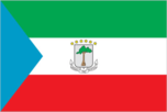
three equal horizontal bands of green (top), white, and red, with a blue isosceles triangle based on the hoist side and the coat of arms centered in the white band; the coat of arms has six yellow six-pointed stars (representing the mainland and five offshore islands) above a gray shield bearing a silk-cotton tree and below which is a scroll with the motto UNIDAD, PAZ, JUSTICIA (Unity, Peace, Justice); green symbolizes the jungle and natural resources, blue represents the sea that connects the mainland to the islands, white stands for peace, and red recalls the fight for independence
Government type
republic
Independence
12 October 1968 (from Spain)
International law organization participation
has not submitted an ICJ jurisdiction declaration; non-party state to the ICCt
International organization participation
ACP, AfDB, AU, BDEAC, CEMAC, CPLP (associate), FAO, FZ, G-77, IBRD, ICAO, ICRM, IDA, IFAD, IFC, IFRCS, ILO, IMF, IMO, Interpol, IOC, ITSO, ITU, MIGA, NAM, OAS (observer), OIF, OPCW, UN, UNCTAD, UNESCO, UNIDO, UNWTO, UPU, WHO, WIPO, WTO (observer)
Judicial branch
Supreme Tribunal
Legal system
mixed system of civil and customary law
Legislative branch
- unicameral House of People's Representatives or Camara de Representantes del Pueblo (100 seats; members directly elected by popular vote to serve five-year terms) last held on 4 May 2008 (next to be held in 2012) percent of vote by party - NA; seats by party - PDGE 89, EC 10, CPDS 1 Parliament has little power since the constitution vests all executive authority in the president
- election results
- percent of vote by party - NA; seats by party - PDGE 89, EC 10, CPDS 1
- elections
- last held on 4 May 2008 (next to be held in 2012)
National anthem
- "Caminemos pisando la senda" (Let Us Tread the Path) Atanasio Ndongo MIYONO/Atanasio Ndongo MIYONO or Ramiro Sanchez LOPEZ (disputed) adopted 1968
- lyrics/music
- Atanasio Ndongo MIYONO/Atanasio Ndongo MIYONO or Ramiro Sanchez LOPEZ (disputed)
- name
- "Caminemos pisando la senda" (Let Us Tread the Path)
National holiday
Independence Day, 12 October (1968)
National symbol(s)
silk cotton tree
Political parties and leaders
Convergence Party for Social Democracy or CPDS [Placido MICO Abogo]; Democratic Party for Equatorial Guinea or PDGE [Teodoro OBIANG NGUEMA MBASOGO] (ruling party); Electoral Coalition or EC; Party for Progress of Equatorial Guinea or PPGE [Severo MOTO]; Popular Action of Equatorial Guinea or APGE [Avelino MOCACHE]; Popular Union or UP [Daniel MARTINEZ Ayecaba]
Political pressure groups and leaders
ASODEGUE (Madrid-based pressure group for democratic reform); EG Justice (US-based anti-corruption group)
Suffrage
18 years of age; universal
Economy
Agriculture - products
coffee, cocoa, rice, yams, cassava (tapioca), bananas, palm oil nuts; livestock; timber
Budget
- $6.598 billion $6.851 billion (2010 est.)
- expenditures
- $6.851 billion (2010 est.)
- revenues
- $6.598 billion
Budget surplus (+) or deficit (-)
-1.7% of GDP (2010 est.)
Central bank discount rate
8.5% (31 December 2010 est.) 4.25% (31 December 2009 est.)
Commercial bank prime lending rate
15% (31 December 2010 est.) 15% (31 December 2009 est.)
Current account balance
-$1.302 billion (2010 est.) -$1.95 billion (2009 est.)
Debt - external
$794.7 million (31 December 2010 est.) $757.2 million (31 December 2009 est.)
Economy - overview
The discovery and exploitation of large oil and gas reserves have contributed to dramatic economic growth but fluctuating oil prices have produced huge swings in GDP growth in recent years. Forestry and farming are also minor components of GDP. Subsistence farming is the dominate form of livelihood. Although pre-independence Equatorial Guinea counted on cocoa production for hard currency earnings, the neglect of the rural economy under successive regimes has diminished potential for agriculture-led growth (the government has stated its intention to reinvest some oil revenue into agriculture). A number of aid programs sponsored by the World Bank and the IMF have been cut off since 1993 because of corruption and mismanagement. The government has been widely criticized for its lack of transparency and misuse of oil revenues; however, in 2010, under Equatorial Guinea's candidacy in the Extractive Industries Transparency Initiative, the government published oil revenue figures for the first time. Undeveloped natural resources include gold, zinc, diamonds, columbite-tantalite, and other base metals. Growth remained strong in 2008, when oil production peaked, but slowed in 2009-10, as the price of oil and the production level fell.
Electricity - consumption
85.56 million kWh (2008 est.)
Electricity - exports
0 kWh (2009 est.)
Electricity - imports
0 kWh (2009 est.)
Electricity - production
92 million kWh (2008 est.)
Exchange rates
Cooperation Financiere en Afrique Centrale francs per US dollar - 495.28 (2010) 472.19 (2009) 447.81 (2008) 481.83 (2007) 522.4 (2006)
Exports
$10.39 billion (2010 est.) $8.495 billion (2009 est.)
Exports - commodities
petroleum products, timber
Exports - partners
US 24.3%, Italy 10.3%, Spain 10.1%, South Korea 8.3%, Canada 7.6%, China 6.3%, Netherlands 6.1%, Brazil 5.9% (2010)
GDP - composition by sector
- 2.2% 93.9% 3.8% (2010 est.)
- agriculture
- 2.2%
- industry
- 93.9%
- services
- 3.8% (2010 est.)
GDP - per capita (PPP)
$36,600 (2010 est.) $37,900 (2009 est.) $36,800 (2008 est.) data are in 2010 US dollars; population figures are uncertain for Equatorial Guinea; these per capita income figures are based on a estimated population of less than 700,000; some estimates put the figure as high as 1.2 million people; if true, the per capita GDP figures would be significantly lower
GDP - real growth rate
-0.8% (2010 est.) 5.7% (2009 est.) 10.7% (2008 est.)
GDP (official exchange rate)
$14.49 billion (2010 est.)
GDP (purchasing power parity)
$23.82 billion (2010 est.) $24.02 billion (2009 est.) $22.71 billion (2008 est.) data are in 2010 US dollars
Household income or consumption by percentage share
- NA% NA%
- highest 10%
- NA%
- lowest 10%
- NA%
Imports
$5.7 billion (2010 est.) $5.258 billion (2009 est.)
Imports - commodities
petroleum sector equipment, other equipment, construction materials, vehicles
Imports - partners
China 21.4%, Spain 13.8%, US 12.7%, France 10.9%, Cote dIvoire 6.7%, UK 6.3%, Italy 5.2% (2010)
Industrial production growth rate
1.8% (2010 est.)
Industries
petroleum, natural gas, sawmilling
Inflation rate (consumer prices)
8.2% (2010 est.) 7.1% (2009 est.)
Investment (gross fixed)
35.2% of GDP (2010 est.)
Labor force
195,200 (2007)
Natural gas - consumption
1.55 billion cu m (2009 est.)
Natural gas - exports
4.72 billion cu m (2009 est.)
Natural gas - imports
0 cu m (2009 est.)
Natural gas - production
6.27 billion cu m (2009 est.)
Natural gas - proved reserves
36.81 billion cu m (1 January 2011 est.)
Oil - consumption
2,000 bbl/day (2010 est.)
Oil - exports
395,000 bbl/day (2009 est.)
Oil - imports
1,729 bbl/day (2009 est.)
Oil - production
322,700 bbl/day (2010 est.)
Oil - proved reserves
1.1 billion bbl (1 January 2011 est.)
Population below poverty line
NA%
Public debt
5.1% of GDP (2010 est.) 5.4% of GDP (2009 est.)
Reserves of foreign exchange and gold
$2.346 billion (31 December 2010 est.) $3.252 billion (31 December 2009 est.)
Stock of broad money
$2.109 billion (31 December 2010 est.) $1.527 billion (31 December 2009 est.)
Stock of domestic credit
$171.8 million (31 December 2010 est.) $1.534 billion (31 December 2009 est.)
Stock of narrow money
$1.889 billion (31 December 2010 est.) $1.342 billion (31 December 2009 est.)
Taxes and other revenues
45.6% of GDP (2010 est.)
Unemployment rate
22.3% (2009 est.)
Communications
Broadcast media
state maintains control of broadcast media with domestic broadcast media limited to 1 state-owned TV station, 1 state-owned radio station, and 1 private radio station owned by the president's eldest son; satellite TV service is available; transmissions of multiple international broadcasters are accessible (2007)
Internet country code
.gq
Internet hosts
9 (2010)
Internet users
14,400 (2009)
Telephone system
- digital fixed-line network in most major urban areas and good mobile coverage fixed-line density is about 2 per 100 persons; mobile-cellular subscribership has been increasing and in 2009 stood at about 70 percent of the population country code - 240; international communications from Bata and Malabo to African and European countries; satellite earth station - 1 Intelsat (Indian Ocean) (2009)
- domestic
- fixed-line density is about 2 per 100 persons; mobile-cellular subscribership has been increasing and in 2009 stood at about 70 percent of the population
- general assessment
- digital fixed-line network in most major urban areas and good mobile coverage
- international
- country code - 240; international communications from Bata and Malabo to African and European countries; satellite earth station - 1 Intelsat (Indian Ocean) (2009)
Telephones - main lines in use
13,500 (2010)
Telephones - mobile cellular
399,300 (2010)
Transportation
Airports
7 (2010)
Airports - with paved runways
- 2 (2010)
- 1,524 to 2,437 m
- 1
- 2,438 to 3,047 m
- 2
- 914 to 1,523 m
- 1
- total
- 6
- under 914 m
- 2 (2010)
Airports - with unpaved runways
- 1 (2010)
- 2,438 to 3,047 m
- 1 (2010)
- total
- 1
Merchant marine
- cargo 1, chemical tanker 1, petroleum tanker 2 1 (Norway 1) (2010)
- foreign-owned
- 1 (Norway 1) (2010)
- total
- 4
Pipelines
gas 37 km (2010)
Ports and terminals
Bata, Luba, Malabo (2010)
Roadways
- 2,880 km (2000)
- total
- 2,880 km (2000)
Military and Security
Manpower available for military service
- 151,147 150,345 (2010 est.)
- females age 16-49
- 150,345 (2010 est.)
- males age 16-49
- 151,147
Manpower fit for military service
- 113,277 115,320 (2010 est.)
- females age 16-49
- 115,320 (2010 est.)
- males age 16-49
- 113,277
Manpower reaching militarily significant age annually
- 7,398 7,126 (2010 est.)
- female
- 7,126 (2010 est.)
- male
- 7,398
Military branches
National Guard (Guardia Nacional de Guinea Ecuatoria, GNGE (Army), with Coast Guard (Navy) and Air Wing) (2011)
Military expenditures
0.1% of GDP (2009)
Military service age and obligation
18 years of age for selective compulsory military service; service obligation 2 years; women hold only administrative positions in the Coast Guard (2011)
Transnational Issues
Disputes - international
in 2002, ICJ ruled on an equidistance settlement of Cameroon-Equatorial Guinea-Nigeria maritime boundary in the Gulf of Guinea, but a dispute between Equatorial Guinea and Cameroon over an island at the mouth of the Ntem River and imprecisely defined maritime coordinates in the ICJ decision delay final delimitation; UN urges Equatorial Guinea and Gabon to resolve the sovereignty dispute over Gabon-occupied Mbane and lesser islands and to create a maritime boundary in the hydrocarbon-rich Corisco Bay
Trafficking in persons
- Equatorial Guinea is primarily a destination country for children trafficked for the purpose of forced labor and possibly for the purpose of sexual exploitation; children have been trafficked from nearby countries for domestic servitude, market labor, ambulant vending, and possibly sexual exploitation; women may also be trafficked to Equatorial Guinea from Cameroon, Benin, other neighboring countries, and China for sexual exploitation Tier 3 - Equatorial Guinea is not making significant efforts to comply with the minimum standards on the elimination of trafficking; despite limited law enforcement action against suspected human smugglers and traffickers, including complicit public officials, the government has made no tangible efforts to provide victims of trafficking with the protective services mandated in its 2004 anti-trafficking law; prevention efforts have decreased, as the government did not hold any public awareness campaigns and its interagency commission on human trafficking took little, if any, action; the government's response to human trafficking has been inadequate, particularly given the government's substantial financial resources (2011)
- current situation
- Equatorial Guinea is primarily a destination country for children trafficked for the purpose of forced labor and possibly for the purpose of sexual exploitation; children have been trafficked from nearby countries for domestic servitude, market labor, ambulant vending, and possibly sexual exploitation; women may also be trafficked to Equatorial Guinea from Cameroon, Benin, other neighboring countries, and China for sexual exploitation
- tier rating
- Tier 3 - Equatorial Guinea is not making significant efforts to comply with the minimum standards on the elimination of trafficking; despite limited law enforcement action against suspected human smugglers and traffickers, including complicit public officials, the government has made no tangible efforts to provide victims of trafficking with the protective services mandated in its 2004 anti-trafficking law; prevention efforts have decreased, as the government did not hold any public awareness campaigns and its interagency commission on human trafficking took little, if any, action; the government's response to human trafficking has been inadequate, particularly given the government's substantial financial resources (2011)