2022 Edition
CIA World Factbook 2022 (factbook.json @ 61dadec0c9c9)
Introduction
Background
Polynesians from Tahiti were probably the first people to settle Rarotonga around A.D. 900. Over time, Samoans and Tongans also settled in Rarotonga, and Rarotongans voyaged to the northern Cook Islands, settling Manihiki and Rakahanga. Pukapuka and Penrhyn in the northern Cook Islands were settled directly from Samoa. Prior to European contact, there was considerable travel and trade between inhabitants of the different islands and atolls but they were not united in a single political entity. Spanish navigators were the first Europeans to spot the northern Cook Islands in 1595 followed by the first landing in 1606. The Cook Islands remained free of further European contact until the 1760s, and in 1773, British explorer James COOK saw Manuae in the southern Cook Islands. The islands were named after COOK in the 1820s by Russian mapmakers. English missionary activity during the 1820s and 1830s banned singing and dancing and converted most of the population.Fearing France would militarily occupy the islands like it did in Tahiti, Rarotongans asked the UK for protectorate status in the 1840s and 1860s, which the UK ignored. In 1888, Queen MAKEA TAKAU of Rarotonga formally petitioned for protectorate status, which the UK reluctantly agreed to. In 1901, the UK placed Rarotonga and the rest of the islands in the New Zealand Colony and in 1915, the Cook Islands Act organized the Cook Islands into one political entity. It remained a protectorate until 1965, when New Zealand granted the Cook Islands self-government status. The Cook Islands has a great deal of local autonomy and is an independent member of international organizations, but it is in free association with New Zealand, which is responsible for defense and foreign affairs. Economic opportunities in the Cook Islands are sparse, and more Cook Islanders live in New Zealand than in the Cook Islands.In a referendum in 1994, voters chose to keep the name Cook Islands rather than changing to a Maori name for the islands. The issue was revived in 2019, but after being poorly received by the diaspora in New Zealand, the government decided to retain the name Cook Islands but to provide a Maori name alongside it. The Maori name has not yet been determined.
Geography
Area
- land
- 236 sq km
- total
- 236 sq km
- water
- 0 sq km
Area - comparative
1.3 times the size of Washington, DC
Climate
tropical oceanic; moderated by trade winds; a dry season from April to November and a more humid season from December to March
Coastline
120 km
Elevation
- highest point
- Te Manga 652 m
- lowest point
- Pacific Ocean 0 m
Geographic coordinates
21 14 S, 159 46 W
Geography - note
the northern Cook Islands are seven low-lying, sparsely populated, coral atolls; the southern Cook Islands, where most of the population lives, consist of eight elevated, fertile, volcanic isles, including the largest, Rarotonga, at 67 sq km
Irrigated land
NA
Land boundaries
- total
- 0 km
Land use
- agricultural land
- 8.4% (2018 est.)
- agricultural land: arable land
- arable land: 4.2% (2018 est.)
- agricultural land: permanent crops
- permanent crops: 4.2% (2018 est.)
- agricultural land: permanent pasture
- permanent pasture: 0% (2018 est.)
- forest
- 64.6% (2018 est.)
- other
- 27% (2018 est.)
Location
Oceania, group of islands in the South Pacific Ocean, about halfway between Hawaii and New Zealand
Map references
Oceania
Maritime claims
- continental shelf
- 200 nm or to the edge of the continental margin
- exclusive economic zone
- 200 nm
- territorial sea
- 12 nm
Natural hazards
tropical cyclones (November to March)
Natural resources
coconuts (copra)
Population distribution
most of the population is found on the island of Rarotonga
Terrain
low coral atolls in north; volcanic, hilly islands in south
People and Society
Age structure
- 0-14 years
- 18.69% (male 797/female 722)
- 15-24 years
- 13.9% (male 606/female 524)
- 25-54 years
- 37.66% (male 1,595/female 1,634)
- 55-64 years
- 15.69% (male 711/female 564)
- 65 years and over
- 14.74% (male 584/female 614) (2022 est.)
Alcohol consumption per capita
- beer
- 3.62 liters of pure alcohol (2019 est.)
- other alcohols
- 0 liters of pure alcohol (2019 est.)
- spirits
- 7.07 liters of pure alcohol (2019 est.)
- total
- 12.97 liters of pure alcohol (2019 est.)
- wine
- 2.28 liters of pure alcohol (2019 est.)
Birth rate
12.55 births/1,000 population (2022 est.)
Children under the age of 5 years underweight
NA
Contraceptive prevalence rate
NA
Current health expenditure
3.1% of GDP (2019)
Death rate
9.1 deaths/1,000 population (2022 est.)
Dependency ratios
- elderly dependency ratio
- 17.4
- potential support ratio
- 5.8 (2021)
- total dependency ratio
- 53.8
- youth dependency ratio
- 36.4
Drinking water source
- improved: rural
- rural: NA
- improved: total
- total: 100% of population
- improved: urban
- urban: NA
- unimproved: rural
- rural: NA
- unimproved: total
- total: 0% of population (2020 est.)
- unimproved: urban
- urban: NA
Education expenditures
4.6% of GDP (2021 est.)
Ethnic groups
Cook Island Maori (Polynesian) 81.3%, part Cook Island Maori 6.7%, other 11.9% (2011 est.)
HIV/AIDS - adult prevalence rate
NA
Infant mortality rate
- female
- 11.62 deaths/1,000 live births (2022 est.)
- male
- 20.02 deaths/1,000 live births
- total
- 15.93 deaths/1,000 live births
Languages
- English (official) 86.4%, Cook Islands Maori (Rarotongan) (official) 76.2%, other 8.3% (2011 est.)
- note
- note: shares sum to more than 100% because some respondents gave more than one answer on the census
Life expectancy at birth
- female
- 80.11 years (2022 est.)
- male
- 74.32 years
- total population
- 77.14 years
Literacy
- female
- NA
- male
- NA
- total population
- NA
Major infectious diseases
- degree of risk
- high (2020)
- food or waterborne diseases
- bacterial diarrhea
- vectorborne diseases
- malaria
Median age
- female
- 38.7 years (2020 est.)
- male
- 37.8 years
- total
- 38.3 years
Nationality
- adjective
- Cook Islander
- noun
- Cook Islander(s)
Net migration rate
-27.31 migrant(s)/1,000 population (2022 est.)
Obesity - adult prevalence rate
55.9% (2016)
Physicians density
1.41 physicians/1,000 population (2014)
Population
- 8,128 (2022 est.)
- note
- note: the Cook Islands' Ministry of Finance & Economic Management estimated the resident population to have been 11,700 in September 2016
Population distribution
most of the population is found on the island of Rarotonga
Population growth rate
-2.39% (2022 est.)
Religions
Protestant 62.8% (Cook Islands Christian Church 49.1%, Seventh Day Adventist 7.9%, Assemblies of God 3.7%, Apostolic Church 2.1%), Roman Catholic 17%, Church of Jesus Christ 4.4%, other 8%, none 5.6%, no response 2.2% (2011 est.)
Sanitation facility access
- improved: rural
- rural: NA
- improved: total
- total: 99.1% of population
- improved: urban
- urban: NA
- unimproved: rural
- rural: NA
- unimproved: total
- total: 0.9% of population (2020 est.)
- unimproved: urban
- urban: NA
School life expectancy (primary to tertiary education)
- female
- 14 years (2012)
- male
- 15 years
- total
- 15 years
Sex ratio
- 0-14 years
- 1.1 male(s)/female
- 15-24 years
- 1.16 male(s)/female
- 25-54 years
- 0.96 male(s)/female
- 55-64 years
- 1.26 male(s)/female
- 65 years and over
- 0.73 male(s)/female
- at birth
- 1.04 male(s)/female
- total population
- 1.06 male(s)/female (2022 est.)
Tobacco use
- female
- 20.3% (2020 est.)
- male
- 27.7% (2020 est.)
- total
- 24% (2020 est.)
Total fertility rate
2.07 children born/woman (2022 est.)
Urbanization
- rate of urbanization
- 0.52% annual rate of change (2020-25 est.)
- urban population
- 76.2% of total population (2023)
Government
Administrative divisions
none
Capital
- etymology
- translates as "two harbors" in Maori
- geographic coordinates
- 21 12 S, 159 46 W
- name
- Avarua
- time difference
- UTC-10 (5 hours behind Washington, DC, during Standard Time)
Constitution
- amendments
- proposed by Parliament; passage requires at least two-thirds majority vote by the Parliament membership in each of several readings and assent of the chief of state’s representative; passage of amendments relating to the chief of state also requires two-thirds majority approval in a referendum; amended many times, last in 2004
- history
- 4 August 1965 (Cook Islands Constitution Act 1964)
Country name
- conventional long form
- none
- conventional short form
- Cook Islands
- etymology
- named after Captain James COOK, the British explorer who visited the islands in 1773 and 1777
- former
- Hervey Islands
Dependency status
self-governing in free association with New Zealand; Cook Islands is fully responsible for internal affairs; New Zealand retains responsibility for external affairs and defense in consultation with the Cook Islands
Diplomatic representation from the US
- embassy
- none (self-governing in free association with New Zealand)
Diplomatic representation in the US
none (self-governing in free association with New Zealand)
Executive branch
- cabinet
- Cabinet chosen by the prime minister
- chief of state
- King CHARLES III (since 8 September 2022); represented by Sir Tom J. MARSTERS (since 9 August 2013); New Zealand High Commissioner Ms Tui DEWES (since October 2020)
- elections/appointments
- the monarchy is hereditary; UK representative appointed by the monarch; New Zealand high commissioner appointed by the New Zealand Government; following legislative elections, the leader of the majority party or majority coalition usually becomes prime minister
- head of government
- Prime Minister Mark BROWN (since 1 October 2020)
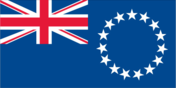
Flag description
blue with the flag of the UK in the upper hoist-side quadrant and a large circle of 15 white five-pointed stars (one for every island) centered in the outer half of the flag
Government type
parliamentary democracy
Independence
none (became self-governing in free association with New Zealand on 4 August 1965 with the right at any time to move to full independence by unilateral action)
International law organization participation
has not submitted an ICJ jurisdiction declaration (New Zealand normally retains responsibility for external affairs); accepts ICCt jurisdiction
International organization participation
ACP, ADB, AOSIS, FAO, ICAO, ICCt, ICRM, IFAD, IFRCS, IMO, IMSO, IOC, ITUC (NGOs), OPCW, PIF, Sparteca, SPC, UNESCO, UPU, WHO, WMO
Judicial branch
- highest court(s)
- Court of Appeal (consists of the chief justice and 3 judges of the High Court); High Court (consists of the chief justice and at least 4 judges and organized into civil, criminal, and land divisions); note - appeals beyond the Cook Islands Court of Appeal are heard by the Judicial Committee of the Privy Council (in London)
- judge selection and term of office
- High Court chief justice appointed by the Queen's Representative on the advice of the Executive Council tendered by the prime minister; other judges appointed by the Queen's Representative, on the advice of the Executive Council tendered by the chief justice, High Court chief justice, and the minister of justice; chief justice and judges appointed for 3-year renewable terms
- subordinate courts
- justices of the peace
Legal system
common law similar to New Zealand common law
Legislative branch
- description
- unicameral Parliament, formerly the Legislative Assembly (24 seats; members directly elected in single-seat constituencies by simple majority vote to serve 4-year terms); note - the House of Ariki, a 24-member parliamentary body of traditional leaders appointed by the Queen's representative serves as a consultative body to the Parliament
- election results
- percent of vote by party - NA; seats by party - Demo 11, CIP 10, One Cook Islands Movement 1, independent 2; composition - men 17, women 7, percent of women 17.7%
- elections
- last held on 14 June 2018 (next to be held by 2022)
National anthem
- lyrics/music
- Tepaeru Te RITO/Thomas DAVIS
- name
- "Te Atua Mou E" (To God Almighty)
- note
- note: adopted 1982; as prime minister, Sir Thomas DAVIS composed the anthem; his wife, a tribal chief, wrote the lyrics
National holiday
Constitution Day, the first Monday in August (1965)
National symbol(s)
a circle of 15, five-pointed, white stars on a blue field, Tiare maori (Gardenia taitensis) flower; national colors: green, white
Political parties and leaders
Cook Islands Party or CIP [Mark BROWN]Democratic Party or Demo [Tina BROWNE]One Cook Islands Movement [Teina BISHOP]
Suffrage
18 years of age; universal
Economy
Agricultural products
vegetables, coconuts, roots/tubers, cassava, papayas, tomatoes, pork, fruit, sweet potatoes, mangoes/guavas
Budget
- expenditures
- 77.9 million (2010)
- revenues
- 86.9 million (2010)
Budget surplus (+) or deficit (-)
3% (of GDP) (2010 est.)
Current account balance
- Current account balance 2005
- $26.67 million (2005)
Debt - external
- Debt - external 1996
- $141 million (1996 est.)
Economic overview
Like many other South Pacific island nations, the Cook Islands' economic development is hindered by the isolation of the country from foreign markets, the limited size of domestic markets, lack of natural resources, periodic devastation from natural disasters, and inadequate infrastructure. Agriculture, employing more than one-quarter of the working population, provides the economic base with major exports of copra and citrus fruit. Black pearls are the Cook Islands' leading export. Manufacturing activities are limited to fruit processing, clothing, and handicrafts. Trade deficits are offset by remittances from emigrants and by foreign aid overwhelmingly from New Zealand. In the 1980s and 1990s, the country became overextended, maintaining a bloated public service and accumulating a large foreign debt. Subsequent reforms, including the sale of state assets, the strengthening of economic management, the encouragement of tourism, and a debt restructuring agreement, have rekindled investment and growth. The government is targeting fisheries and seabed mining as sectors for future economic growth.
Exchange rates
- Currency
- NZ dollars (NZD) per US dollar -
- Exchange rates 2013
- 1.4279 (2013 est.)
- Exchange rates 2014
- 1.441 (2014 est.)
- Exchange rates 2015
- 1.4341 (2015 est.)
- Exchange rates 2016
- 1.4341 (2016 est.)
- Exchange rates 2017
- 1.416 (2017 est.)
Exports
- Exports 2010
- $5.163 million (2010 est.)
- Exports 2011
- $3.125 million (2011 est.)
- note
- note: Data are in current year dollars and do not include illicit exports or re-exports.
Exports - commodities
fish products, recreational boats, precious metal scraps, fruit juice, chemical analysis instruments (2019)
Exports - partners
Japan 37%, Thailand 21%, France 17% (2019)
Fiscal year
1 April - 31 March
GDP - composition, by sector of origin
- agriculture
- 5.1% (2010 est.)
- industry
- 12.7% (2010 est.)
- services
- 82.1% (2010 est.)
GDP (official exchange rate)
$299.9 million (2016 est.)
Household income or consumption by percentage share
- highest 10%
- NA
- lowest 10%
- NA
Imports
- Imports 2010
- $90.62 million (2010 est.)
- Imports 2011
- $109.3 million (2011 est.)
Imports - commodities
ships, refined petroleum, recreational boats, cars, flavored water (2019)
Imports - partners
New Zealand 41%, China 21%, Italy 12%, Fiji 10% (2019)
Industrial production growth rate
1% (2002)
Industries
fishing, fruit processing, tourism, clothing, handicrafts
Inflation rate (consumer prices)
- Inflation rate (consumer prices) 2011
- 2.2% (2011 est.)
Labor force
6,820 (2001)
Labor force - by occupation
- agriculture
- 29%
- industry
- 15%
- services
- 56% (1995)
Population below poverty line
NA
Real GDP (purchasing power parity)
- Real GDP (purchasing power parity) 2015
- $183.2 million (2015 est.)
- Real GDP (purchasing power parity) 2016
- $299.9 million (2016 est.)
Real GDP growth rate
- Real GDP growth rate 2005
- 0.1% (2005 est.)
Real GDP per capita
- Real GDP per capita 2005
- $9,100 (2005 est.)
- Real GDP per capita 2016
- $16,700 (2016 est.)
Taxes and other revenues
29% (of GDP) (2010 est.)
Unemployment rate
- Unemployment rate 2005
- 13.1% (2005)
Energy
Carbon dioxide emissions
- from coal and metallurgical coke
- 0 metric tonnes of CO2 (2019 est.)
- from consumed natural gas
- 0 metric tonnes of CO2 (2019 est.)
- from petroleum and other liquids
- 114,000 metric tonnes of CO2 (2019 est.)
- total emissions
- 114,000 metric tonnes of CO2 (2019 est.)
Coal
- consumption
- 0 metric tons (2020 est.)
- exports
- 0 metric tons (2020 est.)
- imports
- 0 metric tons (2020 est.)
- production
- 0 metric tons (2020 est.)
- proven reserves
- 0 metric tons (2019 est.)
Electricity
- consumption
- 38.729 million kWh (2019 est.)
- exports
- 0 kWh (2020 est.)
- imports
- 0 kWh (2020 est.)
- installed generating capacity
- 18,000 kW (2020 est.)
- transmission/distribution losses
- 3 million kWh (2019 est.)
Electricity generation sources
- biomass and waste
- 0% of total installed capacity (2020 est.)
- fossil fuels
- 70% of total installed capacity (2020 est.)
- geothermal
- 0% of total installed capacity (2020 est.)
- hydroelectricity
- 0% of total installed capacity (2020 est.)
- nuclear
- 0% of total installed capacity (2020 est.)
- solar
- 30% of total installed capacity (2020 est.)
- tide and wave
- 0% of total installed capacity (2020 est.)
- wind
- 0% of total installed capacity (2020 est.)
Energy consumption per capita
- Total energy consumption per capita 2019
- 0 Btu/person (2019 est.)
Natural gas
- consumption
- 0 cubic meters (2021 est.)
- exports
- 0 cubic meters (2021 est.)
- imports
- 0 cubic meters (2021 est.)
- production
- 0 cubic meters (2021 est.)
- proven reserves
- 0 cubic meters (2021 est.)
Petroleum
- crude oil and lease condensate exports
- 0 bbl/day (2018 est.)
- crude oil and lease condensate imports
- 0 bbl/day (2018 est.)
- crude oil estimated reserves
- 0 barrels (2021 est.)
- refined petroleum consumption
- 800 bbl/day (2019 est.)
- total petroleum production
- 0 bbl/day (2021 est.)
Refined petroleum products - exports
0 bbl/day (2015 est.)
Refined petroleum products - imports
611 bbl/day (2015 est.)
Refined petroleum products - production
0 bbl/day (2015 est.)
Communications
Broadband - fixed subscriptions
- subscriptions per 100 inhabitants
- 15 (2018 est.)
- total
- 2,700 (2018 est.)
Broadcast media
1 privately owned TV station broadcasts from Rarotonga providing a mix of local news and overseas-sourced programs (2019)
Internet country code
.ck
Internet users
- percent of population
- 54% (2019 est.)
- total
- 9,476 (2019 est.)
Telecommunication systems
- domestic
- service is provided by small exchanges connected to subscribers by open-wire, cable, and fiber-optic cable; nearly 38 per 100 fixed-line and about 83 per 100 mobile-cellular (2019)
- general assessment
- demand for mobile broadband is increasing due to mobile services being the primary and most wide-spread source for Internet access across the region; Telecom Cook Islands offers international direct dialing, Internet, email, and fax; individual islands are connected by a combination of satellite earth stations, microwave systems, and VHF and HF radiotelephone (2020)
- international
- country code - 682; the Manatua submarine cable to surrounding islands of Niue, Samoa, French Polynesia and other Cook Islands, the topography of the South Pacific region has made Internet connectivity a serious issue for many of the remote islands; submarine fiber-optic networks are expensive to build and maintain; satellite earth station - 1 Intelsat (Pacific Ocean) (2019)
- note
- note: the COVID-19 pandemic continues to have a significant impact on production and supply chains globally; since 2020, some aspects of the telecom sector have experienced a downturn, particularly in mobile device production; progress toward 5G implementation has resumed, as well as upgrades to infrastructure; consumer spending on telecom services has increased due to the surge in demand for capacity and bandwidth; the crucial nature of telecom services as a tool for work and school from home is still evident, and the spike in this area has seen growth opportunities for development of new tools and increased services
Telephones - fixed lines
- subscriptions per 100 inhabitants
- 38 (2018 est.)
- total subscriptions
- 6,576 (2018 est.)
Telephones - mobile cellular
- subscriptions per 100 inhabitants
- 83 (2018 est.)
- total subscriptions
- 14,539 (2018 est.)
Transportation
Airports
- total
- 11 (2021)
Airports - with paved runways
- 1,524 to 2,437 m
- 1 (2021)
- total
- 1
Airports - with unpaved runways
- 1,524 to 2,437 m
- 2
- 914 to 1,523 m
- 7
- total
- 10
- under 914 m
- 1 (2021)
Civil aircraft registration country code prefix
E5
Merchant marine
- by type
- bulk carrier 19, container ship 1, general cargo 57, oil tanker 54, other 63 (2021)
- total
- 194
National air transport system
- inventory of registered aircraft operated by air carriers
- 6
- number of registered air carriers
- 1 (2020)
Ports and terminals
- major seaport(s)
- Avatiu
Roadways
- paved
- 207 km (2018)
- total
- 295 km (2018)
- unpaved
- 88 km (2018)
Military and Security
Military - note
defense is the responsibility of New Zealand in consultation with the Cook Islands and at its requestthe Cook Islands have a "shiprider" agreement with the US, which allows local maritime law enforcement officers to embark on US Coast Guard (USCG) and US Navy (USN) vessels, including to board and search vessels suspected of violating laws or regulations within its designated exclusive economic zone (EEZ) or on the high seas; "shiprider" agreements also enable USCG personnel and USN vessels with embarked USCG law enforcement personnel to work with host nations to protect critical regional resources (2022)
Military and security forces
no regular military forces; Cook Islands Police Service
Transnational Issues
Disputes - international
none
Environment
Air pollutants
- particulate matter emissions
- 12.03 micrograms per cubic meter (2016 est.)
Climate
tropical oceanic; moderated by trade winds; a dry season from April to November and a more humid season from December to March
Environment - current issues
limited land presents solid and liquid waste disposal problems; soil destruction and deforestation; environmental degradation due to indiscriminate use of pesticides; improper disposal of pollutants; overfishing and destructive fishing practices; over dredging of lagoons and coral rubble beds; unregulated building
Environment - international agreements
- party to
- Antarctic-Marine Living Resources, Biodiversity, Climate Change, Climate Change-Kyoto Protocol, Climate Change-Paris Agreement, Comprehensive Nuclear Test Ban, Desertification, Hazardous Wastes, Law of the Sea, Ozone Layer Protection, Ship Pollution
- signed, but not ratified
- none of the selected agreements
Land use
- agricultural land
- 8.4% (2018 est.)
- agricultural land: arable land
- arable land: 4.2% (2018 est.)
- agricultural land: permanent crops
- permanent crops: 4.2% (2018 est.)
- agricultural land: permanent pasture
- permanent pasture: 0% (2018 est.)
- forest
- 64.6% (2018 est.)
- other
- 27% (2018 est.)
Major infectious diseases
- degree of risk
- high (2020)
- food or waterborne diseases
- bacterial diarrhea
- vectorborne diseases
- malaria
Total renewable water resources
0 cubic meters (2017 est.)
Urbanization
- rate of urbanization
- 0.52% annual rate of change (2020-25 est.)
- urban population
- 76.2% of total population (2023)