2014 Edition
CIA World Factbook 2014 Archive (HTML)
Introduction
Background
Formerly the British protectorate of Bechuanaland, Botswana adopted its new name upon independence in 1966. More than four decades of uninterrupted civilian leadership, progressive social policies, and significant capital investment have created one of the most stable economies in Africa. Mineral extraction, principally diamond mining, dominates economic activity, though tourism is a growing sector due to the country's conservation practices and extensive nature preserves. Botswana has one of the world's highest known rates of HIV/AIDS infection, but also one of Africa's most progressive and comprehensive programs for dealing with the disease.
Geography
Area
- 581,730 sq km 566,730 sq km 15,000 sq km
- total
- 581,730 sq km
- water
- 15,000 sq km
Area - comparative
slightly smaller than Texas
Climate
semiarid; warm winters and hot summers
Coastline
0 km (landlocked)
Elevation extremes
- junction of the Limpopo and Shashe Rivers 513 m Tsodilo Hills 1,489 m
- highest point
- Tsodilo Hills 1,489 m
- lowest point
- junction of the Limpopo and Shashe Rivers 513 m
Environment - current issues
overgrazing; desertification; limited freshwater resources
Environment - international agreements
- Biodiversity, Climate Change, Climate Change-Kyoto Protocol, Desertification, Endangered Species, Hazardous Wastes, Law of the Sea, Ozone Layer Protection, Wetlands none of the selected agreements
- party to
- Biodiversity, Climate Change, Climate Change-Kyoto Protocol, Desertification, Endangered Species, Hazardous Wastes, Law of the Sea, Ozone Layer Protection, Wetlands
- signed, but not ratified
- none of the selected agreements
Freshwater withdrawal (domestic/industrial/agricultural)
- 0.19 cu km/yr (42%/19%/39%) 107.3 cu m/yr (2005)
- per capita
- 107.3 cu m/yr (2005)
- total
- 0.19 cu km/yr (42%/19%/39%)
Geographic coordinates
22 00 S, 24 00 E
Geography - note
landlocked; population concentrated in eastern part of the country
Irrigated land
14.39 sq km (2003)
Land boundaries
- 4,347.1 km Namibia 1,544 km, South Africa 1,969 km, Zambia 0.1 km, Zimbabwe 834 km
- border countries
- Namibia 1,544 km, South Africa 1,969 km, Zambia 0.1 km, Zimbabwe 834 km
- total
- 4,347.1 km
Land use
- 0.45% 0% 99.55% (2011)
- arable land
- 0.45%
- other
- 99.55% (2011)
- permanent crops
- 0%
Location
Southern Africa, north of South Africa
Map references
Africa
Maritime claims
none (landlocked)
Natural hazards
periodic droughts; seasonal August winds blow from the west, carrying sand and dust across the country, which can obscure visibility
Natural resources
diamonds, copper, nickel, salt, soda ash, potash, coal, iron ore, silver
Terrain
predominantly flat to gently rolling tableland; Kalahari Desert in southwest
Total renewable water resources
12.24 cu km (2011)
People and Society
Age structure
- 32.9% (male 361,717/female 348,150) 21.6% (male 231,576/female 234,852) 37% (male 422,182/female 375,836) 4.4% (male 42,099/female 52,917) 4% (male 34,567/female 51,888) (2014 est.)
- 0-14 years
- 32.9% (male 361,717/female 348,150)
- 15-24 years
- 21.6% (male 231,576/female 234,852)
- 25-54 years
- 37% (male 422,182/female 375,836)
- 55-64 years
- 4.4% (male 42,099/female 52,917)
- 65 years and over
- 4% (male 34,567/female 51,888) (2014 est.)
Birth rate
21.34 births/1,000 population (2014 est.)
Child labor - children ages 5-14
- 45,036 9 % data represents children ages 7-17 (2006 est.)
- percentage
- 9 %
- total number
- 45,036
Children under the age of 5 years underweight
11.2% (2008)
Contraceptive prevalence rate
52.8% percent of women aged 12-49 (2007/08)
Death rate
13.32 deaths/1,000 population (2014 est.)
Dependency ratios
- 58.6 % 52.8 % 5.9 % 17.1 (2014 est.)
- elderly dependency ratio
- 5.9 %
- potential support ratio
- 17.1 (2014 est.)
- total dependency ratio
- 58.6 %
- youth dependency ratio
- 52.8 %
Drinking water source
- urban: 99.3% of population rural: 92.8% of population total: 96.8% of population urban: 0.7% of population rural: 7.2% of population total: 3.2% of population (2012 est.)
- rural
- 7.2% of population
- total
- 3.2% of population (2012 est.)
- urban
- 0.7% of population
Education expenditures
9.5% of GDP (2009)
Ethnic groups
Tswana (or Setswana) 79%, Kalanga 11%, Basarwa 3%, other, including Kgalagadi and white 7%
Health expenditures
5.1% of GDP (2011)
HIV/AIDS - adult prevalence rate
23% (2012 est.)
HIV/AIDS - deaths
5,700 (2012 est.)
HIV/AIDS - people living with HIV/AIDS
337,700 (2012 est.)
Hospital bed density
1.8 beds/1,000 population (2010)
Infant mortality rate
- 9.38 deaths/1,000 live births 9.77 deaths/1,000 live births 8.99 deaths/1,000 live births (2014 est.)
- female
- 8.99 deaths/1,000 live births (2014 est.)
- total
- 9.38 deaths/1,000 live births
Languages
Setswana 78.2%, Kalanga 7.9%, Sekgalagadi 2.8%, English (official) 2.1%, other 8.6%, unspecified 0.4% (2001 census)
Life expectancy at birth
- 54.06 years 55.75 years 52.32 years (2014 est.)
- female
- 52.32 years (2014 est.)
- total population
- 54.06 years
Literacy
- age 15 and over can read and write 85.1% 84.6% 85.6% (2011 est.)
- definition
- age 15 and over can read and write
- female
- 85.6% (2011 est.)
- male
- 84.6%
- total population
- 85.1%
Major infectious diseases
- high bacterial diarrhea, hepatitis A, and typhoid fever malaria (2013)
- degree of risk
- high
- food or waterborne diseases
- bacterial diarrhea, hepatitis A, and typhoid fever
- vectorborne disease
- malaria (2013)
Major urban areas - population
GABORONE (capital) 202,000 (2011)
Maternal mortality rate
160 deaths/100,000 live births (2010)
Median age
- 22.9 years 22.9 years 22.8 years (2014 est.)
- female
- 22.8 years (2014 est.)
- male
- 22.9 years
- total
- 22.9 years
Mother's mean age at first birth
19 (2007 est.)
Nationality
- Motswana (singular), Batswana (plural) Motswana (singular), Batswana (plural)
- adjective
- Motswana (singular), Batswana (plural)
- noun
- Motswana (singular), Batswana (plural)
Net migration rate
4.62 migrant(s)/1,000 population there is an increasing flow of Zimbabweans into South Africa and Botswana in search of better economic opportunities (2014 est.)
Obesity - adult prevalence rate
11.2% (2008)
Physicians density
0.34 physicians/1,000 population (2006)
Population
2,155,784 estimates for this country explicitly take into account the effects of excess mortality due to AIDS; this can result in lower life expectancy, higher infant mortality, higher death rates, lower population growth rates, and changes in the distribution of population by age and sex than would otherwise be expected (July 2014 est.)
Population growth rate
1.26% (2014 est.)
Religions
Christian 71.6%, Badimo 6%, other 1.4%, unspecified 0.4%, none 20.6% (2001 census)
Sanitation facility access
- urban: 77.9% of population rural: 41.8% of population total: 64.3% of population urban: 22.1% of population rural: 58.2% of population total: 35.7% of population (2012 est.)
- rural
- 58.2% of population
- total
- 35.7% of population (2012 est.)
- urban
- 22.1% of population
School life expectancy (primary to tertiary education)
- 12 years 12 years 12 years (2006)
- female
- 12 years (2006)
- male
- 12 years
- total
- 12 years
Sex ratio
- 1.03 male(s)/female 1.04 male(s)/female 0.99 male(s)/female 1.12 male(s)/female 1.03 male(s)/female 0.67 male(s)/female 1.02 male(s)/female (2014 est.)
- 0-14 years
- 1.04 male(s)/female
- 15-24 years
- 0.99 male(s)/female
- 25-54 years
- 1.12 male(s)/female
- 55-64 years
- 1.03 male(s)/female
- 65 years and over
- 0.67 male(s)/female
- at birth
- 1.03 male(s)/female
- total population
- 1.02 male(s)/female (2014 est.)
Total fertility rate
2.37 children born/woman (2014 est.)
Unemployment, youth ages 15-24
- 13.6% 13.2% 14% (2000)
- female
- 14% (2000)
- total
- 13.6%
Urbanization
- 61.7% of total population (2011) 2.07% annual rate of change (2010-15 est.)
- rate of urbanization
- 2.07% annual rate of change (2010-15 est.)
- urban population
- 61.7% of total population (2011)
Government
Administrative divisions
10 districts and 6 town councils*; Central, Chobe, Francistown*, Gaborone*, Ghanzi, Jwaneng*, Kgalagadi, Kgatleng, Kweneng, Lobatse*, North East, North West, Selebi-Phikwe*, South East, Southern, Sowa Town
Capital
- Gaborone 24 38 S, 25 54 E UTC+2 (7 hours ahead of Washington, DC, during Standard Time)
- geographic coordinates
- 24 38 S, 25 54 E
- name
- Gaborone
- time difference
- UTC+2 (7 hours ahead of Washington, DC, during Standard Time)
Constitution
previous 1960 (preindependence); latest adopted March 1965, effective 30 September 1966; amended several times, last in 2006 (2006)
Country name
- Republic of Botswana Botswana Republic of Botswana Botswana Bechuanaland
- conventional long form
- Republic of Botswana
- conventional short form
- Botswana
- former
- Bechuanaland
- local long form
- Republic of Botswana
- local short form
- Botswana
Diplomatic representation from the US
- Ambassador Michelle D. GAVIN (since 15 June 2011) Embassy Drive, Government Enclave (off Khama Crescent), Gaborone Embassy Enclave, P. O. Box 90, Gaborone [267] 395-3982 [267] 318-0232
- chief of mission
- Ambassador Michelle D. GAVIN (since 15 June 2011)
- embassy
- Embassy Drive, Government Enclave (off Khama Crescent), Gaborone
- FAX
- [267] 318-0232
- mailing address
- Embassy Enclave, P. O. Box 90, Gaborone
- telephone
- [267] 395-3982
Diplomatic representation in the US
- Ambassador Tebelelo Mazile SERETSE (since 16 February 2011) 1531-1533 New Hampshire Avenue NW, Washington, DC 20036 [1] (202) 244-4990 [1] (202) 244-4164
- chancery
- 1531-1533 New Hampshire Avenue NW, Washington, DC 20036
- chief of mission
- Ambassador Tebelelo Mazile SERETSE (since 16 February 2011)
- FAX
- [1] (202) 244-4164
- telephone
- [1] (202) 244-4990
Executive branch
- President Seretse Khama Ian KHAMA (since 1 April 2008); Vice President Ponatshego KEDIKILWE (since 2 August 2012); note - the president is both chief of state and head of government President Seretse Khama Ian KHAMA (since 1 April 2008); Vice President Ponatshego KEDIKILWE (since 2 August 2012) Cabinet appointed by the president president indirectly elected for a five-year term (eligible for a second term); election last held on 20 October 2009 (next to be held in October 2014); vice president appointed by the president Seretse Khama Ian KHAMA elected president; percent of National Assembly vote - NA
- cabinet
- Cabinet appointed by the president
- chief of state
- President Seretse Khama Ian KHAMA (since 1 April 2008); Vice President Ponatshego KEDIKILWE (since 2 August 2012); note - the president is both chief of state and head of government
- election results
- Seretse Khama Ian KHAMA elected president; percent of National Assembly vote - NA
- elections
- president indirectly elected for a five-year term (eligible for a second term); election last held on 20 October 2009 (next to be held in October 2014); vice president appointed by the president
- head of government
- President Seretse Khama Ian KHAMA (since 1 April 2008); Vice President Ponatshego KEDIKILWE (since 2 August 2012)
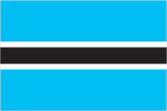
Flag description
light blue with a horizontal white-edged black stripe in the center; the blue symbolizes water in the form of rain, while the black and white bands represent racial harmony
Government type
parliamentary republic
Independence
30 September 1966 (from the UK)
International law organization participation
accepts compulsory ICJ jurisdiction with reservations; accepts ICCt jurisdiction
International organization participation
ACP, AfDB, AU, C, CD, FAO, G-77, IAEA, IBRD, ICAO, ICRM, IDA, IFAD, IFC, IFRCS, ILO, IMF, Interpol, IOC, IOM, IPU, ISO, ITSO, ITU, ITUC (NGOs), MIGA, NAM, OPCW, SACU, SADC, UN, UNCTAD, UNESCO, UNIDO, UNWTO, UPU, WCO, WFTU (NGOs), WHO, WIPO, WMO, WTO
Judicial branch
- Court of Appeal, High Court (each consists of a chief justice and number of other judges as prescribed by the Parliament) Court of Appeal and High Court chief justices appointed by the president and other judges appointed by the president upon the advice of the Judicial Service Commission; all judges appointed to serve until age 70 Industrial Court (with circuits scheduled monthly in the capital city and in three districts); Magistrates Courts (one in each district); Customary Court of Appeal; Paramount Chief's Court/Urban Customary Court; Senior Chief's Representative Court; Chief's Representative’s Court; Headman's Court
- highest court(s)
- Court of Appeal, High Court (each consists of a chief justice and number of other judges as prescribed by the Parliament)
- judge selection and term of office
- Court of Appeal and High Court chief justices appointed by the president and other judges appointed by the president upon the advice of the Judicial Service Commission; all judges appointed to serve until age 70
- subordinate courts
- Industrial Court (with circuits scheduled monthly in the capital city and in three districts); Magistrates Courts (one in each district); Customary Court of Appeal; Paramount Chief's Court/Urban Customary Court; Senior Chief's Representative Court; Chief's Representative’s Court; Headman's Court
Legal system
mixed legal system of civil law influenced by the Roman-Dutch model and also customary and common law
Legislative branch
- bicameral Parliament consists of the House of Chiefs (a largely advisory 35-member body with 8 ex-officio members consisting of the chiefs of the principal tribes, and 27 non-permanent members serving five-year terms, of which 22 are indirectly elected with the remaining 5 appointed by the President) and the National Assembly (63 seats; 57 members directly elected by popular vote, 4 appointed by the majority party, and 2, the President and Attorney General, serve as ex-officio members; members serve five-year terms) National Assembly elections last held on 16 October 2009 (next to be held in 2014) percent of vote by party - BDP 53.3%, BNF 21.9%, BCP 19.2%, BAM 2.3%, other 3.3%; seats by party - BDP 45, BNF 6, BCP 4, BAM 1, other 1
- election results
- percent of vote by party - BDP 53.3%, BNF 21.9%, BCP 19.2%, BAM 2.3%, other 3.3%; seats by party - BDP 45, BNF 6, BCP 4, BAM 1, other 1
- elections
- National Assembly elections last held on 16 October 2009 (next to be held in 2014)
National anthem
- "Fatshe leno la rona" (Our Land) Kgalemang Tumedisco MOTSETE adopted 1966
- lyrics/music
- Kgalemang Tumedisco MOTSETE
- name
- "Fatshe leno la rona" (Our Land)
National holiday
Independence Day (Botswana Day), 30 September (1966)
National symbol(s)
zebra
Political parties and leaders
Botswana Alliance Movement or BAM [Ephraim Lepetu SETSHWAELO]; Botswana Congress Party or BCP [Dumelang SALESHANDO]; Botswana Democratic Party or BDP [Ian KHAMA]; Botswana Movement for Democracy or BMD [Gomolemo MOTSWALEDI]; Botswana National Front or BNF [Duma BOKO]; Botswana Peoples Party or BPP [Motlatsi MOLAPISI]; MELS Movement of Botswana or MELS [Themba JOINA]; New Democratic Front or NDF [Dick BAYFORD] a number of minor parties joined forces in 1999 to form the BAM but did not capture any parliamentary seats - includes the United Action Party [Ephraim Lepetu SETSHWAELO]; the Independence Freedom Party or IFP [Motsamai MPHO]; the Botswana Progressive Union [D. K. KWELE]
Political pressure groups and leaders
- First People of the Kalahari (Bushman organization); Pitso Ya Ba Tswana; Society for the Promotion of Ikalanga Language (Kalanga elites) diamond mining companies
- other
- diamond mining companies
Suffrage
18 years of age; universal
Economy
Agriculture - products
livestock, sorghum, maize, millet, beans, sunflowers, groundnuts
Budget
- $5.04 billion $4.952 billion (2013 est.)
- expenditures
- $4.952 billion (2013 est.)
- revenues
- $5.04 billion
Budget surplus (+) or deficit (-)
0.6% of GDP (2013 est.)
Central bank discount rate
9.5% (31 December 2010 est.) 10% (31 December 2009 est.)
Commercial bank prime lending rate
10% (31 December 2013 est.) 11% (31 December 2012 est.)
Current account balance
$1.375 billion (2013 est.) -$795.2 million (2012 est.)
Debt - external
$2.416 billion (31 December 2013 est.) $2.443 billion (31 December 2012 est.)
Distribution of family income - Gini index
63 (1993)
Economy - overview
Botswana has maintained one of the world's highest economic growth rates since independence in 1966. However, economic growth was negative in 2009, with the industrial sector shrinking by 30%, after the global crisis reduced demand for Botswana's diamonds. Although the economy recovered in 2010, GDP growth has again slowed. Through fiscal discipline and sound management, Botswana transformed itself from one of the poorest countries in the world to a middle-income country with a per capita GDP of $16,400 in 2013. Two major investment services rank Botswana as the best credit risk in Africa. Diamond mining has fueled much of the expansion and currently accounts for more than one-third of GDP, 70-80% of export earnings, and about one-third of the government's revenues. Botswana's heavy reliance on a single luxury export was a critical factor in the sharp economic contraction of 2009. Tourism, financial services, subsistence farming, and cattle raising are other key sectors. According to official government statistics, unemployment reached 17.8% in 2009, but unofficial estimates run much higher. The prevalence of HIV/AIDS is second highest in the world and threatens Botswana's impressive economic gains. An expected leveling off in diamond production within the next two decades overshadows long-term prospects. A major international diamond company signed a 10-year deal with Botswana in 2012 to move its rough stone sorting and trading division from London to Gaborone by the end of 2013. The move may support Botswana's downstream diamond industry.
Exchange rates
pulas (BWP) per US dollar - 8.732 (2013 est.) 7.6181 (2012 est.) 6.7936 (2010 est.) 7.1551 (2009) 6.7907 (2008)
Exports
$7.569 billion (2013 est.) $6.011 billion (2012 est.)
Exports - commodities
diamonds, copper, nickel, soda ash, meat, textiles
Fiscal year
1 April - 31 March
GDP - composition, by end use
- 51.6% 18.3% 34.1% -1.2% 47% -49.8% (2013 est.)
- exports of goods and services
- 47%
- government consumption
- 18.3%
- household consumption
- 51.6%
- imports of goods and services
- -49.8%
- investment in fixed capital
- 34.1%
- investment in inventories
- -1.2%
GDP - composition, by sector of origin
- 1.9% 35.7% 62.4% (2013 est.)
- agriculture
- 1.9%
- industry
- 35.7%
- services
- 62.4% (2013 est.)
GDP - per capita (PPP)
$16,400 (2013 est.) $15,900 (2012 est.) $15,500 (2011 est.) data are in 2013 US dollars
GDP - real growth rate
3.9% (2013 est.) 4.2% (2012 est.) 6.1% (2011 est.)
GDP (official exchange rate)
$15.53 billion (2013 est.)
GDP (purchasing power parity)
$34 billion (2013 est.) $32.71 billion (2012 est.) $31.4 billion (2011 est.) data are in 2013 US dollars
Gross national saving
33.7% of GDP (2013 est.) 28.9% of GDP (2012 est.) 41.1% of GDP (2011 est.)
Household income or consumption by percentage share
- NA% NA%
- highest 10%
- NA%
- lowest 10%
- NA%
Imports
$7.389 billion (2013 est.) $7.918 billion (2012 est.)
Imports - commodities
foodstuffs, machinery, electrical goods, transport equipment, textiles, fuel and petroleum products, wood and paper products, metal and metal products
Industrial production growth rate
7.2% (2013 est.)
Industries
diamonds, copper, nickel, salt, soda ash, potash, coal, iron ore, silver; livestock processing; textiles
Inflation rate (consumer prices)
6.1% (2013 est.) 7.5% (2012 est.)
Labor force
1.308 million (2013 est.)
Labor force - by occupation
- NA% NA% NA%
- agriculture
- NA%
- industry
- NA%
- services
- NA%
Market value of publicly traded shares
$4.588 billion (31 December 2012 est.) $4.107 billion (31 December 2011) $4.076 billion (31 December 2010 est.)
Population below poverty line
30.3% (2003)
Public debt
17.9% of GDP (2013 est.) 17.4% of GDP (2012 est.)
Reserves of foreign exchange and gold
$7.933 billion (31 December 2013 est.) $7.628 billion (31 December 2012 est.)
Stock of broad money
$8.293 billion (31 December 2013 est.) $7.635 billion (31 December 2012 est.)
Stock of domestic credit
$1.38 billion (31 December 2013 est.) $2.111 billion (31 December 2012 est.)
Stock of narrow money
$1.517 billion (31 December 2013 est.) $1.358 billion (31 December 2012 est.)
Taxes and other revenues
32.4% of GDP (2013 est.)
Unemployment rate
17.8% (2009 est.) 7.5% (2007 est.)
Energy
Carbon dioxide emissions from consumption of energy
3.843 million Mt (2011 est.)
Crude oil - exports
0 bbl/day (2010 est.)
Crude oil - imports
0 bbl/day (2010 est.)
Crude oil - production
0 bbl/day (2012 est.)
Crude oil - proved reserves
0 bbl (1 January 2013 est.)
Electricity - consumption
3.118 billion kWh (2011 est.)
Electricity - exports
0 kWh (2012 est.)
Electricity - from fossil fuels
100% of total installed capacity (2010 est.)
Electricity - from hydroelectric plants
0% of total installed capacity (2010 est.)
Electricity - from nuclear fuels
0% of total installed capacity (2010 est.)
Electricity - from other renewable sources
0% of total installed capacity (2010 est.)
Electricity - imports
2.985 billion kWh (2010 est.)
Electricity - installed generating capacity
132,000 kW (2011 est.)
Electricity - production
429.6 million kWh (2010 est.)
Natural gas - consumption
0 cu m (2010 est.)
Natural gas - exports
0 cu m (2011 est.)
Natural gas - imports
0 cu m (2011 est.)
Natural gas - production
0 cu m (2011 est.)
Natural gas - proved reserves
0 cu m (1 January 2013 est.)
Refined petroleum products - consumption
15,420 bbl/day (2011 est.)
Refined petroleum products - exports
0 bbl/day (2010 est.)
Refined petroleum products - imports
19,360 bbl/day (2010 est.)
Refined petroleum products - production
0 bbl/day (2010 est.)
Communications
Broadcast media
2 TV stations - 1 state-owned and 1 privately owned; privately owned satellite TV subscription service is available; 2 state-owned national radio stations; 3 privately owned radio stations broadcast locally (2007)
Internet country code
.bw
Internet hosts
1,806 (2012)
Internet users
120,000 (2009)
Telephone system
- Botswana is participating in regional development efforts; expanding fully digital system with fiber-optic cables linking the major population centers in the east as well as a system of open-wire lines, microwave radio relays links, and radiotelephone communication stations fixed-line teledensity has declined in recent years and now stands at roughly 7 telephones per 100 persons; mobile-cellular teledensity now pushing 140 telephones per 100 persons country code - 267; international calls are made via satellite, using international direct dialing; 2 international exchanges; digital microwave radio relay links to Namibia, Zambia, Zimbabwe, and South Africa; satellite earth station - 1 Intelsat (Indian Ocean) (2011)
- domestic
- fixed-line teledensity has declined in recent years and now stands at roughly 7 telephones per 100 persons; mobile-cellular teledensity now pushing 140 telephones per 100 persons
- general assessment
- Botswana is participating in regional development efforts; expanding fully digital system with fiber-optic cables linking the major population centers in the east as well as a system of open-wire lines, microwave radio relays links, and radiotelephone communication stations
- international
- country code - 267; international calls are made via satellite, using international direct dialing; 2 international exchanges; digital microwave radio relay links to Namibia, Zambia, Zimbabwe, and South Africa; satellite earth station - 1 Intelsat (Indian Ocean) (2011)
Telephones - main lines in use
160,500 (2012)
Telephones - mobile cellular
3.082 million (2012)
Transportation
Airports
74 (2013)
Airports - with paved runways
- 1 (2013)
- 1,524 to 2,437 m
- 6
- 2,438 to 3,047 m
- 1
- 914 to 1,523 m
- 1 (2013)
- over 3,047 m
- 2
- total
- 10
Airports - with unpaved runways
- 13 (2013)
- 1,524 to 2,437 m
- 5
- 914 to 1,523 m
- 46
- total
- 64
Railways
- 888 km 888 km 1.067-m gauge (2008)
- total
- 888 km
Roadways
- 17,916 km includes 8,916 km of Public Highway Network roads (6,116 km paved and 2,800 km unpaved) and other 9,000 km of District Council roads (2011)
- total
- 17,916 km
Military and Security
Manpower available for military service
- 557,647 531,095 (2010 est.)
- females age 16-49
- 531,095 (2010 est.)
- males age 16-49
- 557,647
Manpower fit for military service
- 340,949 302,332 (2010 est.)
- females age 16-49
- 302,332 (2010 est.)
- males age 16-49
- 340,949
Manpower reaching militarily significant age annually
- 23,649 23,063 (2010 est.)
- female
- 23,063 (2010 est.)
- male
- 23,649
Military branches
- Botswana Defense Force (BDF): Ground Forces Command, Air Wing Command, Defense Logistics Command, Special Forces Group (2013)
- Botswana Defense Force (BDF)
- Ground Forces Command, Air Wing Command, Defense Logistics Command, Special Forces Group (2013)
Military expenditures
2.31% of GDP (2012) 2.43% of GDP (2011) 2.31% of GDP (2010)
Military service age and obligation
18 is the legal minimum age for voluntary military service; no conscription (2012)
Transnational Issues
Disputes - international
none