1996 Edition
CIA World Factbook 1996 (Project Gutenberg)
Introduction
Description
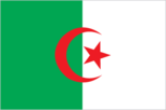
two equal vertical bands of green (hoist side) and white with a red, five-pointed star within a red crescent; the crescent, star, and color green are traditional symbols of Islam (the state religion)
Location
28 00 N, 3 00 E -- Northern Africa, bordering the Mediterranean Sea, between Morocco and Tunisia Flag ----
Geography
Area
- comparative area
- slightly less than 3.5 times the size of Texas
- land area
- 2,381,740 sq km
- total area
- 2,381,740 sq km
Climate
arid to semiarid; mild, wet winters with hot, dry summers along coast; drier with cold winters and hot summers on high plateau; sirocco is a hot, dust/sand-laden wind especially common in summer
Coastline
998 km
Environment
- current issues
- soil erosion from overgrazing and other poor farming practices; desertification; dumping of raw sewage, petroleum refining wastes, and other industrial effluents is leading to the pollution of rivers and coastal waters; Mediterranean Sea, in particular, becoming polluted from oil wastes, soil erosion, and fertilizer runoff; inadequate supplies of potable water
- international agreements
- party to - Biodiversity, Climate Change, Endangered Species, Environmental Modification, Ozone Layer Protection, Ship Pollution, Wetlands; signed, but not ratified - Desertification, Law of the Sea, Nuclear Test Ban
- natural hazards
- mountainous areas subject to severe earthquakes; mud slides
Geographic coordinates
28 00 N, 3 00 E
Geographic note
second-largest country in Africa (after Sudan)
International disputes
part of southeastern region claimed by Libya; land boundary dispute with Tunisia settled in 1993
Irrigated land
3,360 sq km (1989 est.)
Land boundaries
- border countries
- Libya 982 km, Mali 1,376 km, Mauritania 463 km, Morocco 1,559 km, Niger 956 km, Tunisia 965 km, Western Sahara 42 km
- total
- 6,343 km
Land use
- arable land
- 3%
- forest and woodland
- 2%
- meadows and pastures
- 13%
- other
- 82%
- permanent crops
- 0%
Location
Northern Africa, bordering the Mediterranean Sea, between Morocco and Tunisia
Map references
Africa
Maritime claims
- exclusive fishing zone
- 32-52 nm
- territorial sea
- 12 nm
Natural resources
petroleum, natural gas, iron ore, phosphates, uranium, lead, zinc
Terrain
- mostly high plateau and desert; some mountains; narrow, discontinuous coastal plain
- highest point
- Tahat 3,003 m
- lowest point
- Chott Melrhir -40 m
People and Society
Age structure
0-14 years: 40% (male 5,910,543; female 5,701,647) 15-64 years: 56% (male 8,319,650; female 8,162,816) 65 years and over: 4% (male 510,308; female 578,068) (July 1996 est.)
Birth rate
28.51 births/1,000 population (1996 est.)
Death rate
5.9 deaths/1,000 population (1996 est.)
Ethnic divisions
Arab-Berber 99%, European less than 1%
Infant mortality rate
48.7 deaths/1,000 live births (1996 est.)
Languages
Arabic (official), French, Berber dialects
Life expectancy at birth
- female
- 69.46 years (1996 est.)
- male
- 67.22 years
- total population
- 68.31 years
Literacy
- age 15 and over can read and write (1995 est.)
- female
- 49%
- male
- 73.9%
- total population
- 61.6%
Nationality
- adjective
- Algerian
- noun
- Algerian(s)
Net migration rate
-0.49 migrant(s)/1,000 population (1996 est.)
Population
29,183,032 (July 1996 est.)
Population growth rate
2.21% (1996 est.)
Religions
Sunni Muslim (state religion) 99%, Christian and Jewish 1%
Sex ratio
- all ages
- 1.02 male(s)/female (1996 est.)
- at birth
- 1.04 male(s)/female
- under 15 years
- 1.04 male(s)/female 15-64 years: 1.02 male(s)/female 65 years and over: 0.88 male(s)/female
Total fertility rate
3.59 children born/woman (1996 est.)
Government
Administrative divisions
48 provinces (wilayas, singular - wilaya); Adrar, Ain Defla, Ain Temouchent, Alger, Annaba, Batna, Bechar, Bejaia, Biskra, Blida, Bordj Bou Arreridj, Bouira, Boumerdes, Chlef, Constantine, Djelfa, El Bayadh, El Oued, El Tarf, Ghardaia, Guelma, Illizi, Jijel, Khenchela, Laghouat, Mascara, Medea, Mila, Mostaganem, M'Sila, Naama, Oran, Ouargla, Oum el Bouaghi, Relizane, Saida, Setif, Sidi Bel Abbes, Skikda, Souk Ahras, Tamanghasset, Tebessa, Tiaret, Tindouf, Tipaza, Tissemsilt, Tizi Ouzou, Tlemcen
Capital
Algiers
Constitution
19 November 1976, effective 22 November 1976; revised 3 November 1988 and 23 February 1989
Data code
AG
Diplomatic representation in US
- chancery
- 2118 Kalorama Road NW, Washington, DC 20008
- chief of mission
- Ambassador Osmane BENCHERIF
- telephone
- [1] (202) 265-2800
Executive branch
- cabinet
- Council of Ministers was appointed by the prime minister
- chief of state
- President Liamine ZEROUAL (appointed president 31 January 1994, elected president 16 November 1995) was elected for a five-year term by universal suffrage; election last held 16 November 1995 (next to be held NA); results - percent of vote NA
- head of government
- Prime Minister Ahmed OUYAHIA (since 31 December 1995) was appointed by the president
FAX
[213] (2) 69-39-79
Flag
two equal vertical bands of green (hoist side) and white with a red, five-pointed star within a red crescent; the crescent, star, and color green are traditional symbols of Islam (the state religion)
Independence
5 July 1962 (from France)
International organization participation
ABEDA, AfDB, AFESD, AL, AMF, AMU, CCC, ECA, FAO, G-15, G-19, G-24, G-77, IAEA, IBRD, ICAO, ICRM, IDA, IDB, IFAD, IFC, IFRCS, ILO, IMF, IMO, Intelsat, Interpol, IOC, ISO, ITU, NAM, OAPEC, OAS (observer), OAU, OIC, OPEC, OSCE (partner), UN, UNAVEM III, UNCTAD, UNESCO, UNHCR, UNIDO, UNMIH, UPU, WCL, WHO, WIPO, WMO, WToO, WTrO (applicant)
Judicial branch
Supreme Court (Cour Supreme)
Legal system
socialist, based on French and Islamic law; judicial review of legislative acts in ad hoc Constitutional Council composed of various public officials, including several Supreme Court justices; has not accepted compulsory ICJ jurisdiction
Legislative branch
unicameral; note - suspended since 1992
Name of country
- conventional long form
- Democratic and Popular Republic of Algeria
- conventional short form
- Algeria
- local long form
- Al Jumhuriyah al Jaza'iriyah ad Dimuqratiyah ash Shabiyah
- local short form
- Al Jaza'ir
National holiday
Anniversary of the Revolution, 1 November (1954)
National People's Assembly (Al-Majlis Ech-Chaabi Al-Watani)
first-round elections held 26 December 1991; second round canceled by the military after President BENDJEDID resigned 11 January 1992, effectively suspending the assembly (next election promised by late 1996 or early 1997); results - percent of vote by party NA; seats - (281 total) the fundamentalist FIS won 188 of the 231 seats contested in the first round
Political parties and leaders
- Islamic Salvation Front (FIS, outlawed April 1992), Ali BELHADJ, Dr. Abassi MADANI, Rabeh KEBIR (self-exile in Germany); National Liberation Front (FLN), Boualem BENHAMOUDA, secretary general; Socialist Forces Front (FFS), Hocine Ait AHMED, secretary general (self-exile in Switzerland); Hamas, Mahfoud NAHNAH, chairman; Rally for Culture and Democracy (RCD), Said SAADI, secretary general; Algerian Renewal Party (PRA), Noureddine BOUKROUH, chairman
- note
- the government established a multiparty system in September 1989 and, as of 31 December 1990, over 50 legal parties existed
Suffrage
18 years of age; universal
Type of government
republic
US diplomatic representation
- chief of mission
- Ambassador Ronald E. NEUMANN
- embassy
- 4 Chemin Cheikh Bachir El-Ibrahimi, Algiers
- mailing address
- B. P. Box 549, Alger-Gare, 16000 Algiers
- telephone
- [213] (2) 69-11-86, 69-18-54, 69-38-75, 69-12-55
Economy
Agriculture
wheat, barley, oats, grapes, olives, citrus, fruits; sheep, cattle
Budget
- expenditures
- $17.9 billion, including capital expenditures of $NA (1995 est.)
- revenues
- $14.3 billion
Currency
1 Algerian dinar (DA) = 100 centimes
Economic aid
- recipient
- ODA, $316 million (1993)
Economic overview
The hydrocarbons sector is the backbone of the economy, accounting for roughly 57% of government revenues, 25% of GDP, and almost all export earnings; Algeria has the fifth-largest reserves of natural gas in the world and ranks fourteenth for oil. Algiers' efforts to reform one of the most centrally planned economies in the Arab world began after the 1986 collapse of world oil prices plunged the country into a severe recession. In 1989, the government launched a comprehensive, IMF-supported program to achieve economic stabilization and to introduce market mechanisms into the economy. Despite substantial progress toward economic adjustment, in 1992 the reform drive stalled as Algiers became embroiled in political turmoil. In September 1993, a new government was formed, and one priority was the resumption and acceleration of the structural adjustment process. Buffeted by the slump in world oil prices and burdened with a heavy foreign debt, Algiers concluded a one-year standby arrangement with the IMF in April 1994. Following a Paris Club debt rescheduling in 1995 and a robust harvest, the economy experienced a strong recovery and key economic improvements.
Electricity
- capacity
- 5,370,000 kW
- consumption per capita
- 587 kWh (1993)
- production
- 18.3 billion kWh
Exchange rates
Algerian dinars (DA) per US$1 - 53.003 (January 1996), 47.663 (1995), 35.059 (1994), 23.345 (1993), 21.836 (1992), 18.473 (1991)
Exports
- $9.5 billion (f.o.b., 1995 est.)
- commodities
- petroleum and natural gas 97%
- partners
- Italy 21%, France 16%, US 14%, Germany 13%, Spain 9%
External debt
$26 billion (1994)
Fiscal year
calendar year
GDP
purchasing power parity - $108.7 billion (1995 est.)
GDP composition by sector
- agriculture
- 12%
- industry
- 50%
- services
- 38%
GDP per capita
$3,800 (1995 est.)
GDP real growth rate
3.5% (1995 est.)
Imports
- $10.6 billion (f.o.b., 1995 est.)
- commodities
- capital goods 39.7%, food and beverages 21.7%, consumer goods 11.8% (1990)
- partners
- France 29%, Italy 14%, Spain 9%, US 9%, Germany 7%
Industrial production growth rate
NA%
Industries
petroleum, light industries, natural gas, mining, electrical, petrochemical, food processing
Inflation rate (consumer prices)
28% (1995 est.)
Labor force
- 6.2 million (1992 est.)
- by occupation
- government 29.5%, agriculture 22%, construction and public works 16.2%, industry 13.6%, commerce and services 13.5%, transportation and communication 5.2% (1989)
Unemployment rate
25% (1995 est.)
Communications
Branches
National Popular Army, Navy, Air Force, Territorial Air Defense, National Gendarmerie
Defense expenditures
exchange rate conversion - $1.3 billion, 2.7% of GDP (1994)
Manpower availability
- males age 15-49
- 7,391,946
- males fit for military service
- 4,534,267
- males reach military age (19) annually
- 326,229 (1996 est.)
Radio broadcast stations
AM 26, FM 0, shortwave 0
Radios
6 million (1991 est.)
Telephone system
- domestic
- excellent service in north but sparse in south; domestic satellite system with 12 earth stations (20 additional domestic earth stations are planned)
- international
- 5 submarine cables; microwave radio relay to Italy, France, Spain, Morocco, and Tunisia; coaxial cable to Morocco and Tunisia; participant in Medarabtel; satellite earth stations - 2 Intelsat (1 Atlantic Ocean and 1 Indian Ocean), 1 Intersputnik, and 1 Arabsat
Telephones
862,000 (1991 est.)
Television broadcast stations
18
Televisions
2 million (1993 est.) Defense
Transportation
Airports
- total
- 119
- with paved runways 1 524 to 2 437 m
- 13
- with paved runways 2 438 to 3 047 m
- 24
- with paved runways 914 to 1 523 m
- 4
- with paved runways over 3 047 m
- 8
- with paved runways under 914 m
- 17
- with unpaved runways 1 524 to 2 437 m
- 19
- with unpaved runways 2 438 to 3 047 m
- 3
- with unpaved runways 914 to 1 523 m
- 31 (1995 est.)
Heliports
1 (1995 est.)
Highways
- paved
- 63,080 km (including 400 km of expressways)
- total
- 95,576 km
- unpaved
- 32,496 km (1992 est.)
Merchant marine
- ships by type
- bulk 9, cargo 27, chemical tanker 7, liquefied gas tanker 10, oil tanker 5, roll-on/roll-off cargo 13, short-sea passenger 5, specialized tanker 1 (1995 est.)
- total
- 77 ships (1,000 GRT or over) totaling 916,701 GRT/1,086,324 DWT
Pipelines
crude oil 6,612 km; petroleum products 298 km; natural gas 2,948 km
Ports
Algiers, Annaba, Arzew, Bejaia, Beni Saf, Dellys, Djendjene, Ghazaouet, Jijel, Mostaganem, Oran, Skikda, Tenes
Railways
- narrow gauge
- 1,156 km 1.055-m gauge
- standard gauge
- 3,616 km 1.435-m gauge (301 km electrified; 215 km double track)
- total
- 4,772 km