2003 Edition
CIA World Factbook 2003 (Project Gutenberg)
Introduction
Administrative divisions
8 provinces and 2 cities* with provincial status; Bulawayo*, Harare*, Manicaland, Mashonaland Central, Mashonaland East, Mashonaland West, Masvingo, Matabeleland North, Matabeleland South, Midlands
Age structure
0-14 years: 39.7% (male 2,517,608; female 2,471,342) 15-64 years: 56.8% (male 3,600,832; female 3,542,497) 65 years and over: 3.5% (male 224,631; female 219,832) (2003 est.)
Area
- land
- 386,670 sq km
- total
- 390,580 sq km
- water
- 3,910 sq km
Area - comparative
slightly larger than Montana
Background
The UK annexed Southern Rhodesia from the South Africa Company in 1923. A 1961 constitution was formulated that favored whites in power. In 1965 the government unilaterally declared its independence, but the UK did not recognize the act and demanded more complete voting rights for the black African majority in the country (then called Rhodesia). UN sanctions and a guerrilla uprising finally led to free elections in 1979 and independence (as Zimbabwe) in 1980. Robert MUGABE, the nation's first prime minister, has been the country's only ruler (as president since 1987) and has dominated the country's political system since independence. His chaotic land redistribution campaign begun in 2000 caused an exodus of white farmers, crippled the economy, and ushered in widespread shortages of basic commodities. Ignoring international condemnation, MUGABE rigged the 2002 presidential election to ensure his reelection. Opposition and labor groups launched general strikes in 2003 to pressure MUGABE to retire early; security forces continued their brutal repression of regime opponents. Geography Zimbabwe
Birth rate
30.34 births/1,000 population (2003 est.)
Capital
Harare
Climate
tropical; moderated by altitude; rainy season (November to March)
Coastline
0 km (landlocked)
Constitution
21 December 1979
Country name
- conventional long form
- Republic of Zimbabwe
- conventional short form
- Zimbabwe
- former
- Southern Rhodesia, Rhodesia
Death rate
22.02 deaths/1,000 population (2003 est.)
Diplomatic representation from the US
- chief of mission
- Ambassador Joseph G. SULLIVAN
- embassy
- 172 Herbert Chitepo Avenue, Harare
- mailing address
- P. O. Box 3340, Harare
- telephone
- [263] (4) 250-593 and 250-594
Diplomatic representation in the US
- chief of mission
- Ambassador Simbi Veke MUBAKO
Elevation extremes
- highest point
- Inyangani 2,592 m
- lowest point
- junction of the Runde and Save rivers 162 m
Environment - current issues
deforestation; soil erosion; land degradation; air and water pollution; the black rhinoceros herd - once the largest concentration of the species in the world - has been significantly reduced by poaching; poor mining practices have led to toxic waste and heavy metal pollution
Environment - international agreements
- party to
- Biodiversity, Climate Change, Desertification, Endangered Species, Law of the Sea, Ozone Layer Protection
- signed, but not ratified
- none of the selected agreements
Ethnic groups
African 98% (Shona 82%, Ndebele 14%, other 2%), mixed and Asian 1%, white less than 1%
Executive branch
- cabinet
- Cabinet appointed by the president; responsible to the House of Assembly
- chief of state
- Executive President Robert Gabriel MUGABE (since 31 December 1987); Joseph MSIKA (since 23 December 1999); note - the president is both the chief of state and head of government
- election results
- Robert Gabriel MUGABE reelected president; percent of vote - Robert Gabriel MUGABE 56.2%, Morgan TSVANGIRAI 41.9%
- elections
- presidential candidates nominated with a nomination paper signed by at least 10 registered voters (at least one from each province) and elected by popular vote; election last held 9-11 March 2002 (next to be held NA March 2008); co-vice presidents appointed by the president
- head of government
- Executive President Robert Gabriel MUGABE (since 31 December 1987); Joseph MSIKA (since 23 December 1999); note - the president is both the chief of state and head of government
FAX
- [1] (202) 483-9326
- [263] (4) 796488
- chancery
- 1608 New Hampshire Avenue NW, Washington, DC 20009
- telephone
- [1] (202) 332-7100
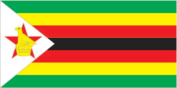
Flag description
seven equal horizontal bands of green, yellow, red, black, red, yellow, and green with a white isosceles triangle edged in black with its base on the hoist side; a yellow Zimbabwe bird representing the long history of the country is superimposed on a red five-pointed star in the center of the triangle, which symbolizes peace; green symbolizes agriculture, yellow - mineral wealth, red - blood shed to achieve independence, and black stands for the native
Geographic coordinates
20 00 S, 30 00 E
Geography - note
landlocked; the Zambezi forms a natural riverine boundary with Zambia; in full flood (February-April) the massive Victoria Falls on the river forms the world's largest curtain of falling water People Zimbabwe
Government type
parliamentary democracy
HIV/AIDS - adult prevalence rate
33.7% (2001 est.)
HIV/AIDS - deaths
200,000 (2001 est.)
HIV/AIDS - people living with HIV/AIDS
2.3 million (2001 est.)
Independence
18 April 1980 (from UK)
Infant mortality rate
- female
- 63.69 deaths/1,000 live births (2003 est.)
- male
- 69.17 deaths/1,000 live births
- total
- 66.47 deaths/1,000 live births
International organization participation
ACP, AfDB, C, ECA, FAO, G-15, G-77, IAEA, IBRD, ICAO, ICCt (signatory), ICFTU, ICRM, IDA, IFAD, IFC, IFRCS, ILO, IMF, Interpol, IOC, IOM, ISO, ITU, NAM, OAU, OPCW, PCA, SADC, UN, UNCTAD, UNESCO, UNIDO, UNMIK, UPU, WCL, WCO, WFTU, WHO, WIPO, WMO, WToO, WTrO
Irrigated land
1,170 sq km (1998 est.)
Judicial branch
Supreme Court; High Court
Land boundaries
- border countries
- Botswana 813 km, Mozambique 1,231 km, South Africa 225 km, Zambia 797 km
- total
- 3,066 km
Land use
- arable land
- 8.4%
- other
- 91.26% (1998 est.)
- permanent crops
- 0.34%
Languages
English (official), Shona, Sindebele (the language of the Ndebele, sometimes called Ndebele), numerous but minor tribal dialects
Legal system
mixture of Roman-Dutch and English common law
Legislative branch
- unicameral House of Assembly (150 seats - 120 elected by popular vote for five-year terms, 12 nominated by the president, 10 occupied by traditional chiefs chosen by their peers, and 8 occupied by provincial governors appointed by the president)
- election results
- percent of vote by party - ZANU-PF 48.6%, MDC 47.0%, other 4.4%; seats by party - ZANU-PF 62, MDC 57, ZANU-Ndonga 1
- elections
- last held 24-25 June 2000 (next to be held NA 2005)
Life expectancy at birth
- female
- 37.89 years (2003 est.)
- male
- 40.09 years
- total population
- 39.01 years
Literacy
- definition
- age 15 and over can read and write English
- female
- 87.2% (2003 est.) Government Zimbabwe
- male
- 94.2%
- total population
- 90.7%
Location
Southern Africa, between South Africa and Zambia
Map references
Africa
Maritime claims
none (landlocked)
Median age
- female
- 18.9 years (2002)
- male
- 18.9 years
- total
- 18.9 years
National holiday
Independence Day, 18 April (1980)
Nationality
- adjective
- Zimbabwean
- noun
- Zimbabwean(s)
Natural hazards
recurring droughts; floods and severe storms are rare
Natural resources
coal, chromium ore, asbestos, gold, nickel, copper, iron ore, vanadium, lithium, tin, platinum group metals
Net migration rate
- NEGL migrant(s)/1,000 population
- note
- there is an increasing flow of Zimbabweans into South Africa and Botswana in search of better economic opportunities (2003 est.)
Political parties and leaders
Movement for Democratic Change or MDC [Morgan TSVANGIRAI]; National Alliance for Good Governance or NAGG [Shakespeare MAYA]; United Parties [Abel MUZOREWA]; Zimbabwe African National Union-Ndonga or ZANU-Ndonga [Wilson KUMBULA]; Zimbabwe African National Union-Patriotic Front or ZANU-PF [Robert Gabriel MUGABE]; Zimbabwe African Peoples Union or ZAPU [Agrippa MADLELA]
Political pressure groups and leaders
National Constitutional Assembly or NCA [Lovemore MADHUKU]; Crisis in Zimbabwe Coalition [Brian KAGORO]; Zimbabwe Congress of Trade Unions or ZCTU [Lovemore MATOMBO]
Population
- 12,576,742
- note
- estimates for this country explicitly take into account the effects of excess mortality due to AIDS; this can result in lower life expectancy, higher infant mortality and death rates, lower population and growth rates, and changes in the distribution of population by age and sex than would otherwise be expected (July 2003 est.)
Population growth rate
0.83% (2003 est.)
Religions
syncretic (part Christian, part indigenous beliefs) 50%, Christian 25%, indigenous beliefs 24%, Muslim and other 1%
Sex ratio
- at birth
- 1.03 male(s)/female
- total population
- 1.02 male(s)/female (2003 est.)
- under 15 years
- 1.02 male(s)/female 15-64 years: 1.02 male(s)/female 65 years and over: 1.02 male(s)/female
Suffrage
18 years of age; universal
Terrain
mostly high plateau with higher central plateau (high veld); mountains in east
Total fertility rate
3.66 children born/woman (2003 est.)
People and Society
Agriculture - products
corn, cotton, tobacco, wheat, coffee, sugarcane, peanuts; cattle, sheep, goats, pigs
Airports
430 (2002)
Airports - with paved runways
- over 3,047 m
- 3 2,438 to 3,047 m: 2 1,524 to 2,437 m: 4 914 to 1,523 m: 8 (2002)
- total
- 17
Airports - with unpaved runways
- total
- 413 1,524 to 2,437 m: 4 914 to 1,523 m: 197
- under 914 m
- 212 (2002) Military Zimbabwe
Budget
- expenditures
- $2.6 billion, including capital expenditures of $NA (2000)
- revenues
- $2.5 billion
Currency
Zimbabwean dollar (ZWD)
Currency code
ZWD
Debt - external
$3.9 billion (2002 est.)
Disputes - international
dormant dispute remains where Botswana, Namibia, Zambia, and Zimbabwe boundaries converge
Distribution of family income - Gini index
50.1 (1995)
Economic aid - recipient
$178 million (2000 est.)
Economy - overview
The government of Zimbabwe faces a wide variety of difficult economic problems as it struggles with an unsustainable fiscal deficit, an overvalued exchange rate, soaring inflation, and bare shelves. Its 1998-2002 involvement in the war in the Democratic Republic of the Congo, for example, drained hundreds of millions of dollars from the economy. Badly needed support from the IMF has been suspended because of the country's failure to meet budgetary goals. Inflation rose from an annual rate of 32% in 1998 to 59% in 1999, to 60% in 2000, to over 100% by yearend 2001, to 228% in early 2003. The government's land reform program, characterized by chaos and violence, has nearly destroyed the commercial farming sector, the traditional source of exports and foreign exchange and the provider of 400,000 jobs.
Electricity - consumption
9.813 billion kWh (2001)
Electricity - exports
0 kWh (2001)
Electricity - imports
3.55 billion kWh (2001)
Electricity - production
6.735 billion kWh (2001)
Electricity - production by source
- fossil fuel
- 47%
- hydro
- 53%
- nuclear
- 0%
- other
- 0% (2001)
Exchange rates
Zimbabwean dollars per US dollar - 55 (2002), 55.05 (2001), 44.42 (2000), 38.3 (1999), 23.68 (1998)
Exports
$1.57 billion f.o.b. (2001 est.)
Exports - commodities
tobacco, gold, ferroalloys, textiles/clothing
Exports - partners
China 6%, South Africa 5.7%, Germany 5.4%, UK 4.8%, Japan 4.7%, Netherlands 4.4%, US 4.1% (2002)
Fiscal year
1 January - 31 December Communications Zimbabwe
GDP
purchasing power parity - $26.07 billion (2002 est.)
GDP - composition by sector
- agriculture
- 18%
- industry
- 24%
- services
- 58% (2001)
GDP - per capita
purchasing power parity - $2,100 (2002 est.)
GDP - real growth rate
-13% (2002 est.)
Highways
- paved
- 8,692 km
- total
- 18,338 km
- unpaved
- 9,646 km (1999 est.)
Household income or consumption by percentage share
- highest 10%
- 40.42% (1995)
- lowest 10%
- 1.97%
Illicit drugs
transit point for African cannabis and South Asian heroin, mandrax, and methamphetamines destined for the South African and European markets This page was last updated on 18 December, 2003
Imports
$1.739 billion f.o.b. (2001 est.)
Imports - commodities
machinery and transport equipment, other manufactures, chemicals, fuels
Imports - partners
South Africa 47.7%, Congo, Democratic Republic of the 5.7%, Mozambique 5.3% (2002)
Industrial production growth rate
-3.1% (2002 est.)
Industries
mining (coal, gold, copper, nickel, tin, clay, numerous metallic and nonmetallic ores), steel, wood products, cement, chemicals, fertilizer, clothing and footwear, foodstuffs, beverages
Inflation rate (consumer prices)
134.5% (2002 est.)
Internet country code
.zw
Internet Service Providers (ISPs)
6 (2000)
Internet users
100,000 (2002) Transportation Zimbabwe
Labor force
5.8 million (2000 est.)
Labor force - by occupation
agriculture 66%, services 24%, industry 10% (1996)
Military branches
Zimbabwe National Army, Air Force of Zimbabwe, Zimbabwe Republic Police (includes Police Support Unit, Paramilitary Police)
Military expenditures - dollar figure
$625.1 million (FY02)
Military expenditures - percent of GDP
3.2% (FY02) Transnational Issues Zimbabwe
Military manpower - availability
- males age 15-49
- 3,236,042 (2003 est.)
Military manpower - fit for military service
- males age 15-49
- 2,003,572 (2003 est.)
Oil - consumption
23,000 bbl/day (2001 est.)
Oil - exports
NA (2001)
Oil - imports
NA (2001)
Oil - production
0 bbl/day (2001 est.)
Pipelines
refined products 261 km (2003)
Population below poverty line
70% (2002 est.)
Ports and harbors
Binga, Kariba
Radio broadcast stations
AM 7, FM 20 (plus 17 repeater stations), shortwave 1 (1998)
Radios
1.14 million (1997)
Railways
- narrow gauge
- 3,077 km 1.067-m gauge (313 km electrified)
- note
- includes the 318 km Bulawayo-Beitbridge Railway Company line (2002)
- total
- 3,077 km
Telephone system
- domestic
- consists of microwave radio relay links, open-wire lines, radiotelephone communication stations, fixed wireless local loop installations, and a substantial mobile cellular network; Internet connection is available in Harare and planned for all major towns and for some of the smaller ones
- general assessment
- system was once one of the best in Africa, but now suffers from poor maintenance; more than 100,000 outstanding requests for connection despite an equally large number of installed but unused main lines
- international
- satellite earth stations - 2 Intelsat; two international digital gateway exchanges (in Harare and Gweru)
Telephones - main lines in use
212,000 (in addition, there are about 20,000 fixed telephones in wireless local loop connections) (1997)
Telephones - mobile cellular
111,000 (2001)
Television broadcast stations
16 (1997)
Televisions
370,000 (1997)
Unemployment rate
70% (2002 est.)
Waterways
chrome ore is transported from Harare - by way of the Mazoe River - to the Zambezi River in Mozambique