2000 Edition
CIA World Factbook 2000 (Project Gutenberg)
Introduction
Background
The UK annexed Southern Rhodesia from the South Africa Company in 1923. A 1961 constitution was formulated to keep whites in power. In 1965 the government unilaterally declared its independence, but the UK did not recognize the act and demanded voting rights for the black African majority in the country (then called Rhodesia). UN sanctions and a guerrilla uprising finally led to free elections in 1979 and independence (as Zimbabwe) in 1980. Robert MUGABE, the nation's first prime minister, has been the country's only ruler (as president since 1987) and has dominated the country's political system since independence.
Geography
Area
- land
- 386,670 sq km
- total
- 390,580 sq km
- water
- 3,910 sq km
Area - comparative
slightly larger than Montana
Climate
tropical; moderated by altitude; rainy season (November to March)
Coastline
0 km (landlocked)
Elevation extremes
- highest point
- Inyangani 2,592 m
- lowest point
- junction of the Runde and Save rivers 162 m
Environment - current issues
deforestation; soil erosion; land degradation; air and water pollution; the black rhinoceros herd - once the largest concentration of the species in the world - has been significantly reduced by poaching
Environment - international agreements
- party to
- Biodiversity, Climate Change, Desertification, Endangered Species, Law of the Sea, Ozone Layer Protection signed, but not ratified: none of the selected agreements
Geographic coordinates
20 00 S, 30 00 E
Geography - note
landlocked
Irrigated land
1,930 sq km (1993 est.)
Land boundaries
- border countries
- Botswana 813 km, Mozambique 1,231 km, South Africa 225 km, Zambia 797 km
- total
- 3,066 km
Land use
- arable land
- 7%
- forests and woodland
- 23%
- other
- 57% (1993 est.)
- permanent crops
- 0%
- permanent pastures
- 13%
Location
Southern Africa, between South Africa and Zambia
Map references
Africa
Maritime claims
none (landlocked)
Natural hazards
recurring droughts; floods and severe storms are rare
Natural resources
coal, chromium ore, asbestos, gold, nickel, copper, iron ore, vanadium, lithium, tin, platinum group metals
Terrain
mostly high plateau with higher central plateau (high veld); mountains in east
People and Society
Age structure
0-14 years: 39.64% (male 2,274,128; female 2,222,277) 15-64 years: 56.82% (male 3,251,860; female 3,192,888) 65 years and over: 3.54% (male 204,028; female 197,340) (2000 est.)
Birth rate
25 births/1,000 population (2000 est.)
Death rate
22.43 deaths/1,000 population (2000 est.)
Ethnic groups
African 98% (Shona 71%, Ndebele 16%, other 11%), white 1%, mixed and Asian 1%
Infant mortality rate
62.25 deaths/1,000 live births (2000 est.)
Languages
English (official), Shona, Sindebele (the language of the Ndebele, sometimes called Ndebele), numerous but minor tribal dialects
Life expectancy at birth
- female
- 36.34 years (2000 est.)
- male
- 39.18 years
- total population
- 37.78 years
Literacy
- definition
- age 15 and over can read and write English
- female
- 80% (1995 est.)
- male
- 90%
- total population
- 85%
Nationality
- adjective
- Zimbabwean
- noun
- Zimbabwean(s)
Net migration rate
- 0 migrant(s)/1,000 population (2000 est.)
- note
- there is a small but steady flow of Zimbabweans into South Africa in search of better paid employment
Population
- 11,342,521
- note
- estimates for this country explicitly take into account the effects of excess mortality due to AIDS; this can result in lower life expectancy, higher infant mortality and death rates, lower population and growth rates, and changes in the distribution of population by age and sex than would otherwise be expected (July 2000 est.)
Population growth rate
0.26% (2000 est.)
Religions
syncretic (part Christian, part indigenous beliefs) 50%, Christian 25%, indigenous beliefs 24%, Muslim and other 1%
Sex ratio
- at birth
- 1.03 male(s)/female under 15 years: 1.02 male(s)/female 15-64 years: 1.02 male(s)/female 65 years and over: 1.03 male(s)/female
- total population
- 1.02 male(s)/female (2000 est.)
Total fertility rate
3.34 children born/woman (2000 est.)
Government
Administrative divisions
8 provinces and 2 cities* with provincial status; Bulawayo*, Harare*, Manicaland, Mashonaland Central, Mashonaland East, Mashonaland West, Masvingo, Matabeleland North, Matabeleland South, Midlands
Capital
Harare
Constitution
21 December 1979
Country name
- conventional long form
- Republic of Zimbabwe
- conventional short form
- Zimbabwe
- former
- Southern Rhodesia, Rhodesia
Data code
ZI
Diplomatic representation from the US
- chief of mission
- Ambassador Thomas McDONALD
- embassy
- 172 Herbert Chitepo Avenue, Harare
- mailing address
- P. O. Box 3340, Harare
- telephone
- (4) 794521
Diplomatic representation in the US
- chancery
- 1608 New Hampshire Avenue NW, Washington, DC 20009
- chief of mission
- Ambassador Simbi Veke MUBAKO
- telephone
- (202) 332-7100
Executive branch
- cabinet
- Cabinet appointed by the president; responsible to the House of Assembly
- chief of state
- Executive President Robert Gabriel MUGABE (since 31 December 1987); Co-Vice Presidents Simon Vengai MUZENDA (since 31 December 1987) and Joseph MSIKA (since 23 December 1999); note - the president is both the chief of state and head of government
- election results
- Robert Gabriel MUGABE reelected president; percent of electoral college vote - Robert Gabriel MUGABE 92.7%, Abel MUZOREWA 4.8%; Ndabaningi SITHOLE 2.4%
- elections
- president nominated by the House of Assembly for a six-year term (if more than one nomination, an electoral college consisting of members of the House of Assembly elects the president); election last held 16-17 March 1996 (next to be held NA March 2002); co-vice presidents appointed by the president
- head of government
- Executive President Robert Gabriel MUGABE (since 31 December 1987); Co-Vice Presidents Simon Vengai MUZENDA (since 31 December 1987) and Joseph MSIKA (since 23 December 1999); note - the president is both the chief of state and head of government
FAX
- (202) 483-9326
- (4) 796488
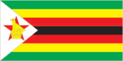
Flag description
seven equal horizontal bands of green, yellow, red, black, red, yellow, and green with a white isosceles triangle edged in black with its base on the hoist side; a yellow Zimbabwe bird is superimposed on a red five-pointed star in the center of the triangle
Government type
parliamentary democracy
Independence
18 April 1980 (from UK)
International organization participation
ACP, AfDB, C, CCC, ECA, FAO, G-15, G-77, IAEA, IBRD, ICAO, ICFTU, ICRM, IDA, IFAD, IFC, IFRCS, ILO, IMF, Intelsat, Interpol, IOC, IOM (observer), ISO, ITU, NAM, OAU, OPCW, PCA, SADC, UN, UNCTAD, UNESCO, UNIDO, UNMIK, UNTAET, UPU, WCL, WFTU, WHO, WIPO, WMO, WToO, WTrO
Judicial branch
Supreme Court
Legal system
mixture of Roman-Dutch and English common law
Legislative branch
- unicameral parliament, called House of Assembly (150 seats - 120 elected by popular vote for six-year terms, 12 nominated by the president, 10 occupied by traditional chiefs chosen by their peers, and 8 occupied by provincial governors)
- election results
- percent of vote by party - NA; seats by party - ZANU-PF 117, ZANU-NDONGA 2, independent 1
- elections
- last held 8-9 April 1995 (next to be held 24-25 June 2000)
National holiday
Independence Day, 18 April (1980)
Political parties and leaders
Democratic Party or DP [Emmanuel MAGOCHE]; Forum Party of Zimbabwe ; Movement for Democratic Change or MOC ; Popular Democratic Front or PDF ; United Parties ; Zimbabwe African National Union-NDONGA or ZANU-NDONGA [Ndabaningi SITHOLE]; Zimbabwe African National Union-Patriotic Front or ZANU-PF ; Zimbabwe Unity Movement or ZUM
Political pressure groups and leaders
National Constitutional Assembly or NCA
Suffrage
18 years of age; universal
Economy
Agriculture - products
corn, cotton, tobacco, wheat, coffee, sugarcane, peanuts; cattle, sheep, goats, pigs
Budget
- expenditures
- $2.9 billion, including capital expenditures of $279 million (FY96/97 est.)
- revenues
- $2.5 billion
Currency
1 Zimbabwean dollar (Z$) = 100 cents
Debt - external
$5 billion (1998)
Economic aid - recipient
$437.6 million (1995)
Economy - overview
The government of Zimbabwe faces a wide variety of difficult economic problems as it struggles to consolidate earlier progress in developing a market-oriented economy. Its involvement in the war in the Democratic Republic of the Congo, for example, has already drained hundreds of millions of dollars from the economy. Badly needed support from the IMF suffers delays in part because of the country's failure to meet budgetary goals. Inflation rose from an annual rate of 32% in 1998 to 59% in 1999. The economy is being steadily weakened by AIDS; Zimbabwe has the highest rate of infection in the world. Per capita GDP, which is twice the average of the poorer sub-Saharan nations, will increase little if any in the near-term, and Zimbabwe will suffer continued frustrations in developing its agricultural and mineral resources.
Electricity - consumption
8.403 billion kWh (1998)
Electricity - exports
0 kWh (1998)
Electricity - imports
1.921 billion kWh (1998)
Electricity - production
6.97 billion kWh (1998)
Electricity - production by source
- fossil fuel
- 78.19%
- hydro
- 21.81%
- nuclear
- 0%
- other
- 0% (1998)
Exchange rates
Zimbabwean dollars (Z$) per US$1 - 38.1679 (January 2000), 38.3142 (1999), 21.4133 (1998), 11.8906 (1997), 9.9206 (1996), 8.6580 (1995)
Exports
$2 billion (f.o.b., 1999 est.)
Exports - commodities
tobacco 23%, gold 14%, ferroalloys 7%, cotton 6% (1997 est.)
Exports - partners
South Africa 12%, UK 11%, Germany 8%, Japan 6%, US 6% (1997 est.)
Fiscal year
1 July - 30 June
GDP
purchasing power parity - $26.5 billion (1999 est.)
GDP - composition by sector
- agriculture
- 28%
- industry
- 32%
- services
- 40% (1997 est.)
GDP - per capita
purchasing power parity - $2,400 (1999 est.)
GDP - real growth rate
0% (1999 est.)
Household income or consumption by percentage share
lowest 10%: 1.8% highest 10%: 46.9% (1990)
Imports
$2 billion (f.o.b., 1998 est.)
Imports - commodities
machinery and transport equipment 39%, other manufactures 18%, chemicals 15%, fuels 10% (1997 est.)
Imports - partners
South Africa 37%, UK 7%, US 6%, Japan 6%, Germany 5% (1997 est.)
Industrial production growth rate
NA%
Industries
mining (coal, gold, copper, nickel, tin, clay, numerous metallic and nonmetallic ores), steel, wood products, cement, chemicals, fertilizer, clothing and footwear, foodstuffs, beverages
Inflation rate (consumer prices)
59% (1999 est.)
Labor force
5 million (1997 est.)
Labor force - by occupation
agriculture 66%, services 24%, industry 10% (1996 est.)
Population below poverty line
60% (1999 est.)
Unemployment rate
50% (1999 est.)
Communications
Internet Service Providers (ISPs)
10 (1999)
Radio broadcast stations
AM 7, FM 20 (plus 17 repeater stations), shortwave 1 (1998)
Radios
1.14 million (1997)
Telephone system
- system was once one of the best in Africa, but now suffers from poor maintenance; more than 100,000 outstanding requests for connection despite an equally large number of installed but unused main lines
- domestic
- consists of microwave radio relay links, open-wire lines, radiotelephone communication stations, fixed wireless local loop installations, and a substantial mobile cellular network; Internet connection is available in Harare and planned for all major towns and for some of the smaller ones
- international
- satellite earth stations - 2 Intelsat; two international digital gateway exchanges (in Harare and Gweru)
Telephones - main lines in use
212,000 (in addition there are about 20,000 fixed telephones in wireless local loop connections) (1997)
Telephones - mobile cellular
70,000 (1999)
Television broadcast stations
16 (1997)
Televisions
370,000 (1997)
Transportation
Airports
459 (1999 est.)
Airports - with paved runways
- total
- 18 over 3,047 m: 3 2,438 to 3,047 m: 2 1,524 to 2,437 m: 4 914 to 1,523 m: 9 (1999 est.)
Airports - with unpaved runways
- total
- 441 1,524 to 2,437 m: 4 914 to 1,523 m: 217 under 914 m: 220 (1999 est.)
Highways
- paved
- 8,692 km
- total
- 18,338 km
- unpaved
- 9,646 km (1996 est.)
Pipelines
petroleum products 212 km
Ports and harbors
Binga, Kariba
Railways
- narrow gauge
- 2,759 km 1.067-m gauge (313 km electrified; 42 km double track) (1995 est.)
- total
- 2,759 km (1995)
Waterways
the Mazoe and Zambezi rivers are used for transporting chrome ore from Harare to Mozambique
Military and Security
Military branches
Zimbabwe National Army, Air Force of Zimbabwe, Zimbabwe Republic Police (includes Police Support Unit, Paramilitary Police)
Military expenditures - dollar figure
$127 million (FY99/00)
Military expenditures - percent of GDP
3.1% (FY99/00)
Military manpower - availability
males age 15-49: 2,924,630 (2000 est.)
Military manpower - fit for military service
males age 15-49: 1,814,168 (2000 est.)
Transnational Issues
Illicit drugs
significant transit point for African cannabis and South Asian heroin, mandrax, and methamphetamines destined for the South African and European markets