1990 Edition
CIA World Factbook 1990 (Project Gutenberg)
Geography
Climate
tropical; moderated by altitude; rainy season (November to March)
Coastline
none--landlocked
Comparative area
slightly larger than Montana
Disputes
quadripoint with Botswana, Namibia, and Zambia is in disagreement
Environment
recurring droughts; floods and severe storms are rare; deforestation; soil erosion; air and water pollution; desertification
Land boundaries
3,066 km total; Botswana 813 km, Mozambique 1,231 km, South Africa 225 km, Zambia 797 km
Land use
7% arable land; NEGL% permanent crops; 12% meadows and pastures; 62% forest and woodland; 19% other; includes NEGL% irrigated
Maritime claims
none--landlocked
Natural resources
coal, chromium ore, asbestos, gold, nickel, copper, iron ore, vanadium, lithium, tin
Note
landlocked
Terrain
mostly high plateau with higher central plateau (high veld); mountains in east
Total area
390,580 km2; land area: 386,670 km2
People and Society
Birth rate
42 births/1,000 population (1990)
Death rate
9 deaths/1,000 population (1990)
Ethnic divisions
98% African (71% Shona, 16% Ndebele, 11% other); 1% white, 1% mixed and Asian
Infant mortality rate
65 deaths/1,000 live births (1990)
Labor force
3,100,000; 74% agriculture, 16% transport and services, 10% mining, manufacturing, construction (1987)
Language
English (official); Shona and Ndebele
Life expectancy at birth
59 years male, 63 years female (1990)
Literacy
74%
Nationality
noun--Zimbabwean(s); adjective--Zimbabwean
Net migration rate
0 migrants/1,000 population (1990)
Organized labor
17% of wage and salary earners have union membership
Population
10,392,161 (July 1990), growth rate 3.3% (1990)
Religion
50% syncretic (part Christian, part indigenous beliefs), 25% Christian, 24% indigenous beliefs, a few Muslim
Total fertility rate
5.8 children born/woman (1990)
Government
Administrative divisions
8 provinces; Manicaland, Mashonaland Central, Mashonaland East, Mashonaland West, Matabeleland North, Matabeleland South, Midlands, Victoria (commonly called Masvingo)
Capital
Harare
Communists
no Communist party
Constitution
21 December 1979
Diplomatic representation
Counselor (Political Affairs), Head of Chancery, Ambassador Stanislaus Garikai CHIGWEDERE; Chancery at 2852 McGill Terrace NW, Washington DC 20008; telephone (202) 332-7100; US--Ambassador-designate Steven RHODES; Embassy at 172 Rhodes Avenue, Harare (mailing address is P. O. Box 3340, Harare); telephone 263o (14) 794-521
Elections
President--last held 28-30 March 1990 (next to be held March 1995); results--President Robert Mugabe 78.3%; Edgar Tekere 21.7%; Parliament--last held 28-30 March 1990 (next to be held March 1993); results--percent of vote by party NA; seats--(150 total, 120 elected) ZANU 116, ZUM 2, ZANU-S 1, to be determined 1
Executive branch
president, vice president, Cabinet
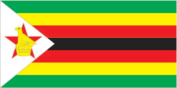
Flag
seven equal horizontal bands of green, yellow, red, black, red, yellow, and green with a white equilateral triangle edged in black based on the hoist side; a yellow Zimbabwe bird is superimposed on a red five-pointed star in the center of the triangle
Independence
18 April 1980 (from UK; formerly Southern Rhodesia)
Judicial branch
Supreme Court
Leaders
Chief of State and Head of Government--Executive President Robert Gabriel MUGABE (since 31 December 1987); Vice President Simon Vengai MUZENDA (since 31 December 1987)
Legal system
mixture of Roman-Dutch and English common law
Legislative branch
unicameral Parliament
Long-form name
Republic of Zimbabwe
Member of
ACP, AfDB, CCC, Commonwealth, FAO, G-77, GATT, IAEA, IBRD, ICAO, IDA, IFAD, IFC, ILO, IMF, INTERPOL, NAM, OAU, SADCC, UN, UNESCO, UPU, WFTU, WHO, WMO
National holiday
Independence Day, 18 April (1980)
Political parties and leaders
Zimbabwe African National Union-Patriotic Front (ZANU-PF), Robert Mugabe; Zimbabwe African National Union-Sithole (ZANU-S), Ndabaningi Sithole; Zimbabwe Unity Movement (ZUM), Edgar Tekere
Suffrage
universal at age 18
Type
parliamentary democracy
Economy
Agriculture
accounts for about 15% of GDP and employs over 70% of population; 40% of land area divided into 6,000 large commercial farms and 42% in communal lands; crops--corn (food staple), cotton, tobacco, wheat, coffee, sugarcane, peanuts; livestock--cattle, sheep, goats, pigs; self-sufficient in food
Aid
US commitments, including Ex-Im (FY80-88), $359 million; Western (non-US) countries, ODA and OOF bilateral commitments (1970-87), $2.0 billion; OPEC bilateral aid (1979-89), $36 million; Communist countries (1970-88), $134 million
Budget
revenues $2.4 billion; expenditures $3.0 billion, including capital expenditures of $290 million (FY90)
Currency
Zimbabwean dollar (plural--dollars); 1 Zimbabwean dollar (Z$) = 100 cents
Electricity
2,036,000 kW capacity; 5,460 million kWh produced, 540 kWh per capita (1989)
Exchange rates
Zimbabwean dollars (Z$) per US$1--2.2873 (January 1990), 2.1133 (1989), 1.8018 (1988), 1.6611 (1987), 1.6650 (1986), 1.6119 (1985)
Exports
$1.6 billion (f.o.b., 1988); commodities--agricultural 34% (tobacco 21%, other 13%), manufactures 19%, gold 11%, ferrochrome 11%, cotton 6%; partners--Europe 55% (EC 41%, Netherlands 6%, other 8%), Africa 22% (South Africa 12%, other 10%), US 6%
External debt
$2.96 billion (December 1989 est.)
Fiscal year
1 July-30 June
GDP
$4.6 billion, per capita $470; real growth rate 5.3% (1988 est.)
Imports
$1.1 billion (c.i.f., 1988); commodities--machinery and transportation equipment 37%, other manufactures 22%, chemicals 16%, fuels 15%; partners--EC 31%, Africa 29% (South Africa 21%, other 8%), US 8%, Japan 4%
Industrial production
growth rate 4.7% (1988 est.)
Industries
mining, steel, clothing and footwear, chemicals, foodstuffs, fertilizer, beverage, transportation equipment, wood products
Inflation rate (consumer prices)
7.4% (1988)
Overview
Agriculture employs a majority of the labor force and supplies almost 40% of exports. The agro-based manufacturing sector produces a variety of goods and contributes about 25% to GDP. Mining accounts for only 5% of both GDP and employment, but supplies of minerals and metals account for about 40% of exports. Wide year-to-year fluctuations in agricultural production over the past six years resulted in not only an uneven growth rate, but one that did not equal the 3% annual increase in population.
Unemployment rate
at least 20% (1988 est.)
Communications
Airports
506 total, 420 usable; 23 with permanent-surface runways; 2 with runways over 3,659 m; 3 with runways 2,440-3,659 m; 37 with runways 1,220-2,439 m
Civil air
12 major transport aircraft
Highways
85,237 km total; 15,800 km paved, 39,090 km crushed stone, gravel, stabilized soil: 23,097 km improved earth; 7,250 km unimproved earth
Inland waterways
Lake Kariba is a potential line of communication
Pipelines
8 km, refined products
Railroads
2,745 km 1.067-meter gauge; 42 km double track; 355 km electrified
Telecommunications
system was once one of the best in Africa, but now suffers from poor maintenance; consists of radio relay links, open-wire lines, and radio communications stations; 247,000 telephones; stations--8 AM, 18 FM, 8 TV; 1 Atlantic Ocean INTELSAT earth station
Military and Security
Branches
Zimbabwe National Army, Air Force of Zimbabwe, Police Support Unit, People's Militia
Defense expenditures
$446.7 million (FY89 est.)
Military manpower
males 15-49, 2,173,448; 1,342,920 fit for military service