1996 Edition
CIA World Factbook 1996 (Project Gutenberg)
Countries
256
Data Records
32,906
Categories
7
Source
CIA World Factbook 1996 (Project Gutenberg)
Introduction
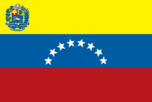
Description
three equal horizontal bands of yellow (top), blue, and red with the coat of arms on the hoist side of the yellow band and an arc of seven white five-pointed stars centered in the blue band
Location
8 00 N, 66 00 W -- Northern South America, bordering the Caribbean Sea and the North Atlantic Ocean, between Colombia and Guyana Flag ----
Geography
Area
- comparative area
- slightly more than twice the size of California
- land area
- 882,050 sq km
- total area
- 912,050 sq km
Coastline
2,800 km
Geographic coordinates
8 00 N, 66 00 W
International disputes
claims all of Guyana west of the Essequibo River; maritime boundary dispute with Colombia in the Gulf of
Land boundaries
- border countries
- Brazil 2,200 km, Colombia 2,050 km, Guyana 743 km
- total
- 4,993 km
Location
Northern South America, bordering the Caribbean Sea and the North Atlantic Ocean, between Colombia and Guyana
Map references
South America
Maritime claims
- contiguous zone
- 15 nm
- continental shelf
- 200-m depth or to the depth of exploitation
- exclusive economic zone
- 200 nm
- territorial sea
- 12 nm