2017 Edition
CIA World Factbook 2017 Archive (HTML)
Introduction
Background
Multiple waves of colonizers, each speaking a distinct language, migrated to the New Hebrides in the millennia preceding European exploration in the 18th century. This settlement pattern accounts for the complex linguistic diversity found on the archipelago to this day. The British and French, who settled the New Hebrides in the 19th century, agreed in 1906 to an Anglo-French Condominium, which administered the islands until independence in 1980, when the new name of Vanuatu was adopted.
Geography
Area
- 12,189 sq km 12,189 sq km 0 sq km includes more than 80 islands, about 65 of which are inhabited
- land
- 12,189 sq km
- note
- includes more than 80 islands, about 65 of which are inhabited
- total
- 12,189 sq km
- water
- 0 sq km
Area - comparative
slightly larger than Connecticut
Climate
tropical; moderated by southeast trade winds from May to October; moderate rainfall from November to April; may be affected by cyclones from December to April
Coastline
2,528 km
Elevation
- NA lowest point: Pacific Ocean 0 m highest point: Tabwemasana 1,877 m
- elevation extremes
- lowest point: Pacific Ocean 0 m
- highest point
- Tabwemasana 1,877 m
- mean elevation
- NA
Environment - current issues
most of the population does not have access to a reliable supply of potable water; deforestation
Environment - international agreements
- Antarctic-Marine Living Resources, Biodiversity, Climate Change, Climate Change-Kyoto Protocol, Desertification, Endangered Species, Law of the Sea, Marine Dumping, Ozone Layer Protection, Ship Pollution, Tropical Timber 94 none of the selected agreements
- party to
- Antarctic-Marine Living Resources, Biodiversity, Climate Change, Climate Change-Kyoto Protocol, Desertification, Endangered Species, Law of the Sea, Marine Dumping, Ozone Layer Protection, Ship Pollution, Tropical Timber 94
- signed, but not ratified
- none of the selected agreements
Geographic coordinates
16 00 S, 167 00 E
Geography - note
a Y-shaped chain of four main islands and 80 smaller islands; several of the islands have active volcanoes and there are several underwater volcanoes as well
Irrigated land
0 sq km (2012)
Land boundaries
0 km
Land use
- 15.3% arable land 1.6%; permanent crops 10.3%; permanent pasture 3.4% 36.1% 48.6% (2011 est.)
- agricultural land
- 15.3%
- forest
- 36.1%
- other
- 48.6% (2011 est.)
Location
Oceania, group of islands in the South Pacific Ocean, about three-quarters of the way from Hawaii to Australia
Map references
Oceania
Maritime claims
- measured from claimed archipelagic baselines 12 nm 24 nm 200 nm 200 nm or to the edge of the continental margin
- contiguous zone
- 24 nm
- continental shelf
- 200 nm or to the edge of the continental margin
- exclusive economic zone
- 200 nm
- territorial sea
- 12 nm
Natural hazards
- tropical cyclones (January to April); volcanic eruption on Aoba (Ambae) island began on 27 November 2005, volcanism also causes minor earthquakes; tsunamis significant volcanic activity with multiple eruptions in recent years; Yasur (361 m), one of the world's most active volcanoes, has experienced continuous activity in recent centuries; other historically active volcanoes include, Aoba, Ambrym, Epi, Gaua, Kuwae, Lopevi, Suretamatai, and Traitor's Head
- volcanism
- significant volcanic activity with multiple eruptions in recent years; Yasur (361 m), one of the world's most active volcanoes, has experienced continuous activity in recent centuries; other historically active volcanoes include, Aoba, Ambrym, Epi, Gaua, Kuwae, Lopevi, Suretamatai, and Traitor's Head
Natural resources
manganese, hardwood forests, fish
Population - distribution
three-quarters of the population lives in rural areas; the urban populace lives primarily in two cities, Port-Vila and Lugenville; three largest islands - Espiritu Santo, Malakula, and Efate - accomodate over half of the populace
Terrain
mostly mountainous islands of volcanic origin; narrow coastal plains
People and Society
Age structure
- 35.51% (male 51,261/female 49,157) 20.02% (male 28,110/female 28,514) 35.06% (male 48,476/female 50,675) 5.42% (male 7,646/female 7,677) 3.99% (male 5,713/female 5,585) (2017 est.)
- 0-14 years
- 35.51% (male 51,261/female 49,157)
- 15-24 years
- 20.02% (male 28,110/female 28,514)
- 25-54 years
- 35.06% (male 48,476/female 50,675)
- 55-64 years
- 5.42% (male 7,646/female 7,677)
- 65 years and over
- 3.99% (male 5,713/female 5,585) (2017 est.)
Birth rate
24 births/1,000 population (2017 est.)
Children under the age of 5 years underweight
10.7% (2013)
Contraceptive prevalence rate
49% (2013)
Death rate
4 deaths/1,000 population (2017 est.)
Dependency ratios
- 68.7 61.6 7.1 14.1 (2015 est.)
- elderly dependency ratio
- 7.1
- potential support ratio
- 14.1 (2015 est.)
- total dependency ratio
- 68.7
- youth dependency ratio
- 61.6
Drinking water source
- urban: 98.9% of population rural: 92.9% of population total: 94.5% of population urban: 1.1% of population rural: 7.1% of population total: 5.5% of population (2015 est.)
- rural
- 7.1% of population
- total
- 5.5% of population (2015 est.)
- urban
- 1.1% of population
Education expenditures
4.9% of GDP (2014)
Ethnic groups
Ni-Vanuatu 97.6%, part Ni-Vanuatu 1.1%, other 1.3% (2009 est.)
Health expenditures
5% of GDP (2014)
HIV/AIDS - adult prevalence rate
NA
HIV/AIDS - deaths
NA
HIV/AIDS - people living with HIV/AIDS
NA
Hospital bed density
1.8 beds/1,000 population (2008)
Infant mortality rate
- 14.4 deaths/1,000 live births 15.4 deaths/1,000 live births 13.4 deaths/1,000 live births (2017 est.)
- female
- 13.4 deaths/1,000 live births (2017 est.)
- male
- 15.4 deaths/1,000 live births
- total
- 14.4 deaths/1,000 live births
Languages
local languages (more than 100) 63.2%, Bislama (official; creole) 33.7%, English (official) 2%, French (official) 0.6%, other 0.5% (2009 est.)
Life expectancy at birth
- 73.7 years 72.1 years 75.4 years (2017 est.)
- female
- 75.4 years (2017 est.)
- male
- 72.1 years
- total population
- 73.7 years
Literacy
- age 15 and over can read and write 85.2% 86.6% 83.8% (2015 est.)
- definition
- age 15 and over can read and write
- female
- 83.8% (2015 est.)
- male
- 86.6%
- total population
- 85.2%
Major urban areas - population
PORT-VILA (capital) 53,000 (2014)
Maternal mortality rate
78 deaths/100,000 live births (2015 est.)
Median age
- 22 years 21.6 years 22.4 years (2017 est.)
- female
- 22.4 years (2017 est.)
- male
- 21.6 years
- total
- 22 years
Nationality
- Ni-Vanuatu (singular and plural) Ni-Vanuatu
- adjective
- Ni-Vanuatu
- noun
- Ni-Vanuatu (singular and plural)
Net migration rate
-1.4 migrant(s)/1,000 population (2017 est.)
Obesity - adult prevalence rate
25.2% (2016)
Physicians density
0.19 physicians/1,000 population (2012)
Population
282,814 (July 2017 est.)
Population distribution
three-quarters of the population lives in rural areas; the urban populace lives primarily in two cities, Port-Vila and Lugenville; three largest islands - Espiritu Santo, Malakula, and Efate - accomodate over half of the populace
Population growth rate
1.85% (2017 est.)
Religions
Protestant 70% (includes Presbyterian 27.9%, Anglican 15.1%, Seventh Day Adventist 12.5%, Assemblies of God 4.7%, Church of Christ 4.5%, Neil Thomas Ministry 3.1%, and Apostolic 2.2%), Roman Catholic 12.4%, customary beliefs 3.7% (including Jon Frum cargo cult), other 12.6%, none 1.1%, unspecified 0.2% (2009 est.)
Sanitation facility access
- urban: 65.1% of population rural: 55.4% of population total: 57.9% of population urban: 34.9% of population rural: 44.6% of population total: 42.1% of population (2015 est.)
- rural
- 44.6% of population
- total
- 42.1% of population (2015 est.)
- urban
- 34.9% of population
Sex ratio
- 1.05 male(s)/female 1.04 male(s)/female 0.99 male(s)/female 0.96 male(s)/female 1 male(s)/female 1.04 male(s)/female 1 male(s)/female (2016 est.)
- 0-14 years
- 1.04 male(s)/female
- 15-24 years
- 0.99 male(s)/female
- 25-54 years
- 0.96 male(s)/female
- 55-64 years
- 1 male(s)/female
- 65 years and over
- 1.04 male(s)/female
- at birth
- 1.05 male(s)/female
- total population
- 1 male(s)/female (2016 est.)
Total fertility rate
3.07 children born/woman (2017 est.)
Unemployment, youth ages 15-24
- 10.6% 10.2% 11.2% (2009 est.)
- female
- 11.2% (2009 est.)
- male
- 10.2%
- total
- 10.6%
Urbanization
- 26.8% of total population (2017) 3.23% annual rate of change (2015-20 est.)
- rate of urbanization
- 3.23% annual rate of change (2015-20 est.)
- urban population
- 26.8% of total population (2017)
Government
Administrative divisions
6 provinces; Malampa, Penama, Sanma, Shefa, Tafea, Torba
Capital
- Port-Vila (on Efate) 17 44 S, 168 19 E UTC+11 (16 hours ahead of Washington, DC, during Standard Time)
- geographic coordinates
- 17 44 S, 168 19 E
- name
- Port-Vila (on Efate)
- time difference
- UTC+11 (16 hours ahead of Washington, DC, during Standard Time)
Citizenship
- no both parents must be citizens of Vanuatu; in the case of only one parent, it must be the father who is a citizen no 10 years
- citizenship by birth
- no
- citizenship by descent only
- both parents must be citizens of Vanuatu; in the case of only one parent, it must be the father who is a citizen
- dual citizenship recognized
- no
- residency requirement for naturalization
- 10 years
Constitution
effective 30 July 1980; amended several times, last in 2013 (2016)
Country name
- Republic of Vanuatu Vanuatu Ripablik blong Vanuatu Vanuatu New Hebrides derived from the words "vanua" (home or land) and "tu" (stand) that occur in several of the Austonesian languages spoken on the islands and which provide a meaning of "the land remains" but which also convey a sense of "independence" or "our land"
- conventional long form
- Republic of Vanuatu
- conventional short form
- Vanuatu
- etymology
- derived from the words "vanua" (home or land) and "tu" (stand) that occur in several of the Austonesian languages spoken on the islands and which provide a meaning of "the land remains" but which also convey a sense of "independence" or "our land"
- former
- New Hebrides
- local long form
- Ripablik blong Vanuatu
- local short form
- Vanuatu
Diplomatic representation from the US
the US does not have an embassy in Vanuatu; the US Ambassador to Papua New Guinea is accredited to Vanuatu
Diplomatic representation in the US
Vanuatu does not have an embassy in the US; it does, however, have a Permanent Mission to the UN
Executive branch
- President Tallis Obed MOSES (since 6 July 2017) Prime Minister Charlot SALWAI (since 11 February 2016) Council of Ministers appointed by the prime minister, responsible to parliament president indirectly elected by an electoral college consisting of Parliament and presidents of the 6 provinces; Vanuatu president serves a 5-year term; election last held on 17 September 2014 (next to be held in 2019); following legislative elections, the leader of the majority party or majority coalition usually elected prime minister by parliament from among its members; election for prime minister last held on 11 February 2016 (next to be held following general elections in 2020) Baldwin LONSDALE (independent) died suddenly on 17 June 2017; Parliament elected Tallis Obed MOSES on 6 July 2017 with a 39 to 17 vote in the fourth round; Charlot SALWAI elected prime minister on 11 February 2016 with 46 votes
- cabinet
- Council of Ministers appointed by the prime minister, responsible to parliament
- chief of state
- President Tallis Obed MOSES (since 6 July 2017)
- election results
- Baldwin LONSDALE (independent) died suddenly on 17 June 2017; Parliament elected Tallis Obed MOSES on 6 July 2017 with a 39 to 17 vote in the fourth round; Charlot SALWAI elected prime minister on 11 February 2016 with 46 votes
- elections/appointments
- president indirectly elected by an electoral college consisting of Parliament and presidents of the 6 provinces; Vanuatu president serves a 5-year term; election last held on 17 September 2014 (next to be held in 2019); following legislative elections, the leader of the majority party or majority coalition usually elected prime minister by parliament from among its members; election for prime minister last held on 11 February 2016 (next to be held following general elections in 2020)
- head of government
- Prime Minister Charlot SALWAI (since 11 February 2016)
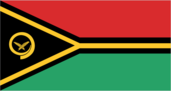
Flag description
- two equal horizontal bands of red (top) and green with a black isosceles triangle (based on the hoist side) all separated by a black-edged yellow stripe in the shape of a horizontal Y (the two points of the Y face the hoist side and enclose the triangle); centered in the triangle is a boar's tusk encircling two crossed namele fern fronds, all in yellow; red represents the blood of boars and men, as well as unity, green the richness of the islands, and black the ni-Vanuatu people; the yellow Y-shape - which reflects the pattern of the islands in the Pacific Ocean - symbolizes the light of the Gospel spreading through the islands; the boar's tusk is a symbol of prosperity frequently worn as a pendant on the islands; the fern fronds represent peace one of several flags where a prominent component of the design reflects the shape of the country; other such flags are those of Bosnia and Herzegovina, Brazil, and Eritrea
- note
- one of several flags where a prominent component of the design reflects the shape of the country; other such flags are those of Bosnia and Herzegovina, Brazil, and Eritrea
Government type
parliamentary republic
Independence
30 July 1980 (from France and the UK)
International law organization participation
has not submitted an ICJ jurisdiction declaration; accepts ICCt jurisdiction
International organization participation
ACP, ADB, AOSIS, C, FAO, G-77, IBRD, ICAO, ICRM, IDA, IFC, IFRCS, ILO, IMF, IMO, IMSO, IOC, IOM, ITU, ITUC (NGOs), MIGA, NAM, OAS (observer), OIF, OPCW, PIF, Sparteca, SPC, UN, UNCTAD, UNESCO, UNIDO, UNWTO, UPU, WCO, WFTU (NGOs), WHO, WIPO, WMO, WTO
Judicial branch
- Court of Appeal (consists of 2 or more judges of the Supreme Court designated by the chief justice); Supreme Court (consists of the chief justice and 6 puisne judges - 3 local and 3 expatriate) Supreme Court chief justice appointed by the president after consultation with the prime minister and the leader of the opposition; other judges are appointed by the president on the advice of the Judicial Service Commission, a 4-member advisory body; judges appointed until age of retirement Magistrates Courts; Island Courts
- highest court(s)
- Court of Appeal (consists of 2 or more judges of the Supreme Court designated by the chief justice); Supreme Court (consists of the chief justice and 6 puisne judges - 3 local and 3 expatriate)
- judge selection and term of office
- Supreme Court chief justice appointed by the president after consultation with the prime minister and the leader of the opposition; other judges are appointed by the president on the advice of the Judicial Service Commission, a 4-member advisory body; judges appointed until age of retirement
- subordinate courts
- Magistrates Courts; Island Courts
Legal system
mixed legal system of English common law, French law, and customary law
Legislative branch
- unicameral Parliament (52 seats; members directly elected in multi-seat constituencies by simple majority vote to serve 4-year terms) the National Council of Chiefs advises on matters of culture and language last held on 22 January 2016 (next to be held in 2020) percent of vote by party - NA; seats by party - VP 8, PPP 6, UMP 5, GJP 4, NUP 4, IG 3, GC 3, NAG 3, RMC 3, MPP 2, NIPDP 2, PSP 1, VLDP 1, VNP 1, VPDP 1, VRP 1, and independent 4; note - political party associations are fluid
- description
- unicameral Parliament (52 seats; members directly elected in multi-seat constituencies by simple majority vote to serve 4-year terms)
- election results
- percent of vote by party - NA; seats by party - VP 8, PPP 6, UMP 5, GJP 4, NUP 4, IG 3, GC 3, NAG 3, RMC 3, MPP 2, NIPDP 2, PSP 1, VLDP 1, VNP 1, VPDP 1, VRP 1, and independent 4; note - political party associations are fluid
- elections
- last held on 22 January 2016 (next to be held in 2020)
- note
- the National Council of Chiefs advises on matters of culture and language
National anthem
- "Yumi, Yumi, Yumi" (We, We, We) Francois Vincent AYSSAV adopted 1980; the anthem is written in Bislama, a Creole language that mixes Pidgin English and French
- lyrics/music
- Francois Vincent AYSSAV
- name
- "Yumi, Yumi, Yumi" (We, We, We)
- note
- adopted 1980; the anthem is written in Bislama, a Creole language that mixes Pidgin English and French
National holiday
Independence Day, 30 July (1980)
National symbol(s)
- boar's tusk with crossed fern fronds; national colors: red, black, green, yellow
- boar's tusk with crossed fern fronds; national colors
- red, black, green, yellow
Political parties and leaders
Greens Confederation or GC [Moana CARCASSES Kalosil] Iauko Group or IG [Tony NARI] Land and Justice Party (Graon mo Jastis Pati) or GJP [Ralph REGENVANU] Melanesian Progressive Party or MPP [Barak SOPE] Nagriamel movement or NAG [Frankie STEVENS] Natatok Indigenous People's Democratic Party or (NATATOK) or NIPDP [Alfred Roland CARLOT] National United Party or NUP [Ham LINI] People's Progressive Party or PPP [Sato KILMAN] People's Service Party or PSP [Don KEN] Reunification of Movement for Change or RMC [Charlot SALWAI] Union of Moderate Parties or UMP [Serge VOHOR] Vanua'aku Pati (Our Land Party) or VP [Edward NATAPEI] Vanuatu Democratic Party [Maxime Carlot KORMAN] Vanuatu Liberal Democratic Party or VLDP [Tapangararua WILLIE] Vanuatu National Party or VNP [Issac HAMARILIU] Vanuatu National Development Party or VNDP [Robert Bohn SIKOL] Vanuatu Republican Party or VRP [Marcellino PIPITE]
Political pressure groups and leaders
NA
Suffrage
18 years of age; universal
Economy
Agriculture - products
copra, coconuts, cocoa, coffee, taro, yams, fruits, vegetables; beef; fish
Budget
- $205.6 million $201 million (2016 est.)
- expenditures
- $201 million (2016 est.)
- revenues
- $205.6 million
Budget surplus (+) or deficit (-)
0.6% of GDP (2016 est.)
Central bank discount rate
20% (31 December 2010) 6% (31 December 2009)
Commercial bank prime lending rate
2.95% (31 December 2016 est.) 3.63% (31 December 2015 est.)
Current account balance
$-30 million (2016 est.) $-82.1 million (2015 est.)
Debt - external
$182.5 million (31 December 2016 est.) $170.2 million (31 December 2015 est.)
Economy - overview
This South Pacific island economy is based primarily on small-scale agriculture, which provides a living for about two-thirds of the population. Fishing, offshore financial services, and tourism, with nearly 350,000 visitors in 2016, are other mainstays of the economy. Tourism has struggled after Efate, the most populous and popular island for tourists, was damaged by Tropical Cyclone Pam in 2015. Ongoing infrastructure difficulties at Port Vila’s Bauerfield Airport have caused air travel disruptions, further hampering tourism numbers. Australia and New Zealand are the main source of tourists and foreign aid. A small light industry sector caters to the local market. Tax revenues come mainly from import duties. Mineral deposits are negligible; the country has no known petroleum deposits. Economic development is hindered by dependence on relatively few commodity exports, vulnerability to natural disasters, and long distances from main markets and between constituent islands. In response to foreign concerns, the government has promised to tighten regulation of its offshore financial center. Since 2002, the government has stepped up efforts to boost tourism through improved air connections, resort development, and cruise ship facilities. Agriculture, especially livestock farming, is a second target for growth.
Exchange rates
vatu (VUV) per US dollar - 108.48 (2016 est.) 108.48 (2015 est.) 108.99 (2014 est.) 97.07 (2013 est.) 92.64 (2012 est.)
Exports
$53.5 million (2016 est.) $38.8 million (2015 est.)
Exports - commodities
copra, beef, cocoa, timber, kava, coffee
Exports - partners
Ecuador 18.4%, Australia 13.8%, Venezuela 10.1%, US 9.8%, Japan 8.2%, UK 6.7%, France 5.7%, Hong Kong 5.2% (2016)
Fiscal year
calendar year
GDP - composition, by end use
- 59.7% 17.6% 29% 1% 40.7% -48% (2016 est.)
- exports of goods and services
- 40.7%
- government consumption
- 17.6%
- household consumption
- 59.7%
- imports of goods and services
- -48% (2016 est.)
- investment in fixed capital
- 29%
- investment in inventories
- 1%
GDP - composition, by sector of origin
- 26.9% 9% 64.2% (2016 est.)
- agriculture
- 26.9%
- industry
- 9%
- services
- 64.2% (2016 est.)
GDP - per capita (PPP)
- $2,700 (2016 est.) $2,600 (2015 est.) $2,700 (2014 est.) data are in 2016 dollars
- note
- data are in 2016 dollars
GDP - real growth rate
4% (2016 est.) 1.6% (2015 est.) 2.3% (2014 est.)
GDP (official exchange rate)
$807 million (2016 est.)
GDP (purchasing power parity)
- $740 million (2016 est.) $703 million (2015 est.) $684 million (2014 est.) data are in 2016 dollars
- note
- data are in 2016 dollars
Household income or consumption by percentage share
- NA% NA%
- highest 10%
- NA%
- lowest 10%
- NA%
Imports
$308.5 million (2016 est.) $307.9 million (2015 est.)
Imports - commodities
machinery and equipment, foodstuffs, fuels
Imports - partners
Australia 27.8%, NZ 17.6%, China 10.5%, France 10%, Singapore 6.1%, Thailand 4.8% (2016)
Industrial production growth rate
4% (2016 est.)
Industries
food and fish freezing, wood processing, meat canning
Inflation rate (consumer prices)
0.9% (2016 est.) 2.4% (2015 est.)
Labor force
115,900 (2007 est.)
Labor force - by occupation
- 65% 5% 30% (2000 est.)
- agriculture
- 65%
- industry
- 5%
- services
- 30% (2000 est.)
Market value of publicly traded shares
$NA
Population below poverty line
NA%
Public debt
31.3% of GDP (2016 est.) 25.6% of GDP (2015 est.)
Reserves of foreign exchange and gold
$267.4 million (31 December 2016 est.) $269.2 million (31 December 2015 est.)
Stock of broad money
$641 million (31 December 2016 est.) $588.7 million (31 December 2015 est.)
Stock of direct foreign investment - abroad
$22.4 million (31 December 2016 est.) $22.6 million (31 December 2015 est.)
Stock of direct foreign investment - at home
$535.9 million (31 December 2016 est.) $500.9 million (31 December 2015 est.)
Stock of domestic credit
$463.4 million (31 December 2016 est.) $477 million (31 December 2015 est.)
Stock of narrow money
$379.9 million (31 December 2016 est.) $320.9 million (31 December 2015 est.)
Taxes and other revenues
26.6% of GDP (2016 est.)
Unemployment rate
1.7% (1999 est.)
Energy
Carbon dioxide emissions from consumption of energy
200,000 Mt (2013 est.)
Crude oil - exports
0 bbl/day (2014 est.)
Crude oil - imports
0 bbl/day (2014 est.)
Crude oil - production
0 bbl/day (2016 est.)
Crude oil - proved reserves
0 bbl (1 January 2017 es)
Electricity - consumption
51.15 million kWh (2015 est.)
Electricity - exports
0 kWh (2016 est.)
Electricity - from fossil fuels
81.8% of total installed capacity (2015 est.)
Electricity - from hydroelectric plants
0% of total installed capacity (2015 est.)
Electricity - from nuclear fuels
0% of total installed capacity (2015 est.)
Electricity - from other renewable sources
18.2% of total installed capacity (2015 est.)
Electricity - imports
0 kWh (2016 est.)
Electricity - installed generating capacity
33,000 kW (2015 est.)
Electricity - production
55 million kWh (2015 est.)
Electricity access
- 202,614 27% 55% 18% (2012)
- electrification - rural areas
- 18% (2012)
- electrification - total population
- 27%
- electrification - urban areas
- 55%
- population without electricity
- 202,614
Natural gas - consumption
0 cu m (2013 est.)
Natural gas - exports
0 cu m (2013 est.)
Natural gas - imports
0 cu m (2013 est.)
Natural gas - production
0 cu m (2013 est.)
Natural gas - proved reserves
0 cu m (1 January 2014 es)
Refined petroleum products - consumption
1,000 bbl/day (2015 est.)
Refined petroleum products - exports
0 bbl/day (2014 est.)
Refined petroleum products - imports
1,008 bbl/day (2014 est.)
Refined petroleum products - production
0 bbl/day (2014 est.)
Communications
Broadcast media
1 state-owned TV station; multi-channel pay TV is available; state-owned Radio Vanuatu operates 2 radio stations; 2 privately owned radio broadcasters; programming from multiple international broadcasters is available (2008)
Internet country code
.vu
Internet users
- 66,613 24.0% (July 2016 est.)
- percent of population
- 24.0% (July 2016 est.)
- total
- 66,613
Telephone system
- telecom services have progressed significantly in recent years; mobile phones are now the primary means of communication and more than 90% of the population is covered by a mobile network 2016 saw the launch of LTE services by Digicel and the introduction of rural satellite broadband services by Kacific; mobile phone use in some rural areas is constrained by electricity shortages country code - 678; satellite earth station - 1 Intelsat (Pacific Ocean) (2016)
- domestic
- 2016 saw the launch of LTE services by Digicel and the introduction of rural satellite broadband services by Kacific; mobile phone use in some rural areas is constrained by electricity shortages
- general assessment
- telecom services have progressed significantly in recent years; mobile phones are now the primary means of communication and more than 90% of the population is covered by a mobile network
- international
- country code - 678; satellite earth station - 1 Intelsat (Pacific Ocean) (2016)
Telephones - fixed lines
- 4,267 2 (July 2016 est.)
- subscriptions per 100 inhabitants
- 2 (July 2016 est.)
- total subscriptions
- 4,267
Telephones - mobile cellular
- 192,167 69 (July 2016 est.)
- subscriptions per 100 inhabitants
- 69 (July 2016 est.)
- total
- 192,167
Transportation
Airports
31 (2013)
Airports - with paved runways
- 1 (2013)
- 1,524 to 2,437 m
- 1
- 2,438 to 3,047 m
- 1
- 914 to 1,523 m
- 1 (2013)
- total
- 3
Airports - with unpaved runways
- 21 (2013)
- 914 to 1,523 m
- 7
- total
- 28
- under 914 m
- 21 (2013)
Civil aircraft registration country code prefix
YJ (2016)
Merchant marine
- bulk carrier 38, cargo 8, chemical tanker 2, container 1, liquefied gas 2, passenger 1, refrigerated cargo 24, vehicle carrier 1 72 (Belgium 1, Canada 5, China 1, Greece 3, Japan 39, Norway 1, Poland 9, Russia 7, Singapore 2, Taiwan 1, UAE 1, US 2) (2010)
- by type
- bulk carrier 38, cargo 8, chemical tanker 2, container 1, liquefied gas 2, passenger 1, refrigerated cargo 24, vehicle carrier 1
- foreign-owned
- 72 (Belgium 1, Canada 5, China 1, Greece 3, Japan 39, Norway 1, Poland 9, Russia 7, Singapore 2, Taiwan 1, UAE 1, US 2) (2010)
- total
- 77
National air transport system
- 287,526 1,510,732 mt-km (2015)
- annual freight traffic on registered air carriers
- 1,510,732 mt-km (2015)
- annual passenger traffic on registered air carriers
- 287,526
- inventory of registered aircraft operated by air carriers
- 6
- number of registered air carriers
- 1
Ports and terminals
- Forari Bay, Luganville (Santo, Espiritu Santo), Port-Vila
- major seaport(s)
- Forari Bay, Luganville (Santo, Espiritu Santo), Port-Vila
Roadways
- 1,070 km 256 km 814 km (2000)
- paved
- 256 km
- total
- 1,070 km
- unpaved
- 814 km (2000)
Military and Security
Military branches
no regular military forces; Vanuatu Police Force (VPF), Vanuatu Mobile Force (VMF; includes Police Maritime Wing (PMW)) (2013)
Transnational Issues
Disputes - international
Matthew and Hunter Islands east of New Caledonia claimed by Vanuatu and France