2017 Edition
CIA World Factbook 2017 Archive (HTML)
Introduction
Background
The Danes secured control over the southern Virgin Islands of Saint Thomas, Saint John, and Saint Croix during the 17th and early 18th centuries. Sugarcane, produced by African slave labor, drove the islands' economy during the 18th and early 19th centuries. In 1917, the US purchased the Danish holdings, which had been in economic decline since the abolition of slavery in 1848. On 6 September 2017, Hurricane Irma passed over the northern Virgin Islands of Saint Thomas and Saint John and inflicted severe damage to structures, roads, the airport on Saint Thomas, communications, and electricity. Less than two weeks later, Hurricane Maria passed over the island of Saint Croix in the southern Virgin Islands inflicting considerable damage with heavy winds and flooding rains.
Geography
Area
- 1,910 sq km 346 sq km 1,564 sq km
- land
- 346 sq km
- total
- 1,910 sq km
- water
- 1,564 sq km
Area - comparative
twice the size of Washington, DC
Climate
subtropical, tempered by easterly trade winds, relatively low humidity, little seasonal temperature variation; rainy season September to November
Coastline
188 km
Elevation
- NA lowest point: Caribbean Sea 0 m highest point: Crown Mountain 474 m
- elevation extremes
- lowest point: Caribbean Sea 0 m
- highest point
- Crown Mountain 474 m
- mean elevation
- NA
Environment - current issues
lack of natural freshwater resources
Geographic coordinates
18 20 N, 64 50 W
Geography - note
important location along the Anegada Passage - a key shipping lane for the Panama Canal; Saint Thomas has one of the best natural deepwater harbors in the Caribbean
Irrigated land
1 sq km (2012)
Land boundaries
0 km
Land use
- 11.5% arable land 2.9%; permanent crops 2.9%; permanent pasture 5.7% 57.4% 31.1% (2011 est.)
- agricultural land
- 11.5%
- forest
- 57.4%
- other
- 31.1% (2011 est.)
Location
Caribbean, islands between the Caribbean Sea and the North Atlantic Ocean, east of Puerto Rico
Map references
Central America and the Caribbean
Maritime claims
- 12 nm 200 nm
- exclusive economic zone
- 200 nm
- territorial sea
- 12 nm
Natural hazards
several hurricanes in recent years; frequent and severe droughts and floods; occasional earthquakes
Natural resources
pleasant climate, beaches foster tourism
Population - distribution
while overall population density throughout the islands is relatively low, concentrations appear around Charlotte Amalie on St. Thomas and Christiansted on St. Croix
Terrain
mostly hilly to rugged and mountainous with little flat land
People and Society
Age structure
- 20.41% (male 11,220/female 10,671) 11.19% (male 5,853/female 6,154) 37.07% (male 18,587/female 21,182) 13.78% (male 6,967/female 7,812) 17.55% (male 8,618/female 10,204) (2017 est.)
- 0-14 years
- 20.41% (male 11,220/female 10,671)
- 15-24 years
- 11.19% (male 5,853/female 6,154)
- 25-54 years
- 37.07% (male 18,587/female 21,182)
- 55-64 years
- 13.78% (male 6,967/female 7,812)
- 65 years and over
- 17.55% (male 8,618/female 10,204) (2017 est.)
Birth rate
12.8 births/1,000 population (2017 est.)
Death rate
7.8 deaths/1,000 population (2017 est.)
Dependency ratios
- 60.8 32.8 3.6 (2015 est.)
- elderly dependency ratio
- 28
- potential support ratio
- 3.6 (2015 est.)
- total dependency ratio
- 60.8
- youth dependency ratio
- 32.8
Drinking water source
- urban: 100% of population rural: 100% of population total: 100% of population urban: 0% of population rural: 0% of population total: 0% of population (2015 est.)
- rural
- 0% of population
- total
- 0% of population (2015 est.)
- urban
- 0% of population
Ethnic groups
- black 76%, white 15.6%, Asian 1.4%, other 4.9%, mixed 2.1% 17.4% self-identify as latino (2010 est.)
- note
- 17.4% self-identify as latino (2010 est.)
HIV/AIDS - adult prevalence rate
NA
HIV/AIDS - deaths
NA
HIV/AIDS - people living with HIV/AIDS
NA
Infant mortality rate
- 7.9 deaths/1,000 live births 9 deaths/1,000 live births 6.8 deaths/1,000 live births (2017 est.)
- female
- 6.8 deaths/1,000 live births (2017 est.)
- male
- 9 deaths/1,000 live births
- total
- 7.9 deaths/1,000 live births
Languages
English 71.6%, Spanish or Spanish Creole 17.2%, French or French Creole 8.6%, other 2.5% (2010 est.)
Life expectancy at birth
- 79.4 years 76.2 years 82.8 years (2017 est.)
- female
- 82.8 years (2017 est.)
- male
- 76.2 years
- total population
- 79.4 years
Major infectious diseases
- active local transmission of Zika virus by Aedes species mosquitoes has been identified in this country (as of August 2016); it poses an important risk (a large number of cases possible) among US citizens if bitten by an infective mosquito; other less common ways to get Zika are through sex, via blood transfusion, or during pregnancy, in which the pregnant woman passes Zika virus to her fetus (2016)
- note
- active local transmission of Zika virus by Aedes species mosquitoes has been identified in this country (as of August 2016); it poses an important risk (a large number of cases possible) among US citizens if bitten by an infective mosquito; other less common ways to get Zika are through sex, via blood transfusion, or during pregnancy, in which the pregnant woman passes Zika virus to her fetus (2016)
Major urban areas - population
CHARLOTTE AMALIE (capital) 52,000 (2014)
Median age
- 41 years 39.9 years 41.9 years (2017 est.)
- female
- 41.9 years (2017 est.)
- male
- 39.9 years
- total
- 41 years
Nationality
- Virgin Islander(s) (US citizens) Virgin Islander
- adjective
- Virgin Islander
- noun
- Virgin Islander(s) (US citizens)
Net migration rate
-7.5 migrant(s)/1,000 population (2017 est.)
Population
107,268 (July 2017 est.)
Population distribution
while overall population density throughout the islands is relatively low, concentrations appear around Charlotte Amalie on St. Thomas and Christiansted on St. Croix
Population growth rate
-0.25% (2017 est.)
Religions
Protestant 59% (Baptist 42%, Episcopalian 17%), Roman Catholic 34%, other 7%
Sanitation facility access
- urban: 96.4% of population rural: 96.4% of population total: 96.4% of population urban: 3.6% of population rural: 3.6% of population total: 3.6% of population (2015 est.)
- rural
- 3.6% of population
- total
- 3.6% of population (2015 est.)
- urban
- 3.6% of population
Sex ratio
- 1.06 male(s)/female 1.02 male(s)/female 0.82 male(s)/female 0.82 male(s)/female 0.93 male(s)/female 0.83 male(s)/female 0.87 male(s)/female (2016 est.)
- 0-14 years
- 1.02 male(s)/female
- 15-24 years
- 0.82 male(s)/female
- 25-54 years
- 0.82 male(s)/female
- 55-64 years
- 0.93 male(s)/female
- 65 years and over
- 0.83 male(s)/female
- at birth
- 1.06 male(s)/female
- total population
- 0.87 male(s)/female (2016 est.)
Total fertility rate
2.08 children born/woman (2017 est.)
Urbanization
- 95.6% of total population (2017) 0.08% annual rate of change (2015-20 est.)
- rate of urbanization
- 0.08% annual rate of change (2015-20 est.)
- urban population
- 95.6% of total population (2017)
Government
Administrative divisions
none (territory of the US); there are no first-order administrative divisions as defined by the US Government, but there are 3 islands at the second order; Saint Croix, Saint John, Saint Thomas
Capital
- Charlotte Amalie 18 21 N, 64 56 W UTC-4 (1 hour ahead of Washington, DC, during Standard Time)
- geographic coordinates
- 18 21 N, 64 56 W
- name
- Charlotte Amalie
- time difference
- UTC-4 (1 hour ahead of Washington, DC, during Standard Time)
Citizenship
see United States
Constitution
22 July 1954 - the Revised Organic Act of the Virgin Islands functions as a constitution for this territory of the US; revised 1962, 2000 (2016)
Country name
- United States Virgin Islands Virgin Islands Danish West Indies USVI the myriad islets, cays, and rocks surrounding the major islands reminded Christopher COLUMBUS in 1493 of Saint Ursula and her 11,000 virgin followers (Santa Ursula y las Once Mil Virgenes), which over time shortened to the Virgins (las Virgenes)
- abbreviation
- USVI
- conventional long form
- United States Virgin Islands
- conventional short form
- Virgin Islands
- etymology
- the myriad islets, cays, and rocks surrounding the major islands reminded Christopher COLUMBUS in 1493 of Saint Ursula and her 11,000 virgin followers (Santa Ursula y las Once Mil Virgenes), which over time shortened to the Virgins (las Virgenes)
- former
- Danish West Indies
Dependency status
organized, unincorporated territory of the US with policy relations between the Virgin Islands and the US under the jurisdiction of the Office of Insular Affairs, US Department of the Interior
Diplomatic representation from the US
none (territory of the US)
Diplomatic representation in the US
none (territory of the US)
Executive branch
- President Donald J. TRUMP (since 20 January 2017); Vice President Michael R. PENCE (since 20 January 2017) Governor Kenneth MAPP (since 5 January 2015), Lieutenant Governor Osbert POTTER (since 5 January 2015) Territorial Cabinet appointed by the governor and confirmed by the Senate president and vice president indirectly elected on the same ballot by an Electoral College of 'electors' chosen from each state; president and vice president serve a 4-year term (eligible for a second term); under the US Constitution, residents of the Virgin Islands do not vote in elections for US president and vice president; however, they may vote in the Democratic and Republican presidential primary elections; governor and lieutenant governor directly elected on the same ballot by absolute majority vote in 2 rounds if needed for a 4-year term (eligible for a second term); election last held on 4 November 2014 (next to be held in November 2018) Kenneth MAPP elected governor; percent of vote in runoff - Kenneth MAPP (independent) 63.9%, Donna CHRISTIAN-CHRISTIANSEN (Democratic Party) 36.1%
- cabinet
- Territorial Cabinet appointed by the governor and confirmed by the Senate
- chief of state
- President Donald J. TRUMP (since 20 January 2017); Vice President Michael R. PENCE (since 20 January 2017)
- election results
- Kenneth MAPP elected governor; percent of vote in runoff - Kenneth MAPP (independent) 63.9%, Donna CHRISTIAN-CHRISTIANSEN (Democratic Party) 36.1%
- elections/appointments
- president and vice president indirectly elected on the same ballot by an Electoral College of 'electors' chosen from each state; president and vice president serve a 4-year term (eligible for a second term); under the US Constitution, residents of the Virgin Islands do not vote in elections for US president and vice president; however, they may vote in the Democratic and Republican presidential primary elections; governor and lieutenant governor directly elected on the same ballot by absolute majority vote in 2 rounds if needed for a 4-year term (eligible for a second term); election last held on 4 November 2014 (next to be held in November 2018)
- head of government
- Governor Kenneth MAPP (since 5 January 2015), Lieutenant Governor Osbert POTTER (since 5 January 2015)
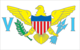
Flag description
white field with a modified US coat of arms in the center between the large blue initials V and I; the coat of arms shows a yellow eagle holding an olive branch in its right talon and three arrows in the left with a superimposed shield of seven red and six white vertical stripes below a blue panel; white is a symbol of purity, the letters stand for the Virgin Islands
Government type
presidential democracy; a self-governing territory of the US
Independence
none (territory of the US)
International organization participation
AOSIS (observer), Interpol (subbureau), IOC, UPU, WFTU (NGOs)
Judicial branch
- Supreme Court of the Virgin Islands (consists of the chief justice and 2 associate justices); note - court established by US Congress in 2004 and assumed appellate jurisdiction in 2007 justices appointed by the governor and confirmed by the Virgin Islands Senate; justices initially serve renewable 10-year terms; chief justice elected to position by peers for a 3-year term Superior Court (Territorial Court renamed in 2004); US Court of Appeals for the Third Circuit (has appellate jurisdiction over the District Court of the Virgin Islands; it is a territorial court and is not associated with a US federal judicial district); District Court of the Virgin Islands
- highest court(s)
- Supreme Court of the Virgin Islands (consists of the chief justice and 2 associate justices); note - court established by US Congress in 2004 and assumed appellate jurisdiction in 2007
- judge selection and term of office
- justices appointed by the governor and confirmed by the Virgin Islands Senate; justices initially serve renewable 10-year terms; chief justice elected to position by peers for a 3-year term
- subordinate courts
- Superior Court (Territorial Court renamed in 2004); US Court of Appeals for the Third Circuit (has appellate jurisdiction over the District Court of the Virgin Islands; it is a territorial court and is not associated with a US federal judicial district); District Court of the Virgin Islands
Legal system
US common law
Legislative branch
- unicameral Senate (15 seats; members directly elected in single- and multi-seat constituencies by simple majority popular vote to serve 2-year terms) last held on 8 November 2016 (next to be held on 6 November 2018) percent of vote by party - NA; seats by party - Democratic Party 10, ICM 1, independent 4 the Virgin Islands directly elects 1 member by simple majority vote to serve a 2-year term as a delegate to the US House of Representatives; the delegate can vote when serving on a committee and when the House meets as the Committee of the Whole House, but not when legislation is submitted for a “full floor” House vote; election of delegate last held on 8 November 2016 (next to be held on 6 November 2018)
- description
- unicameral Senate (15 seats; members directly elected in single- and multi-seat constituencies by simple majority popular vote to serve 2-year terms)
- election results
- percent of vote by party - NA; seats by party - Democratic Party 10, ICM 1, independent 4
- elections
- last held on 8 November 2016 (next to be held on 6 November 2018)
- note
- the Virgin Islands directly elects 1 member by simple majority vote to serve a 2-year term as a delegate to the US House of Representatives; the delegate can vote when serving on a committee and when the House meets as the Committee of the Whole House, but not when legislation is submitted for a “full floor” House vote; election of delegate last held on 8 November 2016 (next to be held on 6 November 2018)
National anthem
- "Virgin Islands March" multiple/Alton Augustus ADAMS, Sr. adopted 1963; serves as a local anthem; as a territory of the US, "The Star-Spangled Banner" is official (see United States)
- lyrics/music
- multiple/Alton Augustus ADAMS, Sr.
- name
- "Virgin Islands March"
- note
- adopted 1963; serves as a local anthem; as a territory of the US, "The Star-Spangled Banner" is official (see United States)
National holiday
Transfer Day (from Denmark to the US), 31 March (1917)
Political parties and leaders
Democratic Party [Donna M. CHRISTENSEN] Independent Citizens' Movement or ICM [Dale BLYDEN] Republican Party [John CANEGATA]
Political pressure groups and leaders
NA
Suffrage
18 years of age; universal; note - island residents are US citizens but do not vote in US presidential elections
Economy
Agriculture - products
fruit, vegetables, sorghum; Senepol cattle
Budget
- $1.223 billion $1.551 billion (2013)
- expenditures
- $1.551 billion (2013)
- revenues
- $1.223 billion
Budget surplus (+) or deficit (-)
-6.5% of GDP (2013)
Debt - external
$NA
Economy - overview
Tourism, trade, and other services are the primary economic activities, accounting for nearly 60% of the Virgin Island's GDP and about half of total civilian employment. The islands host nearly 3 million tourists per year, mostly from visiting cruise ships. The islands are vulnerable to damage from storms. The agriculture sector is small, with most food being imported. Industry and government each account for about one-fifth of GDP. The manufacturing sector consists of rum distilling, electronics, pharmaceuticals, and watch assembly. A refinery on St. Croix, one of the world’s largest, processed 350,000 barrels of crude oil a day until it was shut down in February 2012, after operating for 45 years. Federal programs and grants, totaling $241.4 million in 2013, contributed 19.7% of the territory’s total revenues. The economy declined in 2013, due to decreases in exports resulting from the loss of refined oil products. Nevertheless, the economy remains relatively diversified. Along with a vibrant tourism industry, rum exports, trade, and services will be major income sources in future years.
Exchange rates
the US dollar is used
Exports
$2.627 billion (2013) $3.339 billion (2012)
Exports - commodities
rum
Fiscal year
1 October - 30 September
GDP - composition, by end use
- 63.6% 28% 6.1% NA% 69.3% -66.9% (2013)
- exports of goods and services
- 69.3%
- government consumption
- 28%
- household consumption
- 63.6%
- imports of goods and services
- -66.9% (2013)
- investment in fixed assets
- 6.1%
- investment in inventories
- NA%
GDP - composition, by sector of origin
- 2% 20% 78% (2012 est.)
- agriculture
- 2%
- industry
- 20%
- services
- 78% (2012 est.)
GDP - per capita (PPP)
$36,100 (2013 est.) $39,300 (2012 est.) $40,500 (2011 est.)
GDP - real growth rate
-5.4% (2013 est.) -13.8% (2012 est.) -7.5% (2011 est.)
GDP (official exchange rate)
$5.075 billion (2013)
GDP (purchasing power parity)
- $3.792 billion (2013 est.) $4.143 billion (2012 est.) $4.288 billion (2011 est.) data are in 2013 dollars
- note
- data are in 2013 dollars
Household income or consumption by percentage share
- NA% NA%
- highest 10%
- NA%
- lowest 10%
- NA%
Imports
$2.694 billion (2013) $3.056 billion (2012)
Imports - commodities
foodstuffs, consumer goods, building materials
Industrial production growth rate
NA%
Industries
tourism, watch assembly, rum distilling, construction, pharmaceuticals, electronics
Inflation rate (consumer prices)
3.1% (2012)
Labor force
50,580 (2012 est.)
Labor force - by occupation
- 1% 19% 80% (2003 est.)
- agriculture
- 1%
- industry
- 19%
- services
- 80% (2003 est.)
Population below poverty line
28.9% (2002 est.)
Public debt
45.9% of GDP (2014)
Taxes and other revenues
24.1% of GDP (2013)
Unemployment rate
13% (2014)
Energy
Carbon dioxide emissions from consumption of energy
9.4 million Mt (2013 est.)
Crude oil - exports
0 bbl/day (2014 est.)
Crude oil - imports
0 bbl/day (2014 est.)
Crude oil - production
0 bbl/day (2016 est.)
Crude oil - proved reserves
0 bbl (1 January 2017 es)
Electricity - consumption
117.2 million kWh (2015 est.)
Electricity - exports
0 kWh (2016 est.)
Electricity - from fossil fuels
13.9% of total installed capacity (2015 est.)
Electricity - from hydroelectric plants
0% of total installed capacity (2015 est.)
Electricity - from nuclear fuels
0% of total installed capacity (2015 est.)
Electricity - from other renewable sources
1.3% of total installed capacity (2015 est.)
Electricity - imports
0 kWh (2016 est.)
Electricity - installed generating capacity
316,000 kW (2015 est.)
Electricity - production
679 million kWh (2015 est.)
Electricity access
- 10,295 91% 91% 80% (2012)
- electrification - rural areas
- 80% (2012)
- electrification - total population
- 91%
- electrification - urban areas
- 91%
- population without electricity
- 10,295
Natural gas - consumption
0 cu m (2014 est.)
Natural gas - exports
0 cu m (2014 est.)
Natural gas - imports
0 cu m (2014 est.)
Natural gas - production
0 cu m (2014 est.)
Natural gas - proved reserves
0 cu m (1 January 2014 es)
Refined petroleum products - consumption
132,000 bbl/day (2015 est.)
Refined petroleum products - exports
0 bbl/day (2014 est.)
Refined petroleum products - imports
130,000 bbl/day (2014 est.)
Refined petroleum products - production
0 bbl/day (2014 est.)
Communications
Broadcast media
about a dozen TV broadcast stations including 1 public TV station; multi-channel cable and satellite TV services are available; 24 radio stations (2009)
Internet country code
.vi
Internet users
- 57,000 54.8% (July 2016 est.)
- percent of population
- 54.8% (July 2016 est.)
- total
- 57,000
Telephone system
- modern system with total digital switching, uses fiber-optic cable and microwave radio relay full range of services available country code - 1-340; submarine cable connections to US, the Caribbean, Central and South America; satellite earth stations - NA (2016)
- domestic
- full range of services available
- general assessment
- modern system with total digital switching, uses fiber-optic cable and microwave radio relay
- international
- country code - 1-340; submarine cable connections to US, the Caribbean, Central and South America; satellite earth stations - NA (2016)
Telephones - fixed lines
- 76,000 73 (July 2016 est.)
- subscriptions per 100 inhabitants
- 73 (July 2016 est.)
- total subscriptions
- 76,000
Transportation
Airports
2 (2013)
Airports - with paved runways
- 1 (2013)
- 1,524 to 2,437 m
- 1 (2013)
- over 3,047 m
- 1
- total
- 2
Ports and terminals
- Charlotte Amalie, Christiansted, Cruz Bay, Frederiksted, Limetree Bay
- major seaport(s)
- Charlotte Amalie, Christiansted, Cruz Bay, Frederiksted, Limetree Bay
Roadways
- 1,260 km (2008)
- total
- 1,260 km (2008)
Military and Security
Military - note
defense is the responsibility of the US
Transnational Issues
Disputes - international
none