2014 Edition
CIA World Factbook 2014 Archive (HTML)
Introduction
Background
The colonial boundaries created by Britain to delimit Uganda grouped together a wide range of ethnic groups with different political systems and cultures. These differences prevented the establishment of a working political community after independence was achieved in 1962. The dictatorial regime of Idi AMIN (1971-79) was responsible for the deaths of some 300,000 opponents; guerrilla war and human rights abuses under Milton OBOTE (1980-85) claimed at least another 100,000 lives. The rule of Yoweri MUSEVENI since 1986 has brought relative stability and economic growth to Uganda. A constitutional referendum in 2005 cancelled a 19-year ban on multi-party politics.
Geography
Area
- 241,038 sq km 197,100 sq km 43,938 sq km
- total
- 241,038 sq km
- water
- 43,938 sq km
Area - comparative
slightly smaller than Oregon
Climate
tropical; generally rainy with two dry seasons (December to February, June to August); semiarid in northeast
Coastline
0 km (landlocked)
Elevation extremes
- Lake Albert 621 m Margherita Peak on Mount Stanley 5,110 m
- highest point
- Margherita Peak on Mount Stanley 5,110 m
- lowest point
- Lake Albert 621 m
Environment - current issues
draining of wetlands for agricultural use; deforestation; overgrazing; soil erosion; water hyacinth infestation in Lake Victoria; widespread poaching
Environment - international agreements
- Biodiversity, Climate Change, Climate Change-Kyoto Protocol, Desertification, Endangered Species, Hazardous Wastes, Law of the Sea, Marine Life Conservation, Ozone Layer Protection, Wetlands Environmental Modification
- party to
- Biodiversity, Climate Change, Climate Change-Kyoto Protocol, Desertification, Endangered Species, Hazardous Wastes, Law of the Sea, Marine Life Conservation, Ozone Layer Protection, Wetlands
- signed, but not ratified
- Environmental Modification
Freshwater withdrawal (domestic/industrial/agricultural)
- 0.32 cu km/yr (41%/16%/43%) 12.31 cu m/yr (2005)
- per capita
- 12.31 cu m/yr (2005)
- total
- 0.32 cu km/yr (41%/16%/43%)
Geographic coordinates
1 00 N, 32 00 E
Geography - note
landlocked; fertile, well-watered country with many lakes and rivers
Irrigated land
144.2 sq km (2010)
Land boundaries
- 2,698 km Democratic Republic of the Congo 765 km, Kenya 933 km, Rwanda 169 km, South Sudan 435 km, Tanzania 396 km
- border countries
- Democratic Republic of the Congo 765 km, Kenya 933 km, Rwanda 169 km, South Sudan 435 km, Tanzania 396 km
- total
- 2,698 km
Land use
- 27.94% 9.11% 62.95% (2011)
- arable land
- 27.94%
- other
- 62.95% (2011)
- permanent crops
- 9.11%
Location
East-Central Africa, west of Kenya, east of the Democratic Republic of the Congo
Map references
Africa
Maritime claims
none (landlocked)
Natural hazards
NA
Natural resources
copper, cobalt, hydropower, limestone, salt, arable land, gold
Terrain
mostly plateau with rim of mountains
Total renewable water resources
66 cu km (2011)
People and Society
Age structure
- 48.7% (male 8,714,354/female 8,765,900) 21.2% (male 3,775,679/female 3,833,574) 25.7% (male 4,618,088/female 4,615,616) 2.4% (male 405,740/female 447,118) 2.1% (male 327,771/female 415,075) (2014 est.)
- 0-14 years
- 48.7% (male 8,714,354/female 8,765,900)
- 15-24 years
- 21.2% (male 3,775,679/female 3,833,574)
- 25-54 years
- 25.7% (male 4,618,088/female 4,615,616)
- 55-64 years
- 2.4% (male 405,740/female 447,118)
- 65 years and over
- 2.1% (male 327,771/female 415,075) (2014 est.)
Birth rate
44.17 births/1,000 population (2014 est.)
Child labor - children ages 5-14
- 117,266 25 % data represents children ages 5-17 working in the (2010 est.)
- percentage
- 25 %
- total number
- 117,266
Children under the age of 5 years underweight
14.1% (2011)
Contraceptive prevalence rate
30% (2011)
Death rate
10.97 deaths/1,000 population (2014 est.)
Dependency ratios
- 102.4 % 97.5 % 4.9 % 20.5 (2014 est.)
- elderly dependency ratio
- 4.9 %
- potential support ratio
- 20.5 (2014 est.)
- total dependency ratio
- 102.4 %
- youth dependency ratio
- 97.5 %
Drinking water source
- urban: 94.8% of population rural: 71% of population total: 74.8% of population urban: 5.2% of population rural: 29% of population total: 25.2% of population (2012 est.)
- rural
- 29% of population
- total
- 25.2% of population (2012 est.)
- urban
- 5.2% of population
Education expenditures
3.3% of GDP (2012)
Ethnic groups
Baganda 16.9%, Banyankole 9.5%, Basoga 8.4%, Bakiga 6.9%, Iteso 6.4%, Langi 6.1%, Acholi 4.7%, Bagisu 4.6%, Lugbara 4.2%, Bunyoro 2.7%, other 29.6% (2002 census)
Health expenditures
9.5% of GDP (2011)
HIV/AIDS - adult prevalence rate
7.2% (2012 est.)
HIV/AIDS - deaths
63,300 (2012 est.)
HIV/AIDS - people living with HIV/AIDS
1,549,200 (2012 est.)
Hospital bed density
0.5 beds/1,000 population (2010)
Infant mortality rate
- 60.82 deaths/1,000 live births 70.17 deaths/1,000 live births 51.18 deaths/1,000 live births (2014 est.)
- female
- 51.18 deaths/1,000 live births (2014 est.)
- total
- 60.82 deaths/1,000 live births
Languages
English (official national language, taught in grade schools, used in courts of law and by most newspapers and some radio broadcasts), Ganda or Luganda (most widely used of the Niger-Congo languages, preferred for native language publications in the capital and may be taught in school), other Niger-Congo languages, Nilo-Saharan languages, Swahili, Arabic
Life expectancy at birth
- 54.46 years 53.1 years 55.86 years (2014 est.)
- female
- 55.86 years (2014 est.)
- total population
- 54.46 years
Literacy
- age 15 and over can read and write 73.2% 82.6% 64.6% (2010 est.)
- definition
- age 15 and over can read and write
- female
- 64.6% (2010 est.)
- male
- 82.6%
- total population
- 73.2%
Major infectious diseases
- very high bacterial diarrhea, hepatitis A and E, and typhoid fever malaria, dengue fever, and trypanosomiasis-Gambiense (African sleeping sickness) schistosomiasis rabies (2013)
- animal contact disease
- rabies (2013)
- degree of risk
- very high
- food or waterborne diseases
- bacterial diarrhea, hepatitis A and E, and typhoid fever
- vectorborne diseases
- malaria, dengue fever, and trypanosomiasis-Gambiense (African sleeping sickness)
- water contact disease
- schistosomiasis
Major urban areas - population
KAMPALA (capital) 1.659 million (2011)
Maternal mortality rate
310 deaths/100,000 live births (2010)
Median age
- 15.5 years 15.5 years 15.6 years (2014 est.)
- female
- 15.6 years (2014 est.)
- male
- 15.5 years
- total
- 15.5 years
Mother's mean age at first birth
18.9 median age at first birth among women 25-29 (2011 est.)
Nationality
- Ugandan(s) Ugandan
- adjective
- Ugandan
- noun
- Ugandan(s)
Net migration rate
-0.76 migrant(s)/1,000 population (2014 est.)
Obesity - adult prevalence rate
4.3% (2008)
Physicians density
0.12 physicians/1,000 population (2005)
Population
35,918,915 estimates for this country explicitly take into account the effects of excess mortality due to AIDS; this can result in lower life expectancy, higher infant mortality, higher death rates, lower population growth rates, and changes in the distribution of population by age and sex than would otherwise be expected (July 2014 est.)
Population growth rate
3.24% (2014 est.)
Religions
Roman Catholic 41.9%, Protestant 42% (Anglican 35.9%, Pentecostal 4.6%, Seventh-Day Adventist 1.5%), Muslim 12.1%, other 3.1%, none 0.9% (2002 census)
Sanitation facility access
- urban: 32.8% of population rural: 34.1% of population total: 33.9% of population urban: 67.2% of population rural: 65.9% of population total: 66.1% of population (2012 est.)
- rural
- 65.9% of population
- total
- 66.1% of population (2012 est.)
- urban
- 67.2% of population
School life expectancy (primary to tertiary education)
- 11 years 11 years 11 years (2009)
- female
- 11 years (2009)
- male
- 11 years
- total
- 11 years
Sex ratio
- 1.03 male(s)/female 0.99 male(s)/female 0.99 male(s)/female 1 male(s)/female 0.99 male(s)/female 0.8 male(s)/female 0.99 male(s)/female (2014 est.)
- 0-14 years
- 0.99 male(s)/female
- 15-24 years
- 0.99 male(s)/female
- 25-54 years
- 1 male(s)/female
- 55-64 years
- 0.99 male(s)/female
- 65 years and over
- 0.8 male(s)/female
- at birth
- 1.03 male(s)/female
- total population
- 0.99 male(s)/female (2014 est.)
Total fertility rate
5.97 children born/woman (2014 est.)
Unemployment, youth ages 15-24
- 5.4% (2009)
- total
- 5.4% (2009)
Urbanization
- 15.6% of total population (2011) 5.74% annual rate of change (2010-15 est.)
- rate of urbanization
- 5.74% annual rate of change (2010-15 est.)
- urban population
- 15.6% of total population (2011)
Government
Administrative divisions
111 districts and 1 capital city*; Abim, Adjumani, Agago, Alebtong, Amolatar, Amudat, Amuria, Amuru, Apac, Arua, Budaka, Bududa, Bugiri, Buhweju, Buikwe, Bukedea, Bukomansimbi, Bukwa, Bulambuli, Buliisa, Bundibugyo, Bushenyi, Busia, Butaleja, Butambala, Buvuma, Buyende, Dokolo, Gomba, Gulu, Hoima, Ibanda, Iganga, Isingiro, Jinja, Kaabong, Kabale, Kabarole, Kaberamaido, Kalangala, Kaliro, Kalungu, Kampala*, Kamuli, Kamwenge, Kanungu, Kapchorwa, Kasese, Katakwi, Kayunga, Kibaale, Kiboga, Kibuku, Kiruhura, Kiryandongo, Kisoro, Kitgum, Koboko, Kole, Kotido, Kumi, Kween, Kyankwanzi, Kyegegwa, Kyenjojo, Lamwo, Lira, Luuka, Luwero, Lwengo, Lyantonde, Manafwa, Maracha, Masaka, Masindi, Mayuge, Mbale, Mbarara, Mitooma, Mityana, Moroto, Moyo, Mpigi, Mubende, Mukono, Nakapiripirit, Nakaseke, Nakasongola, Namayingo, Namutumba, Napak, Nebbi, Ngora, Ntoroko, Ntungamo, Nwoya, Otuke, Oyam, Pader, Pallisa, Rakai, Rubirizi, Rukungiri, Sembabule, Serere, Sheema, Sironko, Soroti, Tororo, Wakiso, Yumbe, Zombo
Capital
- Kampala 0 19 N, 32 33 E UTC+3 (8 hours ahead of Washington, DC, during Standard Time)
- geographic coordinates
- 0 19 N, 32 33 E
- name
- Kampala
- time difference
- UTC+3 (8 hours ahead of Washington, DC, during Standard Time)
Constitution
several previous; latest adopted 27 September 1995, promulgated 8 October 1995; amended many times, last in 2005 (2011)
Country name
- Republic of Uganda Uganda
- conventional long form
- Republic of Uganda
- conventional short form
- Uganda
Diplomatic representation from the US
- Ambassador Scott H. DELISI (since 18 July 2012) 1577 Ggaba Road, Kampala P. O. Box 7007, Kampala [256] (414) 259 791 through 93, 95 [256] (414) 259-794
- chief of mission
- Ambassador Scott H. DELISI (since 18 July 2012)
- embassy
- 1577 Ggaba Road, Kampala
- FAX
- [256] (414) 259-794
- mailing address
- P. O. Box 7007, Kampala
- telephone
- [256] (414) 259 791 through 93, 95
Diplomatic representation in the US
- Ambassador Oliver WONEKHA (since 6 June 2013) 5911 16th Street NW, Washington, DC 20011 [1] (202) 726-7100 through 7102, 0416 [1] (202) 726-1727
- chancery
- 5911 16th Street NW, Washington, DC 20011
- chief of mission
- Ambassador Oliver WONEKHA (since 6 June 2013)
- FAX
- [1] (202) 726-1727
- telephone
- [1] (202) 726-7100 through 7102, 0416
Executive branch
- President Lt. Gen. Yoweri Kaguta MUSEVENI (since seizing power on 26 January 1986); Vice President Edward SSEKANDI (since 24 May 2011) note - the president is both chief of state and head of government President Lt. Gen. Yoweri Kaguta MUSEVENI (since seizing power on 26 January 1986); Prime Minister Amama MBABAZI (since 24 May 2011); note - the prime minister assists the president in supervising the cabinet Cabinet appointed by the president from among elected legislators president elected by popular vote for a five-year term; election last held on 18 February 2011 (next to be held in 2016) Lt. Gen. Yoweri Kaguta MUSEVENI re-elected president; percent of vote - Lt. Gen. Yoweri Kaguta MUSEVENI 68.4%, Kizza BESIGYE 26.0%, other 5.6%
- cabinet
- Cabinet appointed by the president from among elected legislators
- chief of state
- President Lt. Gen. Yoweri Kaguta MUSEVENI (since seizing power on 26 January 1986); Vice President Edward SSEKANDI (since 24 May 2011) note - the president is both chief of state and head of government
- election results
- Lt. Gen. Yoweri Kaguta MUSEVENI re-elected president; percent of vote - Lt. Gen. Yoweri Kaguta MUSEVENI 68.4%, Kizza BESIGYE 26.0%, other 5.6%
- elections
- president elected by popular vote for a five-year term; election last held on 18 February 2011 (next to be held in 2016)
- head of government
- President Lt. Gen. Yoweri Kaguta MUSEVENI (since seizing power on 26 January 1986); Prime Minister Amama MBABAZI (since 24 May 2011); note - the prime minister assists the president in supervising the cabinet
Flag description
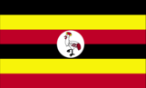
six equal horizontal bands of black (top), yellow, red, black, yellow, and red; a white disk is superimposed at the center and depicts a grey crowned crane (the national symbol) facing the hoist side; black symbolizes the African people, yellow sunshine and vitality, red African brotherhood; the crane was the military badge of Ugandan soldiers under the UK
Government type
republic
Independence
9 October 1962 (from the UK)
International law organization participation
accepts compulsory ICJ jurisdiction with reservations; accepts ICCt jurisdiction
International organization participation
ACP, AfDB, AU, C, COMESA, EAC, EADB, FAO, G-77, IAEA, IBRD, ICAO, ICC (NGOs), ICRM, IDA, IDB, IFAD, IFC, IFRCS, IGAD, ILO, IMF, Interpol, IOC, IOM, IPU, ISO (correspondent), ITSO, ITU, ITUC (NGOs), MIGA, NAM, OIC, OPCW, PCA, UN, UNAMID, UNCTAD, UNESCO, UNHCR, UNIDO, UNOCI, UNWTO, UPU, WCO, WFTU (NGOs), WHO, WIPO, WMO, WTO
Judicial branch
- Supreme Court of Uganda (consists of the chief justice and 5 justices) justices appointed by the president in consultation with the Judicial Service Commission (a 9-member independent advisory body) and with approval of the National Assembly; justices serve until mandatory retirement at age 70 Court of Appeal (also sits as the Constitutional Court); High Court (includes 10 High Court Circuits and 7 High Court Divisions); Chief Magistrate Grade One and Grade Two Courts
- highest court(s)
- Supreme Court of Uganda (consists of the chief justice and 5 justices)
- judge selection and term of office
- justices appointed by the president in consultation with the Judicial Service Commission (a 9-member independent advisory body) and with approval of the National Assembly; justices serve until mandatory retirement at age 70
- subordinate courts
- Court of Appeal (also sits as the Constitutional Court); High Court (includes 10 High Court Circuits and 7 High Court Divisions); Chief Magistrate Grade One and Grade Two Courts
Legal system
mixed legal system of English common law and customary law
Legislative branch
- unicameral National Assembly (375 seats; 238 members elected by popular vote, 112 women directly elected, 25 nominated by legally established special interest groups [army 10, disabled 5, youth 5, labor 5], additional ex-officio members may be nominated by the president; members serve five-year terms) last held on 18 February 2011 (next to be held in 2016) percent of vote by party - NA; seats by party - NRM 263, FDC 34, DP 12, UPC 10, UPDF 10, CP 1, JEEMA 1, independents 43, vacant 1; note - UPDF is the Uganda People's Defense Force
- election results
- percent of vote by party - NA; seats by party - NRM 263, FDC 34, DP 12, UPC 10, UPDF 10, CP 1, JEEMA 1, independents 43, vacant 1; note - UPDF is the Uganda People's Defense Force
- elections
- last held on 18 February 2011 (next to be held in 2016)
National anthem
- "Oh Uganda, Land of Beauty!" George Wilberforce KAKOMOA adopted 1962
- lyrics/music
- George Wilberforce KAKOMOA
- name
- "Oh Uganda, Land of Beauty!"
National holiday
Independence Day, 9 October (1962)
National symbol(s)
grey crowned crane
Political parties and leaders
Conservative Party or CP [Ken LUKYAMUZI] Democratic Party or DP [Norbert MAO] Forum for Democratic Change or FDC [Muntu MUGISHA] Inter-Party Co-operation or IPC (a coalition of opposition groups) Justice Forum or JEEMA [Asuman BASALIRWA] National Resistance Movement or NRM [Yoweri MUSEVENI] Peoples Progressive Party or PPP [Bidandi SSALI] Ugandan People's Congress or UPC [Olara OTUNNU] a national referendum in July 2005 opened the way for Uganda's transition to a multi-party political system
Political pressure groups and leaders
Lord's Resistance Army or LRA [Joseph KONY] Parliamentary Advocacy Forum or PAFO National Association of Women Organizations in Uganda or NAWOU [Florence NEKYON] The Ugandan Coalition for Political Accountability to Women or COPAW
Suffrage
18 years of age; universal
Economy
Agriculture - products
coffee, tea, cotton, tobacco, cassava (manioc, tapioca), potatoes, corn, millet, pulses, cut flowers; beef, goat meat, milk, poultry
Budget
- $3.2 billion $3.803 billion (2013 est.)
- expenditures
- $3.803 billion (2013 est.)
- revenues
- $3.2 billion
Budget surplus (+) or deficit (-)
-2.7% of GDP (2013 est.)
Central bank discount rate
14% (31 December 2010 est.) 9.65% (31 December 2009 est.)
Commercial bank prime lending rate
23.7% (31 December 2013 est.) 26.31% (31 December 2012 est.)
Current account balance
-$1.908 billion (2013 est.) -$2.232 billion (2012 est.)
Debt - external
$5.223 billion (31 December 2013 est.) $4.461 billion (31 December 2012 est.)
Distribution of family income - Gini index
44.3 (2009) 45.7 (2002)
Economy - overview
Uganda has substantial natural resources, including fertile soils, regular rainfall, small deposits of copper, gold, and other minerals, and recently discovered oil. Uganda has never conducted a national minerals survey. Agriculture is the most important sector of the economy, employing over 80% of the work force. Coffee accounts for the bulk of export revenues. Since 1986, the government - with the support of foreign countries and international agencies - has acted to rehabilitate and stabilize the economy by undertaking currency reform, raising producer prices on export crops, increasing prices of petroleum products, and improving civil service wages. The policy changes are especially aimed at dampening inflation and boosting production and export earnings. Since 1990 economic reforms ushered in an era of solid economic growth based on continued investment in infrastructure, improved incentives for production and exports, lower inflation, better domestic security, and the return of exiled Indian-Ugandan entrepreneurs. The global economic downturn hurt Uganda's exports; however, Uganda's GDP growth has largely recovered due to past reforms and sound management of the downturn. Oil revenues and taxes will become a larger source of government funding as oil comes on line in the next few years. Instability in South Sudan is a risk for the Ugandan economy because Uganda's main export partner is Sudan, and Uganda is a key destination for Sudanese refugees. Unreliable power, high energy costs, inadequate transportation infrastructure, and corruption inhibit economic development and investor confidence.
Exchange rates
Ugandan shillings (UGX) per US dollar - 2,604.6 (2013 est.) 2,505.6 (2012 est.) 2,177.6 (2010 est.) 2,030 (2009) 1,658.1 (2008)
Exports
$3.156 billion (2013 est.) $2.811 billion (2012 est.)
Exports - commodities
coffee, fish and fish products, tea, cotton, flowers, horticultural products; gold
Exports - partners
Kenya 12.3%, Rwanda 10.3%, UAE 10.2%, Democratic Republic of the Congo 9.4%, Netherlands 6.1%, Germany 5.6%, Italy 4.4% (2012)
Fiscal year
1 July - 30 June
GDP - composition, by end use
- 82.3% 7.6% 25.5% 0.2% 22.8% -38.3% (2013 est.)
- exports of goods and services
- 22.8%
- government consumption
- 7.6%
- household consumption
- 82.3%
- imports of goods and services
- -38.3%
- investment in fixed capital
- 25.5%
- investment in inventories
- 0.2%
GDP - composition, by sector of origin
- 23.1% 26.9% 50% (2013 est.)
- agriculture
- 23.1%
- industry
- 26.9%
- services
- 50% (2013 est.)
GDP - per capita (PPP)
$1,500 (2013 est.) $1,400 (2012 est.) $1,500 (2011 est.) data are in 2013 US dollars
GDP - real growth rate
5.6% (2013 est.) 2.8% (2012 est.) 6.2% (2011 est.)
GDP (official exchange rate)
$22.6 billion (2013 est.)
GDP (purchasing power parity)
$54.37 billion (2013 est.) $51.47 billion (2012 est.) $50.08 billion (2011 est.) data are in 2013 US dollars
Gross national saving
17.4% of GDP (2013 est.) 14.7% of GDP (2012 est.) 13.1% of GDP (2011 est.)
Household income or consumption by percentage share
- 2.4% 36.1% (2009 est.)
- highest 10%
- 36.1% (2009 est.)
- lowest 10%
- 2.4%
Imports
$4.858 billion (2013 est.) $5.187 billion (2012 est.)
Imports - commodities
capital equipment, vehicles, petroleum, medical supplies; cereals
Imports - partners
Kenya 15.6%, UAE 15.4%, China 12.8%, India 11.7%, South Africa 4.1%, Japan 4% (2012)
Industrial production growth rate
3.8% (2013 est.)
Industries
sugar, brewing, tobacco, cotton textiles; cement, steel production
Inflation rate (consumer prices)
6.2% (2013 est.) 14% (2012 est.)
Labor force
17.4 million (2013 est.)
Labor force - by occupation
- 82% 5% 13% (1999 est.)
- agriculture
- 82%
- industry
- 5%
- services
- 13% (1999 est.)
Market value of publicly traded shares
$7.294 billion (31 December 2012 est.) $7.727 billion (31 December 2011) $1.788 billion (31 December 2011 est.)
Population below poverty line
24.5% (2009 est.)
Public debt
30.7% of GDP (2013 est.) 26.3% of GDP (2012 est.)
Reserves of foreign exchange and gold
$3.579 billion (31 December 2013 est.) $3.167 billion (31 December 2012 est.) excludes gold
Stock of broad money
$4.049 billion (31 December 2013 est.) $3.293 billion (31 December 2012 est.)
Stock of direct foreign investment - abroad
$NA
Stock of direct foreign investment - at home
$NA
Stock of domestic credit
$3.67 billion (31 December 2013 est.) $3.042 billion (31 December 2012 est.)
Stock of narrow money
$2.455 billion (31 December 2013 est.) $2.015 billion (31 December 2012 est.)
Taxes and other revenues
14.2% of GDP (2013 est.)
Unemployment rate
NA%
Energy
Carbon dioxide emissions from consumption of energy
3.244 million Mt (2011 est.)
Crude oil - exports
0 bbl/day (2010 est.)
Crude oil - imports
0 bbl/day (2010 est.)
Crude oil - production
0 bbl/day (2012 est.)
Crude oil - proved reserves
2.5 billion bbl (1 January 2010 est.)
Electricity - consumption
2.192 billion kWh (2010 est.)
Electricity - exports
75 million kWh (2010)
Electricity - from fossil fuels
31.5% of total installed capacity (2010 est.)
Electricity - from hydroelectric plants
65.3% of total installed capacity (2010 est.)
Electricity - from nuclear fuels
0% of total installed capacity (2010 est.)
Electricity - from other renewable sources
3.2% of total installed capacity (2010 est.)
Electricity - imports
29 million kWh (2011 est.)
Electricity - installed generating capacity
539,000 kW (2010 est.)
Electricity - production
2.406 billion kWh (2010 est.)
Natural gas - consumption
0 cu m (2010 est.)
Natural gas - exports
0 cu m (2011 est.)
Natural gas - imports
0 cu m (2011 est.)
Natural gas - production
0 cu m (2011 est.)
Natural gas - proved reserves
14.16 billion cu m (1 January 2013 est.)
Refined petroleum products - consumption
16,930 bbl/day (2011 est.)
Refined petroleum products - exports
0 bbl/day (2010 est.)
Refined petroleum products - imports
22,990 bbl/day (2010 est.)
Refined petroleum products - production
0 bbl/day (2010 est.)
Communications
Broadcast media
public broadcaster, Uganda Broadcasting Corporation (UBC), operates radio and TV networks; Uganda first began licensing privately owned stations in the 1990s; by 2007 there were nearly 150 radio and 35 TV stations, mostly based in and around Kampala; transmissions of multiple international broadcasters are available in Kampala (2007)
Internet country code
.ug
Internet hosts
32,683 (2012)
Internet users
3.2 million (2009)
Telephone system
- mobile cellular service is increasing rapidly, but the number of main lines is still deficient; work underway on a national backbone information and communications technology infrastructure; international phone networks and Internet connectivity provided through satellite and VSAT applications intercity traffic by wire, microwave radio relay, and radiotelephone communication stations, fixed and mobile-cellular systems for short-range traffic; mobile-cellular teledensity about 50 per 100 persons in 2010 country code - 256; satellite earth stations - 1 Intelsat (Atlantic Ocean) and 1 Inmarsat; analog links to Kenya and Tanzania (2011)
- domestic
- intercity traffic by wire, microwave radio relay, and radiotelephone communication stations, fixed and mobile-cellular systems for short-range traffic; mobile-cellular teledensity about 50 per 100 persons in 2010
- general assessment
- mobile cellular service is increasing rapidly, but the number of main lines is still deficient; work underway on a national backbone information and communications technology infrastructure; international phone networks and Internet connectivity provided through satellite and VSAT applications
- international
- country code - 256; satellite earth stations - 1 Intelsat (Atlantic Ocean) and 1 Inmarsat; analog links to Kenya and Tanzania (2011)
Telephones - main lines in use
315,000 (2012)
Telephones - mobile cellular
16.355 million (2012)
Transportation
Airports
47 (2013)
Airports - with paved runways
- 1 (2013)
- 1,524 to 2,437 m
- 1
- 914 to 1,523 m
- 1 (2013)
- over 3,047 m
- 3
- total
- 5
Airports - with unpaved runways
- 7 (2013)
- 1,524 to 2,437 m
- 8
- 914 to 1,523 m
- 26
- over 3,047 m
- 1
- total
- 42
Ports and terminals
- Entebbe, Jinja, Port Bell (Lake Victoria)
- lake port(s)
- Entebbe, Jinja, Port Bell (Lake Victoria)
Railways
- 1,244 km 1,244 km 1.000-m gauge (2008)
- total
- 1,244 km
Roadways
- 20,000 km (does not include local roads) 3,264 km 16,736 km (2011)
- total
- 20,000 km (does not include local roads)
- unpaved
- 16,736 km (2011)
Waterways
(there are no long navigable stretches of river in Uganda; parts of the Albert Nile that flow out of Lake Albert in the northwestern part of the country are navigable; several lakes including Lake Victoria and Lake Kyoga have substantial traffic; Lake Albert is navigable along a 200-km stretch from its northern tip to its southern shores) (2011)
Military and Security
Manpower available for military service
- 7,249,271 7,025,439 (2010 est.)
- females age 16-49
- 7,025,439 (2010 est.)
- males age 16-49
- 7,249,271
Manpower fit for military service
- 4,313,068 4,200,901 (2010 est.)
- females age 16-49
- 4,200,901 (2010 est.)
- males age 16-49
- 4,313,068
Manpower reaching militarily significant age annually
- 423,923 420,236 (2010 est.)
- female
- 420,236 (2010 est.)
- male
- 423,923
Military branches
- Uganda People's Defense Force (UPDF): Land Forces (includes Marine Unit), Uganda Air Force (2013)
- Uganda People's Defense Force (UPDF)
- Land Forces (includes Marine Unit), Uganda Air Force (2013)
Military expenditures
1.45% of GDP (2012) 3.73% of GDP (2011) 1.45% of GDP (2010)
Military service age and obligation
18-26 years of age for voluntary military duty; 18-30 years of age for professionals; no conscription; 9-year service obligation; the government has stated that while recruitment under 18 years of age could occur with proper consent, "no person under the apparent age of 18 years shall be enrolled in the armed forces"; Ugandan citizenship and secondary education required (2012)
Transnational Issues
Disputes - international
Uganda is subject to armed fighting among hostile ethnic groups, rebels, armed gangs, militias, and various government forces that extend across its borders; Ugandan refugees as well as members of the Lord's Resistance Army (LRA) seek shelter in southern Sudan and the Democratic Republic of the Congo's Garamba National Park; LRA forces have also attacked Kenyan villages across the border
Refugees and internally displaced persons
- 155,742 (Democratic Republic of Congo); 13,376 (Rwanda); 10,578 (Burundi) (2013); 137,844 (South Sudan); 18,534 (Somalia) (2014) up to 29,800 (displacement in northern Uganda because of fighting between government forces and the Lord's Resistance Army; as of 2011, most of the 1.8 million people displaced to IDP camps at the height of the conflict had returned home or resettled, but many had not found durable solutions; intercommunal violence and cattle raids) (2011)
- IDPs
- up to 29,800 (displacement in northern Uganda because of fighting between government forces and the Lord's Resistance Army; as of 2011, most of the 1.8 million people displaced to IDP camps at the height of the conflict had returned home or resettled, but many had not found durable solutions; intercommunal violence and cattle raids) (2011)
- refugees (country of origin)
- 155,742 (Democratic Republic of Congo); 13,376 (Rwanda); 10,578 (Burundi) (2013); 137,844 (South Sudan); 18,534 (Somalia) (2014)