2003 Edition
CIA World Factbook 2003 (Project Gutenberg)
Introduction
Administrative divisions
- 5 provinces (welayatlar, singular - welayat): Ahal Welayaty (Ashgabat), Balkan Welayaty (Balkanabat), Dashoguz Welayaty, Lebap Welayaty (Turkmenabat), Mary Welayaty
- note
- administrative divisions have the same names as their administrative centers (exceptions have the administrative center name following in parentheses)
Age structure
0-14 years: 36.8% (male 899,954; female 855,293) 15-64 years: 59.2% (male 1,386,606; female 1,438,333) 65 years and over: 4.1% (male 74,958; female 120,400) (2003 est.)
Agriculture - products
cotton, grain; livestock
Airports
76 (2002)
Airports - with paved runways
- total
- 13 2,438 to 3,047 m: 9 1,524 to 2,437 m: 4 (2002)
Airports - with unpaved runways
- total
- 63 2,438 to 3,047 m: 7 1,524 to 2,437 m: 5 914 to 1,523 m: 10
- under 914 m
- 41 (2002) Military Turkmenistan
Area
- land
- 488,100 sq km
- total
- 488,100 sq km
- water
- 0 sq km
Area - comparative
slightly larger than California
Background
Annexed by Russia between 1865 and 1885, Turkmenistan became a Soviet republic in 1925. It achieved its independence upon the dissolution of the USSR in 1991. President NIYAZOV retains absolute control over the country and opposition is not tolerated. Extensive hydrocarbon/natural gas reserves could prove a boon to this underdeveloped country if extraction and delivery projects can be worked out. Geography Turkmenistan
Birth rate
28.02 births/1,000 population (2003 est.)
Budget
- expenditures
- $658.2 million, including capital expenditures of $NA (1999 est.)
- revenues
- $588.6 million
Capital
Ashgabat
Climate
subtropical desert
Coastline
0 km; note - Turkmenistan borders the Caspian Sea (1,768 km)
Constitution
adopted 18 May 1992
Country name
- conventional long form
- none
- conventional short form
- Turkmenistan
- former
- Turkmen Soviet Socialist Republic
- local long form
- none
- local short form
- Turkmenistan
Currency
Turkmen manat (TMM)
Currency code
TMM
Death rate
8.87 deaths/1,000 population (2003 est.)
Debt - external
$2.4 billion to $5 billion (2001 est.)
Diplomatic representation from the US
- chief of mission
- Ambassador Tracey A. JACOBSON
- embassy
- 9 Pushkin Street, Ashgabat, Turkmenistan 774000
- mailing address
- use embassy street address
- telephone
- [9] (9312) 35-00-45
Diplomatic representation in the US
- chief of mission
- Ambassador Mered Bairamovich ORAZOV
Disputes - international
prolonged regional drought creates water-sharing difficulties for Amu Darya river states; Turkmenistan has not committed to follow either Iran or the other littoral states in the division of the Caspian Sea seabed and water column; ICJ decision expected to resolve dispute with Azerbaijan over sovereignty over Caspian oilfields; demarcation of land boundary with Kazakhstan is underway - maritime boundary not resolved
Distribution of family income - Gini index
40.8 (1998)
Economic aid - recipient
$16 million from the US (2001)
Economy - overview
Turkmenistan is largely desert country with intensive agriculture in irrigated oases and large gas and oil resources. One-half of its irrigated land is planted in cotton, making it the world's tenth-largest producer. With an authoritarian ex-Communist regime in power and a tribally based social structure, Turkmenistan has taken a cautious approach to economic reform, hoping to use gas and cotton sales to sustain its inefficient economy. Privatization goals remain limited. In 1998-2003, Turkmenistan suffered from the continued lack of adequate export routes for natural gas and from obligations on extensive short-term external debt. At the same time, however, total exports rose by 38% in 2003, largely because of higher international oil and gas prices. Overall prospects in the near future are discouraging because of widespread internal poverty, the burden of foreign debt, and the unwillingness of the government to adopt market-oriented reforms. However, Turkmenistan's cooperation with the international community in transporting humanitarian aid to Afghanistan may foreshadow a change in the atmosphere for foreign investment, aid, and technological support. Turkmenistan's economic statistics are state secrets, and GDP and other figures are subject to wide margins of error. In any event, GDP increased substantially in 2003 because of a strong recovery in agriculture and rapid industrial growth.
Electricity - consumption
8.509 billion kWh (2001)
Electricity - exports
980 million kWh (2001)
Electricity - imports
20 million kWh (2001)
Electricity - production
10.18 billion kWh (2001)
Electricity - production by source
- fossil fuel
- 99.9%
- hydro
- 0.1%
- nuclear
- 0%
- other
- 0% (2001)
Elevation extremes
- highest point
- Gora Ayribaba 3,139 m
- lowest point
- Vpadina Akchanaya -81 m; note - Sarygamysh Koli is a lake in northern Turkmenistan with a water level that fluctuates above and below the elevation of Vpadina Akchanaya (the lake has dropped as low as -110 m)
Environment - current issues
contamination of soil and groundwater with agricultural chemicals, pesticides; salination, water-logging of soil due to poor irrigation methods; Caspian Sea pollution; diversion of a large share of the flow of the Amu Darya into irrigation contributes to that river's inability to replenish the Aral Sea; desertification
Environment - international agreements
- party to
- Biodiversity, Climate Change, Climate Change-Kyoto Protocol, Desertification, Hazardous Wastes, Ozone Layer Protection
- signed, but not ratified
- none of the selected agreements
Ethnic groups
Turkmen 77%, Uzbek 9.2%, Russian 6.7%, Kazakh 2%, other 5.1% (1995)
Exchange rates
Turkmen manats per US dollar - 5,200 (2002), 5,200 (2001), 5,200 (2000), 5,200 (1999), 4,890.17 (1998); note - the official exchange rate has not varied for the last four years; the unofficial rate has fluctuated slightly, hovering around 21,000 manats to the dollar
Executive branch
- cabinet
- Council of Ministers appointed by the president
- chief of state
- President and Chairman of the Cabinet of Ministers Saparmurat NIYAZOV (since 27 October 1990, when the first direct presidential election occurred); note - the president is both the chief of state and head of government
- election results
- Saparmurat NIYAZOV elected president without opposition; percent of vote - Saparmurat NIYAZOV 99.5%
- elections
- president elected by popular vote for a five-year term; election last held 21 June 1992 (next to be held NA); note - President NIYAZOV was unanimously approved as president for life by the Assembly on 28 December 1999); deputy chairmen of the cabinet of ministers are appointed by the president
- head of government
- President and Chairman of the Cabinet of Ministers Saparmurat NIYAZOV (since 27 October 1990, when the first direct presidential election occurred); note - the president is both the chief of state and head of government
- note
- NIYAZOV's term in office was extended indefinitely on 28 December 1999 by the Assembly (Majlis) during a session of the People's Council (Halk Maslahaty)
Exports
$2.97 billion f.o.b. (2002 est.)
Exports - commodities
gas 57%, oil 26%, cotton fiber 3%, textiles 2% (2001)
Exports - partners
Ukraine 49.7%, Italy 18%, Iran 13.1%, Turkey 6.2% (2002)
FAX
- [1] (202) 588-0697
- [9] (9312) 39-26-14
- chancery
- 2207 Massachusetts Avenue NW, Washington, DC 20008
- telephone
- [1] (202) 588-1500
Fiscal year
calendar year Communications Turkmenistan
Flag description
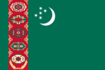
green field with a vertical red stripe near the hoist side, containing five carpet guls (designs used in producing rugs) stacked above two crossed olive branches similar to the olive branches on the UN flag; a white crescent moon and five white stars appear in the upper corner of the field just to the fly side of the red stripe Economy Turkmenistan
GDP
purchasing power parity - $31.34 billion (2002 est.)
GDP - composition by sector
- agriculture
- 27%
- industry
- 50%
- services
- 23% (2001 est.)
GDP - per capita
purchasing power parity - $6,700 (2002 est.)
GDP - real growth rate
21.1% (2002 est.)
Geographic coordinates
40 00 N, 60 00 E
Geography - note
landlocked; the western and central low-lying, desolate portions of the country make up the great Garagum (Kara-Kum) desert, which occupies over 80% of the country; eastern part is plateau People Turkmenistan
Government type
republic
Highways
- paved
- 19,488 km
- total
- 24,000 km
- unpaved
- 4,512 km (1999 est.)
HIV/AIDS - adult prevalence rate
less than 0.1% (2001 est.)
HIV/AIDS - deaths
less than 100 (2001 est.)
HIV/AIDS - people living with HIV/AIDS
less than 100 (1999 est.)
Household income or consumption by percentage share
- highest 10%
- 31.7% (1998)
- lowest 10%
- 2.6%
Illicit drugs
transit country for Afghan narcotics bound for Russian and, to a lesser extent, Western European markets; limited illicit cultivation of opium poppy for domestic consumption; small-scale government-run eradication of illicit crops; transit point for heroin precursor chemicals bound for Afghanistan This page was last updated on 18 December, 2003
Imports
$2.25 billion f.o.b. (2002 est.)
Imports - commodities
machinery and equipment 60%, foodstuffs 15% (1999)
Imports - partners
Russia 19.8%, Turkey 12.8%, Ukraine 11.7%, UAE 10%, US 7.5%, China 6%, Germany 5.7%, Iran 4.4% (2002)
Independence
27 October 1991 (from the Soviet Union)
Industrial production growth rate
1% (2002 est.)
Industries
natural gas, oil, petroleum products, textiles, food processing
Infant mortality rate
- female
- 69.25 deaths/1,000 live births (2003 est.)
- male
- 76.9 deaths/1,000 live births
- total
- 73.17 deaths/1,000 live births
Inflation rate (consumer prices)
5% (2002 est.)
International organization participation
AsDB, CIS, EAPC, EBRD, ECE, ECO, ESCAP, FAO, G-77, IBRD, ICAO, ICRM, IDB, IFC, IFRCS, ILO, IMF, IMO, IOC, IOM (observer), ISO (correspondent), ITU, NAM, OIC, OPCW, OSCE, PFP, UN, UNCTAD, UNESCO, UNIDO, UPU, WCO, WFTU, WHO, WIPO, WMO, WToO, WTrO (observer)
Internet country code
.tm
Internet Service Providers (ISPs)
1
Internet users
2,000 (2000) Transportation Turkmenistan
Irrigated land
17,500 sq km (2003 est.)
Judicial branch
Supreme Court (judges are appointed by the president)
Labor force
2.34 million (1996)
Labor force - by occupation
agriculture 48%, industry 15%, services 37% (1998 est.)
Land boundaries
- border countries
- Afghanistan 744 km, Iran 992 km, Kazakhstan 379 km, Uzbekistan 1,621 km
- total
- 3,736 km
Land use
- arable land
- 3.47%
- other
- 96.39% (1998 est.)
- permanent crops
- 0.14%
Languages
Turkmen 72%, Russian 12%, Uzbek 9%, other 7%
Legal system
based on civil law system
Legislative branch
- under the 1992 constitution, there are two parliamentary bodies, a unicameral People's Council or Halk Maslahaty (more than 100 seats, some of which are elected by popular vote and some of which are appointed; meets at least yearly) and a unicameral Assembly or Majlis (50 seats; members are elected by popular vote to serve five-year terms)
- election results
- Assembly - percent of vote by party - NA%; seats by party - NA; note - all 50 elected officials preapproved by President NIYAZOV; most are from the DPT
- elections
- People's Council - NA; Assembly - last held 12 December 1999 (next to be held NA 2004)
Life expectancy at birth
- female
- 64.84 years (2003 est.)
- male
- 57.72 years
- total population
- 61.19 years
Literacy
- definition
- age 15 and over can read and write
- female
- 97% (1989 est.) Government Turkmenistan
- male
- 99%
- total population
- 98%
Location
Central Asia, bordering the Caspian Sea, between Iran and Kazakhstan
Map references
Asia
Maritime claims
none (landlocked)
Median age
- female
- 22 years (2002)
- male
- 20.2 years
- total
- 21.1 years
Merchant marine
- ships by type
- combination ore/oil 1, petroleum tanker 1 (2002 est.)
- total
- 2 ships (1,000 GRT or over) 6,873 GRT/8,345 DWT
Military branches
Ministry of Defense (Army, Air and Air Defense, Navy, Border Troops, and Internal Troops), National Guard
Military expenditures - dollar figure
$90 million (FY99)
Military expenditures - percent of GDP
3.4% (FY99) Transnational Issues Turkmenistan
Military manpower - availability
- males age 15-49
- 1,239,737 (2003 est.)
Military manpower - fit for military service
- males age 15-49
- 1,005,686 (2003 est.)
Military manpower - military age
18 years of age (2003 est.)
Military manpower - reaching military age annually
- males
- 53,825 (2003 est.)
National holiday
Independence Day, 27 October (1991)
Nationality
- adjective
- Turkmen
- noun
- Turkmen(s)
Natural gas - consumption
9.6 billion cu m (2001 est.)
Natural gas - exports
38.6 billion cu m (2001 est.)
Natural gas - imports
0 cu m (2001 est.)
Natural gas - production
48.2 billion cu m (2001 est.)
Natural gas - proved reserves
1.43 trillion cu m (37257)
Natural hazards
NA
Natural resources
petroleum, natural gas, coal, sulfur, salt
Net migration rate
-0.92 migrant(s)/1,000 population (2003 est.)
Oil - consumption
63,000 bbl/day (2001 est.)
Oil - exports
NA (2001)
Oil - imports
NA (2001)
Oil - production
162,500 bbl/day (2001 est.)
Oil - proved reserves
273 million bbl (37257)
Pipelines
gas 6,634 km; oil 853 km (2003)
Political parties and leaders
- Democratic Party of Turkmenistan or DPT [Saparmurat NIYAZOV]
- note
- formal opposition parties are outlawed; unofficial, small opposition movements exist underground or in foreign countries; the two most prominent opposition groups-in-exile have been Gundogar and Erkin; Gundogar was led by former Foreign Minister Boris SHIKHUMRADOV until his arrest and imprisonment in the wake of the 25 November 2002 assassination attempt on President NIYAZOV; Erkin is led by former Foreign Minister Abdy KULIEV and is based out of Moscow
Political pressure groups and leaders
NA
Population
4,775,544 (July 2003 est.)
Population below poverty line
34.4% (2001 est.)
Population growth rate
1.82% (2003 est.)
Ports and harbors
Turkmenbasy
Radio broadcast stations
AM 16, FM 8, shortwave 2 (1998)
Radios
1.225 million (1997)
Railways
- broad gauge
- 2,440 km 1.520-m gauge (2002)
- total
- 2,440 km
Religions
Muslim 89%, Eastern Orthodox 9%, unknown 2%
Sex ratio
- at birth
- 1.05 male(s)/female
- total population
- 0.98 male(s)/female (2003 est.)
- under 15 years
- 1.05 male(s)/female 15-64 years: 0.96 male(s)/female 65 years and over: 0.62 male(s)/female
Suffrage
18 years of age; universal
Telephone system
- domestic
- NA
- general assessment
- poorly developed
- international
- linked by cable and microwave radio relay to other CIS republics and to other countries by leased connections to the Moscow international gateway switch; a new telephone link from Ashgabat to Iran has been established; a new exchange in Ashgabat switches international traffic through Turkey via Intelsat; satellite earth stations - 1 Orbita and 1 Intelsat
Telephones - main lines in use
363,000 (1997)
Telephones - mobile cellular
4,300 (1998)
Television broadcast stations
3 (much programming relayed from Russia and Turkey) (1997)
Televisions
820,000 (1997)
Terrain
flat-to-rolling sandy desert with dunes rising to mountains in the south; low mountains along border with Iran; borders Caspian Sea in west
Total fertility rate
3.5 children born/woman (2003 est.)
Unemployment rate
NA%
Waterways
the Amu Darya is an important inland waterway for Turkmenistan, as is the man-made Kara Kum canal