1994 Edition
CIA World Factbook 1994 (Project Gutenberg)
Introduction
Administrative divisions
5 welayatlar (singular - welayat): Ahal Welayaty (Ashgabat), Balkan Welayaty (Nebitdag), Dashhowuz Welayaty (formerly Tashauz), Lebap Welayaty (Charjew), Mary Welayaty note: names in parentheses are administrative centers when name differs from welayat name
Agriculture
cotton, grain, animal husbandry
Airports
total: 7 usable: 7 with permanent-surface runways: 4 with runways over 3,659 m: with runways 2,440-3,659 m: with runways 1,220-2,439 m: 4
Area
total area: 488,100 sq km land area: 488,100 sq km comparative area: slightly larger than California
Assembly (Majlis)
elections last held 7 January 1990 (next to be held late 1994 or early 1995); results - percent of vote by party NA; seats - (175 total) elections not officially by party, but Communist Party members won nearly 90% of seats; note - seats to be reduced to 50 at next election
Birth rate
30.42 births/1,000 population (1994 est.)
Branches
National Guard, Republic Security Forces (internal and border troops), Joint Command Turkmenistan/Russia (Ground, Navy or Caspian Sea Flotilla, Air, and Air Defense)
Budget
revenues: $NA expenditures: $NA, including capital expenditures of $NA
Capital
Ashgabat
Climate
subtropical desert
Coastline
0 km note: Turkmenistan borders the Caspian Sea (1,768 km)
Constitution
adopted 18 May 1992
Currency
Turkmenistan introduced its national currency, the manat, on 1 November 1993
Death rate
7.44 deaths/1,000 population (1994 est.)
Defense expenditures
$NA, NA% of GDP
Digraph
TX
Diplomatic representation in US
chief of mission: Ambassador Khalil UGUR chancery: 1511 K Street NW, Suite 412, Washington, DC, 20005 telephone: NA
Economic aid
recipient: Turkmenistan has received about $200 million in bilateral aid credits
Electricity
capacity: 2,920,000 kW production: 13.1 billion kWh consumption per capita: 3,079 kWh (1992)
Environment
current issues: contamination of soil and groundwater with agricultural chemicals, pesticides; salinization, water-logging of soil due to poor irrigation methods; Caspian Sea pollution; diversion of a large share of the flow of the Amu Darya river into irrigation contributes to that river's inability to replenish the Aral Sea; desertification natural hazards: NA international agreements: party to - Ozone Layer Protection
Ethnic divisions
Turkmen 73.3%, Russian 9.8%, Uzbek 9%, Kazakh 2%, other 5.9%
Exchange rates
NA
Executive branch
chief of state: President Saparmurad NIYAZOV (since NA October 1990); election last held 21 June 1992 (next to be held NA 2002); results - Saparmurad NIYAZOV 99.5% (ran unopposed); note - a 15 January 1994 referendum extended NIYAZOV's term an additional five years until 2002 (99.99% approval) head of government: Prime Minister (vacant); Deputy Prime Ministers Batyr SARDJAEV, Valery G. OCHERTSOV, Orazgeldi AIDOGDIEV, Djourakuli BABAKULIYEV, Rejep SAPAROV, Boris SHIKHMURADOV, Abad RIZAEVA, Yagmur OVEZOV (since NA) cabinet: Council of Ministers
Exports
$1.2 billion to states outside the FSU (1993) commodities: natural gas, cotton, petroleum products, textiles, carpets partners: Ukraine, Russia, Kazakhstan, Uzbekistan, Georgia, Eastern Europe, Turkey, Argentina
External debt
NEGL
Fiscal year
calendar year
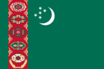
Flag
green field, including a vertical stripe on the hoist side, with a claret vertical stripe in between containing five white, black, and orange carpet guls (an assymetrical design used in producing rugs) associated with five different tribes; a white crescent and five white stars in the upper left corner to the right of the carpet guls
Highways
total: 23,000 km paved and gravel: 18,300 km unpaved: earth 4,700 km (1990)
Illicit drugs
illicit producer of cannabis and opium; mostly for CIS consumption; limited government eradication program; used as transshipment points for illicit drugs from Southwest Asia to Western Europe
Imports
$490 million from states outside the FSU (1993) commodities: machinery and parts, grain and food, plastics and rubber, consumer durables, textiles partners: Russia, Azerbaijan, Uzbekistan, Kazakhstan, Turkey
Independence
27 October 1991 (from the Soviet Union)
Industrial production
growth rate 5.3% (1993)
Industries
natural gas, oil, petroleum products, textiles, food processing
Infant mortality rate
69.9 deaths/1,000 live births (1994 est.)
Inflation rate (consumer prices)
45% per month (1993 est.)
International disputes
Russia may dispute current de facto maritime border to midpoint of Caspian Sea from shore
Irrigated land
12,450 sq km (1990)
Judicial branch
Supreme Court
Labor force
1.573 million by occupation: agriculture and forestry 44%, industry and construction 20%, other 36% (1992)
Land boundaries
total 3,736 km, Afghanistan 744 km, Iran 992 km, Kazakhstan 379 km, Uzbekistan 1,621 km
Land use
arable land: 3% permanent crops: 0% meadows and pastures: 69% forest and woodland: 0% other: 28%
Languages
Turkmen 72%, Russian 12%, Uzbek 9%, other 7%
Legal system
based on civil law system
Legislative branch
under 1992 constitution there are two parliamentary bodies, a unicameral People's Council (Halk Maslahaty - having more than 100 members and meeting infrequently) and a 50-member unicameral Assembly (Majlis)
Life expectancy at birth
total population: 65.14 years male: 61.63 years female: 68.82 years (1994 est.)
Literacy
age 9-49 can read and write (1970) total population: 100% male: 100% female: 100%
Location
Central Asia, bordering the Caspian Sea, between Iran and Uzbekistan
Manpower availability
males age 15-49 962,987; fit for military service 787,991; reach military age (18) annually 40,079 (1994 est.)
Map references
Asia, Commonwealth of Independent States - Central Asian States, Standard Time Zones of the World
Maritime claims
landlocked, but boundaries in the Caspian Sea with Azerbaijan, Kazakhstan, and Iran are under negotiations
Member of
CIS, CSCE, EBRD, ECE, ECO, ESCAP, IBRD, ICAO, IDB, ILO, IMF, IMO, INTELSAT (nonsignatory user), IOC, ITU, NACC, OIC, UN, UNCTAD, UNESCO, UPU, WHO, WMO
Names
conventional long form: none conventional short form: Turkmenistan local long form: Tiurkmenostan Respublikasy local short form: Turkmenistan former: Turkmen Soviet Socialist Republic
National holiday
Independence Day, 27 October (1991)
National product
GDP - purchasing power equivalent - $13 billion (1993 estimate from the UN International Comparison Program, as extended to 1991 and published in the World Bank's World Development Report 1993; and as extrapolated to 1993 using official Turkmen statistics, which are very uncertain because of major economic changes since 1990)
National product per capita
$3,330 (1993 est.)
National product real growth rate
7.8% (1993 est.)
Nationality
noun: Turkmen(s) adjective: Turkmen
Natural resources
petroleum, natural gas, coal, sulphur, salt
Net migration rate
-2.89 migrant(s)/1,000 population (1994 est.)
Note
landlocked
Overview
Turkmenistan is a largely desert country with nomadic cattle raising, intensive agriculture in irrigated oases, and huge gas and oil resources. Half of its irrigated land is planted in cotton; it is the world's tenth largest producer. It also is the world's fourth largest producer of natural gas and has the fifth largest reserves. Furthermore, Turkmenistan has substantial oil resources; its two oil refineries make it an exporter of refined products. Profiting from the move toward market prices for its oil and gas resources, Turkmenistan has suffered the least economic decline of the 15 states of the former USSR. With an authoritarian ex-Communist regime in power and a tribally based social structure, Turkmenistan has taken a cautious approach to questions of economic reform, using the profits from its gas and cotton exports to sustain a generally inefficient economy. Economic restructuring and privatization have just begun, and price liberalization and price increases have been accompanied by generous wage hikes and subsidies. At the same time, Turkmenistan faces serious constraints on its gas and oil earnings because of the inability of its traditional regional customers to pay for the current level of purchases and the lack of pipeline access to hard currency markets. Faced with financial shortfalls, rampant inflation, and the desire to ensure a stable currency, the regime has become more receptive to market reforms yet still seeks to offer widespread social benefits to its population and to retain state domination over the economy.
Pipelines
crude oil 250 km; natural gas 4,400 km
Political parties and leaders
ruling party: Democratic Party (formerly Communist), chairman vacant opposition: Party for Democratic Development, Durdymurat HOJA-MUKHAMMED, chairman; Agzybirlik, Nurberdy NURMAMEDOV, cochairman, Hubayberdi HALLIYEV, cochairman note: formal opposition parties are outlawed; unofficial, small opposition movements exist
Population
3,995,122 (July 1994 est.)
Population growth rate
2.01% (1994 est.)
Ports
inland - Krasnowodsk (Caspian Sea)
Railroads
2,120 km; does not include industrial lines (1990)
Religions
Muslim 87%, Eastern Orthodox 11%, unknown 2%
Suffrage
18 years of age; universal
Telecommunications
poorly developed; only 7.5 telephone circuits per 100 persons (1991); linked by cable and microwave to other CIS republics and to other countries by leased connections to the Moscow international gateway switch; a new telephone link from Ashgabat to Iran has been established; a new exchange in Ashgabat switches international traffic through Turkey via INTELSAT; satellite earth stations - 1 Orbita and 1 INTELSAT
Terrain
flat-to-rolling sandy desert with dunes rising to mountains in the south; low mountains along border with Iran; borders Caspian Sea in west
Total fertility rate
3.77 children born/woman (1994 est.)
Type
republic
Unemployment rate
2.9% (1992 est.); includes only officially registered unemployed; also large number of underemployed
US diplomatic representation
chief of mission: Ambassador Joseph S. HULINGS III embassy: Yubilenaya Hotel, Ashgabat mailing address: use embassy street address telephone: [7] 36320 24-49-25 or 24-49-26