2011 Edition
CIA World Factbook 2011 Archive (HTML)
Introduction
Background
French Togoland became Togo in 1960. Gen. Gnassingbe EYADEMA, installed as military ruler in 1967, ruled Togo with a heavy hand for almost four decades. Despite the facade of multiparty elections instituted in the early 1990s, the government was largely dominated by President EYADEMA, whose Rally of the Togolese People (RPT) party has maintained power almost continually since 1967 and maintains a majority of seats in today's legislature. Upon EYADEMA's death in February 2005, the military installed the president's son, Faure GNASSINGBE, and then engineered his formal election two months later. Democratic gains since then allowed Togo to hold its first relatively free and fair legislative elections in October 2007. After years of political unrest and condemnation from international organizations for human rights abuses, Togo is finally being re-welcomed into the international community.
Geography
Area
- 56,785 sq km 54,385 sq km 2,400 sq km
- total
- 56,785 sq km
- water
- 2,400 sq km
Area - comparative
slightly smaller than West Virginia
Climate
tropical; hot, humid in south; semiarid in north
Coastline
56 km
Elevation extremes
- Atlantic Ocean 0 m Mont Agou 986 m
- highest point
- Mont Agou 986 m
- lowest point
- Atlantic Ocean 0 m
Environment - current issues
deforestation attributable to slash-and-burn agriculture and the use of wood for fuel; water pollution presents health hazards and hinders the fishing industry; air pollution increasing in urban areas
Environment - international agreements
- Biodiversity, Climate Change, Climate Change-Kyoto Protocol, Desertification, Endangered Species, Law of the Sea, Ozone Layer Protection, Ship Pollution, Tropical Timber 83, Tropical Timber 94, Wetlands, Whaling none of the selected agreements
- party to
- Biodiversity, Climate Change, Climate Change-Kyoto Protocol, Desertification, Endangered Species, Law of the Sea, Ozone Layer Protection, Ship Pollution, Tropical Timber 83, Tropical Timber 94, Wetlands, Whaling
- signed, but not ratified
- none of the selected agreements
Freshwater withdrawal (domestic/industrial/agricultural)
- 0.17 cu km/yr (53%/2%/45%) 28 cu m/yr (2000)
- per capita
- 28 cu m/yr (2000)
- total
- 0.17 cu km/yr (53%/2%/45%)
Geographic coordinates
8 00 N, 1 10 E
Geography - note
the country's length allows it to stretch through six distinct geographic regions; climate varies from tropical to savanna
Irrigated land
70 sq km (2008)
Land boundaries
- 1,647 km Benin 644 km, Burkina Faso 126 km, Ghana 877 km
- border countries
- Benin 644 km, Burkina Faso 126 km, Ghana 877 km
- total
- 1,647 km
Land use
- 44.2% 2.11% 53.69% (2005)
- arable land
- 44.2%
- other
- 53.69% (2005)
- permanent crops
- 2.11%
Location
Western Africa, bordering the Bight of Benin, between Benin and Ghana
Map references
Africa
Maritime claims
- 30 nm 200 nm
- exclusive economic zone
- 200 nm
- territorial sea
- 30 nm
Natural hazards
hot, dry harmattan wind can reduce visibility in north during winter; periodic droughts
Natural resources
phosphates, limestone, marble, arable land
Terrain
gently rolling savanna in north; central hills; southern plateau; low coastal plain with extensive lagoons and marshes
Total renewable water resources
14.7 cu km (2001)
People and Society
Age structure
- 40.9% (male 1,387,537/female 1,381,040) 56% (male 1,878,114/female 1,912,132) 3.1% (male 92,689/female 120,481) (2011 est.)
- 0-14 years
- 40.9% (male 1,387,537/female 1,381,040)
- 15-64 years
- 56% (male 1,878,114/female 1,912,132)
- 65 years and over
- 3.1% (male 92,689/female 120,481) (2011 est.)
Birth rate
35.58 births/1,000 population (2011 est.)
Children under the age of 5 years underweight
20.5% (2008)
Death rate
7.96 deaths/1,000 population (July 2011 est.)
Drinking water source
- urban: 87% of population rural: 41% of population total: 60% of population urban: 13% of population rural: 59% of population total: 40% of population (2008)
- rural
- 59% of population
- total
- 40% of population (2008)
- urban
- 13% of population
Education expenditures
4.6% of GDP (2009)
Ethnic groups
African (37 tribes; largest and most important are Ewe, Mina, and Kabre) 99%, European and Syrian-Lebanese less than 1%
Health expenditures
5.9% of GDP (2009)
HIV/AIDS - adult prevalence rate
3.2% (2009 est.)
HIV/AIDS - deaths
7,700 (2009 est.)
HIV/AIDS - people living with HIV/AIDS
120,000 (2009 est.)
Hospital bed density
0.85 beds/1,000 population (2005)
Infant mortality rate
- 51.48 deaths/1,000 live births 58.43 deaths/1,000 live births 44.32 deaths/1,000 live births (2011 est.)
- female
- 44.32 deaths/1,000 live births (2011 est.)
- total
- 51.48 deaths/1,000 live births
Languages
French (official, the language of commerce), Ewe and Mina (the two major African languages in the south), Kabye (sometimes spelled Kabiye) and Dagomba (the two major African languages in the north)
Life expectancy at birth
- 62.71 years 60.19 years 65.3 years (2011 est.)
- female
- 65.3 years (2011 est.)
- total population
- 62.71 years
Literacy
- age 15 and over can read and write 60.9% 75.4% 46.9% (2003 est.)
- definition
- age 15 and over can read and write
- female
- 46.9% (2003 est.)
- male
- 75.4%
- total population
- 60.9%
Major cities - population
LOME (capital) 1.593 million (2009)
Major infectious diseases
- very high bacterial and protozoal diarrhea, hepatitis A, and typhoid fever malaria and yellow fever schistosomiasis meningococcal meningitis rabies highly pathogenic H5N1 avian influenza has been identified in this country; it poses a negligible risk with extremely rare cases possible among US citizens who have close contact with birds (2009)
- animal contact disease
- rabies
- degree of risk
- very high
- food or waterborne diseases
- bacterial and protozoal diarrhea, hepatitis A, and typhoid fever
- respiratory disease
- meningococcal meningitis
- vectorborne diseases
- malaria and yellow fever
- water contact disease
- schistosomiasis
Maternal mortality rate
350 deaths/100,000 live births (2008)
Median age
- 19.3 years 19 years 19.5 years (2011 est.)
- female
- 19.5 years (2011 est.)
- male
- 19 years
- total
- 19.3 years
Nationality
- Togolese (singular and plural) Togolese
- adjective
- Togolese
- noun
- Togolese (singular and plural)
Net migration rate
0 migrant(s)/1,000 population (2011 est.)
Physicians density
0.053 physicians/1,000 population (2008)
Population
6,771,993 (July 2011 est.) estimates for this country explicitly take into account the effects of excess mortality due to AIDS; this can result in lower life expectancy, higher infant mortality, higher death rates, lower population growth rates, and changes in the distribution of population by age and sex than would otherwise be expected
Population growth rate
2.762% (2011 est.)
Religions
Christian 29%, Muslim 20%, indigenous beliefs 51%
Sanitation facility access
- urban: 24% of population rural: 3% of population total: 12% of population urban: 76% of population rural: 97% of population total: 88% of population (2008)
- rural
- 97% of population
- total
- 88% of population (2008)
- urban
- 76% of population
School life expectancy (primary to tertiary education)
- 10 years 11 years 8 years (2007)
- female
- 8 years (2007)
- male
- 11 years
- total
- 10 years
Sex ratio
- 1.03 male(s)/female 1 male(s)/female 0.96 male(s)/female 0.63 male(s)/female 0.97 male(s)/female (2011 est.)
- 15-64 years
- 0.96 male(s)/female
- 65 years and over
- 0.63 male(s)/female
- at birth
- 1.03 male(s)/female
- total population
- 0.97 male(s)/female (2011 est.)
- under 15 years
- 1 male(s)/female
Total fertility rate
4.69 children born/woman (2011 est.)
Urbanization
- 43% of total population (2010) 3.9% annual rate of change (2010-15 est.)
- rate of urbanization
- 3.9% annual rate of change (2010-15 est.)
- urban population
- 43% of total population (2010)
Government
Administrative divisions
5 regions (regions, singular - region); Centrale, Kara, Maritime, Plateaux, Savanes
Capital
- Lome 6 08 N, 1 13 E UTC 0 (5 hours ahead of Washington, DC during Standard Time)
- geographic coordinates
- 6 08 N, 1 13 E
- name
- Lome
- time difference
- UTC 0 (5 hours ahead of Washington, DC during Standard Time)
Constitution
adopted by public referendum 27 September 1992
Country name
- Togolese Republic Togo Republique togolaise none French Togoland
- conventional long form
- Togolese Republic
- conventional short form
- Togo
- former
- French Togoland
- local long form
- Republique togolaise
- local short form
- none
Diplomatic representation from the US
- Ambassador Patricia McMahon HAWKINS 4332 Blvd. Gnassingbe Eyadema, Cite OUA, Lome B. P. 852, Lome; 2300 Lome Place, Washington, DC 20512-2300 [228] 261-5470 [228] 261-5501
- chief of mission
- Ambassador Patricia McMahon HAWKINS
- embassy
- 4332 Blvd. Gnassingbe Eyadema, Cite OUA, Lome
- FAX
- [228] 261-5501
- mailing address
- B. P. 852, Lome; 2300 Lome Place, Washington, DC 20512-2300
- telephone
- [228] 261-5470
Diplomatic representation in the US
- Ambassador Kadangha Limbiya BARIKI 2208 Massachusetts Avenue NW, Washington, DC 20008 [1] (202) 234-4212 [1] (202) 232-3190
- chancery
- 2208 Massachusetts Avenue NW, Washington, DC 20008
- chief of mission
- Ambassador Kadangha Limbiya BARIKI
- FAX
- [1] (202) 232-3190
- telephone
- [1] (202) 234-4212
Executive branch
- President Faure GNASSINGBE (since 4 May 2005); Prime Minister Gilbert HOUNGBO (since 7 September 2008) Council of Ministers appointed by the president and the prime minister president elected by popular vote for a five-year term (no term limits); election last held on 4 March 2010 (next to be held in 2015); prime minister appointed by the president Faure GNASSINGBE reelected president; percent of vote - Faure GNASSINGBE 60.9%, Jean-Pierre FABRE 33.9%, Yawovi AGBOYIBO 3%, other 2.2%
- cabinet
- Council of Ministers appointed by the president and the prime minister
- chief of state
- President Faure GNASSINGBE (since 4 May 2005);
- election results
- Faure GNASSINGBE reelected president; percent of vote - Faure GNASSINGBE 60.9%, Jean-Pierre FABRE 33.9%, Yawovi AGBOYIBO 3%, other 2.2%
- elections
- president elected by popular vote for a five-year term (no term limits); election last held on 4 March 2010 (next to be held in 2015); prime minister appointed by the president
- head of government
- Prime Minister Gilbert HOUNGBO (since 7 September 2008)
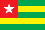
Flag description
five equal horizontal bands of green (top and bottom) alternating with yellow; a white five-pointed star on a red square is in the upper hoist-side corner; the five horizontal stripes stand for the five different regions of the country; the red square is meant to express the loyalty and patriotism of the people; green symbolizes hope, fertility, and agriculture; yellow represents mineral wealth and faith that hard work and strength will bring prosperity; the star symbolizes life, purity, peace, dignity, and Togo's independence uses the popular Pan-African colors of Ethiopia
Government type
republic under transition to multiparty democratic rule
Independence
27 April 1960 (from French-administered UN trusteeship)
International law organization participation
accepts compulsory ICJ jurisdiction with reservations; non-party state to the ICCt
International organization participation
ACP, AfDB, AU, ECOWAS, Entente, FAO, FZ, G-77, IAEA, IBRD, ICAO, ICC, ICRM, IDA, IDB, IFAD, IFC, IFRCS, ILO, IMF, IMO, Interpol, IOC, IOM, IPU, ITSO, ITU, ITUC, MIGA, NAM, OIC, OIF, OPCW, PCA, UN, UNAMID, UNCTAD, UNESCO, UNHCR, UNIDO, UNMIL, UNOCI, UNWTO, UPU, WADB (regional), WAEMU, WCO, WFTU, WHO, WIPO, WMO, WTO
Judicial branch
Court of Appeal or Cour d'Appel; Supreme Court or Cour Supreme
Legal system
customary law system
Legislative branch
- unicameral National Assembly (81 seats; members elected by popular vote to serve five-year terms) last held on 14 October 2007 (next to be held in 2012) percent of vote by party - RPT 39.4%, UFC 37.0%, CAR 8.2%, independents 2.5%, other 12.9%; seats by party - RPT 50, UFC 27, CAR 4
- election results
- percent of vote by party - RPT 39.4%, UFC 37.0%, CAR 8.2%, independents 2.5%, other 12.9%; seats by party - RPT 50, UFC 27, CAR 4
- elections
- last held on 14 October 2007 (next to be held in 2012)
National anthem
- "Salut a toi, pays de nos aieux" (Hail to Thee, Land of Our Forefathers) Alex CASIMIR-DOSSEH adopted 1960, restored 1992; this anthem was replaced by another during one-party rule between 1979 and 1992
- lyrics/music
- Alex CASIMIR-DOSSEH
- name
- "Salut a toi, pays de nos aieux" (Hail to Thee, Land of Our Forefathers)
National holiday
Independence Day, 27 April (1960)
Political parties and leaders
Action Committee for Renewal or CAR [Yawovi AGBOYIBO]; Democratic Convention of African Peoples or CDPA; Democratic Party for Renewal or PDR; Juvento [Monsilia DJATO]; Movement of the Believers of Peace and Equality or MOCEP; National Alliance for Change or ANC [Jean-Pierre FABRE]; Pan-African Patriotic Convergence or CPP; Rally for the Support for Development and Democracy or RSDD [Harry OLYMPIO]; Rally of the Togolese People or RPT [Faure GNASSINGBE]; Socialist Pact for Renewal or PSR; Union for Democracy and Social Progress or UDPS [Gagou KOKOU]; Union of Forces for Change or UFC [Gilchrist OLYMPIO]
Political pressure groups and leaders
NA
Suffrage
18 years of age; universal
Economy
Agriculture - products
coffee, cocoa, cotton, yams, cassava (tapioca), corn, beans, rice, millet, sorghum; livestock; fish
Budget
- $653 million $703.8 million (2010 est.)
- expenditures
- $703.8 million (2010 est.)
- revenues
- $653 million
Budget surplus (+) or deficit (-)
-1.6% of GDP (2010 est.)
Central bank discount rate
2.5% (31 December 2010 est.) 4.25% (31 December 2009 est.)
Commercial bank prime lending rate
NA%
Current account balance
-$244 million (2010 est.) -$223 million (2009 est.)
Debt - external
$NA (31 December 2010) $1.64 billion (31 December 2009 est.)
Economy - overview
This small, sub-Saharan economy suffers from anemic economic growth and depends heavily on both commercial and subsistence agriculture, which provides employment for 65% of the labor force. Some basic foodstuffs must still be imported. Cocoa, coffee, and cotton generate about 40% of export earnings with cotton being the most important cash crop. Togo is the world's fourth-largest producer of phosphate. The government's decade-long effort, supported by the World Bank and the IMF, to implement economic reform measures, encourage foreign investment, and bring revenues in line with expenditures has moved slowly. Progress depends on follow through on privatization, increased openness in government financial operations, progress toward legislative elections, and continued support from foreign donors. Togo is on track with its IMF Extended Credit Facility and reached a HIPC debt relief completion point in 2010 at which 95% of the country's debt was forgiven. Economic growth prospects remain marginal due to declining cotton production and underinvestment in phosphate mining.
Electricity - consumption
671.9 million kWh (2008 est.)
Electricity - exports
0 kWh (2009 est.)
Electricity - imports
666 million kWh; note - electricity supplied by Ghana (2008 est.)
Electricity - production
156.9 million kWh (2008 est.)
Exchange rates
Communaute Financiere Africaine francs (XOF) per US dollar - 495.28 (2010) 472.19 (2009) 447.81 (2008) 482.71 (2007) 522.59 (2006)
Exports
$840 million (2010 est.) $826 million (2009 est.)
Exports - commodities
reexports, cotton, phosphates, coffee, cocoa
Exports - partners
India 12.7%, Germany 12.2%, Benin 9.8%, Ghana 9.7%, Burkina Faso 9.1%, China 5.1%, Belgium 4.9%, Niger 4.6%, Nigeria 4.3% (2010)
GDP - composition by sector
- 46.1% 23.6% 34.1% (2010 est.)
- agriculture
- 46.1%
- industry
- 23.6%
- services
- 34.1% (2010 est.)
GDP - per capita (PPP)
$900 (2010 est.) $900 (2009 est.) $900 (2008 est.) data are in 2010 US dollars
GDP - real growth rate
3.4% (2010 est.) 3.2% (2009 est.) 2.4% (2008 est.)
GDP (official exchange rate)
$3.194 billion (2010 est.)
GDP (purchasing power parity)
$5.974 billion (2010 est.) $5.778 billion (2009 est.) $5.596 billion (2008 est.) data are in 2010 US dollars
Household income or consumption by percentage share
- 3.3% 27.1% (2006)
- highest 10%
- 27.1% (2006)
- lowest 10%
- 3.3%
Imports
$1.292 billion (2010 est.) $1.205 billion (2009 est.)
Imports - commodities
machinery and equipment, foodstuffs, petroleum products
Imports - partners
China 48%, France 8.3%, US 6.1% (2010)
Industrial production growth rate
2.5% (2010 est.)
Industries
phosphate mining, agricultural processing, cement, handicrafts, textiles, beverages
Inflation rate (consumer prices)
1.4% (2010 est.) 2% (2009 est.)
Investment (gross fixed)
18% of GDP (2010 est.)
Labor force
2.595 million (2007)
Labor force - by occupation
- 65% 5% 30% (1998 est.)
- agriculture
- 65%
- industry
- 5%
- services
- 30% (1998 est.)
Market value of publicly traded shares
$NA
Natural gas - consumption
0 cu m (2009 est.)
Natural gas - exports
0 cu m (2009 est.)
Natural gas - imports
0 cu m (2009 est.)
Natural gas - production
0 cu m (2009 est.)
Natural gas - proved reserves
0 cu m (1 January 2011 est.)
Oil - consumption
23,000 bbl/day (2010 est.)
Oil - exports
0 bbl/day (2009 est.)
Oil - imports
15,900 bbl/day (2009 est.)
Oil - production
0 bbl/day (2010 est.)
Oil - proved reserves
0 bbl (1 January 2010 est.)
Population below poverty line
32% (1989 est.)
Reserves of foreign exchange and gold
$669.4 million (31 December 2010 est.) $703.2 million (31 December 2009 est.)
Stock of broad money
$1.267 billion (31 December 2010 est.) $1.354 billion (31 December 2009 est.)
Stock of domestic credit
$836.4 million (31 December 2010 est.) $894.3 million (31 December 2009 est.)
Stock of narrow money
$777.9 million (31 December 2010 est.) $818.9 million (31 December 2009 est.)
Taxes and other revenues
20.4% of GDP (2010 est.)
Unemployment rate
NA%
Communications
Broadcast media
2 state-owned TV stations with multiple transmission sites; 5 private TV stations broadcast locally; cable TV service is available; state-owned radio network with multiple stations; several dozen private radio stations and a few community radio stations; transmissions of multiple international broadcasters are obtainable (2007)
Internet country code
.tg
Internet hosts
860 (2010)
Internet users
356,300 (2009)
Telephone system
- fair system based on a network of microwave radio relay routes supplemented by open-wire lines and a mobile-cellular system microwave radio relay and open-wire lines for conventional system; combined fixed-line and mobile-cellular teledensity roughly 40 telephones per 100 persons with mobile-cellular use predominating country code - 228; satellite earth stations - 1 Intelsat (Atlantic Ocean), 1 Symphonie
- domestic
- microwave radio relay and open-wire lines for conventional system; combined fixed-line and mobile-cellular teledensity roughly 40 telephones per 100 persons with mobile-cellular use predominating
- general assessment
- fair system based on a network of microwave radio relay routes supplemented by open-wire lines and a mobile-cellular system
- international
- country code - 228; satellite earth stations - 1 Intelsat (Atlantic Ocean), 1 Symphonie
Telephones - main lines in use
213,800 (2010)
Telephones - mobile cellular
2.452 million (2010)
Transportation
Airports
8 (2010)
Airports - with paved runways
- 2 (2010)
- 2,438 to 3,047 m
- 2 (2010)
- total
- 2
Airports - with unpaved runways
- 2 (2010)
- 914 to 1,523 m
- 4
- total
- 6
- under 914 m
- 2 (2010)
Merchant marine
- bulk carrier 5, cargo 40, chemical tanker 2, container 2, petroleum tanker 2, refrigerated cargo 1, roll on/roll off 1 23 (China 2, Greece 1, Lebanon 6, Romania 1, Syria 5, Turkey 4, UAE 1, UK 3) (2010)
- foreign-owned
- 23 (China 2, Greece 1, Lebanon 6, Romania 1, Syria 5, Turkey 4, UAE 1, UK 3) (2010)
- total
- 53
Ports and terminals
Kpeme, Lome
Railways
- 568 km 568 km 1.000-m gauge (2010)
- total
- 568 km
Roadways
- 7,520 km 2,376 km 5,144 km (2007)
- total
- 7,520 km
- unpaved
- 5,144 km (2007)
Waterways
50 km (seasonally navigable by small craft on the Mono River depending on rainfall) (2009)
Military and Security
Manpower available for military service
- 1,577,572 1,589,715 (2010 est.)
- females age 16-49
- 1,589,715 (2010 est.)
- males age 16-49
- 1,577,572
Manpower fit for military service
- 1,104,536 1,158,061 (2010 est.)
- females age 16-49
- 1,158,061 (2010 est.)
- males age 16-49
- 1,104,536
Manpower reaching militarily significant age annually
- 74,036 73,515 (2010 est.)
- female
- 73,515 (2010 est.)
- male
- 74,036
Military branches
- Togolese Armed Forces (Forces Armees Togolaise, FAT): Ground Forces, Togolese Navy (Marine du Togo), Togolese Air Force (Force Aerienne Togolaise, TAF), National Gendarmerie (2011)
- Togolese Armed Forces (Forces Armees Togolaise, FAT)
- Ground Forces, Togolese Navy (Marine du Togo), Togolese Air Force (Force Aerienne Togolaise, TAF), National Gendarmerie (2011)
Military expenditures
1.6% of GDP (2005 est.)
Military service age and obligation
18 years of age for selective compulsory military service; 2-year service obligation (2011)
Transnational Issues
Disputes - international
in 2001, Benin claimed Togo moved boundary monuments - joint commission continues to resurvey the boundary; in 2006, 14,000 Togolese refugees remain in Benin and Ghana out of the 40,000 who fled there in 2005; talks continue between Benin and Togo on funding the Adjrala hydroelectric dam on the Mona River
Illicit drugs
transit hub for Nigerian heroin and cocaine traffickers; money laundering not a significant problem
Refugees and internally displaced persons
- 5,000 (Ghana) 1,500 (2007)
- IDPs
- 1,500 (2007)
- refugees (country of origin)
- 5,000 (Ghana)