2013 Edition
CIA World Factbook 2013 Archive (HTML)
Introduction
Background
Lucayan Indians inhabited the islands when Christopher COLUMBUS first set foot in the New World on San Salvador in 1492. British settlement of the islands began in 1647; the islands became a colony in 1783. Since attaining independence from the UK in 1973, The Bahamas has prospered through tourism, international banking, and investment management. Because of its geography, the country is a major transshipment point for illegal drugs, particularly shipments to the US and Europe, and its territory is used for smuggling illegal migrants into the US.
Geography
Area
- 13,880 sq km 10,010 sq km 3,870 sq km
- total
- 13,880 sq km
- water
- 3,870 sq km
Area - comparative
slightly smaller than Connecticut
Climate
tropical marine; moderated by warm waters of Gulf Stream
Coastline
3,542 km
Elevation extremes
- Atlantic Ocean 0 m Mount Alvernia on Cat Island 63 m
- highest point
- Mount Alvernia on Cat Island 63 m
- lowest point
- Atlantic Ocean 0 m
Environment - current issues
coral reef decay; solid waste disposal
Environment - international agreements
- Biodiversity, Climate Change, Climate Change-Kyoto Protocol, Desertification, Endangered Species, Hazardous Wastes, Law of the Sea, Ozone Layer Protection, Ship Pollution, Wetlands none of the selected agreements
- party to
- Biodiversity, Climate Change, Climate Change-Kyoto Protocol, Desertification, Endangered Species, Hazardous Wastes, Law of the Sea, Ozone Layer Protection, Ship Pollution, Wetlands
- signed, but not ratified
- none of the selected agreements
Geographic coordinates
24 15 N, 76 00 W
Geography - note
strategic location adjacent to US and Cuba; extensive island chain of which 30 are inhabited
Irrigated land
10 sq km (2003)
Land boundaries
0 km
Land use
- 0.65% 0.29% 99.06% (2011)
- arable land
- 0.65%
- other
- 99.06% (2011)
- permanent crops
- 0.29%
Location
chain of islands in the North Atlantic Ocean, southeast of Florida, northeast of Cuba
Map references
Central America and the Caribbean
Maritime claims
- 12 nm 200 nm
- exclusive economic zone
- 200 nm
- territorial sea
- 12 nm
Natural hazards
hurricanes and other tropical storms cause extensive flood and wind damage
Natural resources
salt, aragonite, timber, arable land
Terrain
long, flat coral formations with some low rounded hills
Total renewable water resources
0.02 cu km (2011)
People and Society
Age structure
- 23.6% (male 38,174/female 37,066) 17.5% (male 28,306/female 27,562) 44.1% (male 70,093/female 70,608) 8.1% (male 11,371/female 14,355) 6.7% (male 8,233/female 13,263) (2013 est.)
- 0-14 years
- 23.6% (male 38,174/female 37,066)
- 15-24 years
- 17.5% (male 28,306/female 27,562)
- 25-54 years
- 44.1% (male 70,093/female 70,608)
- 55-64 years
- 8.1% (male 11,371/female 14,355)
- 65 years and over
- 6.7% (male 8,233/female 13,263) (2013 est.)
Birth rate
15.81 births/1,000 population (2013 est.)
Death rate
6.96 deaths/1,000 population (2013 est.)
Dependency ratios
- 40.9 % 30 % 10.8 % 9.2 (2013)
- elderly dependency ratio
- 10.8 %
- potential support ratio
- 9.2 (2013)
- total dependency ratio
- 40.9 %
- youth dependency ratio
- 30 %
Drinking water source
- urban: 98% of population rural: 86% of population total: 96% of population urban: 2% of population rural: 14% of population total: 4% of population (2000 est.)
- rural
- 14% of population
- total
- 4% of population (2000 est.)
- urban
- 2% of population
Education expenditures
NA
Ethnic groups
black 85%, white 12%, Asian and Hispanic 3%
Health expenditures
7.7% of GDP (2011)
HIV/AIDS - adult prevalence rate
3.1% (2009 est.)
HIV/AIDS - deaths
fewer than 500 (2009 est.)
HIV/AIDS - people living with HIV/AIDS
6,600 (2009 est.)
Hospital bed density
3.1 beds/1,000 population (2010)
Infant mortality rate
- 12.89 deaths/1,000 live births 12.9 deaths/1,000 live births 12.88 deaths/1,000 live births (2013 est.)
- female
- 12.88 deaths/1,000 live births (2013 est.)
- total
- 12.89 deaths/1,000 live births
Languages
English (official), Creole (among Haitian immigrants)
Life expectancy at birth
- 71.69 years 69.25 years 74.19 years (2013 est.)
- female
- 74.19 years (2013 est.)
- total population
- 71.69 years
Literacy
- age 15 and over can read and write 95.6% 94.7% 96.5% (2003 est.)
- definition
- age 15 and over can read and write
- female
- 96.5% (2003 est.)
- male
- 94.7%
- total population
- 95.6%
Major urban areas - population
NASSAU (capital) 254,000 (2011)
Maternal mortality rate
47 deaths/100,000 live births (2010)
Median age
- 30.8 years 29.7 years 32 years (2013 est.)
- female
- 32 years (2013 est.)
- male
- 29.7 years
- total
- 30.8 years
Nationality
- Bahamian(s) Bahamian
- adjective
- Bahamian
- noun
- Bahamian(s)
Net migration rate
0 migrant(s)/1,000 population (2013 est.)
Obesity - adult prevalence rate
34.7% (2008)
Physicians density
2.82 physicians/1,000 population (2008)
Population
319,031 (July 2013 est.) estimates for this country explicitly take into account the effects of excess mortality due to AIDS; this can result in lower life expectancy, higher infant mortality, higher death rates, lower population growth rates, and changes in the distribution of population by age and sex than would otherwise be expected
Population growth rate
0.89% (2013 est.)
Religions
Protestant 67.6% (Baptist 35.4%, Anglican 15.1%, Pentecostal 8.1%, Church of God 4.8%, Methodist 4.2%), Roman Catholic 13.5%, other Christian 15.2%, none or unspecified 2.9%, other 0.8% (2000 census)
Sanitation facility access
- urban: 100% of population rural: 100% of population total: 100% of population (2010 est.)
- rural
- 100% of population
- total
- 100% of population (2010 est.)
- urban
- 100% of population
School life expectancy (primary to tertiary education)
- 12 years 12 years 12 years (2006)
- female
- 12 years (2006)
- male
- 12 years
- total
- 12 years
Sex ratio
- 1.03 male(s)/female 1.03 male(s)/female 1.03 male(s)/female 0.99 male(s)/female 0.79 male(s)/female 0.62 male(s)/female 0.96 male(s)/female (2013 est.)
- 0-14 years
- 1.03 male(s)/female
- 15-24 years
- 1.03 male(s)/female
- 25-54 years
- 0.99 male(s)/female
- 55-64 years
- 0.79 male(s)/female
- 65 years and over
- 0.62 male(s)/female
- at birth
- 1.03 male(s)/female
- total population
- 0.96 male(s)/female (2013 est.)
Total fertility rate
1.97 children born/woman (2013 est.)
Unemployment, youth ages 15-24
- 18.9% 16.7% 21.7% (2007)
- female
- 21.7% (2007)
- total
- 18.9%
Urbanization
- 84% of total population (2010) 1.3% annual rate of change (2010-15 est.)
- rate of urbanization
- 1.3% annual rate of change (2010-15 est.)
- urban population
- 84% of total population (2010)
Government
Administrative divisions
31 districts; Acklins Islands, Berry Islands, Bimini, Black Point, Cat Island, Central Abaco, Central Andros, Central Eleuthera, City of Freeport, Crooked Island and Long Cay, East Grand Bahama, Exuma, Grand Cay, Harbour Island, Hope Town, Inagua, Long Island, Mangrove Cay, Mayaguana, Moore's Island, North Abaco, North Andros, North Eleuthera, Ragged Island, Rum Cay, San Salvador, South Abaco, South Andros, South Eleuthera, Spanish Wells, West Grand Bahama
Capital
- Nassau 25 05 N, 77 21 W UTC-5 (same time as Washington, DC during Standard Time) +1hr, begins second Sunday in March; ends first Sunday in November
- daylight saving time
- +1hr, begins second Sunday in March; ends first Sunday in November
- geographic coordinates
- 25 05 N, 77 21 W
- name
- Nassau
- time difference
- UTC-5 (same time as Washington, DC during Standard Time)
Constitution
previous 1964 (preindependence); latest adopted 20 June 1973, effective 10 July 1973; amended many times, last in 2002; note - in 2012, a constitutional commission was appointed to review and recommend constitutional changes (2013)
Country name
- Commonwealth of The Bahamas The Bahamas
- conventional long form
- Commonwealth of The Bahamas
- conventional short form
- The Bahamas
Diplomatic representation from the US
- Ambassador (vacant); Charge d' Affaires John DINKELMAN (since November 2011) 42 Queen Street, Nassau, New Providence local or express mail address: P. O. Box N-8197, Nassau; US Department of State, 3370 Nassau Place, Washington, DC 20521-3370 [1] (242) 322-1181, 328-2206 (after hours) [1] (242) 328-2206
- chief of mission
- Ambassador (vacant); Charge d' Affaires John DINKELMAN (since November 2011)
- embassy
- 42 Queen Street, Nassau, New Providence
- FAX
- [1] (242) 328-2206
- mailing address
- local or express mail address: P. O. Box N-8197, Nassau; US Department of State, 3370 Nassau Place, Washington, DC 20521-3370
- telephone
- [1] (242) 322-1181, 328-2206 (after hours)
Diplomatic representation in the US
- Ambassador Dr. Eugene Glenwood NEWRY (since 3 December 2013) 2220 Massachusetts Avenue NW, Washington, DC 20008 [1] (202) 319-2660 [1] (202) 319-2668 Atlanta, Miami, New York
- chancery
- 2220 Massachusetts Avenue NW, Washington, DC 20008
- chief of mission
- Ambassador Dr. Eugene Glenwood NEWRY (since 3 December 2013)
- consulate(s) general
- Atlanta, Miami, New York
- FAX
- [1] (202) 319-2668
- telephone
- [1] (202) 319-2660
Executive branch
- Queen ELIZABETH II (since 6 February 1952); represented by Governor General Sir Arthur A. FOULKES (since 14 April 2010) Prime Minister Perry CHRISTIE (since 8 May 2012) Cabinet appointed by the governor general on the prime minister's recommendation the monarchy is hereditary; governor general appointed by the monarch; following legislative elections, the leader of the majority party or the leader of the majority coalition is usually appointed prime minister by the governor general; the prime minister recommends the deputy prime minister
- cabinet
- Cabinet appointed by the governor general on the prime minister's recommendation
- chief of state
- Queen ELIZABETH II (since 6 February 1952); represented by Governor General Sir Arthur A. FOULKES (since 14 April 2010)
- elections
- the monarchy is hereditary; governor general appointed by the monarch; following legislative elections, the leader of the majority party or the leader of the majority coalition is usually appointed prime minister by the governor general; the prime minister recommends the deputy prime minister
- head of government
- Prime Minister Perry CHRISTIE (since 8 May 2012)
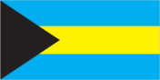
Flag description
three equal horizontal bands of aquamarine (top), gold, and aquamarine, with a black equilateral triangle based on the hoist side; the band colors represent the golden beaches of the islands surrounded by the aquamarine sea; black represents the vigor and force of a united people, while the pointing triangle indicates the enterprise and determination of the Bahamian people to develop the rich resources of land and sea
Government type
constitutional parliamentary democracy and a Commonwealth realm
Independence
10 July 1973 (from the UK)
International law organization participation
has not submitted an ICJ jurisdiction declaration; non-party state to the ICCt
International organization participation
ACP, AOSIS, C, Caricom, CDB, CELAC, FAO, G-77, IADB, IBRD, ICAO, ICRM, IDA, IFAD, IFC, IFRCS, ILO, IMF, IMO, IMSO, Interpol, IOC, IOM, ITSO, ITU, LAES, MIGA, NAM, OAS, OPANAL, OPCW, Petrocaribe, UN, UNCTAD, UNESCO, UNIDO, UNWTO, UPU, WCO, WHO, WIPO, WMO, WTO (observer)
Judicial branch
- The Bahamas Court of Appeal (consists of the court president and 4 justices, sitting in panels of 3 justices) note - as of 2008, the Bahamas was not a party to the agreement establishing the Caribbean Court of Justice as the highest appellate court for the 15-member Caribbean Community (CARICOM); the Judicial Committee of the Privy Council (in London) serves as the final court of appeal for the Bahamas Court of Appeal justices appointed by the governor-general on the advice of the prime minister and in consultation with the Judicial and Legal Services Commission; justices appointed for life with mandatory retirement at age 68-70 Supreme Court; Industrial Tribunal; Stipendiary and Magistrates Courts; Family Island Administrators
- highest court(s)
- The Bahamas Court of Appeal (consists of the court president and 4 justices, sitting in panels of 3 justices)
- judge selection and term of office
- Court of Appeal justices appointed by the governor-general on the advice of the prime minister and in consultation with the Judicial and Legal Services Commission; justices appointed for life with mandatory retirement at age 68-70
- subordinate courts
- Supreme Court; Industrial Tribunal; Stipendiary and Magistrates Courts; Family Island Administrators
Legal system
common law system based on the English model
Legislative branch
- bicameral Parliament consists of the Senate (16 seats; members appointed by the governor general upon the advice of the prime minister and the opposition leader to serve five-year terms) and the House of Assembly (38 seats; members elected by direct popular vote to serve five-year terms); the government may dissolve the parliament and call elections at any time last held on 7 May 2012 (next to be held by May 2017) percent of vote by party - NA; seats by party - PLP 30, FNM 8
- election results
- percent of vote by party - NA; seats by party - PLP 30, FNM 8
- elections
- last held on 7 May 2012 (next to be held by May 2017)
National anthem
- "March On, Bahamaland!" Timothy GIBSON adopted 1973; as a Commonwealth country, in addition to the national anthem, "God Save the Queen" serves as the royal anthem (see United Kingdom)
- lyrics/music
- Timothy GIBSON
- name
- "March On, Bahamaland!"
National holiday
Independence Day, 10 July (1973)
National symbol(s)
blue marlin; flamingo
Political parties and leaders
Free National Movement or FNM [Hubert MINNIS] Progressive Liberal Party or PLP [Perry CHRISTIE]
Political pressure groups and leaders
- Friends of the Environment trade unions
- other
- trade unions
Suffrage
18 years of age; universal
Economy
Agriculture - products
citrus, vegetables; poultry
Budget
- $1.54 billion $2.04 billion (2012 est.)
- expenditures
- $2.04 billion (2012 est.)
- revenues
- $1.54 billion
Budget surplus (+) or deficit (-)
-6.2% of GDP (2012 est.)
Central bank discount rate
4.5% (31 December 2012 est.) 4% (31 December 2011 est.)
Commercial bank prime lending rate
4.75% (31 December 2012 est.) 5.06% (31 December 2011 est.)
Current account balance
$-1.424 billion (2012 est.) $-1.136 billion (2011 est.)
Debt - external
$16.35 billion (31 December 2012 est.) $15.13 billion (31 December 2011 est.)
Economy - overview
The Bahamas is one of the wealthiest Caribbean countries with an economy heavily dependent on tourism and offshore banking. Tourism together with tourism-driven construction and manufacturing accounts for approximately 60% of GDP and directly or indirectly employs half of the archipelago's labor force. Financial services constitute the second-most important sector of the Bahamian economy and, when combined with business services, account for about 36% of GDP. Manufacturing and agriculture combined contribute less than a 10th of GDP and show little growth, despite government incentives aimed at those sectors. The economy of The Bahamas shrank at an average pace of 0.8% annually between 2007-11, and tourism, financial services, and construction - pillars of the national economy - remained weak. These challenges, coupled with a growing public debt, increases in government expenditures, a narrow revenue base, and heavy dependence on customs and property taxes have led to prospects of limited growth for The Bahamas.
Exchange rates
Bahamian dollars (BSD) per US dollar - 1 (2012 est.) 1 (2011 est.) 1 (2010 est.) 1 (2008 est.) 1 (2007 est.)
Exports
$984 million (2012 est.) $833.5 million (2011 est.)
Exports - commodities
crawfish, aragonite, crude salt, polystyrene products
Exports - partners
Singapore 25.1%, US 20.6%, Dominican Republic 12.9%, Ecuador 9.4%, Canada 5.8%, Switzerland 4.1%, China 4.1% (2012)
Fiscal year
1 July - 30 June
GDP - composition, by end use
- 70.1% 14.9% 31.9% 1.3% 44.8% -62.9% (2012 est.)
- exports of goods and services
- 44.8%
- government consumption
- 14.9%
- household consumption
- 70.1%
- imports of goods and services
- -62.9%
- investment in fixed capital
- 31.9%
- investment in inventories
- 1.3%
GDP - composition, by sector of origin
- 2.1% 7.2% 90.7% (2012 est.)
- agriculture
- 2.1%
- industry
- 7.2%
- services
- 90.7% (2012 est.)
GDP - per capita (PPP)
$31,300 (2012 est.) $31,100 (2011 est.) $30,900 (2010 est.) data are in 2012 US dollars
GDP - real growth rate
1.8% (2012 est.) 1.7% (2011 est.) 1% (2010 est.)
GDP (official exchange rate)
$8.039 billion (2012 est.)
GDP (purchasing power parity)
$11.04 billion (2012 est.) $10.84 billion (2011 est.) $10.66 billion (2010 est.) data are in 2012 US dollars
Household income or consumption by percentage share
- 1% 22% (2007 est.)
- highest 10%
- 22% (2007 est.)
- lowest 10%
- 1%
Imports
$3.386 billion (2012 est.) $2.966 billion (2011 est.)
Imports - commodities
machinery and transport equipment, manufactures, chemicals, mineral fuels; food and live animals
Imports - partners
US 30.1%, India 20.3%, Singapore 8.7%, South Korea 6.8%, China 5%, Colombia 4.5%, Canada 4.2% (2012)
Industrial production growth rate
NA%
Industries
tourism, banking, cement, oil transshipment, salt, rum, aragonite, pharmaceuticals
Inflation rate (consumer prices)
2% (2012 est.) 3.2% (2011 est.)
Labor force
192,200 (2012)
Labor force - by occupation
- 5% 5% 50% 40% (2005 est.)
- agriculture
- 5%
- industry
- 5%
- other services
- 40% (2005 est.)
- tourism
- 50%
Market value of publicly traded shares
$2.78 billion (31 December 2012 est.)
Population below poverty line
9.3% (2004)
Reserves of foreign exchange and gold
$846.9 million (31 December 2012 est.) $1.07 billion (31 December 2011 est.)
Stock of broad money
$6.482 billion (31 December 2012 est.) $6.104 billion (31 December 2011 est.)
Stock of domestic credit
$8.653 billion (31 December 2012 est.) $8.511 billion (31 December 2011 est.)
Stock of narrow money
$1.575 billion (31 December 2012 est.) $1.435 billion (31 December 2011 est.)
Taxes and other revenues
19.2% of GDP (2012 est.)
Unemployment rate
14% (2012 est.) 14.2% (2009 est.)
Energy
Carbon dioxide emissions from consumption of energy
4.734 million Mt (2011 est.)
Crude oil - exports
0 bbl/day (2010 est.)
Crude oil - imports
0 bbl/day (2010 est.)
Crude oil - production
0 bbl/day (2012 est.)
Crude oil - proved reserves
0 bbl (1 January 2013 es)
Electricity - consumption
1.795 billion kWh (2010 est.)
Electricity - exports
0 kWh (2012 est.)
Electricity - from fossil fuels
100% of total installed capacity (2012 est.)
Electricity - from hydroelectric plants
0% of total installed capacity (2012 est.)
Electricity - from nuclear fuels
0% of total installed capacity (2012 est.)
Electricity - from other renewable sources
0% of total installed capacity (2012 est.)
Electricity - imports
0 kWh (2012 est.)
Electricity - installed generating capacity
493,000 kW (2010 est.)
Electricity - production
1.93 billion kWh (2010 est.)
Natural gas - consumption
0 cu m (2010 est.)
Natural gas - exports
0 cu m (2011 est.)
Natural gas - imports
0 cu m (2011 est.)
Natural gas - production
0 cu m (2011 est.)
Natural gas - proved reserves
0 cu m (1 January 2009 es)
Refined petroleum products - consumption
36,300 bbl/day (2011 est.)
Refined petroleum products - exports
41,770 bbl/day (2010 est.)
Refined petroleum products - imports
64,600 bbl/day (2010 est.)
Refined petroleum products - production
0 bbl/day (2010 est.)
Communications
Broadcast media
2 TV stations operated by government-owned, commercially run Broadcasting Corporation of the Bahamas (BCB); multi-channel cable TV subscription service is available; about 15 radio stations operating with BCB operating a multi-channel radio broadcasting network alongside privately owned radio stations (2007)
Internet country code
.bs
Internet hosts
20,661 (2012)
Internet users
115,800 (2009)
Telephone system
- modern facilities totally automatic system; highly developed; the Bahamas Domestic Submarine Network links 14 of the islands and is designed to satisfy increasing demand for voice and broadband Internet services country code - 1-242; landing point for the Americas Region Caribbean Ring System (ARCOS-1) fiber-optic submarine cable that provides links to South and Central America, parts of the Caribbean, and the US; satellite earth stations - 2 (2007)
- domestic
- totally automatic system; highly developed; the Bahamas Domestic Submarine Network links 14 of the islands and is designed to satisfy increasing demand for voice and broadband Internet services
- general assessment
- modern facilities
- international
- country code - 1-242; landing point for the Americas Region Caribbean Ring System (ARCOS-1) fiber-optic submarine cable that provides links to South and Central America, parts of the Caribbean, and the US; satellite earth stations - 2 (2007)
Telephones - main lines in use
137,000 (2012)
Telephones - mobile cellular
254,000 (2012)
Transportation
Airports
61 (2013)
Airports - with paved runways
- 7 (2013)
- 1,524 to 2,437 m
- 13
- 2,438 to 3,047 m
- 2
- 914 to 1,523 m
- 7 (2013)
- over 3,047 m
- 2
- total
- 24
Airports - with unpaved runways
- 17 (2013)
- 1,524 to 2,437 m
- 4
- 914 to 1,523 m
- 16
- total
- 37
Heliports
1 (2013)
Merchant marine
- 1,160 barge carrier 1, bulk carrier 238, cargo 170, carrier 2, chemical tanker 87, combination ore/oil 8, container 57, liquefied gas 71, passenger 102, passenger/cargo 26, petroleum tanker 225, refrigerated cargo 97, roll on/roll off 13, specialized tanker 2, vehicle carrier 61 1,063 (Angola 6, Australia 1, Belgium 6, Bermuda 15, Brazil 1, Canada 96, Croatia 1, Cyprus 23, Denmark 69, Finland 8, France 15, Germany 30, Greece 225, Guernsey 6, Hong Kong 3, Indonesia 2, Ireland 3, Italy 1, Japan 88, Jordan 2, Kuwait 1, Malaysia 13, Monaco 8, Montenegro 2, Netherlands 23, Nigeria 2, Norway 186, Poland 34, Saudi Arabia 16, Singapore 7, South Korea 1, Spain 6, Sweden 11, Switzerland 1, Thailand 4, Turkey 3, UAE 23, UK 18, US 109) 6 (Panama 6) (2010)
- foreign-owned
- 1,063 (Angola 6, Australia 1, Belgium 6, Bermuda 15, Brazil 1, Canada 96, Croatia 1, Cyprus 23, Denmark 69, Finland 8, France 15, Germany 30, Greece 225, Guernsey 6, Hong Kong 3, Indonesia 2, Ireland 3, Italy 1, Japan 88, Jordan 2, Kuwait 1, Malaysia 13, Monaco 8, Montenegro 2, Netherlands 23, Nigeria 2, Norway 186, Poland 34, Saudi Arabia 16, Singapore 7, South Korea 1, Spain 6, Sweden 11, Switzerland 1, Thailand 4, Turkey 3, UAE 23, UK 18, US 109)
- registered in other countries
- 6 (Panama 6) (2010)
- total
- 1,160
Ports and terminals
- Freeport, Nassau, South Riding Point Freeport (1,116,272)(2011) Nassau
- container port(s) (TEUs)
- Freeport (1,116,272)(2011)
- cruise port(s)
- Nassau
- major seaport(s)
- Freeport, Nassau, South Riding Point
Roadways
- 2,700 km 1,620 km 1,080 km (2011)
- total
- 2,700 km
- unpaved
- 1,080 km (2011)
Military and Security
Manpower available for military service
- 85,568 (2010 est.)
- males age 16-49
- 85,568 (2010 est.)
Manpower fit for military service
- 63,429 64,645 (2010 est.)
- females age 16-49
- 64,645 (2010 est.)
- males age 16-49
- 63,429
Manpower reaching militarily significant age annually
- 2,829 2,750 (2010 est.)
- female
- 2,750 (2010 est.)
- male
- 2,829
Military branches
- Royal Bahamas Defense Force: Land Force, Navy, Air Wing (2011)
- Royal Bahamas Defense Force
- Land Force, Navy, Air Wing (2011)
Military expenditures
0.6% of GDP (2011)
Military service age and obligation
18 years of age for voluntary male and female service; no conscription (2012)
Transnational Issues
Disputes - international
disagrees with the US on the alignment of the northern axis of a potential maritime boundary
Illicit drugs
transshipment point for cocaine and marijuana bound for US and Europe; offshore financial center