1990 Edition
CIA World Factbook 1990 (Project Gutenberg)
Geography
Climate
tropical marine; moderated by warm waters of Gulf Stream
Coastline
3,542 km
Comparative area
slightly larger than Connecticut
Continental shelf
200 meters or to depth of exploitation;
Environment
subject to hurricanes and other tropical storms that cause extensive flood damage
Exclusive fishing zone
200 nm;
Land boundaries
none
Land use
1% arable land; NEGL% permanent crops; NEGL% meadows and pastures; 32% forest and woodland; 67% other
Natural resources
salt, aragonite, timber
Note
strategic location adjacent to US and Cuba; extensive island chain
Terrain
long, flat coral formations with some low rounded hills
Territorial sea
3 nm
Total area
13,940 km2; land area: 10,070 km2
People and Society
Birth rate
17 births/1,000 population (1990)
Death rate
6 deaths/1,000 population (1990)
Ethnic divisions
85% black, 15% white
Infant mortality rate
21 deaths/1,000 live births (1990)
Labor force
132,600; 30% government, 25% hotels and restaurants, 10% business services, 5% agriculture (1986)
Language
English; some Creole among Haitian immigrants
Life expectancy at birth
68 years male, 75 years female (1990)
Literacy
95% (1986)
Nationality
noun--Bahamian(s); adjective--Bahamian
Net migration rate
0 migrants/1,000 population (1990)
Organized labor
25% of labor force
Population
246,491 (July 1990), growth rate 1.2% (1990)
Religion
Baptist 29%, Anglican 23%, Roman Catholic 22%, smaller groups of other Protestants, Greek Orthodox, and Jews
Total fertility rate
1.9 children born/woman (1990)
Government
Administrative divisions
21 districts; Abaco, Acklins Island, Andros Island, Berry Islands, Biminis, Cat Island, Cay Lobos, Crooked Island, Eleuthera, Exuma, Grand Bahama, Harbour Island, Inagua, Long Cay, Long Island, Mayaguana, New Providence, Ragged Island, Rum Cay, San Salvador, Spanish Wells
Capital
Nassau
Communists
none known
Constitution
10 July 1973
Diplomatic representation
Ambassador Margaret E. MCDONALD; Chancery at Suite 865, 600 New Hampshire Avenue NW, Washington DC 20037; telephone (202) 944-3390; there are Bahamian Consulates General in Miami and New York; US--Ambassador Chic HECHT; Embassy at Mosmar Building, Queen Street, Nassau (mailing address is P. O. Box N-8197, Nassau); telephone (809) 322-1181 or 328-2206
Elections
House of Assembly--last held 19 June 1987 (next to be held by June 1992); results--percent of vote by party NA; seats--(49 total) PLP 31, FNM 16, independents 2
Executive branch
British monarch, governor general, prime minister, deputy prime minister, Cabinet
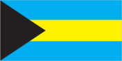
Flag
three equal horizontal bands of aquamarine (top), gold, and aquamarine with a black equilateral triangle based on the hoist side
Independence
10 July 1973 (from UK)
Judicial branch
Supreme Court
Leaders
Chief of State--Queen ELIZABETH II (since 6 February 1952), represented by Acting Governor General Sir Henry TAYLOR (since 26 June 1988); Head of Government--Prime Minister Sir Lynden Oscar PINDLING (since 16 January 1967)
Legal system
based on English common law
Legislative branch
bicameral Parliament consists of an upper house or Senate and a lower house or House of Assembly
Long-form name
The Commonwealth of The Bahamas
Member of
ACP, CARICOM, CCC, CDB, Commonwealth, FAO, G-77, GATT (de facto), IBRD, ICAO, IDB--Inter-American Development Bank, ILO, IMF, IMO, INTELSAT, INTERPOL, ITU, NAM, OAS, PAHO, UN, UNESCO, UPU, WHO, WIPO, WMO, WTO
National holiday
Independence Day, 10 July (1973)
Other political or pressure groups
Vanguard Nationalist and Socialist Party (VNSP), a small leftist party headed by Lionel Carey; Trade Union Congress (TUC), headed by Arlington Miller
Political parties and leaders
Progressive Liberal Party (PLP), Sir Lynden O. Pindling; Free National Movement (FNM), Cecil Wallace-Whitfield
Suffrage
universal at age 18
Type
commonwealth
Economy
Agriculture
accounts for less than 5% of GDP; dominated by small-scale producers; principal products--citrus fruit, vegetables, poultry; large net importer of food
Aid
US commitments, including Ex-Im (FY70-80), $42 million; Western (non-US) countries, ODA and OOF bilateral commitments (1970-87), $344 million
Budget
revenues $555 million; expenditures $702 million, including capital expenditures of $138 million (1989 est.)
Currency
Bahamian dollar (plural--dollars); 1 Bahamian dollar (B$) = 100 cents
Electricity
368,000 kW capacity; 857 million kWh produced, 3,470 kWh per capita (1989)
Exchange rates
Bahamian dollar (B$) per US$1--1.00 (fixed rate)
Exports
$733 million (f.o.b., 1987); commodities--pharmaceuticals, cement, rum, crawfish; partners--US 90%, UK 10%
External debt
$1.5 billion (September 1988)
Fiscal year
calendar year
GDP
$2.4 billion, per capita $9,875; real growth rate 2.0%
Imports
$1.7 billion (c.i.f., 1987); commodities--foodstuffs, manufactured goods, mineral fuels; partners--Iran 30%, Nigeria 20%, US 10%, EC 10%, Gabon 10%
Industrial production
growth rate NA%
Industries
banking, tourism, cement, oil refining and transshipment, salt production, rum, aragonite, pharmaceuticals, spiral weld, steel pipe
Inflation rate (consumer prices)
4.1% (1988)
Overview
The Bahamas is a stable, middle-income developing nation whose economy is based primarily on tourism and offshore banking. Tourism alone provides about 50% of GDP and directly or indirectly employs about 50,000 people or 40% of the local work force. The economy has boomed in recent years, aided by a steady annual increase in the number of tourists. The per capita GDP of over $9,800 is one of the highest in the region.
Unemployment
12% (1986)
Communications
Airports
59 total, 57 usable; 31 with permanent-surface runways; none with runways over 3,659 m; 3 with runways 2,440-3,659 m; 25 with runways 1,220-2,439 m
Civil air
9 major transport aircraft
Highways
2,400 km total; 1,350 km paved, 1,050 km gravel
Merchant marine
533 ships (1,000 GRT or over) totaling 11,684,123 GRT/19,574,532 DWT; includes 26 passenger, 15 short-sea passenger, 121 cargo, 40 roll-on/roll-off cargo, 42 refrigerated cargo, 16 container, 6 car carrier, 123 petroleum, oils, and lubricants (POL) tanker, 6 liquefied gas, 19 combination ore/oil, 29 chemical tanker, 1 specialized tanker, 86 bulk, 3 combination bulk; note--a flag of convenience registry
Ports
Freeport, Nassau
Telecommunications
highly developed; 99,000 telephones in totally automatic system; tropospheric scatter and submarine cable links to Florida; stations--3 AM, 2 FM, 1 TV; 3 coaxial submarine cables;1 Atlantic Ocean INTELSAT earth station
Military and Security
Branches
Royal Bahamas Defense Force (a coast guard element only), Royal Bahamas Police Force
Defense expenditures
NA
Military manpower
NA