1996 Edition
CIA World Factbook 1996 (Project Gutenberg)
Introduction
Description
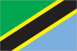
divided diagonally by a yellow-edged black band from the lower hoist-side corner; the upper triangle (hoist side) is green and the lower triangle is blue
Location
6 00 S, 35 00 E -- Eastern Africa, bordering the Indian Ocean, between Kenya and Mozambique Flag ----
Geography
Area
- comparative area
- slightly larger than twice the size of California
- land area
- 886,040 sq km
- note
- includes the islands of Mafia, Pemba, and Zanzibar
- total area
- 945,090 sq km
Climate
varies from tropical along coast to temperate in highlands
Coastline
1,424 km
Environment
- current issues
- soil degradation; deforestation; desertification; destruction of coral reefs threatens marine habitats; recent droughts affected marginal agriculture
- international agreements
- party to - Endangered Species, Hazardous Wastes, Law of the Sea, Nuclear Test Ban, Ozone Layer Protection, Whaling; signed, but not ratified - Biodiversity, Climate Change, Desertification
- natural hazards
- the tsetse fly and lack of water limit agriculture; flooding on the central plateau during the rainy season
Geographic coordinates
6 00 S, 35 00 E
Geographic note
Kilimanjaro is highest point in Africa
International disputes
boundary dispute with Malawi in Lake Nyasa; Tanzania-Zaire-Zambia tripoint in Lake Tanganyika may no longer be indefinite since it has been informally reported that the indefinite section of the Zaire-Zambia boundary has been settled
Irrigated land
1,530 sq km (1989 est.)
Land boundaries
- border countries
- Burundi 451 km, Kenya 769 km, Malawi 475 km, Mozambique 756 km, Rwanda 217 km, Uganda 396 km, Zambia 338 km
- total
- 3,402 km
Land use
- arable land
- 5%
- forest and woodland
- 47%
- meadows and pastures
- 40%
- other
- 7%
- permanent crops
- 1%
Location
Eastern Africa, bordering the Indian Ocean, between Kenya and Mozambique
Map references
Africa
Maritime claims
- exclusive economic zone
- 200 nm
- territorial sea
- 12 nm
Natural resources
hydropower potential, tin, phosphates, iron ore, coal, diamonds, gemstones, gold, natural gas, nickel
Terrain
- plains along coast; central plateau; highlands in north, south
- highest point
- Kilimanjaro 5,895 m
- lowest point
- Indian Ocean 0 m
People and Society
Age structure
0-14 years: 45% (male 6,536,911; female 6,576,752) 15-64 years: 52% (male 7,360,370; female 7,739,500) 65 years and over: 3% (male 396,128; female 448,809) (July 1996 est.)
Birth rate
41.31 births/1,000 population (1996 est.)
Death rate
19.47 deaths/1,000 population (1996 est.)
Ethnic divisions
- mainland
- native African (95% Bantu, consisting of well over 100 tribes) 99%, Asian, European, and Arab 1%
Infant mortality rate
105.9 deaths/1,000 live births (1996 est.)
Languages
- Kiswahili or Swahili (official), Kiunguju (name for Swahili in Zanzibar), English (official, primary language of commerce, administration, and higher education), Arabic (widely spoken in Zanzibar), many local languages
- note
- Kiswahili (Swahili) is the mother tongue of Bantu people living in Zanzibar and nearby coastal Tanzania; although Kiswahili is Bantu in structure and origin, its vocabulary draws on a variety of sources, including Arabic and English, and it has become the lingua franca of central and eastern Africa; the first language of most people is one of the local languages
Life expectancy at birth
- female
- 43.78 years (1996 est.)
- male
- 40.95 years
- total population
- 42.34 years
Literacy
- age 15 and over can read and write Kiswahili (Swahili), English, or Arabic (1995 est.)
- female
- 56.8%
- male
- 79.4%
- total population
- 67.8%
Nationality
- adjective
- Tanzanian
- noun
- Tanzanian(s)
Net migration rate
- -10.36 migrant(s)/1,000 population (1996 est.)
- note
- the total number of Rwandan and Burundian refugees in Tanzania is about 750,000
Population
29,058,470 (July 1996 est.)
Population growth rate
1.15% (1996 est.)
Religions
- mainland
- Christian 45%, Muslim 35%, indigenous beliefs 20%
Sex ratio
- all ages
- 0.97 male(s)/female (1996 est.)
- at birth
- 1.03 male(s)/female
- under 15 years
- 0.99 male(s)/female 15-64 years: 0.95 male(s)/female 65 years and over: 0.88 male(s)/female
Total fertility rate
5.67 children born/woman (1996 est.)
Zanzibar
- Arab, mixed Arab and native African, native African
- Muslim more than 99%
Government
Administrative divisions
25 regions; Arusha, Dar es Salaam, Dodoma, Iringa, Kigoma, Kilimanjaro, Lindi, Mara, Mbeya, Morogoro, Mtwara, Mwanza, Pemba North, Pemba South, Pwani, Rukwa, Ruvuma, Shinyanga, Singida, Tabora, Tanga, Zanzibar Central/South, Zanzibar North, Zanzibar Urban/West, Ziwa Magharibi
Capital
- Dar es Salaam
- note
- some government offices have been transferred to Dodoma, which is planned as the new national capital by the end of the 1990s
Constitution
25 April 1977; major revisions October 1984
Data code
TZ
Diplomatic representation in US
- chancery
- 2139 R Street NW, Washington, DC 20008
- chief of mission
- Ambassador Mustafa Salim NYANG'ANYI
- telephone
- [1] (202) 939-6125
Executive branch
- cabinet
- Cabinet was appointed by the president from the members of the National Assembly
- chief of state
- President Benjamin MKARA (since 22 November 1995) was elected for a five-year term by popular vote; election last held 29 October-19 November 1995 (next to be held 29 October 2000); results - Benjamin MKARA 62%, MREMA 28%, LIPUMBA 6%, CHEYO 4%; Vice President Omar Ali JUMA (since 22 November 1995); President of Zanzibar Salmin AMOUR (since 27 October 1995); election last held 22 October 1995 (next to be held 22 October 2000); results - Salmin AMOUR 50.2%, HAMAD 49.8%
- head of government
- Prime Minister Fredrick SUMAYE (since 27 November 1995) was appointed by the president
FAX
- [1] (202) 797-7408
- [255] (51) 66701
Flag
divided diagonally by a yellow-edged black band from the lower hoist-side corner; the upper triangle (hoist side) is green and the lower triangle is blue
Independence
26 April 1964; Tanganyika became independent 9 December 1961 (from UK-administered UN trusteeship); Zanzibar became independent 19 December 1963 (from UK); Tanganyika united with Zanzibar 26 April 1964 to form the United Republic of Tanganyika and Zanzibar; renamed United Republic of Tanzania 29 October 1964
International organization participation
ACP, AfDB, C, CCC, EADB, ECA, FAO, G- 6, G-77, IAEA, IBRD, ICAO, ICRM, IDA, IFAD, IFC, IFRCS, ILO, IMF, IMO, Intelsat, Interpol, IOC, ISO, ITU, NAM, OAU, SADC, UN, UNAVEM III, UNCTAD, UNESCO, UNHCR, UNIDO, UPU, WCL, WFTU, WHO, WIPO, WMO, WToO, WTrO
Judicial branch
Court of Appeal; High Court
Legal system
based on English common law; judicial review of legislative acts limited to matters of interpretation; has not accepted compulsory ICJ jurisdiction
Legislative branch
unicameral
Name of country
- conventional long form
- United Republic of Tanzania
- conventional short form
- Tanzania
- former
- United Republic of Tanganyika and Zanzibar
National Assembly (Bunge)
elections last held 29 October-19 November 1995 (next to be held 29 October 2000); results - percent of total vote by party NA; seats - (274 total, 232 elected) CCM 186, opposition parties 46; of the 42 seats which are not elected some are filled by presidential appointment and others are designated by law for specific officials
National holiday
Union Day, 26 April (1964)
Political parties and leaders
Chama Cha Mapinduzi (CCM or Revolutionary Party), Ali Hassan MWINYI; Civic United Front (CUF), Seif Sharif HAMAD; National Convention for Construction and Reform (NCCR), Lyatonga (Augustine) MREMA; Union for Multiparty Democracy (UMD), Abdullah FUNDIKIRA; Chama Cha Demokrasia na Maendeleo (CHADEMA), Edwin I. M. MTEI, chairman; Democratic Party (unregistered), Reverend MTIKLA; United Democratic Party (UDP), John CHEYO
Suffrage
18 years of age; universal
Type of government
republic
US diplomatic representation
- chief of mission
- Ambassador J. Brady ANDERSON
- embassy
- 36 Laibon Road (off Bagamoyo Road), Dar es Salaam
- mailing address
- P. O. Box 9123, Dar es Salaam
- telephone
- [255] (51) 66010 through 66015
Economy
Agriculture
coffee, sisal, tea, cotton, pyrethrum (insecticide made from chrysanthemums), cashews, tobacco, cloves (Zanzibar), corn, wheat, cassava (tapioca), bananas, fruits, vegetables; cattle, sheep, goats
Budget
- expenditures
- $631 million, including capital expenditures of $118 million (1990 est.)
- revenues
- $495 million
Currency
1 Tanzanian shilling (TSh) = 100 cents
Economic aid
- recipient
- ODA, $NA
Economic overview
Tanzania is one of the poorest countries in the world. The economy is heavily dependent on agriculture, which accounts for 58% of GDP, provides 85% of exports, and employs 90% of the work force. Topography and climatic conditions, however, limit cultivated crops to only 5% of the land area. Industry accounts for 8% of GDP and is mainly limited to processing agricultural products and light consumer goods. The economic recovery program announced in mid-1986 has generated notable increases in agricultural production and financial support for the program by bilateral donors. The World Bank, the International Monetary Fund, and bilateral donors have provided funds to rehabilitate Tanzania's deteriorated economic infrastructure. Growth in 1991-94 has featured a pickup in industrial production and a substantial increase in output of minerals, led by gold. Recent banking reforms have helped increase private sector growth and investment.
Electricity
- capacity
- 440,000 kW
- consumption per capita
- 30 kWh (1993)
- production
- 880 million kWh
Exchange rates
Tanzanian shillings (TSh) per US$1 - 558.18 (December 1995), 574.76 (1995), 509.63 (1994), 405.27 (1993), 297.71 (1992), 219.16 (1991)
Exports
- $462 million (f.o.b., 1994)
- commodities
- coffee, cotton, tobacco, tea, cashew nuts, sisal
- partners
- Germany, UK, Japan, Netherlands, Kenya, Hong Kong, US
External debt
$6.7 billion (1993)
Fiscal year
1 July - 30 June
GDP
purchasing power parity - $23.1 billion (1995 est.)
GDP composition by sector
- agriculture
- 58%
- industry
- 8%
- services
- 34% (1995 est.)
GDP per capita
$800 (1995 est.)
GDP real growth rate
2.7% (1995 est.)
Illicit drugs
growing role in transshipment of Southwest Asian heroin destined for European and US markets
Imports
- $1.4 billion (c.i.f., 1994)
- commodities
- manufactured goods, machinery and transportation equipment, cotton piece goods, crude oil, foodstuffs
- partners
- Germany, UK, US, Japan, Italy, Denmark
Industrial production growth rate
9.3% (1990)
Industries
primarily agricultural processing (sugar, beer, cigarettes, sisal twine), diamond and gold mining, oil refining, shoes, cement, textiles, wood products, fertilizer
Inflation rate (consumer prices)
25% (1994 est.)
Labor force
- 13.495 million
- by occupation
- agriculture 90%, industry and commerce 10% (1986 est.)
Unemployment rate
NA%
Communications
Branches
Tanzanian People's Defense Force (TPDF; includes Army, Navy, and Air Force), paramilitary Police Field Force Unit, Militia
Defense expenditures
exchange rate conversion - $69 million, NA% of GDP (FY94/95)
Manpower availability
- males age 15-49
- 6,499,244
- males fit for military service
- 3,765,193 (1996 est.)
Radio broadcast stations
AM 12, FM 4, shortwave 0
Radios
640,000 (1992 est.)
Telephone system
- fair system operating below capacity
- domestic
- open wire, microwave radio relay, tropospheric scatter
- international
- satellite earth stations - 2 Intelsat (1 Indian Ocean and 1 Atlantic Ocean)
Telephones
137,000 (1989 est.)
Television broadcast stations
2 (1987 est.)
Televisions
45,000 (1992 est.) Defense
Transportation
Airports
- total
- 111
- with paved runways 1 524 to 2 437 m
- 6
- with paved runways 2 438 to 3 047 m
- 2
- with paved runways 914 to 1 523 m
- 1
- with paved runways over 3 047 m
- 2
- with paved runways under 914 m
- 28
- with unpaved runways 1 524 to 2 437 m
- 15
- with unpaved runways 914 to 1 523 m
- 57 (1995 est.)
Highways
- paved
- 20,572 km (including 50 km of expressways)
- total
- 55,600 km
- unpaved
- 35,028 km (1992 est.)
Merchant marine
- ships by type
- cargo 3, oil tanker 2, passenger-cargo 2, roll-on/roll-off cargo 1 (1995 est.)
- total
- 8 ships (1,000 GRT or over) totaling 30,371 GRT/41,269 DWT
Pipelines
crude oil 982 km
Ports
Bukoba, Dar es Salaam, Kigoma, Lindi, Mkoani, Mtwara, Musoma, Mwanza, Tanga, Wete, Zanzibar
Railways
- narrow gauge
- 2,600 km 1.000-m gauge; 969 km 1.067-m gauge note:: the Tanzania-Zambia Railway Authority (TAZARA), which operates 1,860 km of 1.067-m narrow gauge track between Dar es Salaam and New Kapiri M'poshi in Zambia is not a part of Tanzania Railways Corporation; 969 km are in Tanzania and 891 km are in Zambia; because of the difference in gauge, this system does not connect to Tanzania Railways
- total
- 3,569 km (1995)
Waterways
Lake Tanganyika, Lake Victoria, Lake Nyasa