2003 Edition
CIA World Factbook 2003 (Project Gutenberg)
Introduction
Administrative divisions
- 2 provinces (viloyatho, singular - viloyat) and 1 autonomous province* (viloyati mukhtor); Viloyati Mukhtori Kuhistoni Badakhshon* (Khorugh), Viloyati Khatlon (Qurghonteppa), Viloyati Sughd (Khujand)
- note
- the administrative center name follows in parentheses
Age structure
0-14 years: 39.8% (male 1,376,244; female 1,353,108) 15-64 years: 55.5% (male 1,896,509; female 1,915,334) 65 years and over: 4.7% (male 140,993; female 181,564) (2003 est.)
Agriculture - products
cotton, grain, fruits, grapes, vegetables; cattle, sheep, goats
Airports
66 (2002)
Airports - with paved runways
- total
- 13 2,438 to 3,047 m: 5 1,524 to 2,437 m: 6 914 to 1,523 m: 1
- under 914 m
- 1 (2002)
Airports - with unpaved runways
- over 3,047 m
- 1 1,524 to 2,437 m: 2 914 to 1,523 m: 14
- total
- 53
- under 914 m
- 36 (2002) Military Tajikistan
Area
- land
- 142,700 sq km
- total
- 143,100 sq km
- water
- 400 sq km
Area - comparative
slightly smaller than Wisconsin
Background
Tajikistan has experienced three changes in government and a five-year civil war since it gained independence in 1991 from the USSR. A peace agreement among rival factions was signed in 1997, and implemented in 2000. The central government's less than total control over some areas of the country has forced it to compromise and forge alliances among factions. Attention by the international community in the wake of the war in Afghanistan has brought increased economic development assistance, which could create jobs and increase stability in the long term. Tajikistan is in the early stages of seeking World Trade Organization membership and has joined NATO's Partnership for Peace. Geography Tajikistan
Birth rate
32.78 births/1,000 population (2003 est.)
Budget
- expenditures
- $520 million, including capital expenditures of $86 million (2002 est.)
- revenues
- $502 million
Capital
Dushanbe
Climate
midlatitude continental, hot summers, mild winters; semiarid to polar in Pamir Mountains
Coastline
0 km (landlocked)
Constitution
6 November 1994
Country name
- conventional long form
- Republic of Tajikistan
- conventional short form
- Tajikistan
- former
- Tajik Soviet Socialist Republic
- local long form
- Jumhurii Tojikiston
- local short form
- Tojikiston
Currency
somoni
Currency code
TJS
Death rate
8.46 deaths/1,000 population (2003 est.)
Debt - external
$1 billion (2002 est.)
Diplomatic representation from the US
- chief of mission
- Ambassador Richard E. HOAGLAND
- embassy
- 10 Pavlova Street, Dushanbe, Tajikistan 734003; note - the embassy in Dushanbe is not yet fully operational; most business is still handled in Almaty at 531 Sayfullin Street, Almaty, Kazakhstan, telephone 7-3272-58-79-61, FAX 7-3272-58-79-68
- mailing address
- use embassy street address
- telephone
- [992] (372) 21-03-48 (Dushanbe)
Diplomatic representation in the US
- chancery
- 1725 K Sreet NW, Suite 409, Washington, DC 20006
- chief of mission
- Ambassador Khamrokhon ZARIPOV
Disputes - international
prolonged regional drought creates water-sharing difficulties for Amu Darya river states; boundary agreements signed in 2002 cede 1,000 sq km of Pamir Mountain range to China in return for China relinquishing claims to 28,000 sq km of Tajikistani lands; negotiations with China resolved the longstanding boundary dispute; talks have begun with Uzbekistan to demine and delimit border; disputes in Isfara Valley delay completion of delimitation with Kyrgyzstan
Distribution of family income - Gini index
34.7 (1998)
Economic aid - recipient
$60.7 million from US (2001)
Economy - overview
Tajikistan has the lowest per capita GDP among the 15 former Soviet republics. Only 8% to 10% of the land area is arable. Cotton is the most important crop. Mineral resources, varied but limited in amount, include silver, gold, uranium, and tungsten. Industry consists only of a large aluminum plant, hydropower facilities, and small obsolete factories mostly in light industry and food processing. The civil war (1992-97) severely damaged the already weak economic infrastructure and caused a sharp decline in industrial and agricultural production. Even though 60% of its people continue to live in abject poverty, Tajikistan has experienced steady economic growth since 1997. Continued privatization of medium and large state-owned enterprises will further increase productivity. Tajikistan's economic situation, however, remains fragile due to uneven implementation of structural reforms, weak governance, widespread unemployment, and the external debt burden. A debt restructuring agreement was reached with Russia in December 2002, including an interest rate of 4%, a 3-year grace period, and a US $49.8 million credit to the Central Bank of Tajikistan.
Electricity - consumption
14.52 billion kWh (2001)
Electricity - exports
3.909 billion kWh (2001)
Electricity - imports
5.242 billion kWh (2001)
Electricity - production
14.18 billion kWh (2001)
Electricity - production by source
- fossil fuel
- 1.9%
- hydro
- 98.1%
- nuclear
- 0%
- other
- 0% (2001)
Elevation extremes
- highest point
- Qullai Ismoili Somoni 7,495 m
- lowest point
- Syr Darya (Sirdaryo) 300 m
Environment - current issues
inadequate sanitation facilities; increasing levels of soil salinity; industrial pollution; excessive pesticides
Environment - international agreements
- party to
- Biodiversity, Climate Change, Desertification, Environmental Modification, Ozone Layer Protection, Wetlands
- signed, but not ratified
- none of the selected agreements
Ethnic groups
Tajik 64.9%, Uzbek 25%, Russian 3.5% (declining because of emigration), other 6.6%
Exchange rates
- Tajikistani somoni per US dollar - 2.7 (2002), 2.37 (2001), 2.08 (2000), 1.24 (1999), 0.78 (1998)
- note
- the new unit of exchange was introduced on 30 October 2000, with one somoni equal to 1,000 of the old Tajikistani rubles
Executive branch
- cabinet
- Council of Ministers appointed by the president, approved by the Supreme Assembly
- chief of state
- President Emomali RAHMONOV (since 6 November 1994; head of state and Supreme Assembly chairman since 19 November 1992)
- election results
- Emomali RAHMONOV elected president; percent of vote - Emomali RAHMONOV 97%, Davlat USMON 2%
- elections
- president elected by popular vote for a seven-year term; election last held 6 November 1999 (next to be held NA 2006); prime minister appointed by the president; Tajikistan held a constitutional referendum on 22 June 2003 that, among other things, set a term limit of two seven-year terms for the president
- head of government
- Prime Minister Oqil OQILOV (since 20 January 1999)
Exports
$710 million f.o.b. (2002 est.)
Exports - commodities
aluminum, electricity, cotton, fruits, vegetable oil, textiles
Exports - partners
Netherlands 29.4%, Turkey 16.1%, Russia 11.9%, Uzbekistan 9.9%, Switzerland 9.3%, Hungary 5.4%, Latvia 4.2% (2002)
FAX
- [1] (202) 223-6091
- [992] (372) 21-03-62
- telephone
- [1] (202) 223-6090
Fiscal year
calendar year Communications Tajikistan
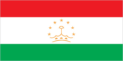
Flag description
three horizontal stripes of red (top), a wider stripe of white, and green; a gold crown surmounted by seven gold, five-pointed stars is located in the center of the white stripe Economy Tajikistan
GDP
purchasing power parity - $8.476 billion (2002 est.)
GDP - composition by sector
- agriculture
- 19%
- industry
- 26%
- services
- 55% (2002 est.)
GDP - per capita
purchasing power parity - $1,300 (2002 est.)
GDP - real growth rate
9.1% (2002 est.)
Geographic coordinates
39 00 N, 71 00 E
Geography - note
landlocked; mountainous region dominated by the Trans-Alay Range in the north and the Pamirs in the southeast; highest point, Qullai Ismoili Somoni (formerly Communism Peak), was the tallest mountain in the former USSR People Tajikistan
Government type
republic
Highways
- paved
- NA
- total
- 27,767 km
- unpaved
- NA (2000)
HIV/AIDS - adult prevalence rate
less than 0.1% (2001 est.)
HIV/AIDS - deaths
less than 100 (2001 est.)
HIV/AIDS - people living with HIV/AIDS
less than 200 (2001 est.)
Household income or consumption by percentage share
- highest 10%
- 25.2% (1998)
- lowest 10%
- 3.2%
Illicit drugs
major transit country for Afghan narcotics bound for Russian and, to a lesser extent, Western European markets; limited illicit cultivation of opium poppy for domestic consumption; Tajikistan seizes roughly 80 percent of all drugs captured in Central Asia and stands third world-wide in seizures of opiates (heroin and raw opium) This page was last updated on 18 December, 2003
Imports
$830 million f.o.b. (2002 est.)
Imports - commodities
electricity, petroleum products, aluminum oxide, machinery and equipment, foodstuffs
Imports - partners
Russia 22.7%, Uzbekistan 18.4%, Ukraine 11.2%, Kazakhstan 10%, Turkmenistan 6.5%, Azerbaijan 5.7%, India 4.4% (2002)
Independence
9 September 1991 (from Soviet Union)
Industrial production growth rate
10.3% (2000 est.)
Industries
aluminum, zinc, lead, chemicals and fertilizers, cement, vegetable oil, metal-cutting machine tools, refrigerators and freezers
Infant mortality rate
- female
- 99.63 deaths/1,000 live births (2003 est.)
- male
- 126.58 deaths/1,000 live births
- total
- 113.43 deaths/1,000 live births
Inflation rate (consumer prices)
12% (2001 est.)
International organization participation
AsDB, CIS, EAPC, EBRD, ECE, ECO, ESCAP, FAO, IAEA, IBRD, ICAO, ICCt, ICRM, IDA, IDB, IFAD, IFC, IFRCS, ILO, IMF, IOC, IOM, ITU, OIC, OPCW, OSCE, PFP, SCO, UN, UNCTAD, UNESCO, UNIDO, UPU, WCO, WFTU, WHO, WIPO, WMO, WTrO (observer)
Internet country code
.tj
Internet Service Providers (ISPs)
4 (2002)
Internet users
5,000 (2002) Transportation Tajikistan
Irrigated land
7,200 sq km (1998 est.)
Judicial branch
Supreme Court (judges are appointed by the president)
Labor force
3.187 million (2000)
Labor force - by occupation
agriculture 67.2%, industry 7.5%, services 25.3% (2000 est.)
Land boundaries
- border countries
- Afghanistan 1,206 km, China 414 km, Kyrgyzstan 870 km, Uzbekistan 1,161 km
- total
- 3,651 km
Land use
- arable land
- 5.41%
- other
- 93.67% (1998 est.)
- permanent crops
- 0.92%
Languages
Tajik (official), Russian widely used in government and business
Legal system
based on civil law system; no judicial review of legislative acts
Legislative branch
- bicameral Supreme Assembly or Majlisi Oli consists of the Assembly of Representatives (lower chamber) or Majlisi Namoyandagon (63 seats; members are elected by popular vote to serve five-year terms) and the National Assembly (upper chamber) or Majlisi Milliy (33 seats; members are indirectly elected, 25 selected by local deputies, 8 appointed by the president; all serve five-year terms)
- election results
- Assembly of Representatives - percent of vote by party - PDPT 65%, Communist Party 20%, Islamic Rebirth Party 7.5%, other 7.5%; seats by party - NA; National Assembly - percent of vote by party - NA%; seats by party - NA
- elections
- last held 27 February and 12 March 2000 for the Assembly of Representatives (next to be held NA 2005) and 23 March 2000 for the National Assembly (next to be held NA 2005)
Life expectancy at birth
- female
- 67.5 years (2003 est.)
- male
- 61.39 years
- total population
- 64.37 years
Literacy
- definition
- age 15 and over can read and write
- female
- 99.1% (2003 est.) Government Tajikistan
- male
- 99.6%
- total population
- 99.4%
Location
Central Asia, west of China
Map references
Asia
Maritime claims
none (landlocked)
Median age
- female
- 19.6 years (2002)
- male
- 19 years
- total
- 19.3 years
Military branches
Army, Air Force and Air Defense Force, Presidential National Guard, Security Forces (internal and border troops)
Military expenditures - dollar figure
$35.4 million (FY01)
Military expenditures - percent of GDP
3.9% (FY01) Transnational Issues Tajikistan
Military manpower - availability
- males age 15-49
- 1,704,457 (2003 est.)
Military manpower - fit for military service
- males age 15-49
- 1,397,188 (2003 est.)
Military manpower - military age
18 years of age (2003 est.)
Military manpower - reaching military age annually
- males
- 82,490 (2003 est.)
National holiday
Independence Day (or National Day), 9 September (1991)
Nationality
- adjective
- Tajikistani
- noun
- Tajikistani(s)
Natural gas - consumption
1.3 billion cu m (2001 est.)
Natural gas - exports
0 cu m (2001 est.)
Natural gas - imports
1.25 billion cu m (2001 est.)
Natural gas - production
50 million cu m (2001 est.)
Natural hazards
earthquakes and floods
Natural resources
hydropower, some petroleum, uranium, mercury, brown coal, lead, zinc, antimony, tungsten, silver, gold
Net migration rate
-3.06 migrant(s)/1,000 population (2003 est.)
Oil - consumption
20,000 bbl/day (2001 est.)
Oil - exports
NA (2001)
Oil - imports
NA (2001)
Oil - production
250 bbl/day (2001 est.)
Pipelines
gas 540 km; oil 38 km (2003)
Political parties and leaders
Democratic Party or DPT [Mahmadruzi ISKANDAROV, chairman]; Islamic Revival Party [Said Abdullo NURI, chairman]; People's Democratic Party of Tajikistan or PDPT [Emomali RAHMONOV]; Social Democratic Party or SDPT [Rahmatullo ZOIROV]; Socialist Party or SPT [Sherali KENJAYEV]; Tajik Communist Party or CPT [Shodi SHABDOLOV]
Political pressure groups and leaders
- there are two unregistered political parties with 1,000 or more
- members
- Progressive Party [Suton QUVVATOV]; Unity Party [Hikmatuko SAIDOV]
Population
6,863,752 (July 2003 est.)
Population below poverty line
60% (2001 est.)
Population growth rate
2.13% (2003 est.)
Ports and harbors
none
Radio broadcast stations
AM 8, FM 10, shortwave 2 (2002)
Radios
1.291 million (1991)
Railways
- broad gauge
- 482 km 1.520-m gauge (2002)
- total
- 482 km
Religions
Sunni Muslim 85%, Shi'a Muslim 5%
Sex ratio
- at birth
- 1.05 male(s)/female
- total population
- 0.99 male(s)/female (2003 est.)
- under 15 years
- 1.02 male(s)/female 15-64 years: 0.99 male(s)/female 65 years and over: 0.78 male(s)/female
Suffrage
18 years of age; universal
Telephone system
- domestic
- cable and microwave radio relay
- general assessment
- poorly developed and not well maintained; many towns are not reached by the national network
- international
- linked by cable and microwave radio relay to other CIS republics and by leased connections to the Moscow international gateway switch; Dushanbe linked by Intelsat to international gateway switch in Ankara (Turkey); satellite earth stations - 1 Orbita and 2 Intelsat
Telephones - main lines in use
363,000 (1997)
Telephones - mobile cellular
2,500 (1997)
Television broadcast stations
13 (2001)
Televisions
820,000 (1997)
Terrain
Pamir and Alay Mountains dominate landscape; western Fergana Valley in north, Kofarnihon and Vakhsh Valleys in southwest
Total fertility rate
4.17 children born/woman (2003 est.)
Unemployment rate
40% (2002 est.)
Waterways
none