2017 Edition
CIA World Factbook 2017 Archive (HTML)
Introduction
Background
Following World War I, France acquired a mandate over the northern portion of the former Ottoman Empire province of Syria. The French administered the area as Syria until granting it independence in 1946. The new country lacked political stability and experienced a series of military coups. Syria united with Egypt in February 1958 to form the United Arab Republic. In September 1961, the two entities separated, and the Syrian Arab Republic was reestablished. In the 1967 Arab-Israeli War, Syria lost the Golan Heights region to Israel. During the 1990s, Syria and Israel held occasional, albeit unsuccessful, peace talks over its return. In November 1970, Hafiz al-ASAD, a member of the socialist Ba'th Party and the minority Alawi sect, seized power in a bloodless coup and brought political stability to the country. Following the death of President Hafiz al-ASAD, his son, Bashar al-ASAD, was approved as president by popular referendum in July 2000. Syrian troops - stationed in Lebanon since 1976 in an ostensible peacekeeping role - were withdrawn in April 2005. During the July-August 2006 conflict between Israel and Hizballah, Syria placed its military forces on alert but did not intervene directly on behalf of its ally Hizballah. In May 2007, Bashar al-ASAD's second term as president was approved by popular referendum. Influenced by major uprisings that began elsewhere in the region, and compounded by additional social and economic factors, antigovernment protests broke out first in the southern province of Dar'a in March 2011 with protesters calling for the repeal of the restrictive Emergency Law allowing arrests without charge, the legalization of political parties, and the removal of corrupt local officials. Demonstrations and violent unrest spread across Syria with the size and intensity of protests fluctuating. The government responded to unrest with a mix of concessions - including the repeal of the Emergency Law, new laws permitting new political parties, and liberalizing local and national elections - and with military force and detentions. The government's ongoing violence to quell unrest and widespread armed opposition activity has led to extended clashes between government forces, their allies, and oppositionists. International pressure on the ASAD regime has intensified since late 2011, as the Arab League, the EU, Turkey, and the US expanded economic sanctions against the regime and those entities that support it. In December 2012, the Syrian National Coalition, was recognized by more than 130 countries as the sole legitimate representative of the Syrian people. Political negotiations between the government and opposition delegations at the UN-sponsored Geneva II conference in 2014 and the UN-sponsored Geneva III talks in 2016 failed to produce a resolution of the conflict. Unrest continues in Syria, and according to an April 2016 UN estimate, the death toll among Syrian Government forces, opposition forces, and civilians was over 400,000. As of December 2016, approximately 13.5 million people were in need of humanitarian assistance in Syria, with 6.3 million people displaced internally, and an additional 4.8 million Syrian refugees, making the Syrian situation the largest humanitarian crisis worldwide.
Geography
Area
- 185,180 sq km 183,630 sq km 1,550 sq km includes 1,295 sq km of Israeli-occupied territory
- land
- 183,630 sq km
- note
- includes 1,295 sq km of Israeli-occupied territory
- total
- 185,180 sq km
- water
- 1,550 sq km
Area - comparative
slightly more than 1.5 times the size of Pennsylvania
Climate
mostly desert; hot, dry, sunny summers (June to August) and mild, rainy winters (December to February) along coast; cold weather with snow or sleet periodically in Damascus
Coastline
193 km
Elevation
- 514 m lowest point: unnamed location near Lake Tiberias -208 m highest point: Mount Hermon (Jabal a-Shayk) 2,814 m
- elevation extremes
- lowest point: unnamed location near Lake Tiberias -208 m
- highest point
- Mount Hermon (Jabal a-Shayk) 2,814 m
- mean elevation
- 514 m
Environment - current issues
deforestation; overgrazing; soil erosion; desertification; water pollution from raw sewage and petroleum refining wastes; inadequate potable water
Environment - international agreements
- Biodiversity, Climate Change, Climate Change-Kyoto Protocol, Desertification, Endangered Species, Hazardous Wastes, Ozone Layer Protection, Ship Pollution, Wetlands Environmental Modification
- party to
- Biodiversity, Climate Change, Climate Change-Kyoto Protocol, Desertification, Endangered Species, Hazardous Wastes, Ozone Layer Protection, Ship Pollution, Wetlands
- signed, but not ratified
- Environmental Modification
Geographic coordinates
35 00 N, 38 00 E
Geography - note
the capital of Damascus - located at an oasis fed by the Barada River - is thought to be one of the world's oldest continuously inhabited cities; there are 42 Israeli settlements and civilian land use sites in the Israeli-occupied Golan Heights (2017)
Irrigated land
14,280 sq km (2012)
Land boundaries
- 2,363 km Iraq 599 km, Israel 83 km, Jordan 379 km, Lebanon 403 km, Turkey 899 km
- border countries (5)
- Iraq 599 km, Israel 83 km, Jordan 379 km, Lebanon 403 km, Turkey 899 km
- total
- 2,363 km
Land use
- 75.8% arable land 25.4%; permanent crops 5.8%; permanent pasture 44.6% 2.7% 21.5% (2011 est.)
- agricultural land
- 75.8%
- forest
- 2.7%
- other
- 21.5% (2011 est.)
Location
Middle East, bordering the Mediterranean Sea, between Lebanon and Turkey
Map references
Middle East
Maritime claims
- 12 nm 24 nm
- contiguous zone
- 24 nm
- territorial sea
- 12 nm
Natural hazards
- dust storms, sandstorms Syria's two historically active volcanoes, Es Safa and an unnamed volcano near the Turkish border have not erupted in centuries
- volcanism
- Syria's two historically active volcanoes, Es Safa and an unnamed volcano near the Turkish border have not erupted in centuries
Natural resources
petroleum, phosphates, chrome and manganese ores, asphalt, iron ore, rock salt, marble, gypsum, hydropower
Population - distribution
- significant population density along the Mediterranean coast; larger concentrations found in the major cities of Damascus, Aleppo (the country's largest city), and Hims (Homs); more than half of the population lives in the coastal plain, the province of Halab, and the Euphrates River valley the ongoing civil war has altered the population distribution
- note
- the ongoing civil war has altered the population distribution
Terrain
primarily semiarid and desert plateau; narrow coastal plain; mountains in west
People and Society
Age structure
- 31.62% (male 2,923,814/female 2,777,073) 19.54% (male 1,790,360/female 1,732,694) 39.22% (male 3,522,653/female 3,547,540) 5.41% (male 482,576/female 493,085) 4.21% (male 342,407/female 416,347) (2017 est.)
- 0-14 years
- 31.62% (male 2,923,814/female 2,777,073)
- 15-24 years
- 19.54% (male 1,790,360/female 1,732,694)
- 25-54 years
- 39.22% (male 3,522,653/female 3,547,540)
- 55-64 years
- 5.41% (male 482,576/female 493,085)
- 65 years and over
- 4.21% (male 342,407/female 416,347) (2017 est.)
Birth rate
21.2 births/1,000 population (2017 est.)
Children under the age of 5 years underweight
10.1% (2009)
Contraceptive prevalence rate
53.9% (2009/10)
Death rate
4 deaths/1,000 population (2017 est.)
Dependency ratios
- 72.8 65.8 14.3 (2015 est.)
- elderly dependency ratio
- 7
- potential support ratio
- 14.3 (2015 est.)
- total dependency ratio
- 72.8
- youth dependency ratio
- 65.8
Drinking water source
- urban: 92.3% of population rural: 87.2% of population total: 90.1% of population urban: 7.7% of population rural: 12.8% of population total: 9.9% of population (2015 est.)
- rural
- 12.8% of population
- total
- 9.9% of population (2015 est.)
- urban
- 7.7% of population
Education expenditures
5.1% of GDP (2009)
Ethnic groups
Arab 90.3%, Kurdish, Armenian, and other 9.7%
Health expenditures
3.3% of GDP (2014)
HIV/AIDS - adult prevalence rate
NA
HIV/AIDS - deaths
NA (2016 est.)
HIV/AIDS - people living with HIV/AIDS
NA
Hospital bed density
1.5 beds/1,000 population (2012)
Infant mortality rate
- 14.8 deaths/1,000 live births 17 deaths/1,000 live births 12.5 deaths/1,000 live births (2017 est.)
- female
- 12.5 deaths/1,000 live births (2017 est.)
- male
- 17 deaths/1,000 live births
- total
- 14.8 deaths/1,000 live births
Languages
Arabic (official), Kurdish, Armenian, Aramaic, Circassian, French, English
Life expectancy at birth
- 75.1 years 72.7 years 77.6 years (2017 est.)
- female
- 77.6 years (2017 est.)
- male
- 72.7 years
- total population
- 75.1 years
Literacy
- age 15 and over can read and write 86.4% 91.7% 81% (2015 est.)
- definition
- age 15 and over can read and write
- female
- 81% (2015 est.)
- male
- 91.7%
- total population
- 86.4%
Major urban areas - population
Aleppo 3.562 million; DAMASCUS (capital) 2.566 million; Hims (Homs) 1.641 million; Hamah 1.237 million; Lattakia 781,000 (2015)
Maternal mortality rate
68 deaths/100,000 live births (2015 est.)
Median age
- 24.3 years 23.9 years 24.8 years (2017 est.)
- female
- 24.8 years (2017 est.)
- male
- 23.9 years
- total
- 24.3 years
Nationality
- Syrian(s) Syrian
- adjective
- Syrian
- noun
- Syrian(s)
Net migration rate
NA (2017 est.)
Obesity - adult prevalence rate
27.8% (2016)
Physicians density
1.55 physicians/1,000 population (2014)
Population
- 18,028,549 (July 2017 est.) approximately 20,500 Israeli settlers live in the Golan Heights (2014)
- note
- approximately 20,500 Israeli settlers live in the Golan Heights (2014)
Population distribution
- significant population density along the Mediterranean coast; larger concentrations found in the major cities of Damascus, Aleppo (the country's largest city), and Hims (Homs); more than half of the population lives in the coastal plain, the province of Halab, and the Euphrates River valley the ongoing civil war has altered the population distribution
- note
- the ongoing civil war has altered the population distribution
Population growth rate
7.87% (2017 est.)
Religions
Muslim 87% (official; includes Sunni 74% and Alawi, Ismaili, and Shia 13%), Christian 10% (includes Orthodox, Uniate, and Nestorian), Druze 3%, Jewish (few remaining in Damascus and Aleppo)
Sanitation facility access
- urban: 96.2% of population rural: 95.1% of population total: 95.7% of population urban: 3.8% of population rural: 4.9% of population total: 4.3% of population (2015 est.)
- rural
- 4.9% of population
- total
- 4.3% of population (2015 est.)
- urban
- 3.8% of population
School life expectancy (primary to tertiary education)
- 9 years 9 years 9 years (2013)
- female
- 9 years (2013)
- male
- 9 years
- total
- 9 years
Sex ratio
- 1.06 male(s)/female 1.05 male(s)/female 1.03 male(s)/female 0.99 male(s)/female 0.98 male(s)/female 0.82 male(s)/female 1.01 male(s)/female (2016 est.)
- 0-14 years
- 1.05 male(s)/female
- 15-24 years
- 1.03 male(s)/female
- 25-54 years
- 0.99 male(s)/female
- 55-64 years
- 0.98 male(s)/female
- 65 years and over
- 0.82 male(s)/female
- at birth
- 1.06 male(s)/female
- total population
- 1.01 male(s)/female (2016 est.)
Total fertility rate
2.5 children born/woman (2017 est.)
Unemployment, youth ages 15-24
- 35.8% 26.6% 71.1% (2011 est.)
- female
- 71.1% (2011 est.)
- male
- 26.6%
- total
- 35.8%
Urbanization
- 58.5% of total population (2017) 3.59% annual rate of change (2015-20 est.)
- rate of urbanization
- 3.59% annual rate of change (2015-20 est.)
- urban population
- 58.5% of total population (2017)
Government
Administrative divisions
14 provinces (muhafazat, singular - muhafazah); Al Hasakah, Al Ladhiqiyah (Latakia), Al Qunaytirah, Ar Raqqah, As Suwayda', Dar'a, Dayr az Zawr, Dimashq (Damascus), Halab, Hamah, Hims (Homs), Idlib, Rif Dimashq (Damascus Countryside), Tartus
Capital
- Damascus 33 30 N, 36 18 E UTC+2 (7 hours ahead of Washington, DC, during Standard Time) +1hr, begins midnight on the last Friday in March; ends at midnight on the last Friday in October
- daylight saving time
- +1hr, begins midnight on the last Friday in March; ends at midnight on the last Friday in October
- geographic coordinates
- 33 30 N, 36 18 E
- name
- Damascus
- time difference
- UTC+2 (7 hours ahead of Washington, DC, during Standard Time)
Citizenship
- no the father must be a citizen of Syria; if the father is unknown or stateless, the mother must be a citizen of Syria yes 10 years
- citizenship by birth
- no
- citizenship by descent only
- the father must be a citizen of Syria; if the father is unknown or stateless, the mother must be a citizen of Syria
- dual citizenship recognized
- yes
- residency requirement for naturalization
- 10 years
Constitution
- several previous; latest issued 15 February 2012, passed by referendum and effective 27 February 2012 proposed by the president of the republic or by one-third of the People’s Assembly members; following review by a special Assembly committee, passage requires at least three-quarters majority vote by the Assembly and approval by the president (2016)
- amendments
- proposed by the president of the republic or by one-third of the People’s Assembly members; following review by a special Assembly committee, passage requires at least three-quarters majority vote by the Assembly and approval by the president (2016)
- history
- several previous; latest issued 15 February 2012, passed by referendum and effective 27 February 2012
Country name
- Syrian Arab Republic Syria Al Jumhuriyah al Arabiyah as Suriyah Suriyah United Arab Republic (with Egypt) name ultimately derived from the ancient Assyrians who dominated northern Mesopotamia, but whose reach also extended westward to the Levant; over time, the name came to be associated more with the western area
- conventional long form
- Syrian Arab Republic
- conventional short form
- Syria
- etymology
- name ultimately derived from the ancient Assyrians who dominated northern Mesopotamia, but whose reach also extended westward to the Levant; over time, the name came to be associated more with the western area
- former
- United Arab Republic (with Egypt)
- local long form
- Al Jumhuriyah al Arabiyah as Suriyah
- local short form
- Suriyah
Diplomatic representation from the US
- ambassador (vacant); US Special Envoy for Syria Michael RATNEY (since 27 July 2015); note - on 6 February 2012, the US closed its embassy in Damascus; Czechia serves as protecting power for US interests in Syria Abou Roumaneh, 2 Al Mansour Street, Damascus P. O. Box 29, Damascus [963] (11) 3391-4444 [963] (11) 3391-3999
- chief of mission
- ambassador (vacant); US Special Envoy for Syria Michael RATNEY (since 27 July 2015); note - on 6 February 2012, the US closed its embassy in Damascus; Czechia serves as protecting power for US interests in Syria
- embassy
- Abou Roumaneh, 2 Al Mansour Street, Damascus
- FAX
- [963] (11) 3391-3999
- mailing address
- P. O. Box 29, Damascus
- telephone
- [963] (11) 3391-4444
Diplomatic representation in the US
- Embassy ceased operations and closed on 18 March 2014 Ambassador (vacant); Charge d'Affaires Mounir KOUDMANI (since 1 June 2012) 2215 Wyoming Avenue NW, Washington, DC 20008 [1] (202) 232-6313 [1] (202) 234-9548
- chancery
- 2215 Wyoming Avenue NW, Washington, DC 20008
- chief of mission
- Ambassador (vacant); Charge d'Affaires Mounir KOUDMANI (since 1 June 2012)
- FAX
- [1] (202) 234-9548
- note
- Embassy ceased operations and closed on 18 March 2014
- telephone
- [1] (202) 232-6313
Executive branch
- President Bashar al-ASAD (since 17 July 2000); Vice President Najah al-ATTAR (since 23 March 2006) Prime Minister Imad Muhammad Dib KHAMIS (since 22 June 2016); Deputy Prime Ministers Fahd Jasim al-FURAYJ, Lt. Gen.(since 23 June 2012) and Walid al-MUALEM (since 23 June 2012) Council of Ministers appointed by the president president directly elected by simple majority popular vote for a 7-year term (eligible for a second term); election last held on 3 June 2014 (next to be held in June 2021); the president appoints the vice presidents, prime minister, and deputy prime ministers Bashar al-ASAD elected president; percent of vote - Bashar al-ASAD (Ba'th Party) 88.7%, Hassan al-NOURI (independent) 4.3%, Maher HAJJER (independent) 3.2%, other/invalid 3.8%
- cabinet
- Council of Ministers appointed by the president
- chief of state
- President Bashar al-ASAD (since 17 July 2000); Vice President Najah al-ATTAR (since 23 March 2006)
- election results
- Bashar al-ASAD elected president; percent of vote - Bashar al-ASAD (Ba'th Party) 88.7%, Hassan al-NOURI (independent) 4.3%, Maher HAJJER (independent) 3.2%, other/invalid 3.8%
- elections/appointments
- president directly elected by simple majority popular vote for a 7-year term (eligible for a second term); election last held on 3 June 2014 (next to be held in June 2021); the president appoints the vice presidents, prime minister, and deputy prime ministers
- head of government
- Prime Minister Imad Muhammad Dib KHAMIS (since 22 June 2016); Deputy Prime Ministers Fahd Jasim al-FURAYJ, Lt. Gen.(since 23 June 2012) and Walid al-MUALEM (since 23 June 2012)
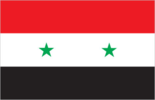
Flag description
- three equal horizontal bands of red (top), white, and black; two small, green, five-pointed stars in a horizontal line centered in the white band; the band colors derive from the Arab Liberation flag and represent oppression (black), overcome through bloody struggle (red), to be replaced by a bright future (white); identical to the former flag of the United Arab Republic (1958-1961) where the two stars represented the constituent states of Syria and Egypt; the current design dates to 1980 similar to the flag of Yemen, which has a plain white band, Iraq, which has an Arabic inscription centered in the white band, and that of Egypt, which has a gold Eagle of Saladin centered in the white band
- note
- similar to the flag of Yemen, which has a plain white band, Iraq, which has an Arabic inscription centered in the white band, and that of Egypt, which has a gold Eagle of Saladin centered in the white band
Government type
presidential republic; highly authoritarian regime
Independence
17 April 1946 (from League of Nations mandate under French administration)
International law organization participation
has not submitted an ICJ jurisdiction declaration; non-party state to the ICCt
International organization participation
ABEDA, AFESD, AMF, CAEU, FAO, G-24, G-77, IAEA, IBRD, ICAO, ICC (national committees), ICRM, IDA, IDB, IFAD, IFC, IFRCS, IHO, ILO, IMF, IMO, Interpol, IOC, IPU, ISO, ITSO, ITU, LAS, MIGA, NAM, OAPEC, OIC, OPCW, UN, UNCTAD, UNESCO, UNIDO, UNRWA, UNWTO, UPU, WCO, WFTU (NGOs), WHO, WIPO, WMO, WTO (observer)
Judicial branch
- Court of Cassation (organized into civil, criminal, religious, and military divisions, each with 3 judges); Supreme Constitutional Court (consists of 7 members) Court of Cassation judges appointed by the Supreme Judicial Council or SJC, a judicial management body headed by the minister of justice with 7 members including the national president; judge tenure NA; Supreme Constitutional Court judges nominated by the president and appointed by the SJC; judges appointed for 4-year renewable terms courts of first instance; magistrates' courts; religious and military courts; Economic Security Court; Counterterrorism Court (established June 2012)
- highest court(s)
- Court of Cassation (organized into civil, criminal, religious, and military divisions, each with 3 judges); Supreme Constitutional Court (consists of 7 members)
- judge selection and term of office
- Court of Cassation judges appointed by the Supreme Judicial Council or SJC, a judicial management body headed by the minister of justice with 7 members including the national president; judge tenure NA; Supreme Constitutional Court judges nominated by the president and appointed by the SJC; judges appointed for 4-year renewable terms
- subordinate courts
- courts of first instance; magistrates' courts; religious and military courts; Economic Security Court; Counterterrorism Court (established June 2012)
Legal system
mixed legal system of civil and Islamic law (for family courts)
Legislative branch
- unicameral People's Assembly or Majlis al-Shaab (250 seats; members directly elected in multi-seat constituencies by proportional representation vote to serve 4-year terms) last held on 13 April 2016 (next to be held in 2020) percent of vote by party - NPF 80%, other 20%; seats by party - NPF 200, other 50
- description
- unicameral People's Assembly or Majlis al-Shaab (250 seats; members directly elected in multi-seat constituencies by proportional representation vote to serve 4-year terms)
- election results
- percent of vote by party - NPF 80%, other 20%; seats by party - NPF 200, other 50
- elections
- last held on 13 April 2016 (next to be held in 2020)
National anthem
- "Humat ad-Diyar" (Guardians of the Homeland) Khalil Mardam BEY/Mohammad Salim FLAYFEL and Ahmad Salim FLAYFEL adopted 1936, restored 1961; between 1958 and 1961, while Syria was a member of the United Arab Republic with Egypt, the country had a different anthem
- lyrics/music
- Khalil Mardam BEY/Mohammad Salim FLAYFEL and Ahmad Salim FLAYFEL
- name
- "Humat ad-Diyar" (Guardians of the Homeland)
- note
- adopted 1936, restored 1961; between 1958 and 1961, while Syria was a member of the United Arab Republic with Egypt, the country had a different anthem
National holiday
Independence Day (Evacuation Day), 17 April (1946); note - celebrates the leaving of the last French troops and the proclamation of full independence
National symbol(s)
- hawk; national colors: red, white, black, green
- hawk; national colors
- red, white, black, green
Political parties and leaders
- Arab Socialist Ba'ath Party [Bashar al-ASAD, regional secretary] Arab Socialist Union of Syria or ASU [Safwan al-QUDSI] National Progressive Front or NPF [Bashar al-ASAD, Suleiman QADDAH] (alliance includes Arab Socialist Renaissance (Ba'th) Party [President Bashar al-ASAD], Socialist Unionist Democratic Party [Fadlallah Nasr al-DIN]) Syrian Communist Party (two branches) [Wissal Farha BAKDASH, Yusuf Rashid FAYSAL] Syrian Social Nationalist Party or SSNP [Ali HAIDAR] Unionist Socialist Party [Fayez ISMAIL] Kurdish Azadi Party Kurdish Democratic Accord Party (al Wifaq) [Fowzi SHINKALI] Kurdish Democratic Left Party [Saleh KIDDO] Kurdish Democratic Party (al Parti-Ibrahim wing) [Nasr al-Din IBRAHIM] Kurdish Democratic Party (al Parti-Mustafa wing) Kurdish Democratic Party in Syria or KDP-S [Saud AL-MALA] Kurdish Democratic Patriotic/National Party Kurdish Democratic Peace Party [Talal MOHAMMED] Kurdish Democratic Progressive Party or KDPP-Darwish Kurdish Democratic Progressive Party or KDPP-Muhammad Kurdish Democratic Union Party or PYD [Salih Muslim MOHAMMAD] Kurdish Democratic Unity Party [Kamiron Haj ABDU] Kurdish Democratic Yekiti Party [Mahi al-Din Sheikh ALI] Kurdish Equality Party [Namet DAOUD] Kurdish Future Party [Rezan HASSAN] Kurdish Green Party [ Laqman AHMI] Kurdish Left Party [Shallal KIDDO] Kurdish National Democratic Rally in Syria Kurdish Reform Movement in Syria [Amjad OTHMAN] Kurdish Reform Movement Party [ Feisal AL-YUSSEF] Kurdish Yekiti (Union) Party Kurdistan Communist Party [ Nejm al-Sin MALA’AMIR] Kurdistan Democratic Party in Syria [Abdul Karim SAKKO] Kurdistan Liberal Union [Farhad TILO] Syrian Kurdish Democratic Party Tiyar al-Mustaqbal [Narin MATINI] Syrian Democratic Party [Mustafa QALAAJI]
- Kurdish parties (considered illegal)
- Kurdish Azadi Party
- legal parties/alliances
- Arab Socialist Ba'ath Party [Bashar al-ASAD, regional secretary]
- other
- Syrian Democratic Party [Mustafa QALAAJI]
Political pressure groups and leaders
- Free Syrian Army Syrian Muslim Brotherhood or SMB [Mohamed Hekmat WALID] (operates in exile in London) Syrian Opposition Coalition or National Coalition of Syrian Revolutionary and Opposition Forces [Riad SEIF] there are also hundreds of local and provincial political and armed opposition groups that organize protests, provide civilian services, and stage armed attacks
- note
- there are also hundreds of local and provincial political and armed opposition groups that organize protests, provide civilian services, and stage armed attacks
Suffrage
18 years of age; universal
Economy
Agriculture - products
wheat, barley, cotton, lentils, chickpeas, olives, sugar beets; beef, mutton, eggs, poultry, milk
Budget
- $496.6 million $2.889 billion government projections for FY2016 (2016 est.)
- expenditures
- $2.889 billion
- note
- government projections for FY2016 (2016 est.)
- revenues
- $496.6 million
Budget surplus (+) or deficit (-)
-9.7% of GDP (2016 est.)
Central bank discount rate
0.75% (31 December 2016) 5% (31 December 2015)
Commercial bank prime lending rate
32% (31 December 2016 est.) 27% (31 December 2015 est.)
Current account balance
$-2.077 billion (2016 est.) $-2.955 billion (2015 est.)
Debt - external
$5.085 billion (31 December 2016 est.) $4.42 billion (31 December 2015 est.)
Economy - overview
Syria's economy continues to deteriorate amid the ongoing conflict that began in 2011, declining by more than 70% from 2010 to 2016. The government has struggled to address the effects of international sanctions, widespread infrastructure damage, diminished domestic consumption and production, reduced subsidies, and high inflation, which have caused dwindling foreign exchange reserves, rising budget and trade deficits, a decreasing value of the Syrian pound, and falling household purchasing power. During 2014, the ongoing conflict and continued unrest and economic decline worsened the humanitarian crisis and elicited a greater need for international assistance, as the number of people in need inside Syria increased from 9.3 million to 12.2 million, and the number of Syrian refugees increased from 2.2 million to more than 3.3 million. Prior to the turmoil, Damascus had begun liberalizing economic policies, including cutting lending interest rates, opening private banks, consolidating multiple exchange rates, raising prices on some subsidized items, and establishing the Damascus Stock Exchange, but the economy remains highly regulated. Long-run economic constraints include foreign trade barriers, declining oil production, high unemployment, rising budget deficits, increasing pressure on water supplies caused by heavy use in agriculture, rapid population growth, industrial expansion, water pollution, and widespread infrastructure damage.
Exchange rates
Syrian pounds (SYP) per US dollar - 459.2 (2016 est.) 459.2 (2015 est.) 236.41 (2014 est.) 153.695 (2013 est.) 64.39 (2012 est.)
Exports
$1.705 billion (2016 est.) $1.587 billion (2015 est.)
Exports - commodities
crude oil, minerals, petroleum products, fruits and vegetables, cotton fiber, textiles, clothing, meat and live animals, wheat
Exports - partners
Lebanon 34.6%, Jordan 11.6%, China 9.4%, Turkey 8.2%, Iraq 7.7%, Tunisia 4.9% (2016)
Fiscal year
calendar year
GDP - composition, by end use
- 65.6% 23.5% 17.6% 11.4% 10.8% -29% (2016 est.)
- exports of goods and services
- 10.8%
- government consumption
- 23.5%
- household consumption
- 65.6%
- imports of goods and services
- -29% (2016 est.)
- investment in fixed capital
- 17.6%
- investment in inventories
- 11.4%
GDP - composition, by sector of origin
- 19.5% 19% 61.5% (2016 est.)
- agriculture
- 19.5%
- industry
- 19%
- services
- 61.5% (2016 est.)
GDP - per capita (PPP)
- $2,900 (2015 est.) $3,300 (2014 est.) $2,800 (2013 est.) data are in 2015 US dollars
- note
- data are in 2015 US dollars
GDP - real growth rate
- NA% (2016 est.) -9.9% (2014 est.) -36.5% (2013 est.) data are in 2015 dollars
- note
- data are in 2015 dollars
GDP (official exchange rate)
$24.6 billion (2014 est.)
GDP (purchasing power parity)
- $NA (2015 est.) $55.8 billion (2014 est.) $61.9 billion (2013 est.) data are in 2015 US dollars the war-driven deterioration of the economy resulted in a disappearance of quality national level statistics in the 2012-13 period
- notes
- data are in 2015 US dollars
Gross national saving
19.1% of GDP (2016 est.) 20.1% of GDP (2015 est.) 18.2% of GDP (2014 est.)
Household income or consumption by percentage share
- NA% NA%
- highest 10%
- NA%
- lowest 10%
- NA%
Imports
$5.496 billion (2016 est.) $6.076 billion (2015 est.)
Imports - commodities
machinery and transport equipment, electric power machinery, food and livestock, metal and metal products, chemicals and chemical products, plastics, yarn, paper
Imports - partners
Russia 22%, Turkey 20%, China 11.3% (2016)
Industrial production growth rate
-2.4% (2016 est.)
Industries
petroleum, textiles, food processing, beverages, tobacco, phosphate rock mining, cement, oil seeds crushing, automobile assembly
Inflation rate (consumer prices)
43.9% (2016 est.) 38.1% (2015 est.)
Labor force
3.871 million (2016 est.)
Labor force - by occupation
- 17% 16% 67% (2008 est.)
- agriculture
- 17%
- industry
- 16%
- services
- 67% (2008 est.)
Market value of publicly traded shares
$NA
Population below poverty line
82.5% (2014 est.)
Public debt
55.7% of GDP (2016 est.) 48.9% of GDP (2015 est.)
Reserves of foreign exchange and gold
$504.6 million (31 December 2016 est.) $772.9 million (31 December 2015 est.)
Stock of broad money
$5.522 billion (31 December 2016 est.) $6.98 billion (31 December 2015 est.)
Stock of domestic credit
$5.993 billion (31 December 2016 est.) $7.225 billion (31 December 2015 est.)
Stock of narrow money
$4.488 billion (31 December 2016 est.) $5.254 billion (31 December 2015 est.)
Taxes and other revenues
2% of GDP (2016 est.)
Unemployment rate
50% (2016 est.) 50% (2015 est.)
Energy
Carbon dioxide emissions from consumption of energy
49 million Mt (2013 est.)
Crude oil - exports
0 bbl/day (2014 est.)
Crude oil - imports
83,140 bbl/day (2014 est.)
Crude oil - production
28,670 bbl/day (2016 est.)
Crude oil - proved reserves
2.5 billion bbl (1 January 2017 es)
Electricity - consumption
13.96 billion kWh (2015 est.)
Electricity - exports
262 million kWh (2015 est.)
Electricity - from fossil fuels
84.4% of total installed capacity (2015 est.)
Electricity - from hydroelectric plants
15.6% of total installed capacity (2015 est.)
Electricity - from nuclear fuels
0% of total installed capacity (2015 est.)
Electricity - from other renewable sources
0% of total installed capacity (2015 est.)
Electricity - imports
0 kWh (2016 est.)
Electricity - installed generating capacity
9.61 million kW (2015 est.)
Electricity - production
16.83 billion kWh (2015 est.)
Electricity access
- 1,600,000 96% 100% 81% (2013)
- electrification - rural areas
- 81% (2013)
- electrification - total population
- 96%
- electrification - urban areas
- 100%
- population without electricity
- 1,600,000
Natural gas - consumption
4.9 billion cu m (2015 est.)
Natural gas - exports
0 cu m (2013 est.)
Natural gas - imports
249.2 million cu m (2011 est.)
Natural gas - production
4.3 billion cu m (2015 est.)
Natural gas - proved reserves
240.7 billion cu m (1 January 2017 es)
Refined petroleum products - consumption
140,000 bbl/day (2015 est.)
Refined petroleum products - exports
12,500 bbl/day (2014 est.)
Refined petroleum products - imports
41,120 bbl/day (2014 est.)
Refined petroleum products - production
111,600 bbl/day (2014 est.)
Communications
Broadcast media
state-run TV and radio broadcast networks; state operates 2 TV networks and a satellite channel; roughly two-thirds of Syrian homes have a satellite dish providing access to foreign TV broadcasts; 3 state-run radio channels; first private radio station launched in 2005; private radio broadcasters prohibited from transmitting news or political content (2007)
Internet country code
.sy
Internet users
- 5,476,850 31.9% (July 2016 est.)
- percent of population
- 31.9% (July 2016 est.)
- total
- 5,476,850
Telephone system
- the armed insurgency that began in 2011 has led to major disruptions to the network and has caused telephone and Internet outages throughout the country the number of fixed-line connections increased markedly prior to the civil war in 2011; mobile-cellular service stands at about 70 per 100 persons country code - 963; submarine cable connection to Egypt, Lebanon, and Cyprus; satellite earth stations - 1 Intelsat (Indian Ocean) and 1 Intersputnik (Atlantic Ocean region); coaxial cable and microwave radio relay to Iraq, Jordan, Lebanon, and Turkey; participant in Medarabtel (2016)
- domestic
- the number of fixed-line connections increased markedly prior to the civil war in 2011; mobile-cellular service stands at about 70 per 100 persons
- general assessment
- the armed insurgency that began in 2011 has led to major disruptions to the network and has caused telephone and Internet outages throughout the country
- international
- country code - 963; submarine cable connection to Egypt, Lebanon, and Cyprus; satellite earth stations - 1 Intelsat (Indian Ocean) and 1 Intersputnik (Atlantic Ocean region); coaxial cable and microwave radio relay to Iraq, Jordan, Lebanon, and Turkey; participant in Medarabtel (2016)
Telephones - fixed lines
- 3,464,846 20 (July 2016 est.)
- subscriptions per 100 inhabitants
- 20 (July 2016 est.)
- total subscriptions
- 3,464,846
Telephones - mobile cellular
- 12,350,927 72 (July 2016 est.)
- subscriptions per 100 inhabitants
- 72 (July 2016 est.)
- total
- 12,350,927
Transportation
Airports
90 (2013)
Airports - with paved runways
- 5 (2013)
- 2,438 to 3,047 m
- 16
- 914 to 1,523 m
- 3
- over 3,047 m
- 5
- total
- 29
- under 914 m
- 5 (2013)
Airports - with unpaved runways
- 48 (2013)
- 1,524 to 2,437 m
- 1
- 914 to 1,523 m
- 12
- total
- 61
- under 914 m
- 48 (2013)
Civil aircraft registration country code prefix
YK (2016)
Heliports
6 (2013)
Merchant marine
- bulk carrier 4, cargo 14, carrier 1 166 (Barbados 1, Belize 4, Bolivia 4, Cambodia 22, Comoros 5, Dominica 4, Georgia 24, Lebanon 2, Liberia 1, Malta 4, Moldova 5, North Korea 4, Panama 34, Saint Vincent and the Grenadines 9, Sierra Leone 13, Tanzania 23, Togo 6, unknown 1) (2010)
- by type
- bulk carrier 4, cargo 14, carrier 1
- registered in other countries
- 166 (Barbados 1, Belize 4, Bolivia 4, Cambodia 22, Comoros 5, Dominica 4, Georgia 24, Lebanon 2, Liberia 1, Malta 4, Moldova 5, North Korea 4, Panama 34, Saint Vincent and the Grenadines 9, Sierra Leone 13, Tanzania 23, Togo 6, unknown 1) (2010)
- total
- 19
National air transport system
- 475,932 1,517,388 mt-km (2015)
- annual freight traffic on registered air carriers
- 1,517,388 mt-km (2015)
- annual passenger traffic on registered air carriers
- 475,932
- inventory of registered aircraft operated by air carriers
- 11
- number of registered air carriers
- 2
Pipelines
gas 3,170 km; oil 2,029 km (2013)
Ports and terminals
- Baniyas, Latakia, Tartus
- major seaport(s)
- Baniyas, Latakia, Tartus
Railways
- 2,052 km 1,801 km 1.435-m gauge 251 km 1.050-m gauge (2014)
- narrow gauge
- 251 km 1.050-m gauge (2014)
- standard gauge
- 1,801 km 1.435-m gauge
- total
- 2,052 km
Roadways
- 69,873 km 63,060 km 6,813 km (2010)
- paved
- 63,060 km
- total
- 69,873 km
- unpaved
- 6,813 km (2010)
Waterways
900 km (navigable but not economically significant) (2011)
Military and Security
Military branches
- Syrian Armed Forces: Land Forces, Naval Forces, Air Forces (includes Air Defense Forces), Intelligence Services (Air Force Intelligence, Military Intelligence) Ministry of Interior: Political Security Directorate, General Intelligence Directorate, National Police Force (2017)
- Ministry of Interior
- Political Security Directorate, General Intelligence Directorate, National Police Force (2017)
- Syrian Armed Forces
- Land Forces, Naval Forces, Air Forces (includes Air Defense Forces), Intelligence Services (Air Force Intelligence, Military Intelligence)
Military service age and obligation
18 years of age for compulsory and voluntary military service; conscript service obligation is 18 months; women are not conscripted but may volunteer to serve (2017)
Transnational Issues
Disputes - international
Golan Heights is Israeli-occupied with the almost 1,000-strong UN Disengagement Observer Force patrolling a buffer zone since 1964; lacking a treaty or other documentation describing the boundary, portions of the Lebanon-Syria boundary are unclear with several sections in dispute; since 2000, Lebanon has claimed Shab'a Farms in the Golan Heights; 2004 Agreement and pending demarcation would settle border dispute with Jordan
Illicit drugs
a transit point for opiates, hashish, and cocaine bound for regional and Western markets; weak anti-money-laundering controls and bank privatization may leave it vulnerable to money laundering
Refugees and internally displaced persons
- 438,000 (Palestinian Refugees) (2017); 16,879 (Iraq) the ongoing civil war has more than 5.3 million Syrian refugees - dispersed in Egypt, Iraq, Jordan, Lebanon, and Turkey - as of November 2017 6.3 million (ongoing civil war since 2011) (2017) 160,000 (2016); note - Syria's stateless population consists of Kurds and Palestinians; stateless persons are prevented from voting, owning land, holding certain jobs, receiving food subsidies or public healthcare, enrolling in public schools, or being legally married to Syrian citizens; in 1962, some 120,000 Syrian Kurds were stripped of their Syrian citizenship, rendering them and their descendants stateless; in 2011, the Syrian Government granted citizenship to thousands of Syrian Kurds as a means of appeasement; however, resolving the question of statelessness is not a priority given Syria's ongoing civil war
- IDPs
- 6.3 million (ongoing civil war since 2011) (2017)
- note
- the ongoing civil war has more than 5.3 million Syrian refugees - dispersed in Egypt, Iraq, Jordan, Lebanon, and Turkey - as of November 2017
- refugees (country of origin)
- 438,000 (Palestinian Refugees) (2017); 16,879 (Iraq)
- stateless persons
- 160,000 (2016); note - Syria's stateless population consists of Kurds and Palestinians; stateless persons are prevented from voting, owning land, holding certain jobs, receiving food subsidies or public healthcare, enrolling in public schools, or being legally married to Syrian citizens; in 1962, some 120,000 Syrian Kurds were stripped of their Syrian citizenship, rendering them and their descendants stateless; in 2011, the Syrian Government granted citizenship to thousands of Syrian Kurds as a means of appeasement; however, resolving the question of statelessness is not a priority given Syria's ongoing civil war
Trafficking in persons
- as conditions continue to deteriorate due to Syria’s civil war, human trafficking has increased; Syrians remaining in the country and those that are refugees abroad are vulnerable to trafficking; Syria is a source and destination country for men, women and children subjected to forced labor and sex trafficking; Syrian children continue to be forcibly recruited by government forces, pro-regime militias, armed opposition groups, and terrorist organizations to serve as soldiers, human shields, and executioners; ISIL forces Syrian women and girls and Yazidi women and girls taken from Iraq to marry its fighters, where they experience domestic servitude and sexual violence; Syrian refugee women and girls are forced into exploitive marriages or prostitution in neighboring countries, while displaced children are forced into street begging domestically and abroad Tier 3 - the government does not fully comply with the minimum standards for the elimination of trafficking and is not making significant efforts to do so; in 2014, Syria’s violent conditions enabled human trafficking to flourish; the government made no effort to investigate, prosecute, or convict trafficking offenders or complicit government officials, including those who forcibly recruited child soldiers; authorities did not identify victims and failed to ensure victims, including child soldiers, were protected from arrest, detention, and severe abuse as a result of being trafficked (2015)
- current situation
- as conditions continue to deteriorate due to Syria’s civil war, human trafficking has increased; Syrians remaining in the country and those that are refugees abroad are vulnerable to trafficking; Syria is a source and destination country for men, women and children subjected to forced labor and sex trafficking; Syrian children continue to be forcibly recruited by government forces, pro-regime militias, armed opposition groups, and terrorist organizations to serve as soldiers, human shields, and executioners; ISIL forces Syrian women and girls and Yazidi women and girls taken from Iraq to marry its fighters, where they experience domestic servitude and sexual violence; Syrian refugee women and girls are forced into exploitive marriages or prostitution in neighboring countries, while displaced children are forced into street begging domestically and abroad
- tier rating
- Tier 3 - the government does not fully comply with the minimum standards for the elimination of trafficking and is not making significant efforts to do so; in 2014, Syria’s violent conditions enabled human trafficking to flourish; the government made no effort to investigate, prosecute, or convict trafficking offenders or complicit government officials, including those who forcibly recruited child soldiers; authorities did not identify victims and failed to ensure victims, including child soldiers, were protected from arrest, detention, and severe abuse as a result of being trafficked (2015)