2003 Edition
CIA World Factbook 2003 (Project Gutenberg)
Introduction
Administrative divisions
14 provinces (muhafazat, singular - muhafazah); Al Hasakah, Al Ladhiqiyah, Al Qunaytirah, Ar Raqqah, As Suwayda', Dar'a, Dayr az Zawr, Dimashq, Halab, Hamah, Hims, Idlib, Rif Dimashq, Tartus
Age structure
0-14 years: 38.6% (male 3,494,473; female 3,290,699) 15-64 years: 58.2% (male 5,238,026; female 4,991,588) 65 years and over: 3.2% (male 274,744; female 296,010) (2003 est.)
Agriculture - products
wheat, barley, cotton, lentils, chickpeas, olives, sugar beets; beef, mutton, eggs, poultry, milk
Airports
92 (2002)
Airports - with paved runways
- over 3,047 m
- 5 2,438 to 3,047 m: 16
- total
- 24
- under 914 m
- 1 (2002) 914 to 1,523 m: 2
Airports - with unpaved runways
- total
- 68 1,524 to 2,437 m: 2 914 to 1,523 m: 11
- under 914 m
- 55 (2002)
Area
- land
- 184,050 sq km
- note
- includes 1,295 sq km of Israeli-occupied territory
- total
- 185,180 sq km
- water
- 1,130 sq km
Area - comparative
slightly larger than North Dakota
Background
Following the breakup of the Ottoman Empire during World War I, Syria was administered by the French until independence in 1946. In the 1967 Arab-Israeli War, Syria lost the Golan Heights to Israel. Since 1976, Syrian troops have been stationed in Lebanon, ostensibly in a peacekeeping capacity. In recent years, Syria and Israel have held occasional peace talks over the return of the Golan Heights. Geography Syria
Birth rate
29.54 births/1,000 population (2003 est.)
Budget
- expenditures
- $7 billion, including capital expenditures of $3.6 billion (2002 est.)
- revenues
- $6 billion
Capital
Damascus
Climate
mostly desert; hot, dry, sunny summers (June to August) and mild, rainy winters (December to February) along coast; cold weather with snow or sleet periodically in Damascus
Coastline
193 km
Constitution
13 March 1973
Country name
- conventional long form
- Syrian Arab Republic
- conventional short form
- Syria
- former
- United Arab Republic (with Egypt)
- local long form
- Al Jumhuriyah al Arabiyah as Suriyah
- local short form
- Suriyah
Currency
Syrian pound (SYP)
Currency code
SYP
Death rate
5.04 deaths/1,000 population (2003 est.)
Debt - external
$22 billion (2002 est.)
Diplomatic representation from the US
- chief of mission
- Ambassador Theodore H. KATTOUF
- embassy
- Abou Roumaneh, Al-Mansur Street, No. 2, Damascus
- mailing address
- P. O. Box 29, Damascus
- telephone
- [963] (11) 333-1342
Diplomatic representation in the US
- chancery
- 2215 Wyoming Avenue NW, Washington, DC 20008
- chief of mission
- Ambassador (acting) Imad MUSTAFA
Disputes - international
Golan Heights is Israeli-occupied; Lebanon claims Shaba'a farms in Golan Heights; Syrian troops have been stationed in Lebanon since October 1976; Syria protests Turkish hydrological projects regulating upper Euphrates waters; Turkey is quick to rebuff any perceived Syrian claim to Hatay province
Economic aid - recipient
$199 million (1997 est.)
Economy - overview
Syria's predominantly statist economy has been growing, on average, more slowly than its 2.4% annual population growth rate, causing a persistent decline in per capita GDP. Recent legislation allows private banks to operate in Syria, although a private banking sector will take years and further government cooperation to develop. External factors such as the international war on terrorism, the Israeli-Palestinian conflict, and the war between the US-led coalition and Iraq probably will drive real annual GDP growth levels back below their 3.5% spike in 2002. A long-run economic constraint is the pressure on water supplies caused by rapid population growth, industrial expansion, and increased water pollution.
Electricity - consumption
21.63 billion kWh (2001)
Electricity - exports
0 kWh (2001)
Electricity - imports
0 kWh (2001)
Electricity - production
23.26 billion kWh (2001)
Electricity - production by source
- fossil fuel
- 57.6%
- hydro
- 42.4%
- nuclear
- 0%
- other
- 0% (2001)
Elevation extremes
- highest point
- Mount Hermon 2,814 m
- lowest point
- unnamed location near Lake Tiberias -200 m
Environment - current issues
deforestation; overgrazing; soil erosion; desertification; water pollution from raw sewage and petroleum refining wastes; inadequate potable water
Environment - international agreements
- party to
- Biodiversity, Climate Change, Desertification, Hazardous Wastes, Nuclear Test Ban, Ozone Layer Protection, Ship Pollution, Wetlands
- signed, but not ratified
- Environmental Modification
Ethnic groups
Arab 90.3%, Kurds, Armenians, and other 9.7%
Executive branch
- cabinet
- Council of Ministers appointed by the president
- chief of state
- President Bashar al-ASAD (since 17 July 2000); Vice Presidents Abd al-Halim ibn Said KHADDAM (since 11 March 1984) and Muhammad Zuhayr MASHARIQA (since 11 March 1984)
- election results
- Bashar al-ASAD elected president; percent of vote - Bashar al-ASAD 97.29%
- elections
- president elected by popular vote for a seven-year term; referendum/election last held 10 July 2000 - after the death of President Hafez al-ASAD, father of Bashar al-ASAD - (next to be held NA 2007); vice presidents appointed by the president; prime minister and deputy prime ministers appointed by the president
- head of government
- Prime Minister Muhammad Naji al-UTRI (since 10 September 2003), Deputy Prime Ministers Lt. Gen. Mustafa TALAS (since 11 March 1984), Farouk al-SHARA (since 13 December 2001), Dr. Muhammad al-HUSAYN (since 13 December 2001)
- note
- Hafiz al-ASAD died on 10 June 2000; on 20 June 2000, the Ba'th Party nominated Bashar al-ASAD for president and presented his name to the People's Council on 25 June 2000
Exports
$6.2 billion f.o.b. (2002 est.)
Exports - commodities
crude oil 70%, petroleum products 7%, fruits and vegetables 5%, cotton fiber 4%, clothing 3%, meat and live animals 2% (2000 est.)
Exports - partners
Germany 19.1%, Italy 17.5%, Turkey 7.8%, France 7.5%, Lebanon 5.2% (2002)
FAX
- [1] (202) 234-9548
- [963] (11) 331-9678
- telephone
- [1] (202) 232-6313
Fiscal year
calendar year Communications Syria
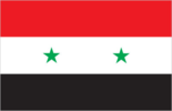
Flag description
three equal horizontal bands of red (top), white, and black, with two small green five-pointed stars in a horizontal line centered in the white band; similar to the flag of Yemen, which has a plain white band, and of Iraq, which has three green stars (plus an Arabic inscription) in a horizontal line centered in the white band; also similar to the flag of Egypt, which has a heraldic eagle centered in the white band Economy Syria
GDP
purchasing power parity - $63.48 billion (2002 est.)
GDP - composition by sector
- agriculture
- 27%
- industry
- 23%
- services
- 50% (2000 est.)
GDP - per capita
purchasing power parity - $3,700 (2002 est.)
GDP - real growth rate
3.6% (2002 est.)
Geographic coordinates
35 00 N, 38 00 E
Geography - note
there are 42 Israeli settlements and civilian land use sites in the Israeli-occupied Golan Heights (February 2002 est.) People Syria
Government type
republic under military regime since March 1963
Heliports
7 (2002) Military Syria
Highways
- paved
- 10,021 km (including 877 km of expressways)
- total
- 43,381 km
- unpaved
- 33,360 km (1999)
HIV/AIDS - adult prevalence rate
0.01% (2001 est.)
HIV/AIDS - deaths
NA
HIV/AIDS - people living with HIV/AIDS
NA
Household income or consumption by percentage share
- highest 10%
- NA%
- lowest 10%
- NA%
Illicit drugs
a transit point for opiates and hashish bound for regional and Western markets This page was last updated on 18 December, 2003
Imports
$4.9 billion f.o.b. (2002 est.)
Imports - commodities
machinery and transport equipment 21%, food and livestock 18%, metal and metal products 15%, chemicals and chemical products 10% (2000 est.)
Imports - partners
Italy 8.3%, Germany 7.4%, China 5.7%, South Korea 4.8%, France 4.6%, US 4.4%, Turkey 4.1% (2002)
Independence
17 April 1946 (from League of Nations mandate under French administration)
Industrial production growth rate
NA%
Industries
petroleum, textiles, food processing, beverages, tobacco, phosphate rock mining
Infant mortality rate
- female
- 31.43 deaths/1,000 live births (2003 est.)
- male
- 31.89 deaths/1,000 live births
- total
- 31.67 deaths/1,000 live births
Inflation rate (consumer prices)
0.9% (2002 est.)
International organization participation
AFESD, AL, AMF, CAEU, ESCWA, FAO, G-24, G-77, IAEA, IBRD, ICAO, ICC, ICCt (signatory), ICRM, IDA, IDB, IFAD, IFC, IFRCS, IHO, ILO, IMF, IMO, Interpol, IOC, ISO, ITU, NAM, OAPEC, OIC, UN, UN Security Council (temporary), UNCTAD, UNESCO, UNIDO, UNRWA, UPU, WCO, WFTU, WHO, WMO, WToO
Internet country code
.sy
Internet Service Providers (ISPs)
1 (2000)
Internet users
60,000 (2002) Transportation Syria
Irrigated land
12,130 sq km (1998 est.)
Judicial branch
Supreme Constitutional Court (justices are appointed for four-year terms by the president); High Judicial Council; Court of Cassation; State Security Courts
Labor force
5.2 million (2000 est.)
Labor force - by occupation
agriculture, industry, services NA (2002)
Land boundaries
- border countries
- Iraq 605 km, Israel 76 km, Jordan 375 km, Lebanon 375 km, Turkey 822 km
- total
- 2,253 km
Land use
- arable land
- 25.96%
- other
- 69.96% (1998 est.)
- permanent crops
- 4.08%
Languages
Arabic (official); Kurdish, Armenian, Aramaic, Circassian widely understood; French, English somewhat understood
Legal system
based on Islamic law and civil law system; special religious courts; has not accepted compulsory ICJ jurisdiction
Legislative branch
- unicameral People's Council or Majlis al-shaab (250 seats; members elected by popular vote to serve four-year terms)
- election results
- percent of vote by party - NPF 67%, independents 33%; seats by party - NPF 167, independents 83; note - the constitution guarantees that the Ba'th Party (part of the NPF alliance) receives one-half of the seats
- elections
- last held 2-3 March 2003 (next to be held NA 2007)
Life expectancy at birth
- female
- 70.67 years (2003 est.)
- male
- 68.18 years
- total population
- 69.39 years
Literacy
- definition
- age 15 and over can read and write
- female
- 64% (2003 est.) Government Syria
- male
- 89.7%
- total population
- 76.9%
Location
Middle East, bordering the Mediterranean Sea, between Lebanon and Turkey
Map references
Middle East
Maritime claims
- contiguous zone
- 41 NM
- territorial sea
- 35 NM
Median age
- female
- 19.9 years (2002)
- male
- 19.6 years
- total
- 19.7 years
Merchant marine
- convenience
- Egypt 1, Greece 2, Italy 1, Lebanon 10 (2002 est.)
- note
- includes some foreign-owned ships registered here as a flag of
- ships by type
- bulk 13, cargo 109, container 2, livestock carrier 3, refrigerated cargo 1, roll on/roll off 1
- total
- 129 ships (1,000 GRT or over) 450,135 GRT/645,296 DWT
Military branches
Syrian Arab Army, Syrian Arab Navy, Syrian Arab Air Force (includes Air Defense Forces), Police and Security Force
Military expenditures - dollar figure
$858 million (FY00 est.); note - based on official budget data that may understate actual spending
Military expenditures - percent of GDP
5.9% (FY00) Transnational Issues Syria
Military manpower - availability
- males age 15-49
- 4,715,386 (2003 est.)
Military manpower - fit for military service
- males age 15-49
- 2,629,148 (2003 est.)
Military manpower - military age
19 years of age (2003 est.)
Military manpower - reaching military age annually
- males
- 210,941 (2003 est.)
National holiday
Independence Day, 17 April (1946)
Nationality
- adjective
- Syrian
- noun
- Syrian(s)
Natural gas - consumption
5.84 billion cu m (2001 est.)
Natural gas - exports
0 cu m (2001 est.)
Natural gas - imports
0 cu m (2001 est.)
Natural gas - production
5.84 billion cu m (2001 est.)
Natural gas - proved reserves
240.7 billion cu m (37257)
Natural hazards
dust storms, sandstorms
Natural resources
petroleum, phosphates, chrome and manganese ores, asphalt, iron ore, rock salt, marble, gypsum, hydropower
Net migration rate
0 migrant(s)/1,000 population (2003 est.)
Oil - consumption
265,000 bbl/day (2001 est.)
Oil - exports
NA (2001)
Oil - imports
NA (2001)
Oil - production
522,700 bbl/day (2001 est.)
Oil - proved reserves
2.4 billion bbl (37257)
Pipelines
gas 2,300 km; oil 2,183 km (2003)
Political parties and leaders
National Progressive Front or NPF (includes Arab Socialist Renaissance (Ba'th) Party (governing party) [President Bashar al-ASAD, secretary general], Socialist Unionist Democratic Party [Ahmad al ASAD], Syrian Communist Party [leader NA], Unionist Socialist Party [leader NA], Arab Socialist Party [Abd al-Ghani QANNUT], and Arab Socialist Unionist Movement [Sami SUFAN]) [President Bashar al-ASAD, chairman]; Syrian Arab Socialist Party or ASP [Safwan QUDSI]; Syrian Communist Party or SCP [Yusuf FAYSAL]; Syrian Social National Party [Jubran URAYJI]
Political pressure groups and leaders
conservative religious leaders; Muslim Brotherhood (operates in exile in Jordan and Yemen); non-Ba'th parties have little effective political influence
Population
- 17,585,540 (July 2002 est.)
- note
- in addition, about 40,000 people live in the Israeli-occupied Golan Heights - 20,000 Arabs (18,000 Druze and 2,000 Alawites) and about 20,000 Israeli settlers (February 2003 est.) (July 2003 est.)
Population below poverty line
15%-25%
Population growth rate
2.45% (2003 est.)
Ports and harbors
Baniyas, Jablah, Latakia, Tartus
Radio broadcast stations
AM 14, FM 2, shortwave 1 (1998)
Radios
4.15 million (1997)
Railways
- narrow gauge
- 318 km 1.050-m gauge (2002)
- standard gauge
- 2,425 km 1.435-m gauge
- total
- 2,743 km
Religions
Sunni Muslim 74%, Alawite, Druze, and other Muslim sects 16%, Christian (various sects) 10%, Jewish (tiny communities in Damascus, Al Qamishli, and Aleppo)
Sex ratio
- at birth
- 1.06 male(s)/female
- total population
- 1.05 male(s)/female (2003 est.)
- under 15 years
- 1.06 male(s)/female 15-64 years: 1.05 male(s)/female 65 years and over: 0.93 male(s)/female
Suffrage
18 years of age; universal
Syrian pounds per US dollar - (Official rate)
- 11.23 (2002), 11.23 (2001), 11.23 (2000), 11.23 (1999), 11.23 (1998), (Free market
- rate)
- 49.65 (2001), 49.4 (2000), 51.7 (1999), 52 (1998)
Telephone system
- domestic
- coaxial cable and microwave radio relay network
- general assessment
- fair system currently undergoing significant improvement and digital upgrades, including fiber-optic technology
- international
- satellite earth stations - 1 Intelsat (Indian Ocean) and 1 Intersputnik (Atlantic Ocean region); 1 submarine cable; coaxial cable and microwave radio relay to Iraq, Jordan, Lebanon, and Turkey; participant in Medarabtel
Telephones - main lines in use
1.313 million (1997)
Telephones - mobile cellular
NA
Television broadcast stations
44 (plus 17 repeaters) (1995)
Televisions
1.05 million (1997)
Terrain
primarily semiarid and desert plateau; narrow coastal plain; mountains in west
Total fertility rate
3.72 children born/woman (2003 est.)
Unemployment rate
20% (2002 est.)
Waterways
870 km (minimal economic importance)