2012 Edition
CIA World Factbook 2012 Archive (HTML)
Introduction
Background
First explored by the Spaniards in the 16th century and then settled by the English in the mid-17th century, Suriname became a Dutch colony in 1667. With the abolition of slavery in 1863, workers were brought in from India and Java. Independence from the Netherlands was granted in 1975. Five years later the civilian government was replaced by a military regime that soon declared a socialist republic. It continued to exert control through a succession of nominally civilian administrations until 1987, when international pressure finally forced a democratic election. In 1990, the military overthrew the civilian leadership, but a democratically elected government - a four-party coalition - returned to power in 1991. The coalition expanded to eight parties in 2005 and ruled until August 2010, when voters returned former military leader Desire BOUTERSE and his opposition coalition to power.
Geography
Area
- 163,820 sq km 156,000 sq km 7,820 sq km
- total
- 163,820 sq km
- water
- 7,820 sq km
Area - comparative
slightly larger than Georgia
Climate
tropical; moderated by trade winds
Coastline
386 km
Elevation extremes
- unnamed location in the coastal plain -2 m Juliana Top 1,230 m
- highest point
- Juliana Top 1,230 m
- lowest point
- unnamed location in the coastal plain -2 m
Environment - current issues
deforestation as timber is cut for export; pollution of inland waterways by small-scale mining activities
Environment - international agreements
- Biodiversity, Climate Change, Climate Change-Kyoto Protocol, Desertification, Endangered Species, Law of the Sea, Marine Dumping, Ozone Layer Protection, Ship Pollution, Tropical Timber 94, Wetlands, Whaling none of the selected agreements
- party to
- Biodiversity, Climate Change, Climate Change-Kyoto Protocol, Desertification, Endangered Species, Law of the Sea, Marine Dumping, Ozone Layer Protection, Ship Pollution, Tropical Timber 94, Wetlands, Whaling
- signed, but not ratified
- none of the selected agreements
Freshwater withdrawal (domestic/industrial/agricultural)
- 0.67 cu km/yr (4%/3%/93%) 1,489 cu m/yr (2000)
- per capita
- 1,489 cu m/yr (2000)
- total
- 0.67 cu km/yr (4%/3%/93%)
Geographic coordinates
4 00 N, 56 00 W
Geography - note
smallest independent country on South American continent; mostly tropical rain forest; great diversity of flora and fauna that, for the most part, is increasingly threatened by new development; relatively small population, mostly along the coast
Irrigated land
510 sq km (2003)
Land boundaries
- 1,703 km Brazil 593 km, French Guiana 510 km, Guyana 600 km
- border countries
- Brazil 593 km, French Guiana 510 km, Guyana 600 km
- total
- 1,703 km
Land use
- 0.36% 0.06% 99.58% (2005)
- arable land
- 0.36%
- other
- 99.58% (2005)
- permanent crops
- 0.06%
Location
Northern South America, bordering the North Atlantic Ocean, between French Guiana and Guyana
Map references
South America
Maritime claims
- 12 nm 200 nm
- exclusive economic zone
- 200 nm
- territorial sea
- 12 nm
Natural hazards
NA
Natural resources
timber, hydropower, fish, kaolin, shrimp, bauxite, gold, and small amounts of nickel, copper, platinum, iron ore
Terrain
mostly rolling hills; narrow coastal plain with swamps
Total renewable water resources
122 cu km (2003)
People and Society
Age structure
- 27.5% (male 78,366/ female 75,401) 67% (male 190,138/ female 185,021) 5.6% (male 13,562/ female 17,669) (2012 est.)
- 0-14 years
- 27.5% (male 78,366/ female 75,401)
- 15-64 years
- 67% (male 190,138/ female 185,021)
- 65 years and over
- 5.6% (male 13,562/ female 17,669) (2012 est.)
Birth rate
17.44 births/1,000 population (2012 est.)
Death rate
6.17 deaths/1,000 population (July 2012 est.)
Demographic profile
Suriname is a pluralistic society consisting primarily of Creoles (persons of mixed African and European heritage), the descendants of escaped African slaves known as Maroons, and the descendants of Indian and Javanese contract workers. The country overall is in full, post-industrial demographic transition, with a low fertility rate, a moderate mortality rate, and a rising life expectancy. However, the Maroon population of the rural interior lags behind because of lower educational attainment and contraceptive use, higher malnutrition, and significantly less access to electricity, potable water, sanitation, infrastructure, and health care. Some 350,000 people of Surinamese descent live in the Netherlands, Suriname's former colonial ruler. In the 19th century, better-educated, largely Dutch-speaking Surinamese began emigrating to the Netherlands. World War II interrupted the outflow, but it resumed after the war when Dutch labor demands grew - emigrants included all segments of the Creole population. Suriname still is strongly influenced by the Netherlands because most Surinamese have relatives living there and it is the largest supplier of development aid. Other emigration destinations include French Guiana and the United States. Suriname's immigration rules are flexible, and the country is easy to enter illegally because rainforests obscure its borders. Since the mid-1980s, Brazilians have settled in Suriname's capital, Paramaribo, or eastern Suriname, where they mine gold. This immigration is likely to slowly re-orient Suriname toward its Latin American roots.
Education expenditures
NA
Ethnic groups
Hindustani (also known locally as "East Indians"; their ancestors emigrated from northern India in the latter part of the 19th century) 37%, Creole (mixed white and black) 31%, Javanese 15%, "Maroons" (their African ancestors were brought to the country in the 17th and 18th centuries as slaves and escaped to the interior) 10%, Amerindian 2%, Chinese 2%, white 1%, other 2%
Health expenditures
7.6% of GDP (2009)
HIV/AIDS - adult prevalence rate
1% (2009 est.)
HIV/AIDS - deaths
fewer than 200 (2009 est.)
HIV/AIDS - people living with HIV/AIDS
3,700 (2009 est.)
Hospital bed density
3.1 beds/1,000 population (2007)
Infant mortality rate
- 28.94 deaths/1,000 live births 33.62 deaths/1,000 live births 24.03 deaths/1,000 live births (2012 est.)
- female
- 24.03 deaths/1,000 live births (2012 est.)
- total
- 28.94 deaths/1,000 live births
Languages
Dutch (official), English (widely spoken), Sranang Tongo (Surinamese, sometimes called Taki-Taki, is native language of Creoles and much of the younger population and is lingua franca among others), Caribbean Hindustani (a dialect of Hindi), Javanese
Life expectancy at birth
- 71.12 years 68.78 years 73.58 years (2012 est.)
- female
- 73.58 years (2012 est.)
- total population
- 71.12 years
Literacy
- age 15 and over can read and write 89.6% 92% 87.2% (2004 census)
- definition
- age 15 and over can read and write
- female
- 87.2% (2004 census)
- male
- 92%
- total population
- 89.6%
Major cities - population
PARAMARIBO (capital) 259,000 (2009)
Major infectious diseases
- high bacterial and protozoal diarrhea, hepatitis A, and typhoid fever dengue fever, Mayaro virus, and malaria leptospirosis (2009)
- degree of risk
- high
- food or waterborne diseases
- bacterial and protozoal diarrhea, hepatitis A, and typhoid fever
- vectorborne disease
- dengue fever, Mayaro virus, and malaria
- water contact disease
- leptospirosis (2009)
Maternal mortality rate
130 deaths/100,000 live births (2010)
Median age
- 27.6 years 27.3 years 28 years (2012 est.)
- female
- 28 years (2012 est.)
- male
- 27.3 years
- total
- 27.6 years
Nationality
- Surinamer(s) Surinamese
- adjective
- Surinamese
- noun
- Surinamer(s)
Net migration rate
0.96 migrant(s)/1,000 population (2012 est.)
Physicians density
0.45 physicians/1,000 population (2000)
Population
560,157 (July 2012 est.)
Population growth rate
1.222% (2012 est.)
Religions
Hindu 27.4%, Protestant 25.2% (predominantly Moravian), Roman Catholic 22.8%, Muslim 19.6%, indigenous beliefs 5%
Sanitation facility access
- urban: 90% of population rural: 66% of population total: 84% of population urban: 10% of population rural: 34% of population total: 16% of population
- rural
- 34% of population
- total
- 16% of population
- urban
- 10% of population
School life expectancy (primary to tertiary education)
- 13 years (2006)
- total
- 13 years (2006)
Sex ratio
- 1.05 male(s)/female 1.04 male(s)/female 1.03 male(s)/female 0.77 male(s)/female 1.01 male(s)/female (2011 est.)
- 15-64 years
- 1.03 male(s)/female
- 65 years and over
- 0.77 male(s)/female
- at birth
- 1.05 male(s)/female
- total population
- 1.01 male(s)/female (2011 est.)
- under 15 years
- 1.04 male(s)/female
Total fertility rate
2.08 children born/woman (2012 est.)
Unemployment, youth ages 15-24
- 21.5% (2004)
- total
- 21.5% (2004)
Urbanization
- 69% of total population (2010) 1.5% annual rate of change (2010-15 est.)
- rate of urbanization
- 1.5% annual rate of change (2010-15 est.)
- urban population
- 69% of total population (2010)
Government
Administrative divisions
10 districts (distrikten, singular - distrikt); Brokopondo, Commewijne, Coronie, Marowijne, Nickerie, Para, Paramaribo, Saramacca, Sipaliwini, Wanica
Capital
- Paramaribo 5 50 N, 55 10 W UTC-3 (2 hours ahead of Washington, DC during Standard Time)
- geographic coordinates
- 5 50 N, 55 10 W
- name
- Paramaribo
- time difference
- UTC-3 (2 hours ahead of Washington, DC during Standard Time)
Constitution
ratified 30 September 1987; effective 30 October 1987
Country name
- Republic of Suriname Suriname Republiek Suriname Suriname Netherlands Guiana, Dutch Guiana
- conventional long form
- Republic of Suriname
- conventional short form
- Suriname
- former
- Netherlands Guiana, Dutch Guiana
- local long form
- Republiek Suriname
- local short form
- Suriname
Diplomatic representation from the US
- Ambassador Jay N. ANANIA Dr. Sophie Redmondstraat 129, Paramaribo US Department of State, PO Box 1821, Paramaribo [597] 472-900 [597] 410-025
- chief of mission
- Ambassador Jay N. ANANIA
- embassy
- Dr. Sophie Redmondstraat 129, Paramaribo
- FAX
- [597] 410-025
- mailing address
- US Department of State, PO Box 1821, Paramaribo
- telephone
- [597] 472-900
Diplomatic representation in the US
- Ambassador Subhas-Chandra MUNGRA Suite 460, 4301 Connecticut Avenue NW, Washington, DC 20008 [1] (202) 244-7488 [1] (202) 244-5878 Miami
- chancery
- Suite 460, 4301 Connecticut Avenue NW, Washington, DC 20008
- chief of mission
- Ambassador Subhas-Chandra MUNGRA
- consulate(s) general
- Miami
- FAX
- [1] (202) 244-5878
- telephone
- [1] (202) 244-7488
Executive branch
- President Desire Delano BOUTERSE (since 12 August 2010); Vice President Robert AMEERALI (since 12 August 2010); note - the president is both the chief of state and head of government President Desire Delano BOUTERSE (since 12 August 2010); Vice President Robert AMEERALI (since 12 August 2010) Cabinet of Ministers appointed by the president president and vice president elected by the National Assembly or, if no presidential or vice presidential candidate receives a two-thirds constitutional majority in the National Assembly after two votes, by a simple majority in the larger United People's Assembly (893 representatives from the national, local, and regional councils), for five-year terms (no term limits); election last held on 19 July 2010 (next to be held in 2015) Desire Delano BOUTERSE elected president; percent of vote - Desire Delano BOUTERSE 70.6%, Chandrikapersad SATOKHI 25.5%, other 3.9%
- cabinet
- Cabinet of Ministers appointed by the president
- chief of state
- President Desire Delano BOUTERSE (since 12 August 2010); Vice President Robert AMEERALI (since 12 August 2010); note - the president is both the chief of state and head of government
- election results
- Desire Delano BOUTERSE elected president; percent of vote - Desire Delano BOUTERSE 70.6%, Chandrikapersad SATOKHI 25.5%, other 3.9%
- elections
- president and vice president elected by the National Assembly or, if no presidential or vice presidential candidate receives a two-thirds constitutional majority in the National Assembly after two votes, by a simple majority in the larger United People's Assembly (893 representatives from the national, local, and regional councils), for five-year terms (no term limits); election last held on 19 July 2010 (next to be held in 2015)
- head of government
- President Desire Delano BOUTERSE (since 12 August 2010); Vice President Robert AMEERALI (since 12 August 2010)
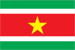
Flag description
five horizontal bands of green (top, double width), white, red (quadruple width), white, and green (double width); a large, yellow, five-pointed star is centered in the red band; red stands for progress and love; green symbolizes hope and fertility; white signifies peace, justice, and freedom; the star represents the unity of all ethnic groups; from its yellow light the nation draws strength to bear sacrifices patiently while working toward a golden future
Government type
constitutional democracy
Independence
25 November 1975 (from the Netherlands)
International law organization participation
accepts compulsory ICJ jurisdiction with reservations; accepts ICCt jurisdiction
International organization participation
ACP, AOSIS, Caricom, CD, CELAC, FAO, G-77, IADB, IBRD, ICAO, ICRM, IDA, IDB, IFAD, IFRCS, IHO, ILO, IMF, IMO, Interpol, IOC, IPU, ISO (correspondent), ITU, ITUC (NGOs), LAES, MIGA, NAM, OAS, OIC, OPANAL, OPCW, PCA, Petrocaribe, UN, UNASUR, UNCTAD, UNESCO, UNIDO, UPU, WHO, WIPO, WMO, WTO
Judicial branch
Cantonal Courts and a Court of Justice as an appellate court (justices are nominated for life); member of the Caribbean Court of Justice (CCJ)
Legal system
civil law system influenced by Dutch civil law; note - the Commissie Nieuw Surinaamse Burgerlijk Wetboek completed drafting a new civil code in February 2009
Legislative branch
- unicameral National Assembly or Nationale Assemblee (51 seats; members elected by popular vote to serve five-year terms) last held on 25 May 2010 (next to be held in May 2015) percent of vote by party - Mega Combination 45.1%, New Front 27.5%, A-Com 13.7%, People's Alliance 11.8%, DOE 1.9%; seats by party - Mega Combination 23, New Front 14, A-Com 7, People's Alliance 6, DOE 1
- election results
- percent of vote by party - Mega Combination 45.1%, New Front 27.5%, A-Com 13.7%, People's Alliance 11.8%, DOE 1.9%; seats by party - Mega Combination 23, New Front 14, A-Com 7, People's Alliance 6, DOE 1
- elections
- last held on 25 May 2010 (next to be held in May 2015)
National anthem
- "God zij met ons Suriname!" (God Be With Our Suriname) Cornelis Atses HOEKSTRA and Henry DE ZIEL/Johannes Corstianus DE PUY adopted 1959; the anthem, originally adapted from a Sunday school song written in 1893, contains lyrics in both Dutch and Sranang Tongo
- lyrics/music
- Cornelis Atses HOEKSTRA and Henry DE ZIEL/Johannes Corstianus DE PUY
- name
- "God zij met ons Suriname!" (God Be With Our Suriname)
National holiday
Independence Day, 25 November (1975)
Political parties and leaders
A-Combination (a coalition that includes the General Liberation and Development Party ABOP [Ronnie BRUNSWIJK], and SEEKA [Paul ABENA]); Basic Party for Renewal and Democracy or BVD [Dilip SARDJOE]; Basic Party for Renewal and Democracy or PVF [Soedeschand JAIRAM]; Democratic Union Suriname or DUS [Japhet DIEKO]; Mega Combination Coalition (a coalition that joined with A-Combination and the PL to form a majority in Parliament in 2010 - includes the National Democratic Party or NDP [Desire BOUTERSE] (largest party in the coalition), Progressive Worker and Farmer's Union or PALU [Jim HOK], Party for National Unity and Solidarity of the Highest Order or KTPI [Willy SOEMITA], DNP-2000 [Jules WIJDENBOSCH], Union of Brotherhood and Unity in Politics BEP [Caprino ALENDY], and New Suriname or NS [Nanan PANDAY]); National Union or NU [P. VAN LEEUWAARDE]; New Front for Democracy and Development or NF (a coalition made up of the National Party of Suriname or NPS [Runaldo VENETIAAN], United Reform Party or VHP [Ramdien SARDJOE], Democratic Alternative 1991 or DA-91 - an independent, business-oriented party [Winston JESSURUN], Surinamese Labor Party or SPA [Siegfried GILDS]); Party for Democracy and Development in Unity or DOE [Carl BREEVELD]; Party for the Permanent Prosperity Republic Suriname or PVRS [NA]; People's Alliance, Pertjaja Luhur's or PL [Paul SOMOHARDJO](includes D-21 [Soewarta MOESTADJA] and Pendawa Lima [Raymond SAPEON], which merged with PL in 2010) BVD and PVF participated in the elections as a coalition (BVD/PVF) in the most recent elections, but separated after the election
Political pressure groups and leaders
Association of Indigenous Village Chiefs [Ricardo PANE]; Association of Saramaccan Authorities or Maroon [Head Captain WASE]; Women's Parliament Forum or PVF [Iris GILLIAD]
Suffrage
18 years of age; universal
Economy
Agriculture - products
rice, bananas, palm kernels, coconuts, plantains, peanuts; beef, chickens; shrimp; forest products
Budget
- $826.6 million $939.7 million (2010 est.)
- expenditures
- $939.7 million (2010 est.)
- revenues
- $826.6 million
Budget surplus (+) or deficit (-)
-2.2% of GDP (2010 est.)
Commercial bank prime lending rate
12% (31 December 2012 est.) 11.75% (31 December 2011 est.)
Current account balance
$577.2 million (2012 est.) $251.1 million (2011 est.)
Debt - external
$504.3 million (2005 est.)
Economy - overview
The economy is dominated by the mining industry, with exports of alumina, gold, and oil accounting for about 85% of exports and 25% of government revenues, making the economy highly vulnerable to mineral price volatility. Economic growth, which reached about 7% in 2008, owing to sizeable foreign investment in mining and oil, slowed to 2.2% in 2009 as investment waned and the country earned less from its commodity exports when global prices for most commodities fell. Trade picked up, boosting Suriname's economic growth about 4% per year in 2010-12, but the government's budget remained strained. Inflation rose from 1.3% in 2009 to 17.7% in 2011. In January 2011, the government devalued the currency by 20% and raised taxes to reduce the budget deficit. As a result of these measures, inflation receded to 6% in 2012. Suriname's economic prospects for the medium term will depend on continued commitment to responsible monetary and fiscal policies and to the introduction of structural reforms to liberalize markets and promote competition.
Exchange rates
Surinamese dollars (SRD) per US dollar - 3.5 (2012 est.) 3.2683 (2011 est.) 2.7454 (2010 est.) 2.745 (2009) 2.745 (2008)
Exports
$2.927 billion (2012 est.) $2.467 billion (2011 est.)
Exports - commodities
alumina, gold, crude oil, lumber, shrimp and fish, rice, bananas
Exports - partners
US 23.9%, Canada 19.5%, Belgium 17.2%, UAE 8.9%, Norway 6.2%, Guyana 4.8%, France 4.1% (2011)
Fiscal year
calendar year
GDP - composition by sector
- 10.4% 36.6% 52.9% (2012 est.)
- agriculture
- 10.4%
- industry
- 36.6%
- services
- 52.9% (2012 est.)
GDP - per capita (PPP)
$12,300 (2012 est.) $11,900 (2011 est.) $11,600 (2010 est.) data are in 2012 US dollars
GDP - real growth rate
4% (2012 est.) 4.2% (2011 est.) 4.1% (2010 est.)
GDP (official exchange rate)
$5.094 billion (2012 est.)
GDP (purchasing power parity)
$6.685 billion (2012 est.) $6.429 billion (2011 est.) $6.173 billion (2010 est.) data are in 2012 US dollars
Household income or consumption by percentage share
- NA% NA%
- highest 10%
- NA%
- lowest 10%
- NA%
Imports
$1.838 billion (2012 est.) $1.679 billion (2011 est.)
Imports - commodities
capital equipment, petroleum, foodstuffs, cotton, consumer goods
Imports - partners
US 26.1%, Netherlands 15.6%, UAE 8.6%, China 8.2%, Antigua and Barbuda 7.4%, Netherlands Antilles 5.5%, Brazil 4.4%, Japan 4.1% (2011)
Industrial production growth rate
6.5% (1994 est.)
Inflation rate (consumer prices)
6% (2012 est.) 17.7% (2011 est.)
Labor force
165,600 (2007)
Labor force - by occupation
- 8% 14% 78% (2004)
- agriculture
- 8%
- industry
- 14%
- services
- 78% (2004)
Market value of publicly traded shares
$NA
Population below poverty line
70% (2002 est.)
Reserves of foreign exchange and gold
$1.048 billion (31 December 2011 est.) $726.8 million (2010 est.)
Stock of broad money
$2.3 billion (31 December 2012 est.) $2.033 billion (31 December 2011 est.)
Stock of domestic credit
$1.286 billion (31 December 2012 est.) $1.029 billion (31 December 2011 est.)
Stock of narrow money
$1.132 billion (31 December 2012 est.) $1.075 billion (31 December 2011 est.)
Taxes and other revenues
16.2% of GDP (2010 est.)
Unemployment rate
9% (2008) 12.1% (2006)
Energy
Carbon dioxide emissions from consumption of energy
2.343 million Mt (2010 est.)
Crude oil - exports
0 bbl/day (2009 est.)
Crude oil - imports
0 bbl/day (2009 est.)
Crude oil - production
16,000 bbl/day (2011 est.)
Crude oil - proved reserves
72 million bbl (1 January 2012 est.)
Electricity - consumption
1.463 billion kWh (2009 est.)
Electricity - exports
0 kWh (2010 est.)
Electricity - from fossil fuels
51.4% of total installed capacity (2009 est.)
Electricity - from hydroelectric plants
48.6% of total installed capacity (2009 est.)
Electricity - from nuclear fuels
0% of total installed capacity (2009 est.)
Electricity - from other renewable sources
0% of total installed capacity (2009 est.)
Electricity - imports
0 kWh (2010 est.)
Electricity - installed generating capacity
389,000 kW (2009 est.)
Electricity - production
1.603 billion kWh (2009 est.)
Natural gas - consumption
0 cu m (2010 est.)
Natural gas - exports
0 cu m (2010 est.)
Natural gas - imports
0 cu m (2010 est.)
Natural gas - production
0 cu m (2010 est.)
Natural gas - proved reserves
0 cu m (1 January 2011 est.)
Refined petroleum products - consumption
14,100 bbl/day (2011 est.)
Refined petroleum products - exports
1,058 bbl/day (2008 est.)
Refined petroleum products - imports
6,430 bbl/day (2008 est.)
Refined petroleum products - production
7,407 bbl/day (2008 est.)
Communications
Broadcast media
2 state-owned TV stations; 1 state-owned radio station; multiple private radio and TV stations (2007)
Internet country code
.sr
Internet hosts
188 (2012)
Internet users
163,000 (2009)
Telephone system
- international facilities are good combined fixed-line and mobile-cellular teledensity 185 telephones per 100 persons; microwave radio relay network country code - 597; satellite earth stations - 2 Intelsat (Atlantic Ocean)
- domestic
- combined fixed-line and mobile-cellular teledensity 185 telephones per 100 persons; microwave radio relay network
- general assessment
- international facilities are good
- international
- country code - 597; satellite earth stations - 2 Intelsat (Atlantic Ocean)
Telephones - main lines in use
85,500 (2011)
Telephones - mobile cellular
947,000 (2011)
Transportation
Airports
47 (2012)
Airports - with paved runways
- 4 (2012)
- over 3,047 m
- 1
- total
- 5
- under 914 m
- 4 (2012)
Airports - with unpaved runways
- 38 (2012)
- 914 to 1,523 m
- 4
- total
- 42
- under 914 m
- 38 (2012)
Pipelines
oil 50 km (2010)
Ports and terminals
Paramaribo, Wageningen
Roadways
- 4,304 km 1,130 km 3,174 km (2003)
- total
- 4,304 km
- unpaved
- 3,174 km (2003)
Waterways
1,200 km (most navigable by ships with drafts up to 7 m) (2011)
Military and Security
Manpower available for military service
- 134,218 134,439 (2010 est.)
- females age 16-49
- 134,439 (2010 est.)
- males age 16-49
- 134,218
Manpower fit for military service
- 109,445 112,538 (2010 est.)
- females age 16-49
- 112,538 (2010 est.)
- males age 16-49
- 109,445
Manpower reaching militarily significant age annually
- 4,119 4,106 (2010 est.)
- female
- 4,106 (2010 est.)
- male
- 4,119
Military branches
- Suriname Armed Forces: Ground Forces, Naval Forces, Air Forces (2010)
- Suriname Armed Forces
- Ground Forces, Naval Forces, Air Forces (2010)
Military expenditures
0.6% of GDP (2006 est.)
Military service age and obligation
18 years of age (est.); recruitment is voluntary, with personnel drawn almost exclusively from the Creole community (2007)
Transnational Issues
Disputes - international
area claimed by French Guiana between Riviere Litani and Riviere Marouini (both headwaters of the Lawa); Suriname claims a triangle of land between the New and Kutari/Koetari rivers in a historic dispute over the headwaters of the Courantyne; Guyana seeks United Nations Convention on the Law of the Sea arbitration to resolve the longstanding dispute with Suriname over the axis of the territorial sea boundary in potentially oil-rich waters
Illicit drugs
growing transshipment point for South American drugs destined for Europe via the Netherlands and Brazil; transshipment point for arms-for-drugs dealing