2003 Edition
CIA World Factbook 2003 (Project Gutenberg)
Introduction
Administrative divisions
10 districts (distrikten, singular - distrikt); Brokopondo, Commewijne, Coronie, Marowijne, Nickerie, Para, Paramaribo, Saramacca, Sipaliwini, Wanica
Age structure
0-14 years: 30.7% (male 68,536; female 65,165) 15-64 years: 63.3% (male 141,048; female 134,699) 65 years and over: 6% (male 11,686; female 14,315) (2003 est.)
Area
- land
- 161,470 sq km
- total
- 163,270 sq km
- water
- 1,800 sq km
Area - comparative
slightly larger than Georgia
Background
Independence from the Netherlands was granted in 1975. Five years later the civilian government was replaced by a military regime that soon declared a socialist republic. It continued to rule through a succession of nominally civilian administrations until 1987, when international pressure finally forced a democratic election. In 1989, the military overthrew the civilian government, but a democratically-elected government returned to power in 1991. Geography Suriname
Birth rate
19.4 births/1,000 population (2003 est.)
Capital
Paramaribo
Climate
tropical; moderated by trade winds
Coastline
386 km
Constitution
ratified 30 September 1987
Country name
- conventional long form
- Republic of Suriname
- conventional short form
- Suriname
- former
- Netherlands Guiana, Dutch Guiana
- local long form
- Republiek Suriname
- local short form
- Suriname
Death rate
6.83 deaths/1,000 population (2003 est.)
Elevation extremes
- highest point
- Juliana Top 1,230 m
- lowest point
- unnamed location in the coastal plain -2 m
Environment - current issues
deforestation as timber is cut for export; pollution of inland waterways by small-scale mining activities
Environment - international agreements
- party to
- Biodiversity, Climate Change, Desertification, Endangered Species, Law of the Sea, Marine Dumping, Nuclear Test Ban, Ozone Layer Protection, Ship Pollution, Tropical Timber 94, Wetlands
- signed, but not ratified
- none of the selected agreements
Ethnic groups
Hindustani (also known locally as "East Indians"; their ancestors emigrated from northern India in the latter part of the 19th century) 37%, Creole (mixed white and black) 31%, Javanese 15%, "Maroons" (their African ancestors were brought to the country in the 17th and 18th centuries as slaves and escaped to the interior) 10%, Amerindian 2%, Chinese 2%, white 1%, other 2%
Executive branch
- chief of state
- President Runaldo Ronald VENETIAAN (since 12 August 2000); Vice President Jules Rattankoemar AJODHIA (since 12 August 2000); note - the president is both the chief of state and head of
Geographic coordinates
4 00 N, 56 00 W
Geography - note
smallest independent country on South American continent; mostly tropical rain forest; great diversity of flora and fauna that, for the most part, is increasingly threatened by new development; relatively small population, mostly along the coast People Suriname
Government type
constitutional democracy
HIV/AIDS - adult prevalence rate
1.2% (2001 est.)
HIV/AIDS - deaths
330 (2001 est.)
HIV/AIDS - people living with HIV/AIDS
3,700 (2001 est.)
Independence
25 November 1975 (from Netherlands)
Infant mortality rate
- female
- 20.34 deaths/1,000 live births (2003 est.)
- male
- 28.93 deaths/1,000 live births
- total
- 24.74 deaths/1,000 live births
Irrigated land
490 sq km (1998 est.)
Land boundaries
- border countries
- Brazil 597 km, French Guiana 510 km, Guyana 600 km
- total
- 1,707 km
Land use
- arable land
- 0.37%
- note
- there are 95,000 hectares of arable land, 7,000 hectares of permanent crops, and 15,000 hectares of permanent pastures (1998 est.)
- other
- 99.57%
- permanent crops
- 0.06%
Languages
Dutch (official), English (widely spoken), Sranang Tongo (Surinamese, sometimes called Taki-Taki, is native language of Creoles and much of the younger population and is lingua franca among others), Hindustani (a dialect of Hindi), Javanese
Legal system
based on Dutch legal system incorporating French penal theory
Life expectancy at birth
- female
- 71.78 years (2003 est.)
- male
- 66.79 years
- total population
- 69.23 years
Literacy
- definition
- age 15 and over can read and write
- female
- 91% (1995 est.) Government Suriname
- male
- 95%
- total population
- 93%
Location
Northern South America, bordering the North Atlantic Ocean, between French Guiana and Guyana
Map references
South America
Maritime claims
- exclusive economic zone
- 200 NM
- territorial sea
- 12 NM
Median age
- female
- 26 years (2002)
- male
- 25.1 years
- total
- 25.5 years
National holiday
Independence Day, 25 November (1975)
Nationality
- adjective
- Surinamese
- noun
- Surinamer(s)
Natural hazards
NA
Natural resources
timber, hydropower, fish, kaolin, shrimp, bauxite, gold, and small amounts of nickel, copper, platinum, iron ore
Net migration rate
-8.84 migrant(s)/1,000 population (2003 est.)
Population
435,449 (July 2003 est.)
Population growth rate
0.37% (2003 est.)
Religions
Hindu 27.4%, Muslim 19.6%, Roman Catholic 22.8%, Protestant 25.2% (predominantly Moravian), indigenous beliefs 5%
Sex ratio
- at birth
- 1.05 male(s)/female
- total population
- 1.03 male(s)/female (2003 est.)
- under 15 years
- 1.05 male(s)/female 15-64 years: 1.05 male(s)/female 65 years and over: 0.82 male(s)/female
Suffrage
18 years of age; universal
Terrain
mostly rolling hills; narrow coastal plain with swamps
Total fertility rate
2.4 children born/woman (2003 est.)
Government
Agriculture - products
paddy rice, bananas, palm kernels, coconuts, plantains, peanuts; beef, chickens; forest products; shrimp
Airports
46 (2002)
Airports - with paved runways
- over 3,047 m
- 1
- total
- 5
- under 914 m
- 4 (2002)
Airports - with unpaved runways
- total
- 41 1,524 to 2,437 m: 1 914 to 1,523 m: 5
- under 914 m
- 35 (2002) Military Suriname
Budget
- expenditures
- $403 million, including capital expenditures of $34 million (1997 est.)
- revenues
- $393 million
Currency
Surinamese guilder (SRG)
Currency code
SRG
Debt - external
$321 million (2002 est.)
Diplomatic representation from the US
- chief of mission
- Ambassador Daniel A. JOHNSON
- embassy
- Dr. Sophie Redmondstraat 129, Paramaribo
- mailing address
- Department of State, 3390 Paramaribo Place, Washington, DC, 20521-3390
- telephone
- [597] 472900
Diplomatic representation in the US
- chief of mission
- Ambassador Henry Lothar ILLES
Disputes - international
area disputed by French Guiana between Riviere Litani and Riviere Marouini (both headwaters of the Lawa); area disputed by Guyana between New (Upper Courantyne) and Courantyne/Koetari [Kutari] rivers (all headwaters of the Courantyne); territorial sea boundary with Guyana is in dispute
Economic aid - recipient
Netherlands provided $37 million for project and program assistance, European Development Fund $4 million, Belgium $2 million (1998)
Economy - overview
The economy is dominated by the bauxite industry, which accounts for more than 15% of GDP and 70% of export earnings. Suriname's economic prospects for the medium term will depend on renewed commitment to responsible monetary and fiscal policies and to the introduction of structural reforms to liberalize markets and promote competition. The government of Ronald VENETIAAN has begun an austerity program, raised taxes, and attempted to control spending. However, in 2002, President VENETIAAN agreed to a large pay raise for civil servants, which threatens his earlier gains in stabilizing the economy. The Dutch Government has agreed to restart the aid flow, which will allow Suriname to access international development financing. The short-term economic outlook depends on the government's ability to control inflation and on the development of projects in the bauxite and gold mining sectors.
Electricity - consumption
1.822 billion kWh (2001)
Electricity - exports
0 kWh (2001)
Electricity - imports
0 kWh (2001)
Electricity - production
1.959 billion kWh (2001)
Electricity - production by source
- fossil fuel
- 25.2%
- hydro
- 74.8%
- nuclear
- 0%
- other
- 0% (2001)
Exchange rates
- Surinamese guilders per US dollar - 2,346.75 (2002), 2,178.5 (2001), 1,322.47 (2000), 859.44 (1999), 401 (1998)
- note
- during 1998, the exchange rate splintered into four distinct rates; in January 1999 the government floated the guilder, but subsequently fixed it when the black-market rate plunged; the government currently allows trading within a band of SRG 500 around the official rate
Exports
$445 million f.o.b. (2002)
Exports - commodities
alumina, crude oil, lumber, shrimp and fish, rice, bananas
Exports - partners
US 25.3%, Norway 20.4%, France 8.2%, Trinidad and Tobago 6.4%, Iceland 6%, Canada 5.9%, Netherlands 5.6% (2002)
FAX
- [1] (202) 244-5878
- [597] 420800
- chancery
- Suite 460, 4301 Connecticut Avenue NW, Washington, DC 20008
- consulate(s) general
- Miami
- telephone
- [1] (202) 244-7488
Fiscal year
calendar year Communications Suriname
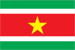
Flag description
five horizontal bands of green (top, double width), white, red (quadruple width), white, and green (double width); there is a large, yellow, five-pointed star centered in the red band Economy Suriname
GDP
purchasing power parity - $1.469 billion (2002 est.)
GDP - composition by sector
- agriculture
- 13%
- industry
- 22%
- services
- 65% (2001 est.)
GDP - per capita
purchasing power parity - $3,400 (2002 est.)
GDP - real growth rate
1.2% (2002 est.)
Highways
- paved
- 1,168 km
- total
- 4,492 km
- unpaved
- 3,324 km (2000)
Household income or consumption by percentage share
- highest 10%
- NA%
- lowest 10%
- NA%
Illicit drugs
growing transshipment point for South American drugs destined for Europe and Brazil; transshipment point for arms-for-drugs dealing This page was last updated on 18 December, 2003
Imports
$300 million f.o.b. (2002)
Imports - commodities
capital equipment, petroleum, foodstuffs, cotton, consumer goods
Imports - partners
US 22.2%, Netherlands 15.6%, China 11.9%, Trinidad and Tobago 11.2%, France 7.5%, Netherlands Antilles 7.2%, Japan 5.7% (2002)
Industrial production growth rate
6.5% (1994 est.)
Industries
bauxite and gold mining, alumina production, oil, lumbering, food processing, fishing
Inflation rate (consumer prices)
17% (2002 est.)
International organization participation
ACP, Caricom, ECLAC, FAO, G-77, IADB, IBRD, ICAO, ICFTU, ICRM, IDB, IFAD, IFRCS, IHO, ILO, IMF, IMO, Interpol, IOC, ITU, LAES, NAM, OAS, OIC, OPANAL, OPCW, PCA, UN, UNCTAD, UNESCO, UNIDO, UPU, WCL, WHO, WIPO, WMO, WTrO
Internet country code
.sr
Internet Service Providers (ISPs)
2 (2000)
Internet users
14,500 (2002) Transportation Suriname
Judicial branch
Court of Justice (justices are nominated for life)
Labor force
100,000
Labor force - by occupation
agriculture NA%, industry NA%, services NA%
Legislative branch
- unicameral National Assembly or Nationale Assemblee (51 seats; members are elected by popular vote to serve five-year terms)
- election results
- percent of vote by party - NA%; seats by party - NF 33, MC 10, DNP 2000 3, DA '91 2, PVF 2, PALU 1
- elections
- last held 5 May 2000 (next to be held NA May 2005)
- note
- widespread demonstrations during the summer of 1999 led to the call for elections a year early
Merchant marine
- ships by type
- cargo 1, container 1 (2002 est.)
- total
- 2 ships (1,000 GRT or over) 2,421 GRT/2,990 DWT
Military branches
National Army (including small Navy and Air Force elements), Civil Police
Military expenditures - dollar figure
$NA
Military expenditures - percent of GDP
1.6% (FY97 est.) Transnational Issues Suriname
Military manpower - availability
- males age 15-49
- 123,159 (2003 est.)
Military manpower - fit for military service
- males age 15-49
- 72,039 (2003 est.)
Natural gas - proved reserves
0 cu m (37257)
Oil - consumption
10,000 bbl/day (2001 est.)
Oil - exports
NA (2001)
Oil - imports
NA (2001)
Oil - production
10,000 bbl/day (2001 est.)
Oil - proved reserves
37 million bbl (37257)
Pipelines
oil 51 km (2003)
Political parties and leaders
Democratic Alternative '91 or DA '91 (a coalition of the Alternative Forum or AF and Party for Brotherhood and Unity in Politics or BEP, formed in January 1991) [Winston JESSURUN]; Democratic National Platform 2000 or DNP 2000 (coalition of two parties, Democratic Party and Democrats of the 21st Century) [Jules WIJDENBOSCH]; Independent Progressive Democratic Alternative or OPDA [Joginder RAMKHILAWAN]; Millennium Combination or MC (a coalition of three parties, Democratic Alternative, Party for National Unity and Solidarity, and National Democratic Party) [leader NA]; National Democratic Party or NDP [Desire BOUTERSE]; Naya Kadam or NK [leader NA]; Party for Renewal and Democracy or BVD [Tjan GOBARDHAN]; Party of National Unity and Solidarity or KTPI [Willy SOEMITA]; Pertjaja Luhur [Paul SOMOHARDJO]; Progressive Workers' and Farm Laborers' Union or PALU [Ir Iwan KROLIS]; The New Front or NF (a coalition of four parties Suriname National Party or NPS, Progressive Reform Party or VHP, Suriname Labor Party or SPA, and Pertjaja Luhur) [Runaldo Ronald VENETIAAN]; The Progressive Development Alliance (a combination of three parties, Renewed Progressive Party or HPP, Party of the Federation of Land Workers or PVF, and Suriname Progressive People's Party or PSV) [Harry KISOENSINGH]
Political pressure groups and leaders
General Liberation and Development Party or ABOP [Ronnie BRUNSWIJK]; Mandela Bushnegro Liberation Movement [Leendert ADAMS]; Tucayana Amazonica [Alex JUBITANA, Thomas SABAJO]; Union for Liberation and Democracy [Kofi AFONGPONG]
Population below poverty line
70% (2002 est.)
Ports and harbors
Albina, Moengo, New Nickerie, Paramaribo, Paranam, Wageningen
Radio broadcast stations
AM 4, FM 13, shortwave 1 (1998)
Radios
300,000 (1997)
Railways
- narrow gauge
- 86 km 1.000-m gauge
- note
- Suriname railroads are not in operation (2001)
- standard gauge
- 80 km 1.435-m gauge
- total
- 166 km (single-track)
Telephone system
- domestic
- microwave radio relay network
- general assessment
- international facilities are good
- international
- satellite earth stations - 2 Intelsat (Atlantic Ocean)
Telephones - main lines in use
64,000 (1997)
Telephones - mobile cellular
4,090 (1997)
Television broadcast stations
3 (plus seven repeaters) (2000)
Televisions
63,000 (1997)
Unemployment rate
17% (2000)
Waterways
- 1,200 km
- note
- most important means of transport; oceangoing vessels with drafts ranging up to 7 m can navigate many of the principal waterways