1996 Edition
CIA World Factbook 1996 (Project Gutenberg)
Introduction
Description
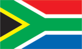
two equal width horizontal bands of red (top) and blue separated by a central green band which splits into a horizontal Y, the arms of which end at the corners of the hoist side, embracing a black isoceles triangle from which the arms are separated by narrow yellow bands; the red and blue bands are separated from the green band and its arms by narrow white stripes
Location
29 00 S, 24 00 E -- Southern Africa, at the southern tip of the continent of Africa Flag ----
Geography
Area
- comparative area
- slightly less than twice the size of Texas
- land area
- 1,219,912 sq km
- note
- includes Prince Edward Islands (Marion Island and Prince Edward Island)
- total area
- 1,219,912 sq km
Climate
mostly semiarid; subtropical along east coast; sunny days, cool nights
Coastline
2,798 km
Environment
- current issues
- lack of important arterial rivers or lakes requires extensive water conservation and control measures; growth in water usage threatens to outpace supply; pollution of rivers from agricultural runoff and urban discharge; air pollution resulting in acid rain; soil erosion; desertification
- international agreements
- party to - Antarctic-Environmental Protocol, Antarctic Treaty, Biodiversity, Endangered Species, Hazardous Wastes, Marine Dumping, Marine Life Conservation, Nuclear Test Ban, Ozone Layer Protection, Ship Pollution, Wetlands, Whaling; signed, but not ratified - Climate Change, Desertification, Law of the Sea
- natural hazards
- prolonged droughts
Geographic coordinates
29 00 S, 24 00 E
Geographic note
South Africa completely surrounds Lesotho and almost completely surrounds Swaziland
International disputes
Swaziland has asked South Africa to open negotiations on reincorporating some nearby South African territories that are populated by ethnic Swazis or that were long ago part of the Swazi Kingdom
Irrigated land
11,280 sq km (1989 est.)
Land boundaries
- border countries
- Botswana 1,840 km, Lesotho 909 km, Mozambique 491 km, Namibia 855 km, Swaziland 430 km, Zimbabwe 225 km
- total
- 4,750 km
Land use
- arable land
- 10%
- forest and woodland
- 3%
- meadows and pastures
- 65%
- other
- 21%
- permanent crops
- 1%
Location
Southern Africa, at the southern tip of the continent of Africa
Map references
Africa
Maritime claims
- continental shelf
- 200-m depth or to the depth of exploitation
- exclusive fishing zone
- 200 nm
- territorial sea
- 12 nm
Natural resources
gold, chromium, antimony, coal, iron ore, manganese, nickel, phosphates, tin, uranium, gem diamonds, platinum, copper, vanadium, salt, natural gas
Terrain
- vast interior plateau rimmed by rugged hills and narrow coastal plain
- highest point
- Njesuthi 3,408 m
- lowest point
- Atlantic Ocean 0 m
People and Society
Age structure
0-14 years: 36% (male 7,578,639; female 7,428,123) 15-64 years: 60% (male 12,356,753; female 12,516,467) 65 years and over: 4% (male 744,806; female 1,118,671) (July 1996 est.)
Birth rate
27.91 births/1,000 population (1996 est.)
Death rate
10.32 deaths/1,000 population (1996 est.)
Ethnic divisions
black 75.2%, white 13.6%, Colored 8.6%, Indian 2.6%
Infant mortality rate
48.8 deaths/1,000 live births (1996 est.)
Languages
11 official languages, including Afrikaans, English, Ndebele, Pedi, Sotho, Swazi, Tsonga, Tswana, Venda, Xhosa, Zulu
Life expectancy at birth
- female
- 61.8 years (1996 est.)
- male
- 57.21 years
- total population
- 59.47 years
Literacy
- age 15 and over can read and write (1995 est.)
- female
- 81.7%
- male
- 81.9%
- total population
- 81.8%
Nationality
- adjective
- South African
- noun
- South African(s)
Net migration rate
0 migrant(s)/1,000 population (1996 est.)
Population
41,743,459 (July 1996 est.)
Population growth rate
1.76% (1996 est.)
Religions
Christian (most whites and Coloreds and about 60% of blacks), Hindu (60% of Indians), Muslim 2%
Sex ratio
- all ages
- 0.98 male(s)/female (1996 est.)
- at birth
- 1.03 male(s)/female
- under 15 years
- 1.02 male(s)/female 15-64 years: 0.99 male(s)/female 65 years and over: 0.67 male(s)/female
Total fertility rate
3.43 children born/woman (1996 est.)
Government
Administrative divisions
9 provinces; Eastern Cape, Free State, Gauteng, KwaZulu-Natal, Mpumalanga, North-West, Northern Cape, Northern Province, Western Cape
Capital
Pretoria (administrative); Cape Town (legislative); Bloemfontein (judicial)
Constitution
27 April 1994 (interim constitution, replacing the constitution of 3 September 1984); note - on 8 May 1996, the Constitutional Assembly voted 421 to two to pass a new constitution which, after certification by the Constitutional Court, will gradually go into effect over a three-year period and come into full force with the next national elections in April 1999
Data code
SF
Diplomatic representation in US
- chancery
- 3051 Massachusetts Avenue NW, Washington, DC 20008
- chief of mission
- Ambassador Franklin SONN
- consulate(s) general
- Beverly Hills (California), Chicago, and New York
- telephone
- [1] (202) 232-4400
Executive branch
- cabinet
- Cabinet was appointed by the president
- chief of state and head of government
- President Nelson MANDELA (since 10 May 1994); Deputy Executive Presidents Thabo MBEKI (since 10 May 1994) and Frederik W. DE KLERK (since 10 May 1994) were elected by the National Assembly
- note
- any political party that wins 20% or more of the National Assembly votes in a general election is entitled to name a deputy executive president; moreover, any party that wins 20 or more seats in the National Assembly is entitled to become a member of the governing coalition; currently, the ANC, the IFP, and the NP constitute a Government of National Unity (GNU)
FAX
- [27] (12) 342-2244
- consulate(s) general
- Cape Town, Durban, Johannesburg
Flag
- two equal width horizontal bands of red (top) and blue separated by a central green band which splits into a horizontal Y, the arms of which end at the corners of the hoist side, embracing a black isoceles triangle from which the arms are separated by narrow yellow bands; the red and blue bands are separated from the green band and its arms by narrow white stripes
- note
- prior to 26 April 1994, the flag was actually four flags in one - three miniature flags reproduced in the center of the white band of the former flag of the Netherlands, which has three equal horizontal bands of orange (top), white, and blue; the miniature flags are a vertically hanging flag of the old Orange Free State with a horizontal flag of the UK adjoining on the hoist side and a horizontal flag of the old Transvaal Republic adjoining on the other side
Independence
31 May 1910 (from UK)
International organization participation
BIS, C, CCC, ECA, FAO, G-77, IAEA, IBRD, ICAO, ICC, ICRM, IDA, IFC, IFRCS, ILO, IMF, IMO, Inmarsat, Intelsat, Interpol, IOC, ISO, ITU, MTCR, NAM, OAU, SACU, SADC, UN, UNCTAD, UNESCO, UPU, WFTU, WHO, WIPO, WMO, WTrO, ZC
Judicial branch
Supreme Court
Legal system
based on Roman-Dutch law and English common law; accepts compulsory ICJ jurisdiction, with reservations
Legislative branch
bicameral
Name of country
- abbreviation
- RSA
- conventional long form
- Republic of South Africa
- conventional short form
- South Africa
National Assembly
elections last held 26-29 April 1994 (next to be held NA April 1999); results - ANC 62.6%, NP 20.4%, IFP 10.5%, FF 2.2%, DP 1.7%, PAC 1.2%, ACDP 0.5%, other 0.9%; seats - (400 total) ANC 252, NP 82, IFP 43, FF 9, DP 7, PAC 5, ACDP 2
National holiday
Freedom Day, 27 April (1994)
Other political or pressure groups
NA
Political parties and leaders
- African National Congress (ANC), Nelson MANDELA, president; National Party (NP), Frederik W. DE KLERK, president; Inkatha Freedom Party (IFP), Mangosuthu BUTHELEZI, president; Freedom Front (FF), Constand VILJOEN, president; Democratic Party (DP), Tony LEON, president; Pan-Africanist Congress (PAC), Clarence MAKWETU, president; African Christian Democratic Party (ACDP), Kenneth MESHOE, president
- note
- in addition to these seven parties which received seats in the National Assembly, 11 other parties won votes in the national elections in April 1994
Senate
- the Senate is composed of members who are nominated by the nine provincial parliaments (which are elected in parallel with the National Assembly) and has special powers to protect regional interests, including the right to limited self-determination for ethnic minorities; seats - (90 total) ANC 61, NP 17, FF 4, IFP 5, DP 3
- note
- when the National Assembly meets in joint session with the Senate to consider the provisions of the constitution, the combined group is referred to as the Constitutional Assembly
Suffrage
18 years of age; universal
Type of government
republic
US diplomatic representation
- chief of mission
- Ambassador James A. JOSEPH
- embassy
- 877 Pretorius St., Arcadia 0083
- mailing address
- P.O. Box 9536, Pretoria 0001
- telephone
- [27] (12) 342-1048
Economy
Agriculture
corn, wheat, sugarcane, fruits, vegetables; cattle, poultry, sheep, wool, milk, beef
Budget
- expenditures
- $38 billion, including capital expenditures of $2.6 billion (FY94/95 est.)
- revenues
- $30.5 billion
Currency
1 rand (R) = 100 cents
Economic aid
- note
- current aid pledges include US $600 million over three years ending in 1996; UK $150 million over three years; Australia $21 million over three years; Japan $1.3 billion over two years ending in 1996; EU $833 million over five years
- recipient
- ODA, $NA
Economic overview
Many of the white one-seventh of the South African population enjoy incomes, material comforts, and health and educational standards equal to those of Western Europe. In contrast, most of the remaining population suffers from the poverty patterns of the Third World, including unemployment and lack of job skills. The main strength of the economy lies in its rich mineral resources, which provide two-thirds of exports. Economic developments for the remainder of the 1990s will be driven largely by the new government's attempts to improve black living conditions, to set the country on a steady export-led growth path, and to cut back the enormous numbers of unemployed. The economy in recent years has absorbed less than 5% of the more than 300,000 workers entering the labor force annually. Local economists estimate that the economy must grow between 5% and 6% in real terms annually to absorb all of the new entrants, much less reduce the accumulated total.
Electricity
- capacity
- 39,750,000 kW
- consumption per capita
- 3,482 kWh (1993)
- production
- 163 billion kWh
Exchange rates
rand (R) per US$1 - 3.6417 (January 1996), 3.6266 (1995), 3.5490 (1994), 3.2636 (1993), 2.8497 (1992), 2.7563 (1991)
Exports
- $27.9 billion (f.o.b., 1995)
- commodities
- gold 27%, other minerals and metals 20%-25%, food 5%, chemicals 3% (1994)
- partners
- Italy, Japan, US, Germany, UK, other EU countries, Hong Kong
External debt
$22 billion (1995 est.)
Fiscal year
1 April - 31 March
GDP
purchasing power parity - $215 billion (1995 est.)
GDP composition by sector
- agriculture
- NA%
- industry
- NA%
- services
- NA%
GDP per capita
$4,800 (1995 est.)
GDP real growth rate
3.3% (1995 est.)
Illicit drugs
transshipment center for heroin and cocaine; cocaine consumption on the rise; world's largest market for illicit methaqualone, usually imported illegally from India through various east African countries; illicit cultivation of marijuana
Imports
- $27 billion (f.o.b., 1995)
- commodities
- machinery 32%, transport equipment 15%, chemicals 11%, oil, textiles, scientific instruments (1994)
- partners
- Germany, US, Japan, UK, Italy
Industrial production growth rate
NA%
Industries
mining (world's largest producer of platinum, gold, chromium), automobile assembly, metalworking, machinery, textile, iron and steel, chemical, fertilizer, foodstuffs
Inflation rate (consumer prices)
8.7% (1995)
Labor force
- 14.2 million economically active (1996)
- by occupation
- services 35%, agriculture 30%, industry 20%, mining 9%, other 6%
Unemployment rate
32.6% (1996 est.); an additional 11% underemployment
Communications
Branches
South African National Defense Force (SANDF; includes Army, Navy, Air Force, and Medical Services), South African Police Service (SAPS)
Defense expenditures
exchange rate conversion - $2.9 billion, 2.2% of GDP (FY95/96)
Manpower availability
- males age 15-49
- 10,686,976
- males fit for military service
- 6,502,265
- males reach military age (18) annually
- 424,854 (1996 est.)
Radio broadcast stations
AM 14, FM 286, shortwave 0
Radios
12.1 million (1992 est.)
Telephone system
- the system is the best developed, most modern, and has the highest capacity in Africa
- domestic
- consists of carrier-equipped open-wire lines, coaxial cables, microwave radio relay links, fiber-optic cable, and radiotelephone communication stations; key centers are Bloemfontein, Cape Town, Durban, Johannesburg, Port Elizabeth, and Pretoria
- international
- 1 submarine cable; satellite earth stations - 3 Intelsat (1 Indian Ocean and 2 Atlantic Ocean)
Telephones
5,206,235 (1993 est.)
Television broadcast stations
67 (1987 est.)
Televisions
3.45 million (1990 est.) Defense
Transportation
Airports
- total
- 667
- with paved runways 1 524 to 2 437 m
- 44
- with paved runways 2 438 to 3 047 m
- 4
- with paved runways 914 to 1 523 m
- 75
- with paved runways over 3 047 m
- 10
- with paved runways under 914 m
- 221
- with unpaved runways 1 524 to 2 437 m
- 33
- with unpaved runways 914 to 1 523 m
- 280 (1995 est.)
Highways
- paved
- 55,428 km (including 2,040 km of expressways)
- total
- 182,329 km
- unpaved
- 126,901 km (1991 est.)
Merchant marine
- total
- 4 container ships (1,000 GRT or over) totaling 211,276 GRT/198,602 DWT (1995 est.)
Pipelines
crude oil 931 km; petroleum products 1,748 km; natural gas 322 km
Ports
Cape Town, Durban, East London, Mosselbaai, Port Elizabeth, Richards Bay, Saldanha
Railways
- narrow gauge
- 20,995 km 1.067-m gauge (9,087 km electrified); 436 km 0.610-m gauge (1995)
- total
- 21,431 km