2010 Edition
CIA World Factbook 2010 (Project Gutenberg)
Introduction
Background
Britain withdrew from British Somaliland in 1960 to allow its protectorate to join with Italian Somaliland and form the new nation of Somalia. In 1969, a coup headed by Mohamed SIAD Barre ushered in an authoritarian socialist rule characterized by the persecution, jailing and torture of political opponents and dissidents. After the regime's collapse early in 1991, Somalia descended into turmoil, factional fighting, and anarchy. In May 1991, northern clans declared an independent Republic of Somaliland that now includes the administrative regions of Awdal, Woqooyi Galbeed, Togdheer, Sanaag, and Sool. Although not recognized by any government, this entity has maintained a stable existence and continues efforts to establish a constitutional democracy, including holding municipal, parliamentary, and presidential elections. The regions of Bari, Nugaal, and northern Mudug comprise a neighboring semi-autonomous state of Puntland, which has been self-governing since 1998 but does not aim at independence; it has also made strides toward reconstructing a legitimate, representative government but has suffered some civil strife. Puntland disputes its border with Somaliland as it also claims portions of eastern Sool and Sanaag. Beginning in 1993, a two-year UN humanitarian effort (primarily in the south) was able to alleviate famine conditions, but when the UN withdrew in 1995, having suffered significant casualties, order still had not been restored. In 2000, the Somalia National Peace Conference (SNPC) held in Djibouti resulted in the formation of an interim government, known as the Transitional National Government (TNG). When the TNG failed to establish adequate security or governing institutions, the Government of Kenya, under the auspices of the Intergovernmental Authority on Development (IGAD), led a subsequent peace process that concluded in October 2004 with the election of Abdullahi YUSUF Ahmed as President of a second interim government, known as the Transitional Federal Government (TFG) of the Somali Republic. The TFG included a 275-member parliamentary body, known as the Transitional Federal Parliament (TFP). President YUSUF resigned late in 2008 while United Nations-sponsored talks between the TFG and the opposition Alliance for the Re-Liberation of Somalia (ARS) were underway in Djibouti. In January 2009, following the creation of a TFG-ARS unity government, Ethiopian military forces, which had entered Somalia in December 2006 to support the TFG in the face of advances by the opposition Islamic Courts Union (ICU), withdrew from the country. The TFP was increased to 550 seats with the addition of 200 ARS and 75 civil society members of parliament. The expanded parliament elected Sheikh SHARIF Sheikh Ahmed, the former CIC and ARS chairman as president on 31 January 2009, in Djibouti. Subsequently, President SHARIF appointed Omar Abdirashid ali SHARMARKE, son of a former president of Somalia, as prime minister on 13 February 2009. SHARMARKE resigned in September 2010 and was replaced by Mohamed Abdullahi MOHAMED, aka Farmajo, a dual US-Somali citizen that lived in the United Stated from 1985 until his return to Somalia in October 2010. The creation of the TFG was based on the Transitional Federal Charter (TFC), which outlines a five-year mandate leading to the establishment of a new Somali constitution and a transition to a representative government following national elections. However, in January 2009 the TFP amended the TFC to extend TFG's mandate until 2011.
Geography
Area
- land
- 627,337 sq km
- total
- 637,657 sq km
- water
- 10,320 sq km
Area - comparative
slightly smaller than Texas
Climate
principally desert; northeast monsoon (December to February), moderate temperatures in north and hot in south; southwest monsoon (May to October), torrid in the north and hot in the south, irregular rainfall, hot and humid periods (tangambili) between monsoons
Coastline
3,025 km
Elevation extremes
- highest point
- Shimbiris 2,416 m
- lowest point
- Indian Ocean 0 m
Environment - current issues
famine; use of contaminated water contributes to human health problems; deforestation; overgrazing; soil erosion; desertification
Environment - international agreements
- party to
- Biodiversity, Desertification, Endangered Species, Law of the Sea, Ozone Layer Protection signed, but not ratified: none of the selected agreements
Freshwater withdrawal (domestic/industrial/agricultural)
- per capita
- 400 cu m/yr (2000)
- total
- 3.29 cu km/yr (0%/0%/100%)
Geographic coordinates
10 00 N, 49 00 E
Geography - note
strategic location on Horn of Africa along southern approaches to Bab el Mandeb and route through Red Sea and Suez Canal
Irrigated land
2,000 sq km (2003)
Land boundaries
- border countries
- Djibouti 58 km, Ethiopia 1,600 km, Kenya 682 km
- total
- 2,340 km
Land use
- arable land
- 1.64%
- other
- 98.32% (2005)
- permanent crops
- 0.04%
Location
Eastern Africa, bordering the Gulf of Aden and the Indian Ocean, east of Ethiopia
Map references
Africa
Maritime claims
- territorial sea
- 200 nm
Natural hazards
recurring droughts; frequent dust storms over eastern plains in summer; floods during rainy season
Natural resources
uranium and largely unexploited reserves of iron ore, tin, gypsum, bauxite, copper, salt, natural gas, likely oil reserves
Terrain
mostly flat to undulating plateau rising to hills in north
Total renewable water resources
15.7 cu km (1997)
People and Society
Age structure
0-14 years: 45% (male 2,215,331/female 2,204,503) 15-64 years: 52.6% (male 2,588,356/female 2,579,737) 65 years and over: 2.5% (male 101,764/female 142,326) (2010 est.)
Birth rate
43.33 births/1,000 population (2010 est.)
Death rate
15.24 deaths/1,000 population (July 2010 est.)
Education expenditures
NA
Ethnic groups
Somali 85%, Bantu and other non-Somali 15% (including Arabs 30,000)
HIV/AIDS - adult prevalence rate
0.5% (2007 est.)
HIV/AIDS - deaths
1,600 (2007 est.)
HIV/AIDS - people living with HIV/AIDS
24,000 (2007 est.)
Infant mortality rate
- female
- 98.11 deaths/1,000 live births (2010 est.)
- male
- 116.47 deaths/1,000 live births
- total
- 107.42 deaths/1,000 live births
Languages
Somali (official), Arabic, Italian, English
Life expectancy at birth
- female
- 51.94 years (2010 est.)
- male
- 48.12 years
- total population
- 50 years
Literacy
- definition: age 15 and over can read and write
- female
- 25.8% (2001 est.)
- male
- 49.7%
- total population
- 37.8%
Major infectious diseases
- animal contact disease
- rabies (2009)
- degree of risk
- high
- food or waterborne diseases
- bacterial and protozoal diarrhea, hepatitis A and E, and typhoid fever
- vectorborne diseases
- dengue fever, malaria, and Rift Valley fever
- water contact disease
- schistosomiasis
Median age
- female
- 17.7 years (2010 est.)
- male
- 17.4 years
- total
- 17.6 years
Nationality
- adjective
- Somali
- noun
- Somali(s)
Net migration rate
0 migrant(s)/1,000 population (2010 est.)
Population
10,112,453 note: this estimate was derived from an official census taken in 1975 by the Somali Government; population counting in Somalia is complicated by the large number of nomads and by refugee movements in response to famine and clan warfare (July 2010 est.)
Population growth rate
2.809% (2010 est.)
Religions
Sunni Muslim
Sex ratio
- at birth
- 1.03 male(s)/female under 15 years: 1 male(s)/female 15-64 years: 1 male(s)/female 65 years and over: 0.7 male(s)/female
- total population
- 1 male(s)/female (2010 est.)
Total fertility rate
6.44 children born/woman (2010 est.)
Urbanization
- rate of urbanization
- 4.2% annual rate of change (2005-10 est.)
- urban population
- 37% of total population (2008)
Government
Administrative divisions
18 regions (plural - NA, singular - gobolka); Awdal, Bakool, Banaadir, Bari, Bay, Galguduud, Gedo, Hiiraan, Jubbada Dhexe (Middle Jubba), Jubbada Hoose (Lower Jubba), Mudug, Nugaal, Sanaag, Shabeellaha Dhexe (Middle Shabeelle), Shabeellaha Hoose (Lower Shabeelle), Sool, Togdheer, Woqooyi Galbeed
Capital
- geographic coordinates
- 2 04 N, 45 22 E
- name
- Mogadishu
- time difference
- UTC+3 (8 hours ahead of Washington, DC during Standard Time)
Constitution
25 August 1979, presidential approval 23 September 1979 note: the formation of transitional governing institutions, known as the Transitional Federal Government, is currently ongoing
Country name
- conventional long form
- none
- conventional short form
- Somalia
- former
- Somali Republic, Somali Democratic Republic
- local long form
- Jamhuuriyada Demuqraadiga Soomaaliyeed
- local short form
- Soomaaliya
Diplomatic representation from the US
- the US does not have an embassy in Somalia; US interests are represented by the US Embassy in Nairobi, Kenya at United Nations Avenue, Nairobi; mailing address: Unit 64100, Nairobi; APO AE 09831;
- telephone
- [254] (20) 363-6000; FAX [254] (20) 363-6157
Diplomatic representation in the US
Somalia does not have an embassy in the US (ceased operations on 8 May 1991); note - the Transitional Federal Government is represented in the United States through its Permanent Mission to the United Nations
Executive branch
- cabinet
- Cabinet appointed by the prime minister and approved by the Transitional Federal Assembly (For more information visit the World Leaders website )
- chief of state
- Transitional Federal President Sheikh SHARIF Sheikh Ahmed (since 31 January 2009); note - a transitional governing entity with a five-year mandate, known as the Transitional Federal Institutions (TFIs), was established in October 2004; the TFIs relocated to Somalia in June 2004; in 2009, the TFI's were given a two-year extension to October 2011
- election results
- Sheikh SHARIF Sheikh Ahmed elected president by the expanded Transitional Federal Assembly in Djibouti
- head of government
- Prime Minister Mohamed Abdullahi Mohamed FARMAJO (since 1 November 2010)
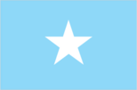
Flag description
- light blue with a large white five-pointed star in the center; the blue field was originally influenced by the flag of the UN, but today is said to denote the sky and the neighboring Indian Ocean; the five points of the star represent the five regions in the horn
- of Africa that are inhabited by Somali people
- the former British Somaliland and Italian Somaliland (which together make up Somalia), Djibouti, Ogaden (Ethiopia), and the Northern Frontier District (Kenya)
Government - note
although an interim government was created in 2004, other regional and local governing bodies continue to exist and control various regions of the country, including the self-declared Republic of Somaliland in northwestern Somalia and the semi-autonomous State of Puntland in northeastern Somalia
Government type
no permanent national government; transitional, parliamentary federal government
Independence
1 July 1960 (from a merger of British Somaliland that became independent from the UK on 26 June 1960 and Italian Somaliland that became independent from the Italian-administered UN trusteeship on 1 July 1960 to form the Somali Republic)
International organization participation
ACP, AfDB, AFESD, AMF, AU, CAEU, FAO, G-77, IBRD, ICAO, ICRM, IDA, IDB, IFAD, IFC, IFRCS, IGAD, ILO, IMF, IMO, Interpol, IOC, IOM, ITSO, ITU, LAS, NAM, OIC, UN, UNCTAD, UNESCO, UNHCR, UNIDO, UPU, WFTU, WHO, WIPO, WMO
Judicial branch
following the breakdown of the central government, most regions have reverted to local forms of conflict resolution, either secular, traditional Somali customary law, or sharia (Islamic) law with a provision for appeal of all sentences
Legal system
no national system; a mixture of English common law, Italian law, Islamic sharia, and Somali customary law; accepts compulsory ICJ jurisdiction with reservations
Legislative branch
unicameral National Assembly note: unicameral Transitional Federal Assembly (TFA) (550 seats; 475 members appointed according to the 4.5 clan formula, with the remaining 75 seats reserved for civil society and business persons)
National anthem
- lyrics/music
- Ali Mire AWALE and Yuusuf Xaaji Aadan Cilmi QABILLE note: adopted 2000; written in 1947, the lyrics speak of creating unity and an end to fighting
- name
- "Soomaaliyeey toosoo" (Somalia Wake Up)
National holiday
Foundation of the Somali Republic, 1 July (1960); note - 26 June (1960) in Somaliland
Political parties and leaders
none
Political pressure groups and leaders
- other
- numerous clan and sub-clan factions exist both in support and in opposition to the transitional government
Suffrage
18 years of age; universal
Economy
Agriculture - products
bananas, sorghum, corn, coconuts, rice, sugarcane, mangoes, sesame seeds, beans; cattle, sheep, goats; fish
Central bank discount rate
NA% (31 December 2008)
Commercial bank prime lending rate
NA%
Debt - external
$3 billion (2001 est.)
Economy - overview
Despite the lack of effective national governance, Somalia has maintained a healthy informal economy, largely based on livestock, remittance/money transfer companies, and telecommunications. Agriculture is the most important sector with livestock normally accounting for about 40% of GDP and more than 50% of export earnings. Nomads and semi-pastoralists, who are dependent upon livestock for their livelihood, make up a large portion of the population. Livestock, hides, fish, charcoal, and bananas are Somalia's principal exports, while sugar, sorghum, corn, qat, and machined goods are the principal imports. Somalia's small industrial sector, based on the processing of agricultural products, has largely been looted and the machinery sold as scrap metal. Somalia's service sector also has grown. Telecommunication firms provide wireless services in most major cities and offer the lowest international call rates on the continent. In the absence of a formal banking sector, money transfer/remittance services have sprouted throughout the country, handling up to $1.6 billion in remittances annually. Mogadishu's main market offers a variety of goods from food to the newest electronic gadgets. Hotels continue to operate and are supported with private-security militias. Due to armed attacks on and threats to humanitarian aid workers, the World Food Programme partially suspended its operations in southern Somalia in early January 2010 pending improvement in the security situation. Somalia's arrears to the IMF have continued to grow.
Electricity - consumption
260.4 million kWh (2007 est.)
Electricity - exports
0 kWh (2008 est.)
Electricity - imports
0 kWh (2008 est.)
Electricity - production
280 million kWh (2007 est.)
Exchange rates
Somali shillings (SOS) per US dollar - NA (2007-08), 1,438.3 (2006) official rate; the unofficial black market rate was about 23,000 shillings per dollar as of February 2007 note: the Republic of Somaliland, a self-declared independent country not recognized by any foreign government, issues its own currency, the Somaliland shilling
Exports
$300 million (2006)
Exports - commodities
livestock, bananas, hides, fish, charcoal, scrap metal
Exports - partners
UAE 58.27%, Yemen 20.32%, Saudi Arabia 3.78% (2009)
GDP - composition by sector
- agriculture
- 65%
- industry
- 10%
- services
- 25% (2005 est.)
GDP - per capita (PPP)
$600 (2010 est.) $600 (2009 est.) $600 (2008 est.) note: data are in 2010 US dollars
GDP - real growth rate
2.6% (2010 est.) 2.6% (2009 est.) 2.6% (2008 est.)
GDP (official exchange rate)
$2.372 billion (2010 est.)
GDP (purchasing power parity)
$5.896 billion (2010 est.) $5.75 billion (2009 est.) $5.607 billion (2008 est.) note: data are in 2010 US dollars
Household income or consumption by percentage share
lowest 10%: NA% highest 10%: NA%
Imports
$798 million (2006)
Imports - commodities
manufactures, petroleum products, foodstuffs, construction materials, qat
Imports - partners
Djibouti 30.84%, Kenya 8.06%, India 7.86%, China 6.97%, Brazil 6.59%, Yemen 4.97%, Oman 4.72%, UAE 4.6% (2009)
Industrial production growth rate
NA%
Industries
a few light industries, including sugar refining, textiles, wireless communication
Inflation rate (consumer prices)
NA% note: businesses print their own money, so inflation rates cannot be easily determined
Labor force
3.447 million (few skilled laborers) (2007)
Labor force - by occupation
- agriculture
- 71%
- industry and services
- 29% (1975)
Natural gas - consumption
0 cu m (2008 est.)
Natural gas - exports
0 cu m (2008 est.)
Natural gas - imports
0 cu m (2008 est.)
Natural gas - production
0 cu m (2008 est.)
Natural gas - proved reserves
5.663 billion cu m (1 January 2009 est.)
Oil - consumption
5,000 bbl/day (2009 est.)
Oil - exports
1,475 bbl/day (2007 est.)
Oil - imports
6,387 bbl/day (2007 est.)
Oil - production
108 bbl/day (2009 est.)
Oil - proved reserves
0 bbl (1 January 2010 est.)
Population below poverty line
NA%
Unemployment rate
NA%
Communications
Broadcast media
2 private TV stations rebroadcast Al-Jazeera and CNN; Somaliland has 1 government-operated TV station and Puntland has 1 private TV station; Radio Mogadishu operated by the transitional government; 1 SW and roughly 10 private FM radio stations broadcast in Mogadishu; several radio stations operate in central and southern regions; Somaliland has 1 government-operated radio station; Puntland has roughly a half dozen private radio stations; transmissions of at least 2 international broadcasters are available (2007)
Internet country code
.so
Internet hosts
3 (2010)
Internet users
106,000 (2009)
Telephone system
- domestic
- local cellular telephone systems have been established in Mogadishu and in several other population centers
- general assessment
- the public telecommunications system was almost completely destroyed or dismantled during the civil war; private companies offer limited local fixed-line service and private wireless companies offer service in most major cities while charging the lowest international rates on the continent
- international
- country code - 252; international connections are available from Mogadishu by satellite
Telephones - main lines in use
100,000 (2009)
Telephones - mobile cellular
641,000 (2009)
Transportation
Airports
59 (2010)
Airports - with paved runways
- total
- 7 over 3,047 m: 4 2,438 to 3,047 m: 2 1,524 to 2,437 m: 1 (2010)
Airports - with unpaved runways
- total
- 52 2,438 to 3,047 m: 4 1,524 to 2,437 m: 19 914 to 1,523 m: 23 under 914 m: 6 (2010)
Merchant marine
- by type
- cargo 1
- foreign-owned
- 1 (UAE 1) (2008)
- total
- 1
Ports and terminals
Berbera, Kismaayo
Roadways
- paved
- 2,608 km
- total
- 22,100 km
- unpaved
- 19,492 km (2000)
Transportation - note
the International Maritime Bureau reports the territorial and offshore waters in the Gulf of Aden and Indian Ocean are high risk for piracy and armed robbery against ships; numerous vessels, including commercial shipping and pleasure craft, have been attacked and hijacked both at anchor and while underway; crew, passengers, and cargo are held for ransom; the presence of several naval task forces in the Gulf of Aden and additional anti-piracy measures on the part of ship operators have reduced the piracy incidents; in response local pirates shifted operations farther south along the east coast of Somalia and eastward along the coast of Oman
Military and Security
Manpower available for military service
males age 16-49: 2,261,704 females age 16-49: 2,217,584 (2010 est.)
Manpower fit for military service
males age 16-49: 1,328,567 females age 16-49: 1,386,971 (2010 est.)
Manpower reaching militarily significant age annually
- female
- 99,771 (2010 est.)
- male
- 99,919
Military branches
- National Security Force (NSF)
- Somali Army (2010)
Military expenditures
0.9% of GDP (2005 est.)
Military service age and obligation
note: since 2005, the UN has listed the Transitional Federal Government and its allied militias as persistent violators in recruiting child soldiers (2010)
Transnational Issues
Disputes - international
Ethiopian forces invaded southern Somalia and routed Islamist Courts from Mogadishu in January 2007; "Somaliland" secessionists provide port facilities in Berbera to landlocked Ethiopia and have established commercial ties with other regional states; "Puntland" and "Somaliland" "governments" seek international support in their secessionist aspirations and overlapping border claims; the undemarcated former British administrative line has little meaning as a political separation to rival clans within Ethiopia's Ogaden and southern Somalia's Oromo region; Kenya works hard to prevent the clan and militia fighting in Somalia from spreading south across the border, which has long been open to nomadic pastoralists
Refugees and internally displaced persons
- IDPs
- 1.1 million (civil war since 1988, clan-based competition for resources) (2007) page last updated on January 19, 2011 ======================================================================