2010 Edition
CIA World Factbook 2010 (Project Gutenberg)
Introduction
Background
Democracy is slowly being reestablished after the civil war from 1991 to 2002 that resulted in tens of thousands of deaths and the displacement of more than 2 million people (about one-third of the population). The military, which took over full responsibility for security following the departure of UN peacekeepers at the end of 2005, is increasingly developing as a guarantor of the country's stability. The armed forces remained on the sideline during the 2007 presidential election, but still look to the UN Integrated Office in Sierra Leone (UNIOSIL) - a civilian UN mission - to support efforts to consolidate peace. The new government's priorities include furthering development, creating jobs, and stamping out endemic corruption.
Geography
Area
- land
- 71,620 sq km
- total
- 71,740 sq km
- water
- 120 sq km
Area - comparative
slightly smaller than South Carolina
Climate
tropical; hot, humid; summer rainy season (May to December); winter dry season (December to April)
Coastline
402 km
Elevation extremes
- highest point
- Loma Mansa (Bintimani) 1,948 m
- lowest point
- Atlantic Ocean 0 m
Environment - current issues
rapid population growth pressuring the environment; overharvesting of timber, expansion of cattle grazing, and slash-and-burn agriculture have resulted in deforestation and soil exhaustion; civil war depleted natural resources; overfishing
Environment - international agreements
- party to
- Biodiversity, Climate Change, Climate Change-Kyoto Protocol, Desertification, Endangered Species, Law of the Sea, Marine Life Conservation, Ozone Layer Protection, Ship Pollution, Wetlands signed, but not ratified: Environmental Modification
Freshwater withdrawal (domestic/industrial/agricultural)
- per capita
- 69 cu m/yr (2000)
- total
- 0.38 cu km/yr (5%/3%/92%)
Geographic coordinates
8 30 N, 11 30 W
Geography - note
rainfall along the coast can reach 495 cm (195 inches) a year, making it one of the wettest places along coastal, western Africa
Irrigated land
300 sq km (2003)
Land boundaries
- border countries
- Guinea 652 km, Liberia 306 km
- total
- 958 km
Land use
- arable land
- 7.95%
- other
- 91% (2005)
- permanent crops
- 1.05%
Location
Western Africa, bordering the North Atlantic Ocean, between Guinea and Liberia
Map references
Africa
Maritime claims
- contiguous zone
- 24 nm
- continental shelf
- 200 nm
- exclusive economic zone
- 200 nm
- territorial sea
- 12 nm
Natural hazards
dry, sand-laden harmattan winds blow from the Sahara (December to February); sandstorms, dust storms
Natural resources
diamonds, titanium ore, bauxite, iron ore, gold, chromite
Terrain
coastal belt of mangrove swamps, wooded hill country, upland plateau, mountains in east
Total renewable water resources
160 cu km (1987)
People and Society
Age structure
0-14 years: 41.7% (male 1,060,463/female 1,081,333) 15-64 years: 54.7% (male 1,344,650/female 1,461,203) 65 years and over: 3.6% (male 83,595/female 100,894) (2010 est.)
Birth rate
38.79 births/1,000 population (2010 est.)
Death rate
11.97 deaths/1,000 population (July 2010 est.)
Education expenditures
3.8% of GDP (2005)
Ethnic groups
Temne 35%, Mende 31%, Limba 8%, Kono 5%, Kriole 2% (descendants of freed Jamaican slaves who were settled in the Freetown area in the late-18th century; also known as Krio), Mandingo 2%, Loko 2%, other 15% (includes refugees from Liberia's recent civil war, and small numbers of Europeans, Lebanese, Pakistanis, and Indians) (2008 census)
HIV/AIDS - adult prevalence rate
1.7% (2007 est.)
HIV/AIDS - deaths
3,300 (2007 est.)
HIV/AIDS - people living with HIV/AIDS
55,000 (2007 est.)
Infant mortality rate
- female
- 70.99 deaths/1,000 live births (2010 est.)
- male
- 89.06 deaths/1,000 live births
- total
- 80.16 deaths/1,000 live births
Languages
English (official, regular use limited to literate minority), Mende (principal vernacular in the south), Temne (principal vernacular in the north), Krio (English-based Creole, spoken by the descendants of freed Jamaican slaves who were settled in the Freetown area, a lingua franca and a first language for 10% of the population but understood by 95%)
Life expectancy at birth
- female
- 58.18 years (2010 est.)
- male
- 53.27 years
- total population
- 55.69 years
Literacy
- definition: age 15 and over can read and write English, Mende, Temne, or Arabic
- female
- 24.4% (2004 est.)
- male
- 46.9%
- total population
- 35.1%
Major infectious diseases
- aerosolized dust or soil contact disease
- Lassa fever (2009)
- degree of risk
- very high
- food or waterborne diseases
- bacterial and protozoal diarrhea, hepatitis A, and typhoid fever
- vectorborne diseases
- malaria and yellow fever
- water contact disease
- schistosomiasis
Median age
- female
- 19.5 years (2010 est.)
- male
- 18.6 years
- total
- 19 years
Nationality
- adjective
- Sierra Leonean
- noun
- Sierra Leonean(s)
Net migration rate
-4.66 migrant(s)/1,000 population note: refugees currently in surrounding countries are slowly returning (2010 est.)
Population
5,245,695 (July 2010 est.)
Population growth rate
2.216% (2010 est.)
Religions
Muslim 60%, Christian 10%, indigenous beliefs 30%
School life expectancy (primary to tertiary education)
- female
- 6 years (2001)
- male
- 9 years
- total
- 7 years
Sex ratio
- at birth
- 1.03 male(s)/female under 15 years: 0.98 male(s)/female 15-64 years: 0.92 male(s)/female 65 years and over: 0.81 male(s)/female
- total population
- 0.94 male(s)/female (2010 est.)
Total fertility rate
4.97 children born/woman (2010 est.)
Urbanization
- rate of urbanization
- 2.9% annual rate of change (2005-10 est.)
- urban population
- 38% of total population (2008)
Government
Administrative divisions
3 provinces and 1 area*; Eastern, Northern, Southern, Western*
Capital
- geographic coordinates
- 8 30 N, 13 15 W
- name
- Freetown
- time difference
- UTC 0 (5 hours ahead of Washington, DC during Standard Time)
Constitution
1 October 1991; amended several times
Country name
- conventional long form
- Republic of Sierra Leone
- conventional short form
- Sierra Leone
- local long form
- Republic of Sierra Leone
- local short form
- Sierra Leone
Diplomatic representation from the US
- chief of mission
- Ambassador (vacant); Charge d'Affaires Glenn FEDZER
- embassy
- Southridge-Hill Station, Freetown
- FAX
- [232] (22) 515 355
- mailing address
- use embassy street address
- telephone
- [232] (22) 515 000 or (76) 515 000
Diplomatic representation in the US
- chancery
- 1701 19th Street NW, Washington, DC 20009
- chief of mission
- Ambassador Bockari Kortu STEVENS
- FAX
- [1] (202) 483-1793
- telephone
- [1] (202) 939-9261 through 9263
Executive branch
- cabinet
- Ministers of State appointed by the president with the approval of the House of Representatives; the cabinet is responsible to the president (For more information visit the World Leaders website )
- chief of state
- President Ernest Bai KOROMA (since 17 September 2007); note - the president is both the chief of state and head of government
- election results
- second round results; percent of vote - Ernest Bai KOROMA 54.6%, Solomon BEREWA 45.4%
- elections
- president elected by popular vote for a five-year term (eligible for a second term); election last held on 11 August 2007 and 8 September 2007 (next to be held in 2012)
- head of government
- President Ernest Bai KOROMA (since 17 September 2007)
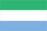
Flag description
three equal horizontal bands of green (top), white, and blue; green symbolizes agriculture, mountains, and natural resources, white represents unity and justice, and blue the sea and the natural harbor in Freetown
Government type
constitutional democracy
Independence
27 April 1961 (from the UK)
International organization participation
ACP, AfDB, AU, C, ECOWAS, FAO, G-77, IAEA, IBRD, ICAO, ICCt, ICRM, IDA, IDB, IFAD, IFC, IFRCS, ILO, IMF, IMO, Interpol, IOC, IOM, IPU, ISO (correspondent), ITU, ITUC, MIGA, NAM, OIC, OPCW, UN, UNAMID, UNCTAD, UNESCO, UNIDO, UNIFIL, UNMIS, UNMIT, UNWTO, UPU, WCO, WFTU, WHO, WIPO, WMO, WTO
Judicial branch
Supreme Court; Appeals Court; High Court
Legal system
based on English law and customary laws indigenous to local tribes; has not accepted compulsory ICJ jurisdiction
Legislative branch
- unicameral Parliament (124 seats; 112 members elected by popular vote, 12 filled by paramount chiefs elected in separate elections; members to serve five-year terms)
- election results
- percent of vote by party - NA; seats by party - APC 59, SLPP 43, PMDC 10
- elections
- last held on 11 August 2007 (next to be held in 2012)
National anthem
- lyrics/music
- Clifford Nelson FYLE/John Joseph AKA note: adopted 1961
- name
- "High We Exalt Thee, Realm of the Free"
National holiday
Independence Day, 27 April (1961)
Political parties and leaders
All People's Congress or APC [Ernest Bai KOROMA]; Peace and Liberation Party or PLP [Darlington MORRISON]; People's Movement for Democratic Change or PMDC [Charles MARGAI]; Sierra Leone People's Party or SLPP [Solomon BEREWA]; numerous others
Political pressure groups and leaders
- other
- student unions; trade unions
Suffrage
18 years of age; universal
Economy
Agriculture - products
rice, coffee, cocoa, palm kernels, palm oil, peanuts; poultry, cattle, sheep, pigs; fish
Central bank discount rate
NA%
Commercial bank prime lending rate
NA% (31 December 2009 est.) 24.5% (31 December 2008 est.)
Current account balance
-$63 million (2007 est.)
Debt - external
$1.61 billion (2003 est.)
Distribution of family income - Gini index
62.9 (1989)
Economy - overview
Sierra Leone is an extremely poor nation with tremendous inequality in income distribution. While it possesses substantial mineral, agricultural, and fishery resources, its physical and social infrastructure has yet to recover from the civil war, and serious social disorders continue to hamper economic development. Nearly half of the working-age population engages in subsistence agriculture. Manufacturing consists mainly of the processing of raw materials and of light manufacturing for the domestic market. Alluvial diamond mining remains the major source of hard currency earnings accounting for nearly half of Sierra Leone's exports. The fate of the economy depends upon the maintenance of domestic peace and the continued receipt of substantial aid from abroad, which is essential to offset the severe trade imbalance and supplement government revenues. The IMF has completed a Poverty Reduction and Growth Facility program that helped stabilize economic growth and reduce inflation and in 2010 approved a new program worth $45 million over three years. Political stability has led to a revival of economic activity such as the rehabilitation of bauxite and rutile mining, which are set to benefit from planned tax incentives. A number of offshore oil discoveries were announced in 2009 and 2010. The development on these reserves, which could be significant, is still several years away.
Electricity - consumption
74.4 million kWh (2007 est.)
Electricity - exports
0 kWh (2008 est.)
Electricity - imports
0 kWh (2008 est.)
Electricity - production
80 million kWh (2007 est.)
Exchange rates
leones (SLL) per US dollar - NA (2007), 2,961.7 (2006), 2,889.6 (2005), 2,701.3 (2004), 2,347.9 (2003)
Exports
$216 million (2006)
Exports - commodities
diamonds, rutile, cocoa, coffee, fish
Exports - partners
Belgium 26.56%, US 11.87%, Netherlands 7.91%, UK 7.4%, India 6.67%, Cote d'Ivoire 6.13%, Greece 4.05% (2009)
GDP - composition by sector
- agriculture
- 49%
- industry
- 31%
- services
- 21% (2005 est.)
GDP - per capita (PPP)
$900 (2010 est.) $900 (2009 est.) $900 (2008 est.) note: data are in 2010 US dollars
GDP - real growth rate
5.2% (2010 est.) 4.4% (2009 est.) 5.5% (2008 est.)
GDP (official exchange rate)
$1.901 billion (2010 est.)
GDP (purchasing power parity)
$4.812 billion (2010 est.) $4.574 billion (2009 est.) $4.382 billion (2008 est.) note: data are in 2010 US dollars
Household income or consumption by percentage share
lowest 10%: 2.6% highest 10%: 33.6% (2003)
Imports
$560 million (2006)
Imports - commodities
foodstuffs, machinery and equipment, fuels and lubricants, chemicals
Imports - partners
South Africa 14.61%, China 7.58%, US 5.87%, Cote d'Ivoire 5.65%, India 5.19%, Malaysia 5.19%, France 5.08%, UK 4.48%, Netherlands 4.06% (2009)
Industrial production growth rate
NA%
Industries
diamond mining; small-scale manufacturing (beverages, textiles, cigarettes, footwear); petroleum refining, small commercial ship repair
Inflation rate (consumer prices)
11.7% (2007 est.)
Labor force
2.207 million (2007 est.)
Labor force - by occupation
- agriculture
- NA%
- industry
- NA%
- services
- NA%
Market value of publicly traded shares
$NA
Natural gas - consumption
0 cu m (2008 est.)
Natural gas - exports
0 cu m (2008 est.)
Natural gas - imports
0 cu m (2008 est.)
Natural gas - production
0 cu m (2008 est.)
Natural gas - proved reserves
0 cu m (1 January 2010 est.)
Oil - consumption
9,000 bbl/day (2009 est.)
Oil - exports
502 bbl/day (2007 est.)
Oil - imports
8,316 bbl/day (2007 est.)
Oil - production
29 bbl/day (2009 est.)
Oil - proved reserves
0 bbl (1 January 2010 est.)
Population below poverty line
70.2% (2004)
Stock of broad money
$437 million (31 December 2009) $434.3 million (31 December 2008)
Stock of domestic credit
$178.4 million (31 December 2009) $140.9 million (31 December 2008)
Stock of narrow money
$209.4 million (31 December 2009) $219.1 million (31 December 2008)
Unemployment rate
NA%
Communications
Broadcast media
1 government-owned TV station; 1 private TV station began operating in 2005; a pay-per-view TV service began operations in late 2007; 1 government-owned national radio broadcast station; about two dozen private radio stations primarily clustered in major cities; transmissions of several international broadcasters are available (2007)
Internet country code
.sl
Internet hosts
281 (2010)
Internet users
14,900 (2009)
Telephone system
- domestic
- the national microwave radio relay trunk system connects Freetown to Bo and Kenema; while mobile-cellular service is growing rapidly from a small base, service area coverage remains limited
- general assessment
- marginal telephone service with poor infrastructure
- international
- country code - 232; satellite earth station - 1 Intelsat (Atlantic Ocean) (2008)
Telephones - main lines in use
32,800 (2009)
Telephones - mobile cellular
1.16 million (2009)
Transportation
Airports
9 (2010)
Airports - with paved runways
- total
- 1 over 3,047 m: 1 (2010)
Airports - with unpaved runways
- total
- 8 914 to 1,523 m: 7 under 914 m: 1 (2010)
Heliports
2 (2010)
Merchant marine
- by type
- bulk carrier 7, cargo 131, carrier 1, chemical tanker 12, container 3, liquefied gas 3, passenger 1, passenger/cargo 6, petroleum tanker 20, refrigerated cargo 1, roll on/roll off 3, vehicle carrier 1
- foreign-owned
- 91 (Bangladesh 1, China 12, Cyprus 1, Egypt 2, Estonia 1, Hong Kong 4, Japan 3, Malaysia 1, North Korea 1, Romania 4, Russia 6, Singapore 5, Syria 20, Taiwan 1, Turkey 14, UAE 6, UK 1, Ukraine 5, US 1, Yemen 2) (2010)
- total
- 189
Ports and terminals
Freetown, Pepel, Sherbro Islands
Roadways
- paved
- 904 km
- total
- 11,300 km
- unpaved
- 10,396 km (2002)
Waterways
800 km (600 km year round) (2007)
Military and Security
Manpower available for military service
males age 16-49: 1,156,724 (2010 est.)
Manpower fit for military service
males age 16-49: 713,190 females age 16-49: 813,830 (2010 est.)
Manpower reaching militarily significant age annually
- female
- 56,307 (2010 est.)
- male
- 53,349
Military branches
- Republic of Sierra Leone Armed Forces (RSLAF)
- Army (includes Maritime Wing and Air Wing) (2010)
Military expenditures
2.3% of GDP (2006)
Military service age and obligation
17 years 6 months of age for male and female voluntary military service (younger with parental consent); no conscription; candidates must be HIV negative (2009)
Transnational Issues
Disputes - international
as domestic fighting among disparate ethnic groups, rebel groups, warlords, and youth gangs in Cote d'Ivoire, Guinea, Liberia, and Sierra Leone gradually abates, the number of refugees in border areas has begun to slowly dwindle; Sierra Leone considers excessive Guinea's definition of the flood plain limits to define the left bank boundary of the Makona and Moa rivers and protests Guinea's continued occupation of these lands including the hamlet of Yenga occupied since 1998
Refugees and internally displaced persons
- refugees (country of origin)
- 27,311 (Liberia) (2007) page last updated on January 11, 2011 ======================================================================