1996 Edition
CIA World Factbook 1996 (Project Gutenberg)
Introduction
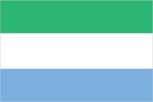
Description
three equal horizontal bands of light green (top), white, and light blue
Location
8 30 N, 11 30 W -- Western Africa, bordering the North Atlantic Ocean, between Guinea and Liberia Flag ----
Geography
Area
- comparative area
- slightly smaller than South Carolina
- land area
- 71,620 sq km
- total area
- 71,740 sq km
Climate
tropical; hot, humid; summer rainy season (May to December); winter dry season (December to April)
Coastline
402 km
Environment
- current issues
- rapid population growth pressuring the environment; overharvesting of timber, expansion of cattle grazing, and slash-and-burn agriculture have resulted in deforestation and soil exhaustion; civil war depleting natural resources; overfishing
- international agreements
- party to - Biodiversity, Climate Change, Endangered Species, Law of the Sea, Marine Life Conservation, Nuclear Test Ban, Whaling; signed, but not ratified - Desertification, Environmental Modification
- natural hazards
- dry, sand-laden harmattan winds blow from the Sahara (November to May); sandstorms, dust storms
Geographic coordinates
8 30 N, 11 30 W
International disputes
none
Irrigated land
340 sq km (1989 est.)
Land boundaries
- border countries
- Guinea 652 km, Liberia 306 km
- total
- 958 km
Land use
- arable land
- 25%
- forest and woodland
- 29%
- meadows and pastures
- 31%
- other
- 13%
- permanent crops
- 2%
Location
Western Africa, bordering the North Atlantic Ocean, between Guinea and Liberia
Map references
Africa
Maritime claims
- continental shelf
- 200-m depth or to the depth of exploitation
- territorial sea
- 200 nm
Natural resources
diamonds, titanium ore, bauxite, iron ore, gold, chromite
Terrain
- coastal belt of mangrove swamps, wooded hill country, upland plateau, mountains in east
- highest point
- Loma Mansa (Bintimani) 1,948 m
- lowest point
- Atlantic Ocean 0 m
People and Society
Age structure
0-14 years: 45% (male 1,057,824; female 1,092,291) 15-64 years: 52% (male 1,197,547; female 1,298,834) 65 years and over: 3% (male 75,066; female 71,559) (July 1996 est.)
Birth rate
47.13 births/1,000 population (1996 est.)
Death rate
18.24 deaths/1,000 population (1996 est.)
Ethnic divisions
13 native African tribes 99% (Temne 30%, Mende 30%, other 39%), Creole, European, Lebanese, and Asian 1%
Infant mortality rate
135.6 deaths/1,000 live births (1996 est.)
Languages
English (official, regular use limited to literate minority), Mende (principal vernacular in the south), Temne (principal vernacular in the north), Krio (the language of the re-settled ex-slave population of the Freetown area and is lingua franca)
Life expectancy at birth
- female
- 50.47 years (1996 est.)
- male
- 44.56 years
- total population
- 47.47 years
Literacy
- age 15 and over can read and write in English, Mende, Temne, or Arabic (1995 est.)
- female
- 18.2%
- male
- 45.4%
- total population
- 31.4%
Nationality
- adjective
- Sierra Leonean
- noun
- Sierra Leonean(s)
Net migration rate
12.52 migrant(s)/1,000 population (1996 est.)
Population
4,793,121 (July 1996 est.)
Population growth rate
4.14% (1996 est.)
Religions
Muslim 60%, indigenous beliefs 30%, Christian 10%
Sex ratio
- all ages
- 0.95 male(s)/female (1996 est.)
- at birth
- 1.03 male(s)/female
- under 15 years
- 0.97 male(s)/female 15-64 years: 0.92 male(s)/female 65 years and over: 1.05 male(s)/female
Total fertility rate
6.36 children born/woman (1996 est.)
Government
Administrative divisions
3 provinces and 1 area*; Eastern, Northern, Southern, Western*
Capital
Freetown
Constitution
1 October 1991; subsequently amended several times
Data code
SL
Diplomatic representation in US
- chancery
- 1701 19th Street NW, Washington, DC 20009
- chief of mission
- (vacant)
- telephone
- [1] (202) 939-9261
Executive branch
- cabinet
- Ministers of State appointed by the president with the approval of the House of Representatives; the cabinet is responsible to the president
- chief of state and head of government
- President Ahmad Tejan KABBAH (inaugurated 29 March 1996); election held 26-27 February 1996 (next to be held NA 2000)
FAX
[232] (22) 225471
Flag
three equal horizontal bands of light green (top), white, and light blue
House of Representatives
elections last held NA February 1996 (next to be held NA); results - percent of vote by party NA; seats (80 total, 68 elected, 12 filled by paramount chiefs elected in separate elections) SLPP 27, UNPP 17, PDP 12, APC 5, NUP 4, DCP 3; note - first elections since the former House of Representatives was shut down by the military coup of 29 April 1992
Independence
27 April 1961 (from UK)
International organization participation
ACP, AfDB, C, CCC, ECA, ECOWAS, FAO, G-77, IAEA, IBRD, ICAO, ICFTU, ICRM, IDA, IDB, IFAD, IFC, IFRCS, ILO, IMF, IMO, Intelsat (nonsignatory user), Interpol, IOC, ITU, NAM, OAU, OIC, UN, UNCTAD, UNESCO, UNIDO, UPU, WCL, WFTU, WHO, WIPO, WMO, WToO, WTrO
Judicial branch
Supreme Court
Legal system
based on English law and customary laws indigenous to local tribes; has not accepted compulsory ICJ jurisdiction
Legislative branch
unicameral
Name of country
- conventional long form
- Republic of Sierra Leone
- conventional short form
- Sierra Leone
National holiday
Republic Day, 27 April (1961)
Political parties and leaders
15 parties registered for the February 1996 elections; National Peoples Party (NPP), Andrew TURAY; Democratic Center Party (DCP), Abu KOROMA; Peoples Progressive Party (PPP), Edward KAMARA, chairman; Coalition for Progress Party (CPP), Geredine WILLIAMS-SARHO; National Unity Movement (NUM); United National Peoples Party (UNPP); Peoples Democratic Party (PDP), Thaimu BANGURA, chairman; All Peoples Congress (APC), S. A. T. KOROMA, chairman; National Republican Party (NRP); Social Democratic Party (SDP); Peoples National Convention (PNC), I. B. KARGBO, chairman; National Unity Party (NUP), A. O. D. GEORGE, chairman; Sierra Leone Peoples Party (SLPP), Paul DUNBAR, chairman; National Democratic Alliance (NDA); National Alliance for Democracy Party (NADP)
Suffrage
18 years of age; universal
Type of government
constitutional democracy
US diplomatic representation
- chief of mission
- Ambassador John L. HIRSCH
- embassy
- Corner of Walpole and Siaka Stevens Streets, Freetown
- mailing address
- use embassy street address
- telephone
- [232] (22) 226481 through 226485
Economy
Agriculture
rice, coffee, cocoa, palm kernels, palm oil, peanuts; poultry, cattle, sheep, pigs; fish catch was 65,000 metric tons in 1994
Budget
- expenditures
- $128 million, including capital expenditures of $NA (FY94/95 est.)
- revenues
- $75 million
Currency
1 leone (Le) = 100 cents
Economic aid
- recipient
- ODA, $NA
Economic overview
Sierra Leone has substantial mineral, agricultural, and fishery resources. However, the economic and social infrastructure is not well developed, and serious social disorders continue to push down production, exports, and the value of the leone. Agriculture employs about two-thirds of the working population, with subsistence agriculture dominating the sector. Manufacturing consists mainly of the processing of raw materials and of light manufacturing for the domestic market. The mining of diamonds, bauxite, and rutile is the major source of hard currency. The government has worked hard to meet its IMF- and World Bank-mandated stabilization targets, holding down fiscal deficits, and retiring much of its domestic debt - but at a steep cost in terms of forgone capital investments and social spending. Moreover, the economic infrastructure has nearly collapsed due to neglect and war-related disruptions in the mining and agricultural export sectors. The continuing civil war in Liberia has led to a large influx of refugees, who place additional burdens on Sierra Leone's fragile economy.
Electricity
- capacity
- 130,000 kW
- consumption per capita
- 44 kWh (1993)
- production
- 220 million kWh
Exchange rates
leones (Le) per US$1 - 951.63 (January 1996), 755.22 (1995), 586.74 (1994), 567.46 (1993), 499.44 (1992), 295.34 (1991)
Exports
- $115 million (f.o.b., 1994)
- commodities
- rutile 51%, bauxite 20%, diamonds 16%, coffee 6%, cocoa 7%, fish (1989)
- partners
- US, UK, Belgium, Germany, other Western Europe
External debt
$1.4 billion (yearend 1993)
Fiscal year
1 July - 30 June
GDP
purchasing power parity - $4.4 billion (1994 est.)
GDP composition by sector
- agriculture
- 40%
- industry
- 17%
- services
- 43% (1994)
GDP per capita
$960 (1994 est.)
GDP real growth rate
-4% (1994 est.)
Imports
- $150 million (c.i.f., 1994)
- commodities
- foodstuffs 38%, machinery and equipment 44%, fuels and lubricants 18% (1989)
- partners
- US, EU countries, Japan, China, Nigeria
Industrial production growth rate
$NA
Industries
mining (diamonds, bauxite, rutile); small-scale manufacturing (beverages, textiles, cigarettes, footwear); petroleum refining
Inflation rate (consumer prices)
24% (1994 est.)
Labor force
- 1.369 million (1981 est.)
- by occupation
- agriculture 65%, industry 19%, services 16% (1981 est.)
- note
- only about 65,000 wage earners (1985)
Unemployment rate
NA%
Communications
Branches
Army, Navy, Police, Security Forces
Defense expenditures
exchange rate conversion - $14 million, 2.6% of GDP (FY92/93)
Manpower availability
- males age 15-49
- 1,019,093
- males fit for military service
- 494,451 (1996 est.)
Radio broadcast stations
AM 1, FM 1, shortwave 0
Radios
980,000 (1992 est.)
Telephone system
- marginal telephone and telegraph service
- domestic
- national microwave radio relay system made unserviceable by military activities
- international
- satellite earth station - 1 Intelsat (Atlantic Ocean)
Telephones
17,526 (1991 est.)
Television broadcast stations
1
Televisions
45,000 (1992 est.) Defense
Transportation
Airports
- total
- 5
- with paved runways 914 to 1 523 m
- 2
- with paved runways over 3 047 m
- 1
- with unpaved runways 914 to 1 523 m
- 2 (1995 est.)
Highways
- paved
- 1,284 km
- total
- 11,674 km
- unpaved
- 10,390 km (1992 est.)
Merchant marine
none
Ports
Bonthe, Freetown, Pepel
Railways
- narrow gauge
- 84 km 1.067-m gauge
- total
- 84 km used on a limited basis because the mine at Marampa is closed
Waterways
800 km; 600 km navigable year round