2016 Edition
CIA World Factbook 2016 Archive (HTML)
Introduction
Background
The French colonies of Senegal and French Sudan were merged in 1959 and granted independence in 1960 as the Mali Federation. The union broke up after only a few months. Senegal joined with The Gambia to form the nominal confederation of Senegambia in 1982. The envisaged integration of the two countries was never implemented, and the union was dissolved in 1989. The Movement of Democratic Forces in the Casamance has led a low-level separatist insurgency in southern Senegal since the 1980s, and several peace deals have failed to resolve the conflict. Nevertheless, Senegal remains one of the most stable democracies in Africa and has a long history of participating in international peacekeeping and regional mediation. Senegal was ruled by a Socialist Party for 40 years until Abdoulaye WADE was elected president in 2000. He was reelected in 2007 and during his two terms amended Senegal's constitution over a dozen times to increase executive power and weaken the opposition. His decision to run for a third presidential term sparked a large public backlash that led to his defeat in a March 2012 runoff with Macky SALL, whose term runs until 2019. A 2016 constitutional referendum reduced the term to five years with a maximum of two consecutive terms for future presidents.
Geography
Area
- 196,722 sq km 192,530 sq km 4,192 sq km
- land
- 192,530 sq km
- total
- 196,722 sq km
- water
- 4,192 sq km
Area - comparative
slightly smaller than South Dakota
Climate
tropical; hot, humid; rainy season (May to November) has strong southeast winds; dry season (December to April) dominated by hot, dry, harmattan wind
Coastline
531 km
Elevation
- 69 m lowest point: Atlantic Ocean 0 m highest point: unnamed elevation southwest of Kedougou 581 m
- elevation extremes
- lowest point: Atlantic Ocean 0 m
- highest point
- unnamed elevation southwest of Kedougou 581 m
- mean elevation
- 69 m
Environment - current issues
wildlife populations threatened by poaching; deforestation; overgrazing; soil erosion; desertification; overfishing
Environment - international agreements
- Biodiversity, Climate Change, Climate Change-Kyoto Protocol, Desertification, Endangered Species, Hazardous Wastes, Law of the Sea, Marine Life Conservation, Ozone Layer Protection, Ship Pollution, Wetlands, Whaling none of the selected agreements
- party to
- Biodiversity, Climate Change, Climate Change-Kyoto Protocol, Desertification, Endangered Species, Hazardous Wastes, Law of the Sea, Marine Life Conservation, Ozone Layer Protection, Ship Pollution, Wetlands, Whaling
- signed, but not ratified
- none of the selected agreements
Geographic coordinates
14 00 N, 14 00 W
Geography - note
westernmost country on the African continent; The Gambia is almost an enclave within Senegal
Irrigated land
1,200 sq km (2012)
Land boundaries
- 2,684 km The Gambia 749 km, Guinea 363 km, Guinea-Bissau 341 km, Mali 489 km, Mauritania 742 km
- border countries (5)
- The Gambia 749 km, Guinea 363 km, Guinea-Bissau 341 km, Mali 489 km, Mauritania 742 km
- total
- 2,684 km
Land use
- 46.8% arable land 17.4%; permanent crops 0.3%; permanent pasture 29.1% 43.8% 9.4% (2011 est.)
- agricultural land
- 46.8%
- forest
- 43.8%
- other
- 9.4% (2011 est.)
Location
Western Africa, bordering the North Atlantic Ocean, between Guinea-Bissau and Mauritania
Map references
Africa
Maritime claims
- 12 nm 24 nm 200 nm 200 nm or to the edge of the continental margin
- contiguous zone
- 24 nm
- continental shelf
- 200 nm or to the edge of the continental margin
- exclusive economic zone
- 200 nm
- territorial sea
- 12 nm
Natural hazards
lowlands seasonally flooded; periodic droughts
Natural resources
fish, phosphates, iron ore
Terrain
generally low, rolling, plains rising to foothills in southeast
People and Society
Age structure
- 41.85% (male 3,011,233/female 2,981,128) 20.36% (male 1,452,415/female 1,462,989) 30.93% (male 2,031,035/female 2,398,788) 3.91% (male 242,429/female 317,439) 2.95% (male 189,201/female 233,398) (2016 est.)
- 0-14 years
- 41.85% (male 3,011,233/female 2,981,128)
- 15-24 years
- 20.36% (male 1,452,415/female 1,462,989)
- 25-54 years
- 30.93% (male 2,031,035/female 2,398,788)
- 55-64 years
- 3.91% (male 242,429/female 317,439)
- 65 years and over
- 2.95% (male 189,201/female 233,398) (2016 est.)
Birth rate
34 births/1,000 population (2016 est.)
Child labor - children ages 5-14
- 657,216 22% (2005 est.)
- percentage
- 22% (2005 est.)
- total number
- 657,216
Children under the age of 5 years underweight
12.8% (2014)
Contraceptive prevalence rate
17.8% (2012/13)
Death rate
8.3 deaths/1,000 population (2016 est.)
Demographic profile
Senegal has a large and growing youth population but has not been successful in developing its potential human capital. Senegal’s high total fertility rate of almost 4.5 children per woman continues to bolster the country’s large youth cohort – more than 60% of the population is under the age of 25. Fertility remains high because of the continued desire for large families, the low use of family planning, and early childbearing. Because of the country’s high illiteracy rate (more than 40%), high unemployment (even among university graduates), and widespread poverty, Senegalese youths face dim prospects; women are especially disadvantaged. Senegal historically was a destination country for economic migrants, but in recent years West African migrants more often use Senegal as a transit point to North Africa – and sometimes illegally onward to Europe. The country also has been host to several thousand black Mauritanian refugees since they were expelled from their homeland during its 1989 border conflict with Senegal. The country’s economic crisis in the 1970s stimulated emigration; departures accelerated in the 1990s. Destinations shifted from neighboring countries, which were experiencing economic decline, civil wars, and increasing xenophobia, to Libya and Mauritania because of their booming oil industries and to developed countries (most notably former colonial ruler France, as well as Italy and Spain). The latter became attractive in the 1990s because of job opportunities and their periodic regularization programs (legalizing the status of illegal migrants). Additionally, about 16,000 Senegalese refugees still remain in The Gambia and Guinea-Bissau as a result of more than 30 years of fighting between government forces and rebel separatists in southern Senegal’s Casamance region.
Dependency ratios
- 87.6% 82.1% 5.5% 18.2% (2015 est.)
- elderly dependency ratio
- 5.5%
- potential support ratio
- 18.2% (2015 est.)
- total dependency ratio
- 87.6%
- youth dependency ratio
- 82.1%
Drinking water source
- urban: 92.9% of population rural: 67.3% of population total: 78.5% of population urban: 7.1% of population rural: 32.7% of population total: 21.5% of population (2015 est.)
- rural
- 32.7% of population
- total
- 21.5% of population (2015 est.)
- urban
- 7.1% of population
Education expenditures
5.6% of GDP (2010)
Ethnic groups
Wolof 38.7%, Pular 26.5%, Serer 15%, Mandinka 4.2%, Jola 4%, Soninke 2.3%, other 9.3% (includes Europeans and persons of Lebanese descent) (2010-11 est.)
Health expenditures
4.7% of GDP (2014)
HIV/AIDS - adult prevalence rate
0.52% (2015 est.)
HIV/AIDS - deaths
2,200 (2015 est.)
HIV/AIDS - people living with HIV/AIDS
45,800 (2015 est.)
Hospital bed density
0.3 beds/1,000 population (2008)
Infant mortality rate
- 50.3 deaths/1,000 live births 56.3 deaths/1,000 live births 44.2 deaths/1,000 live births (2016 est.)
- female
- 44.2 deaths/1,000 live births (2016 est.)
- male
- 56.3 deaths/1,000 live births
- total
- 50.3 deaths/1,000 live births
Languages
French (official), Wolof, Pulaar, Jola, Mandinka
Life expectancy at birth
- 61.7 years 59.7 years 63.8 years (2016 est.)
- female
- 63.8 years (2016 est.)
- male
- 59.7 years
- total population
- 61.7 years
Literacy
- age 15 and over can read and write 57.7% 69.7% 46.6% (2015 est.)
- definition
- age 15 and over can read and write
- female
- 46.6% (2015 est.)
- male
- 69.7%
- total population
- 57.7%
Major infectious diseases
- very high bacterial and protozoal diarrhea, hepatitis A, and typhoid fever malaria and dengue fever schistosomiasis meningococcal meningitis rabies (2016)
- animal contact disease
- rabies (2016)
- degree of risk
- very high
- food or waterborne diseases
- bacterial and protozoal diarrhea, hepatitis A, and typhoid fever
- respiratory disease
- meningococcal meningitis
- vectorborne diseases
- malaria and dengue fever
- water contact disease
- schistosomiasis
Major urban areas - population
DAKAR (capital) 3.52 million (2015)
Maternal mortality rate
315 deaths/100,000 live births (2015 est.)
Median age
- 18.7 years 17.8 years 19.6 years (2016 est.)
- female
- 19.6 years (2016 est.)
- male
- 17.8 years
- total
- 18.7 years
Mother's mean age at first birth
- 21.4 median age at first birth among women 25-29 (2014 est.)
- note
- median age at first birth among women 25-29 (2014 est.)
Nationality
- Senegalese (singular and plural) Senegalese
- adjective
- Senegalese
- noun
- Senegalese (singular and plural)
Net migration rate
-1.5 migrant(s)/1,000 population (2016 est.)
Obesity - adult prevalence rate
8.3% (2014)
Physicians density
0.06 physicians/1,000 population (2008)
Population
14,320,055 (July 2016 est.)
Population growth rate
2.42% (2016 est.)
Religions
Muslim 95.4% (most adhere to one of the four main Sufi brotherhoods), Christian 4.2% (mostly Roman Catholic), animist 0.4% (2010-11 est.)
Sanitation facility access
- urban: 65.4% of population rural: 33.8% of population total: 47.6% of population urban: 34.6% of population rural: 66.2% of population total: 52.4% of population (2015 est.)
- rural
- 66.2% of population
- total
- 52.4% of population (2015 est.)
- urban
- 34.6% of population
School life expectancy (primary to tertiary education)
- 8 years 8 years 8 years (2010)
- female
- 8 years (2010)
- male
- 8 years
- total
- 8 years
Sex ratio
- 1.03 male(s)/female 1.01 male(s)/female 0.99 male(s)/female 0.85 male(s)/female 0.76 male(s)/female 0.82 male(s)/female 0.94 male(s)/female (2016 est.)
- 0-14 years
- 1.01 male(s)/female
- 15-24 years
- 0.99 male(s)/female
- 25-54 years
- 0.85 male(s)/female
- 55-64 years
- 0.76 male(s)/female
- 65 years and over
- 0.82 male(s)/female
- at birth
- 1.03 male(s)/female
- total population
- 0.94 male(s)/female (2016 est.)
Total fertility rate
4.36 children born/woman (2016 est.)
Unemployment, youth ages 15-24
- 12.7% 8.3% 19% (2011 est.)
- female
- 19% (2011 est.)
- male
- 8.3%
- total
- 12.7%
Urbanization
- 43.7% of total population (2015) 3.59% annual rate of change (2010-15 est.)
- rate of urbanization
- 3.59% annual rate of change (2010-15 est.)
- urban population
- 43.7% of total population (2015)
Government
Administrative divisions
14 regions (regions, singular - region); Dakar, Diourbel, Fatick, Kaffrine, Kaolack, Kedougou, Kolda, Louga, Matam, Saint-Louis, Sedhiou, Tambacounda, Thies, Ziguinchor
Capital
- Dakar 14 44 N, 17 38 W UTC 0 (5 hours ahead of Washington, DC, during Standard Time)
- geographic coordinates
- 14 44 N, 17 38 W
- name
- Dakar
- time difference
- UTC 0 (5 hours ahead of Washington, DC, during Standard Time)
Citizenship
- no at least one parent must be a citizen of Senegal no, but Senegalese citizens do not automatically lose their citizenship if they acquire citizenship in another state 5 years
- citizenship by birth
- no
- citizenship by descent only
- at least one parent must be a citizen of Senegal
- dual citizenship recognized
- no, but Senegalese citizens do not automatically lose their citizenship if they acquire citizenship in another state
- residency requirement for naturalization
- 5 years
Constitution
previous 1959 (preindependence), 1963; latest adopted by referendum 7 January 2001, promulgated 22 January 2001; amended many times, last in 2016 (2016)
Country name
- Republic of Senegal Senegal Republique du Senegal Senegal Senegambia (along with The Gambia), Mali Federation named for the Senegal River that forms the northern border of the country; many theories exist for the origin of the river name; perhaps the most widely cited derives the name from "Azenegue," the Portuguese appellation for the Berber Zenaga people who lived north of the river
- conventional long form
- Republic of Senegal
- conventional short form
- Senegal
- etymology
- named for the Senegal River that forms the northern border of the country; many theories exist for the origin of the river name; perhaps the most widely cited derives the name from "Azenegue," the Portuguese appellation for the Berber Zenaga people who lived north of the river
- former
- Senegambia (along with The Gambia), Mali Federation
- local long form
- Republique du Senegal
- local short form
- Senegal
Diplomatic representation from the US
- Ambassador James P. ZUMWALT (since 9 January 2015); note - also accredited to Guinea-Bissau Route des Almadies, Dakar B.P. 49, Dakar [221] 33-879-4000 [221] 33-822-2991
- chief of mission
- Ambassador James P. ZUMWALT (since 9 January 2015); note - also accredited to Guinea-Bissau
- embassy
- Route des Almadies, Dakar
- FAX
- [221] 33-822-2991
- mailing address
- B.P. 49, Dakar
- telephone
- [221] 33-879-4000
Diplomatic representation in the US
- Ambassador Babacar DIAGNE (since 18 November 2014) 2215 M Street, NW, Washington, DC 20007 [1] (202) 234-0540 [1] (202) 629-2961 Houston, New York
- chief of mission
- Ambassador Babacar DIAGNE (since 18 November 2014)
- consulate(s) general
- Houston, New York
- embassy
- 2215 M Street, NW, Washington, DC 20007
- FAX
- [1] (202) 629-2961
- telephone
- [1] (202) 234-0540
Executive branch
- President Macky SALL (since 2 April 2012) Prime Minister Mohammed Abdallah Boun DIONNE (since 4 July 2014) Council of Ministers appointed by the prime minister in consultation with the president president directly elected by absolute majority popular vote in 2 rounds if needed for a 5-year term (eligible for a second consecutive term); election last held on 26 February 2012 with a runoff on 25 March 2012 (next to be held in 2019); prime minister appointed by the president Macky SALL elected president; percent of vote in runoff - Macky SALL (Alliance for the Republic-Yakaar) 65.8%, Abdoulaye WADE (PDS) 34.2%
- cabinet
- Council of Ministers appointed by the prime minister in consultation with the president
- chief of state
- President Macky SALL (since 2 April 2012)
- election results
- Macky SALL elected president; percent of vote in runoff - Macky SALL (Alliance for the Republic-Yakaar) 65.8%, Abdoulaye WADE (PDS) 34.2%
- elections/appointments
- president directly elected by absolute majority popular vote in 2 rounds if needed for a 5-year term (eligible for a second consecutive term); election last held on 26 February 2012 with a runoff on 25 March 2012 (next to be held in 2019); prime minister appointed by the president
- head of government
- Prime Minister Mohammed Abdallah Boun DIONNE (since 4 July 2014)
Flag description
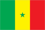
- three equal vertical bands of green (hoist side), yellow, and red with a small green five-pointed star centered in the yellow band; green represents Islam, progress, and hope; yellow signifies natural wealth and progress; red symbolizes sacrifice and determination; the star denotes unity and hope uses the popular Pan-African colors of Ethiopia; the colors from left to right are the same as those of neighboring Mali and the reverse of those on the flag of neighboring Guinea
- note
- uses the popular Pan-African colors of Ethiopia; the colors from left to right are the same as those of neighboring Mali and the reverse of those on the flag of neighboring Guinea
Government type
presidential republic
Independence
4 April 1960 (from France); note - complete independence achieved upon dissolution of federation with Mali on 20 August 1960
International law organization participation
accepts compulsory ICJ jurisdiction with reservations; accepts ICCt jurisdiction
International organization participation
ACP, AfDB, AU, CD, CPLP (associate), ECOWAS, EITI (candidate country), FAO, FZ, G-15, G-77, IAEA, IBRD, ICAO, ICC (national committees), ICCt, ICRM, IDA, IDB, IFAD, IFC, IFRCS, ILO, IMF, IMO, IMSO, Interpol, IOC, IOM, IPU, ISO, ITSO, ITU, ITUC (NGOs), MIGA, MINUSMA, MONUSCO, NAM, OIC, OIF, OPCW, PCA, UN, UNAMID, UNCTAD, UNESCO, UNHCR, UNIDO, UNMIL, UNMISS, UNOCI, UNWTO, UPU, WADB (regional), WAEMU, WCO, WFTU (NGOs), WHO, WIPO, WMO, WTO
Judicial branch
- Supreme Court or Cour Supreme (consists of the president and 12 judges and organized into civil and commercial, criminal, administrative, and social chambers); Constitutional Council or Conseil Constitutionelle (consists of 5 members including the court president, vice-president, and 3 judges) Supreme Court judges' appointed by the president of the republic upon recommendation of the Higher Council of the Judiciary, a body chaired by the president; judge tenure NA; Constitutional Council members appointed by the president to serve 6-year terms with the renewal of 2 members every 2 years High Court of Justice (for crime of high treason by the president); Courts of Appeal; Court of Auditors; assize courts (4); regional and district Courts, Labor Court
- highest court(s)
- Supreme Court or Cour Supreme (consists of the president and 12 judges and organized into civil and commercial, criminal, administrative, and social chambers); Constitutional Council or Conseil Constitutionelle (consists of 5 members including the court president, vice-president, and 3 judges)
- judge selection and term of office
- Supreme Court judges' appointed by the president of the republic upon recommendation of the Higher Council of the Judiciary, a body chaired by the president; judge tenure NA; Constitutional Council members appointed by the president to serve 6-year terms with the renewal of 2 members every 2 years
- subordinate courts
- High Court of Justice (for crime of high treason by the president); Courts of Appeal; Court of Auditors; assize courts (4); regional and district Courts, Labor Court
Legal system
civil law system based on French law; judicial review of legislative acts in Constitutional Court
Legislative branch
- unicameral National Assembly or Assemblee Nationale (150 seats; 90 members directly elected in single- and multi-seat constituencies by simple majority vote and 60 directly elected in single- and multi-seat constituencies by proportional representation vote; members serve 5-year terms) National Assembly - last held on 1 July 2012 (next to be held in 2017) National Assembly results - percent of vote by party - NA; seats by party - Benno Bokk Yakaar coalition 119, PDS 12, Bokk Gis Gis coalition 4, MCRN-Bes Du Nakk 4, PVD 2, MRSD 2, URD 1, AJ/PADS 1, other 5
- description
- unicameral National Assembly or Assemblee Nationale (150 seats; 90 members directly elected in single- and multi-seat constituencies by simple majority vote and 60 directly elected in single- and multi-seat constituencies by proportional representation vote; members serve 5-year terms)
- election results
- National Assembly results - percent of vote by party - NA; seats by party - Benno Bokk Yakaar coalition 119, PDS 12, Bokk Gis Gis coalition 4, MCRN-Bes Du Nakk 4, PVD 2, MRSD 2, URD 1, AJ/PADS 1, other 5
- elections
- National Assembly - last held on 1 July 2012 (next to be held in 2017)
National anthem
- "Pincez Tous vos Koras, Frappez les Balafons" (Pluck Your Koras, Strike the Balafons) Leopold Sedar SENGHOR/Herbert PEPPER adopted 1960; lyrics written by Leopold Sedar SENGHOR, Senegal's first president; the anthem sometimes played incorporating the Koras (harp-like stringed instruments) and Balafons (types of xylophones) mentioned in the title
- lyrics/music
- Leopold Sedar SENGHOR/Herbert PEPPER
- name
- "Pincez Tous vos Koras, Frappez les Balafons" (Pluck Your Koras, Strike the Balafons)
- note
- adopted 1960; lyrics written by Leopold Sedar SENGHOR, Senegal's first president; the anthem sometimes played incorporating the Koras (harp-like stringed instruments) and Balafons (types of xylophones) mentioned in the title
National holiday
Independence Day, 4 April (1960)
National symbol(s)
- lion; national colors: green, yellow, red
- lion; national colors
- green, yellow, red
Political parties and leaders
Alliance for the Republic-Yakaar or APR-Yakaar [Macky SALL] Alliance of Forces of Progress or AFP [Moustapha NIASSE] And-Jef/African Party for Democracy and Socialism or AJ/PADS [Mamadou DIOP] And-Jef/African Party for Democracy and Socialism or AJ/PADS-A [Landing SAVANE] Bokk Gis Gis coalition [Pape DIOP] Citizen Movement for National Reform or MCRN-Bes Du Nakk Democratic League-Labor Party Movement or LD-MPT [Mamadou NDOYE] Front for Socialism and Democracy/Benno Jubel or FSD/BJ [Cheikh Abdoulaye Bamba DIEYE] Gainde Centrist Bloc or BGC [Jean-Paul DIAS] Grand Party or GP [Malick GACKOU] Independence and Labor Party or PIT [Magatte THIAM] Jef-Jel [Talla SYLLA] National Democratic Rally or RND [Madior DIOUF] Party for Truth and Development or PVD [Cheikh Ahmadou Kara MBAKE] People's Labor Party or PTP [El Hadji DIOUF] Reform Party or PR [Abdourahim AGNE] Republican Movement for Socialism and Democracy or MRSD Rewmi Party [Idrissa SECK] Senegalese Democratic Party or PDS [Abdoulaye WADE] Socialist Party or PS [Ousmane Tanor DIENG] Union for Democratic Renewal or URD [Djibo Leyti KA]
Political pressure groups and leaders
- Catholic clergy; labor; religious groups; students; Sufi brotherhoods, including the Mourides and Tidjanes; teachers
- other
- Catholic clergy; labor; religious groups; students; Sufi brotherhoods, including the Mourides and Tidjanes; teachers
Suffrage
18 years of age; universal
Economy
Agriculture - products
peanuts, millet, corn, sorghum, rice, cotton, tomatoes, green vegetables; cattle, poultry, pigs; fish
Budget
- $3.424 billion $4.081 billion (2015 est.)
- expenditures
- $4.081 billion (2015 est.)
- revenues
- $3.424 billion
Budget surplus (+) or deficit (-)
-4.8% of GDP (2015 est.)
Central bank discount rate
0.25% (31 December 2010) 4.25% (31 December 2009)
Commercial bank prime lending rate
14.3% (31 December 2015 est.) 14.5% (31 December 2014 est.)
Current account balance
-$1.033 billion (2015 est.) -$1.373 billion (2014 est.)
Debt - external
$5.735 billion (31 December 2015 est.) $5.655 billion (31 December 2014 est.)
Distribution of family income - Gini index
40.3 (2011)
Economy - overview
Senegal’s economy is driven by mining, construction, tourism, fisheries and agriculture, which is the primary source of employment in rural areas. The country's key export industries include phosphate mining, fertilizer production, agricultural products and commercial fishing and it is also working on oil exploration projects. Senegal relies heavily on donor assistance, remittances and foreign direct investment. For the first time in the past twelve years, Senegal reached a growth rate of 6.5% in 2015 due in part to a buoyant performance in agriculture because of higher rainfall and productivity in the sector. President Macky SALL, who was elected in March 2012 under a reformist policy agenda, inherited an economy with high energy costs, a challenging business environment, and a culture of overspending. President SALL unveiled an ambitious economic plan, the Emerging Senegal Plan (ESP), which aims to implement priority economic reforms and investment projects to increase economic growth while preserving macroeconomic stability and debt sustainability. Bureaucratic bottlenecks and a challenging business climate are among the perennial challenges that may slow the implementation of this plan. Senegal is receiving technical support from the IMF from 2015-2017 under a Policy Support Instrument (PSI) to assist with implementation of the ESP. The PSI implementation continues to be satisfactory as concluded by the IMF’s second review mission in March 2016. Investors have signaled confidence in the country through Senegal’s successful Eurobond issuances in recent years, including in 2014. The government will focus on 19 projects under the ESP for the 2016 budget to continue the structural transformation of the economy. These 19 projects include the Thies-Touba Highway, including the new airport- Mbour-Thies Highway. Senegal will increase the national family allowances program and the community development emergency program in 2016. Electricity supply is a chief constraint for Senegal’s development. Electricity prices in Senegal are among the highest in the world. Power Africa, a program led by USAID and OPIC, plans to increase the current 500 mW of generating capacity to over 1,000 mW in the next three to five years. Recent gas discoveries on the Senegal-Mauritanian border, as well as just south of Dakar, will help alleviate some of the energy shortages.
Exchange rates
Communaute Financiere Africaine francs (XOF) per US dollar - 591.45 (2015 est.) 494.42 (2014 est.) 494.42 (2013 est.) 510.53 (2012 est.) 471.87 (2011 est.)
Exports
$2.31 billion (2015 est.) $2.498 billion (2014 est.)
Exports - commodities
fish, groundnuts (peanuts), petroleum products, phosphates, cotton
Exports - partners
Mali 12.8%, Switzerland 9.7%, India 5.9%, Cote dIvoire 5.3%, China 5.1%, UAE 4.1%, France 4.1% (2015)
Fiscal year
calendar year
GDP - composition, by end use
- 75.4% 15.1% 27.2% -0.3% 26.9% -44.3% (2015 est.)
- exports of goods and services
- 26.9%
- government consumption
- 15.1%
- household consumption
- 75.4%
- imports of goods and services
- -44.3% (2015 est.)
- investment in fixed capital
- 27.2%
- investment in inventories
- -0.3%
GDP - composition, by sector of origin
- 15.9% 23.8% 60.4% (2015 est.)
- agriculture
- 15.9%
- industry
- 23.8%
- services
- 60.4% (2015 est.)
GDP - per capita (PPP)
- $2,500 (2015 est.) $2,400 (2014 est.) $2,300 (2013 est.) data are in 2015 US dollars
- note
- data are in 2015 US dollars
GDP - real growth rate
6.5% (2015 est.) 4.3% (2014 est.) 3.6% (2013 est.)
GDP (official exchange rate)
$13.67 billion (2015 est.)
GDP (purchasing power parity)
- $36.69 billion (2015 est.) $34.45 billion (2014 est.) $33.02 billion (2013 est.) data are in 2015 US dollars
- note
- data are in 2015 US dollars
Gross national saving
19.4% of GDP (2015 est.) 16.1% of GDP (2014 est.) 17.7% of GDP (2013 est.)
Household income or consumption by percentage share
- 2.5% 31.1% (2011)
- highest 10%
- 31.1% (2011)
- lowest 10%
- 2.5%
Imports
$4.918 billion (2015 est.) $5.696 billion (2014 est.)
Imports - commodities
food and beverages, capital goods, fuels
Imports - partners
France 17.9%, China 10%, Nigeria 8.7%, India 5.6%, Spain 4.9%, Netherlands 4.5% (2015)
Industrial production growth rate
7.7% (2015 est.)
Industries
agricultural and fish processing, phosphate mining, fertilizer production, petroleum refining, zircon, and gold mining, construction materials, ship construction and repair
Inflation rate (consumer prices)
0.1% (2015 est.) -1.1% (2014 est.)
Labor force
6.521 million (2015 est.)
Labor force - by occupation
- 77.5% 22.5% (2007 est.)
- agriculture
- 77.5%
- industry and services
- 22.5% (2007 est.)
Market value of publicly traded shares
$NA
Population below poverty line
46.7% (2011 est.)
Public debt
54.6% of GDP (2015 est.) 53.1% of GDP (2014 est.)
Reserves of foreign exchange and gold
$2.012 billion (31 December 2015 est.) $2.038 billion (31 December 2014 est.)
Stock of broad money
$6.351 billion (31 December 2015 est.) $6.446 billion (31 December 2014 est.)
Stock of domestic credit
$4.868 billion (31 December 2015 est.) $4.882 billion (31 December 2014 est.)
Stock of narrow money
$4.264 billion (31 December 2015 est.) $3.931 billion (31 December 2014 est.)
Taxes and other revenues
25.1% of GDP (2015 est.)
Unemployment rate
48% (2007 est.)
Energy
Carbon dioxide emissions from consumption of energy
7.3 million Mt (2013 est.)
Crude oil - exports
0 bbl/day (2013 est.)
Crude oil - imports
17,240 bbl/day (2013 est.)
Crude oil - production
0 bbl/day (2015 est.)
Crude oil - proved reserves
0 bbl (1 January 2016 es)
Electricity - consumption
3 billion kWh (2014 est.)
Electricity - exports
0 kWh (2013 est.)
Electricity - from fossil fuels
99.7% of total installed capacity (2012 est.)
Electricity - from hydroelectric plants
0% of total installed capacity (2012 est.)
Electricity - from nuclear fuels
0% of total installed capacity (2012 est.)
Electricity - from other renewable sources
0.3% of total installed capacity (2012 est.)
Electricity - imports
0 kWh (2013 est.)
Electricity - installed generating capacity
1 million kW (2014 est.)
Electricity - production
3.5 billion kWh (2014 est.)
Electricity access
- 6,400,000 55% 90% 28% (2013)
- electrification - rural areas
- 28% (2013)
- electrification - total population
- 55%
- electrification - urban areas
- 90%
- population without electricity
- 6,400,000
Natural gas - consumption
46 million cu m (2014 est.)
Natural gas - exports
0 cu m (2013 est.)
Natural gas - imports
0 cu m (2013 est.)
Natural gas - production
46 million cu m (2014 est.)
Natural gas - proved reserves
9.911 billion cu m (1 January 2012 es)
Refined petroleum products - consumption
41,000 bbl/day (2014 est.)
Refined petroleum products - exports
3,743 bbl/day (2013 est.)
Refined petroleum products - imports
26,560 bbl/day (2013 est.)
Refined petroleum products - production
16,120 bbl/day (2013 est.)
Communications
Broadcast media
state-run Radiodiffusion Television Senegalaise (RTS) operates 2 TV stations; a few private TV subscription channels rebroadcast foreign channels without providing any local news or programs; RTS operates a national radio network and a number of regional FM stations; many community and private-broadcast radio stations are available; transmissions of at least 2 international broadcasters are accessible on FM in Dakar (2007)
Internet country code
.sn
Internet users
- 3.031 million 21.7% (July 2015 est.)
- percent of population
- 21.7% (July 2015 est.)
- total
- 3.031 million
Telephone system
- good system with microwave radio relay, coaxial cable and fiber-optic cable in trunk system above-average urban system with a fiber-optic network; about two-thirds of all fixed-line connections are in Dakar where a call-center industry is emerging; expansion of fixed-line services in rural areas needed; mobile-cellular service is expanding rapidly country code - 221; the SAT-3/WASC fiber-optic cable provides connectivity to Europe and Asia while Atlantis-2 provides connectivity to South America; satellite earth station - 1 Intelsat (Atlantic Ocean) (2015)
- domestic
- above-average urban system with a fiber-optic network; about two-thirds of all fixed-line connections are in Dakar where a call-center industry is emerging; expansion of fixed-line services in rural areas needed; mobile-cellular service is expanding rapidly
- general assessment
- good system with microwave radio relay, coaxial cable and fiber-optic cable in trunk system
- international
- country code - 221; the SAT-3/WASC fiber-optic cable provides connectivity to Europe and Asia while Atlantis-2 provides connectivity to South America; satellite earth station - 1 Intelsat (Atlantic Ocean) (2015)
Telephones - fixed lines
- 300,219 2 (July 2015 est.)
- subscriptions per 100 inhabitants
- 2 (July 2015 est.)
- total subscriptions
- 300,219
Telephones - mobile cellular
- 14.959 million 107 (July 2015 est.)
- subscriptions per 100 inhabitants
- 107 (July 2015 est.)
- total
- 14.959 million
Transportation
Airports
20 (2013)
Airports - with paved runways
- 1 (2013)
- 1,524 to 2,437 m
- 6
- 914 to 1,523 m
- 1 (2013)
- over 3,047 m
- 2
- total
- 9
Airports - with unpaved runways
- 1 (2013)
- 1,524 to 2,437 m
- 7
- 914 to 1,523 m
- 3
- total
- 11
- under 914 m
- 1 (2013)
Civil aircraft registration country code prefix
6V (2016)
Merchant marine
- passenger/cargo 1 (2010)
- by type
- passenger/cargo 1 (2010)
- total
- 1
National air transport system
- 115,355 3,095,523 mt-km (2015)
- annual freight traffic on registered air carriers
- 3,095,523 mt-km (2015)
- annual passenger traffic on registered air carriers
- 115,355
Pipelines
gas 43 km; refined products 8 km (2013)
Ports and terminals
- Dakar
- major seaport(s)
- Dakar
Railways
- 906 km 906 km 1.000-m gauge (2014)
- narrow gauge
- 906 km 1.000-m gauge (2014)
- total
- 906 km
Roadways
- 15,000 km 5,300 km (includes 7 km of expressways) 9,700 km (2015)
- paved
- 5,300 km (includes 7 km of expressways)
- total
- 15,000 km
- unpaved
- 9,700 km (2015)
Waterways
1,000 km (primarily on the Senegal, Saloum, and Casamance Rivers) (2012)
Military and Security
Military branches
- Senegalese Armed Forces: Army, Senegalese National Navy (Marine Senegalaise, MNS), Senegalese Air Force (Armee de l'Air du Senegal) (2013)
- Senegalese Armed Forces
- Army, Senegalese National Navy (Marine Senegalaise, MNS), Senegalese Air Force (Armee de l'Air du Senegal) (2013)
Military service age and obligation
18 years of age for voluntary military service; 20 years of age for selective conscript service; 2-year service obligation; women have been accepted into military service since 2008 (2013)
Transnational Issues
Disputes - international
The Gambia and Guinea-Bissau attempt to stem separatist violence, cross border raids, and arms smuggling into their countries from southern Senegal's Casamance region
Illicit drugs
transshipment point for Southwest and Southeast Asian heroin and South American cocaine moving to Europe and North America; illicit cultivator of cannabis
Refugees and internally displaced persons
- 13,687 (Mauritania) (2015) 24,000 (clashes between government troops and separatists in Casamance region) (2015)
- IDPs
- 24,000 (clashes between government troops and separatists in Casamance region) (2015)
- refugees (country of origin)
- 13,687 (Mauritania) (2015)