1996 Edition
CIA World Factbook 1996 (Project Gutenberg)
Introduction
Description
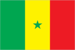
three equal vertical bands of green (hoist side), yellow, and red with a small green five-pointed star centered in the yellow band; uses the popular pan-African colors of Ethiopia
Location
14 00 N, 14 00 W -- Western Africa, bordering the North Atlantic Ocean, between Guinea-Bissau and Mauritania Flag ----
Geography
Area
- comparative area
- slightly smaller than South Dakota
- land area
- 192,000 sq km
- total area
- 196,190 sq km
Climate
tropical; hot, humid; rainy season (December to April) has strong southeast winds; dry season (May to November) dominated by hot, dry, harmattan wind
Coastline
531 km
Environment
- current issues
- wildlife populations threatened by poaching; deforestation; overgrazing; soil erosion; desertification; overfishing
- international agreements
- party to - Biodiversity, Climate Change, Desertification, Endangered Species, Hazardous Wastes, Law of the Sea, Marine Life Conservation, Nuclear Test Ban, Ozone Layer Protection, Wetlands; signed, but not ratified - Marine Dumping
- natural hazards
- lowlands seasonally flooded; periodic droughts
Geographic coordinates
14 00 N, 14 00 W
Geographic note
The Gambia is almost an enclave of Senegal
International disputes
short section of the boundary with The Gambia is indefinite; boundary with Mauritania in dispute
Irrigated land
1,800 sq km (1989 est.)
Land boundaries
- border countries
- The Gambia 740 km, Guinea 330 km, Guinea-Bissau 338 km, Mali 419 km, Mauritania 813 km
- total
- 2,640 km
Land use
- arable land
- 27%
- forest and woodland
- 31%
- meadows and pastures
- 30%
- other
- 12%
- permanent crops
- 0%
Location
Western Africa, bordering the North Atlantic Ocean, between Guinea-Bissau and Mauritania
Map references
Africa
Maritime claims
- contiguous zone
- 24 nm
- continental shelf
- 200 nm or to the edge of the continental margin
- exclusive economic zone
- 200 nm
- territorial sea
- 12 nm
Natural resources
fish, phosphates, iron ore
Terrain
- generally low, rolling, plains rising to foothills in southeast
- highest point
- unnamed location in the Futa Jaldon foothills 581 m
- lowest point
- Atlantic Ocean 0 m
People and Society
Age structure
0-14 years: 48% (male 2,188,338; female 2,197,015) 15-64 years: 49% (male 2,111,330; female 2,336,987) 65 years and over: 3% (male 128,939; female 130,140) (July 1996 est.)
Birth rate
45.46 births/1,000 population (1996 est.)
Death rate
11.76 deaths/1,000 population (1996 est.)
Ethnic divisions
Wolof 36%, Fulani 17%, Serer 17%, Toucouleur 9%, Diola 9%, Mandingo 9%, European and Lebanese 1%, other 2%
Infant mortality rate
64 deaths/1,000 live births (1996 est.)
Languages
French (official), Wolof, Pulaar, Diola, Mandingo
Life expectancy at birth
- female
- 59.3 years (1996 est.)
- male
- 53.75 years
- total population
- 56.49 years
Literacy
- age 15 and over can read and write (1995 est.)
- female
- 23.2%
- male
- 43%
- total population
- 33.1%
Nationality
- adjective
- Senegalese
- noun
- Senegalese (singular and plural)
Net migration rate
0 migrant(s)/1,000 population (1996 est.)
Population
9,092,749 (July 1996 est.)
Population growth rate
3.37% (1996 est.)
Religions
Muslim 92%, indigenous beliefs 6%, Christian 2% (mostly Roman Catholic)
Sex ratio
- all ages
- 0.95 male(s)/female (1996 est.)
- at birth
- 1.03 male(s)/female
- under 15 years
- 1 male(s)/female 15-64 years: 0.9 male(s)/female 65 years and over: 0.99 male(s)/female
Total fertility rate
6.31 children born/woman (1996 est.)
Government
Administrative divisions
10 regions (regions, singular - region); Dakar, Diourbel, Fatick, Kaolack, Kolda, Louga, Saint-Louis, Tambacounda, Thies, Ziguinchor
Capital
Dakar
Constitution
3 March 1963, revised 1991
Data code
SG
Diplomatic representation in US
- chancery
- 2112 Wyoming Avenue NW, Washington, DC 20008
- chief of mission
- Ambassador Mamadou Mansour SECK
- telephone
- [1] (202) 234-0540, 0541
Executive branch
- cabinet
- Council of Ministers was appointed by the prime minister in consultation with the president
- chief of state
- President Abdou DIOUF (since 1 January 1981) was elected for a seven-year term by universal suffrage; election last held 21 February 1993 (next to be held NA February 2000); results - Abdou DIOUF (PS) 58.4%, Abdoulaye WADE (PDS) 32.03%, other 9.57%
- head of government
- Prime Minister Habib THIAM (since 7 April 1991) was appointed by the president
FAX
[221] 22 29 91
Flag
three equal vertical bands of green (hoist side), yellow, and red with a small green five-pointed star centered in the yellow band; uses the popular pan-African colors of Ethiopia
Independence
20 August 1960 (from France; The Gambia and Senegal signed an agreement on 12 December 1981 that called for the creation of a loose confederation to be known as Senegambia, but the agreement was dissolved on 30 September 1989)
International organization participation
ACCT, ACP, AfDB, CCC, ECA, ECOWAS, FAO, FZ, G-15, G-77, IAEA, IBRD, ICAO, ICC, ICFTU, ICRM, IDA, IDB, IFAD, IFC, IFRCS, ILO, IMF, IMO, Inmarsat, Intelsat, Interpol, IOC, ITU, NAM, OAU, OIC, PCA, UN, UNAMIR, UNAVEM III, UNCRO, UNCTAD, UNESCO, UNIDO, UNIKOM, UPU, WADB, WCL, WFTU, WHO, WIPO, WMO, WToO, WTrO
Judicial branch
Supreme Court (Cour Supreme)
Legal system
based on French civil law system; judicial review of legislative acts in Supreme Court, which also audits the government's accounting office; has not accepted compulsory ICJ jurisdiction
Legislative branch
unicameral
Name of country
- conventional long form
- Republic of Senegal
- conventional short form
- Senegal
- local long form
- Republique du Senegal
- local short form
- Senegal
National Assembly (Assemblee Nationale)
elections last held 9 May 1993 (next to be held NA May 1998); results - PS 70%, PDS 23%, other 7%; seats - (120 total) PS 84, PDS 27, LD-MPT 3, Let Us Unite Senegal 3, PIT 2, UDS-R 1
National holiday
Independence Day, 4 April (1960)
Other political or pressure groups
students; teachers; labor; Muslim Brotherhoods
Political parties and leaders
Socialist Party (PS), President Abdou DIOUF; Senegalese Democratic Party (PDS), Abdoulaye WADE; Democratic League-Labor Party Movement (LD-MPT), Dr. Abdoulaye BATHILY; Independent Labor Party (PIT), Amath DANSOKHO; Senegalese Democratic Union-Renewal (UDS-R), Mamadou Puritain FALL; Let Us Unite Senegal (coalition of African Party for Democracy and Socialism and National Democratic Rally); other small uninfluential parties
Suffrage
18 years of age; universal
Type of government
republic under multiparty democratic rule
US diplomatic representation
- chief of mission
- Ambassador Mark JOHNSON
- embassy
- Avenue Jean XXIII at the corner of Avenue Kleber, Dakar
- mailing address
- B. P. 49, Dakar
- telephone
- [221] 23 42 96, 23 34 24
Economy
Agriculture
peanuts, millet, corn, sorghum, rice, cotton, tomatoes, green vegetables; cattle, poultry, pigs; fish catch of 409,000 metric tons in 1992
Budget
- expenditures
- $197.7 billion, including capital expenditures of $NA (1996 est.)
- revenues
- $876 million
Currency
1 Communaute Financiere Africaine franc (CFAF) = 100 centimes
Economic aid
- recipient
- ODA, $439 million (1993)
Economic overview
In 1994 Senegal embarked on its most concerted structural adjustment effort yet to exploit the 50% devaluation of the currencies of the 14 Francophone African nations on 12 January of that year. After years of foot-dragging, the government has passed a liberalized labor code which should lower the cost of labor and improve the manufacturing sector's competitiveness. Inroads also have been made in closing tax loopholes, eliminating monopoly power in several sectors, and privatizing state owned firms. At the same time, the government is holding the line on current fiscal expenditure under the watchful eyes of international organizations on which it depends for substantial support. The IMF, in mid-1995, announced that the government met most economic targets as called for in its Enhanced Structural Adjustment Facility agreement and released the second $50 million tranche. The country's narrow resource base, environmental degradation, and untamed population growth will continue to hold back improvement in living standards over the medium term.
Electricity
- capacity
- 230,000 kW
- consumption per capita
- 79 kWh (1993)
- production
- 720 million kWh
Exchange rates
- CFA francs (CFAF) per US$1 - 500.56 (January 1996), 499.15 (1995), 555.20 (1994), 283.16 (1993), 264.69 (1992), 282.11 (1991)
- note
- beginning 12 January 1994, the CFA franc was devalued to CFAF 100 per French franc from CFAF 50 at which it had been fixed since 1948
Exports
- $940 million (f.o.b., 1994 est.)
- commodities
- fish, ground nuts (peanuts), petroleum products, phosphates, cotton
- partners
- France, other EU countries, Cote d'Ivoire, Mali
External debt
$3.8 billion (1993)
Fiscal year
calendar year
GDP
purchasing power parity - $14.5 billion (1995 est.)
GDP composition by sector
- agriculture
- NA%
- industry
- NA%
- services
- NA%
GDP per capita
$1,600 (1995 est.)
GDP real growth rate
4.5% (1995 est.)
Illicit drugs
transshipment point for Southwest and Southeast Asian heroin moving to Europe and North America; illicit cultivator of cannabis
Imports
- $1.1 billion (c.i.f., 1994 est.)
- commodities
- foods and beverages, consumer goods, capital goods, petroleum
- partners
- France, other EU countries, Nigeria, Cote d'Ivoire, Algeria, China, Japan
Industrial production growth rate
NA%
Industries
agricultural and fish processing, phosphate mining, petroleum refining, construction materials
Inflation rate (consumer prices)
6.1% (1995)
Labor force
- 2.509 million (77% are engaged in subsistence farming; 175,000 wage earners)
- by occupation
- private sector 40%, government and parapublic 60%
Unemployment rate
NA%
Communications
Branches
Army, Navy, Air Force, National Gendarmerie, National Police (Surete Nationale)
Defense expenditures
exchange rate conversion - $82 million, 2.1% of GDP (1996 est.)
Manpower availability
- males age 15-49
- 1,864,239
- males fit for military service
- 973,170
- males reach military age (18) annually
- 90,154 (1996 est.)
Radio broadcast stations
AM 8, FM 0, shortwave 0
Radios
850,000 (1993 est.)
Telephone system
- domestic
- above-average urban system; microwave radio relay and cable trunk system
- international
- 3 submarine cables; satellite earth station - 1 Intelsat (Atlantic Ocean)
Telephones
55,000 (1993 est.)
Television broadcast stations
1
Televisions
61,000 (1993 est.) Defense
Transportation
Airports
- total
- 17
- with paved runways 1 524 to 2 437 m
- 8
- with paved runways 914 to 1 523 m
- 1
- with paved runways over 3 047 m
- 1
- with paved runways under 914 m
- 1
- with unpaved runways 1 524 to 2 437 m
- 4
- with unpaved runways 914 to 1 523 m
- 2 (1995 est.)
Highways
- paved
- 3,900 km
- total
- 13,850 km
- unpaved
- 9,950 km (1990 est.)
Merchant marine
- total
- 1 bulk ship (1,000 GRT or over) totaling 1,995 GRT/3,775 DWT (1995 est.)
Ports
Dakar, Kaolack, Matam, Podor, Richard-Toll, Saint-Louis, Ziguinchor
Railways
- narrow gauge
- 904 km 1.000-meter gauge (70 km double track) (1995)
- total
- 904 km
Waterways
897 km total; 785 km on the Senegal river, and 112 km on the Saloum