2012 Edition
CIA World Factbook 2012 Archive (HTML)
Introduction
Background
Discovered and claimed by Portugal in the late 15th century, the islands' sugar-based economy gave way to coffee and cocoa in the 19th century - all grown with plantation slave labor, a form of which lingered into the 20th century. While independence was achieved in 1975, democratic reforms were not instituted until the late 1980s. The country held its first free elections in 1991, but frequent internal wrangling between the various political parties precipitated repeated changes in leadership and two failed coup attempts in 1995 and 2003. In 2012, three opposition parties combined in a no confidence vote to bring down the majority government of former Prime Minister Patrice TROVOADA. The new government of Prime Minister Gabriel Arcanjo Ferreira DA COSTA is entirely composed of opposition party members with limited experience in governance. The recent discovery of oil in the Gulf of Guinea promises to attract increased attention to the small island nation.
Geography
Area
- 964 sq km 964 sq km 0 sq km
- total
- 964 sq km
- water
- 0 sq km
Area - comparative
more than five times the size of Washington, DC
Climate
tropical; hot, humid; one rainy season (October to May)
Coastline
209 km
Elevation extremes
- Atlantic Ocean 0 m Pico de Sao Tome 2,024 m
- highest point
- Pico de Sao Tome 2,024 m
- lowest point
- Atlantic Ocean 0 m
Environment - current issues
deforestation; soil erosion and exhaustion
Environment - international agreements
- Biodiversity, Climate Change, Climate Change-Kyoto Protocol, Desertification, Endangered Species, Environmental Modification, Law of the Sea, Ozone Layer Protection, Ship Pollution, Wetlands none of the selected agreements
- party to
- Biodiversity, Climate Change, Climate Change-Kyoto Protocol, Desertification, Endangered Species, Environmental Modification, Law of the Sea, Ozone Layer Protection, Ship Pollution, Wetlands
- signed, but not ratified
- none of the selected agreements
Geographic coordinates
1 00 N, 7 00 E
Geography - note
the smallest country in Africa; the two main islands form part of a chain of extinct volcanoes and both are mountainous
Irrigated land
100 sq km (2003)
Land boundaries
0 km
Land use
- 8.33% 48.96% 42.71% (2005)
- arable land
- 8.33%
- other
- 42.71% (2005)
- permanent crops
- 48.96%
Location
Central Africa, islands in the Gulf of Guinea, straddling the Equator, west of Gabon
Map references
Africa
Maritime claims
- measured from claimed archipelagic baselines 12 nm 200 nm
- exclusive economic zone
- 200 nm
- territorial sea
- 12 nm
Natural hazards
NA
Natural resources
fish, hydropower
Terrain
volcanic, mountainous
People and Society
Age structure
- 44.4% (male 41,326/ female 39,926) 52.6% (male 47,458/ female 48,808) 3.1% (male 2,588/ female 3,070) (2012 est.)
- 0-14 years
- 44.4% (male 41,326/ female 39,926)
- 15-64 years
- 52.6% (male 47,458/ female 48,808)
- 65 years and over
- 3.1% (male 2,588/ female 3,070) (2012 est.)
Birth rate
37.02 births/1,000 population (2012 est.)
Children under the age of 5 years underweight
13.1% (2009)
Death rate
7.93 deaths/1,000 population (July 2012 est.)
Education expenditures
NA
Ethnic groups
mestico, angolares (descendants of Angolan slaves), forros (descendants of freed slaves), servicais (contract laborers from Angola, Mozambique, and Cape Verde), tongas (children of servicais born on the islands), Europeans (primarily Portuguese)
Health expenditures
7.1% of GDP (2009)
HIV/AIDS - adult prevalence rate
NA
HIV/AIDS - deaths
NA
HIV/AIDS - people living with HIV/AIDS
NA
Hospital bed density
3.2 beds/1,000 population (2006)
Infant mortality rate
- 51.83 deaths/1,000 live births 53.89 deaths/1,000 live births 49.71 deaths/1,000 live births (2012 est.)
- female
- 49.71 deaths/1,000 live births (2012 est.)
- total
- 51.83 deaths/1,000 live births
Languages
Portuguese (official)
Life expectancy at birth
- 63.49 years 62.27 years 64.74 years (2012 est.)
- female
- 64.74 years (2012 est.)
- total population
- 63.49 years
Literacy
- age 15 and over can read and write 84.9% 92.2% 77.9% (2001 census)
- definition
- age 15 and over can read and write
- female
- 77.9% (2001 census)
- male
- 92.2%
- total population
- 84.9%
Major cities - population
SAO TOME (capital) 60,000 (2009)
Major infectious diseases
- high bacterial diarrhea, hepatitis A, and typhoid fever malaria rabies (2009)
- animal contact disease
- rabies (2009)
- degree of risk
- high
- food or waterborne diseases
- bacterial diarrhea, hepatitis A, and typhoid fever
- vectorborne disease
- malaria
Maternal mortality rate
70 deaths/100,000 live births (2010)
Median age
- 17.6 years 17.2 years 18.1 years (2012 est.)
- female
- 18.1 years (2012 est.)
- male
- 17.2 years
- total
- 17.6 years
Nationality
- Sao Tomean(s) Sao Tomean
- adjective
- Sao Tomean
- noun
- Sao Tomean(s)
Net migration rate
-9.14 migrant(s)/1,000 population (2012 est.)
Physicians density
0.49 physicians/1,000 population (2004)
Population
183,176 (July 2012 est.)
Population growth rate
1.996% (2012 est.)
Religions
Catholic 70.3%, Evangelical 3.4%, New Apostolic 2%, Adventist 1.8%, other 3.1%, none 19.4% (2001 census)
Sanitation facility access
- urban: 30% of population rural: 19% of population total: 26% of population urban: 70% of population rural: 81% of population total: 74% of population
- rural
- 81% of population
- total
- 74% of population
- urban
- 70% of population
School life expectancy (primary to tertiary education)
- 11 years 11 years 11 years (2010)
- female
- 11 years (2010)
- male
- 11 years
- total
- 11 years
Sex ratio
- 1.03 male(s)/female 1.03 male(s)/female 0.97 male(s)/female 0.84 male(s)/female 1 male(s)/female (2011 est.)
- 15-64 years
- 0.97 male(s)/female
- 65 years and over
- 0.84 male(s)/female
- at birth
- 1.03 male(s)/female
- total population
- 1 male(s)/female (2011 est.)
- under 15 years
- 1.03 male(s)/female
Total fertility rate
4.94 children born/woman (2012 est.)
Urbanization
- 62% of total population (2010) 2.8% annual rate of change (2010-15 est.)
- rate of urbanization
- 2.8% annual rate of change (2010-15 est.)
- urban population
- 62% of total population (2010)
Government
Administrative divisions
2 provinces; Principe, Sao Tome Principe has had self government since 29 April 1995
Capital
- Sao Tome 0 20 N, 6 44 E UTC 0 (5 hours ahead of Washington, DC during Standard Time)
- geographic coordinates
- 0 20 N, 6 44 E
- name
- Sao Tome
- time difference
- UTC 0 (5 hours ahead of Washington, DC during Standard Time)
Constitution
approved March 1990, effective 10 September 1990
Country name
- Democratic Republic of Sao Tome and Principe Sao Tome and Principe Republica Democratica de Sao Tome e Principe Sao Tome e Principe
- conventional long form
- Democratic Republic of Sao Tome and Principe
- conventional short form
- Sao Tome and Principe
- local long form
- Republica Democratica de Sao Tome e Principe
- local short form
- Sao Tome e Principe
Diplomatic representation from the US
the US does not have an embassy in Sao Tome and Principe; the Ambassador to Gabon is accredited to Sao Tome and Principe on a nonresident basis and makes periodic visits to the islands
Diplomatic representation in the US
- Ambassador Ovidio Manuel Barbosa PEQUENO 1211 Connecticut Avenue NW, Suite 300, Washington, DC 20036 [1] (202) 775-2075, 2076 [1] (202) 775-2077
- chancery
- 1211 Connecticut Avenue NW, Suite 300, Washington, DC 20036
- chief of mission
- Ambassador Ovidio Manuel Barbosa PEQUENO
- FAX
- [1] (202) 775-2077
- telephone
- [1] (202) 775-2075, 2076
Executive branch
- President Manuel Pinto DA COSTA (since 3 September 2011) Prime Minister Gabriel Arcanjo Ferreira DA COSTA (since 12 December 2012) Council of Ministers appointed by the president on the proposal of the prime minister president elected by popular vote for a five-year term (eligible for a second term); election last held on 17 July and 7 August 2011 (next to be held in 2016); prime minister chosen by the National Assembly and approved by the president Manuel Pinto DA COSTA elected president in a run-off election; percent of vote - Manuel Pinto DA COSTA 52.9%, Evaristo CARVALHO 47.1%
- cabinet
- Council of Ministers appointed by the president on the proposal of the prime minister
- chief of state
- President Manuel Pinto DA COSTA (since 3 September 2011)
- election results
- Manuel Pinto DA COSTA elected president in a run-off election; percent of vote - Manuel Pinto DA COSTA 52.9%, Evaristo CARVALHO 47.1%
- elections
- president elected by popular vote for a five-year term (eligible for a second term); election last held on 17 July and 7 August 2011 (next to be held in 2016); prime minister chosen by the National Assembly and approved by the president
- head of government
- Prime Minister Gabriel Arcanjo Ferreira DA COSTA (since 12 December 2012)
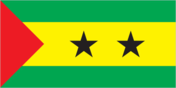
Flag description
three horizontal bands of green (top), yellow (double width), and green with two black five-pointed stars placed side by side in the center of the yellow band and a red isosceles triangle based on the hoist side; green stands for the country's rich vegetation, red recalls the struggle for independence, and yellow represents cocoa, one of the country's main agricultural products; the two stars symbolize the two main islands uses the popular Pan-African colors of Ethiopia
Government type
republic
Independence
12 July 1975 (from Portugal)
International law organization participation
has not submitted an ICJ jurisdiction declaration; non-party state to the ICCt
International organization participation
ACP, AfDB, AOSIS, AU, CD, CPLP, EITI (candidate country), FAO, G-77, IBRD, ICAO, ICRM, IDA, IFAD, IFC, IFRCS, ILO, IMF, IMO, Interpol, IOC, IOM (observer), IPU, ITU, ITUC (NGOs), NAM, OIF, OPCW, UN, UNCTAD, UNESCO, UNIDO, Union Latina, UNWTO, UPU, WCO, WHO, WIPO, WMO, WTO (observer)
Judicial branch
Supreme Court (judges are appointed by the National Assembly); Constitutional Court (five judges appointed by the National Assembly for five year terms); Court of First Instance; Audit Court
Legal system
mixed legal system of civil law base on the Portuguese model and customary law
Legislative branch
- unicameral National Assembly or Assembleia Nacional (55 seats; members elected by popular vote to serve four-year terms) last held on 1 August 2010 (next to be held in 2014) percent of vote by party - NA; seats by party - ADI 26, MLSTP-PSD 21, PCD 7, MDFM 1
- election results
- percent of vote by party - NA; seats by party - ADI 26, MLSTP-PSD 21, PCD 7, MDFM 1
- elections
- last held on 1 August 2010 (next to be held in 2014)
National anthem
- "Independencia total" (Total Independence) Alda Neves DA GRACA do Espirito Santo/Manuel dos Santos Barreto de Sousa e ALMEIDA adopted 1975
- lyrics/music
- Alda Neves DA GRACA do Espirito Santo/Manuel dos Santos Barreto de Sousa e ALMEIDA
- name
- "Independencia total" (Total Independence)
National holiday
Independence Day, 12 July (1975)
Political parties and leaders
Force for Change Democratic Movement or MDFM [Tome Soares da VERA CRUZ]; Independent Democratic Action or ADI [Patrice TROVOADA]; Movement for the Liberation of Sao Tome and Principe-Social Democratic Party or MLSTP-PSD [Rafael BRANCO]; New Way Movement or NR; Party for Democratic Convergence or PCD [Delfim NEVES]; Ue-Kedadji coalition; other small parties
Political pressure groups and leaders
- Association of Sao Tome and Principe NGOs or FONG the media
- other
- the media
Suffrage
18 years of age; universal
Economy
Agriculture - products
cocoa, coconuts, palm kernels, copra, cinnamon, pepper, coffee, bananas, papayas, beans; poultry; fish
Budget
- $111.5 million $139.9 million (2012 est.)
- expenditures
- $139.9 million (2012 est.)
- revenues
- $111.5 million
Budget surplus (+) or deficit (-)
-10.9% of GDP (2012 est.)
Central bank discount rate
16% (31 December 2009) 28% (31 December 2008)
Commercial bank prime lending rate
26% (31 December 2012 est.) 26.75% (31 December 2011 est.)
Current account balance
-$85.1 million (2012 est.) -$77.6 million (2011 est.)
Debt - external
$316.6 million (31 December 2012 est.) $266 million (31 December 2011 est.)
Economy - overview
This small, poor island economy has become increasingly dependent on cocoa since independence in 1975. Cocoa production has substantially declined in recent years because of drought and mismanagement. Sao Tome and Principe has to import fuels, most manufactured goods, consumer goods, and a substantial amount of food, making it vulnerable to fluctuations in global commodity prices. Over the years, it has had difficulty servicing its external debt and has relied heavily on concessional aid and debt rescheduling. Sao Tome and Principe benefited from $200 million in debt relief in December 2000 under the Highly Indebted Poor Countries (HIPC) program, which helped bring down the country's $300 million debt burden. In August 2005, the government signed on to a new 3-year IMF Poverty Reduction and Growth Facility (PRGF) program worth $4.3 million. In April 2011 the country completed a Threshold Country Program with The Millennium Challenge Corporation to help increase tax revenues, reform customs, and improve the business environment. Considerable potential exists for development of a tourist industry, and the government has taken steps to expand facilities in recent years. The government also has attempted to reduce price controls and subsidies. Potential exists for the development of petroleum resources in Sao Tome and Principe's territorial waters in the oil-rich Gulf of Guinea, which are being jointly developed in a 60-40 split with Nigeria, but any actual production is at least several years off. The first production licenses were sold in 2004, though a dispute over licensing with Nigeria delayed the country's receipt of more than $20 million in signing bonuses for almost a year. Maintaining control of inflation, fiscal discipline, and increasing flows of foreign direct investment into the oil sector, are the major economic problems facing the country.
Exchange rates
dobras (STD) per US dollar - 19,202 (2012 est.) 17,623 (2011 est.) 18,499 (2010 est.) 16,209 (2009) 14,900 (2008)
Exports
$11.9 million (2012 est.) $11.7 million (2011 est.)
Exports - commodities
cocoa 80%, copra, coffee, palm oil
Exports - partners
Netherlands 29.4%, Belgium 27.5%, US 8.7%, Italy 4.9%, Nigeria 4.8% (2011)
Fiscal year
calendar year
GDP - composition by sector
- 13.9% 23.7% 62.4% (2012 est.)
- agriculture
- 13.9%
- industry
- 23.7%
- services
- 62.4% (2012 est.)
GDP - per capita (PPP)
$2,300 (2012 est.) $2,300 (2011 est.) $2,200 (2010 est.) data are in 2012 US dollars
GDP - real growth rate
4.5% (2012 est.) 4.9% (2011 est.) 4.5% (2010 est.)
GDP (official exchange rate)
$261 million (2012 est.)
GDP (purchasing power parity)
$403 million (2012 est.) $385.2 million (2011 est.) $367.4 million (2010 est.) data are in 2012 US dollars
Household income or consumption by percentage share
- NA% NA%
- highest 10%
- NA%
- lowest 10%
- NA%
Imports
$121.9 million (2012 est.) $114.4 million (2011 est.)
Imports - commodities
machinery and electrical equipment, food products, petroleum products
Imports - partners
Portugal 63.8%, US 6%, Gabon 4.7%, France 4% (2011)
Industrial production growth rate
7% (2010 est.)
Inflation rate (consumer prices)
10.2% (2012 est.) 14.3% (2011 est.)
Investment (gross fixed)
50.1% of GDP (2012 est.)
Labor force
52,490 (2007)
Labor force - by occupation
- population mainly engaged in subsistence agriculture and fishing; shortages of skilled workers
- note
- population mainly engaged in subsistence agriculture and fishing; shortages of skilled workers
Market value of publicly traded shares
$NA
Population below poverty line
66.2% (2009 est.)
Public debt
76.5% of GDP (2012 est.) 74.4% of GDP (2011 est.)
Reserves of foreign exchange and gold
$44.7 million (31 December 2012 est.) $51.3 million (31 December 2011 est.)
Stock of broad money
$80.55 million (31 December 2012 est.) $82.39 million (31 December 2011 est.)
Stock of domestic credit
$87.12 million (31 December 2012 est.) $90.89 million (31 December 2011 est.)
Stock of narrow money
$37.51 million (31 December 2012 est.) $34.42 million (31 December 2011 est.)
Taxes and other revenues
42.7% of GDP (2012 est.)
Unemployment rate
NA%
Energy
Carbon dioxide emissions from consumption of energy
150,300 Mt (2010 est.)
Crude oil - exports
0 bbl/day (2009 est.)
Crude oil - imports
0 bbl/day (2009 est.)
Crude oil - production
0 bbl/day (2011 est.)
Crude oil - proved reserves
0 bbl (1 January 2010 est.)
Electricity - consumption
29.76 million kWh (2009 est.)
Electricity - exports
0 kWh (2010)
Electricity - from fossil fuels
57.1% of total installed capacity (2009 est.)
Electricity - from hydroelectric plants
42.9% of total installed capacity (2009 est.)
Electricity - from nuclear fuels
0% of total installed capacity (2009 est.)
Electricity - from other renewable sources
0% of total installed capacity (2009 est.)
Electricity - imports
0 kWh (2010 est.)
Electricity - installed generating capacity
14,000 kW (2009 est.)
Electricity - production
32 million kWh (2009 est.)
Natural gas - consumption
0 cu m (2010 est.)
Natural gas - exports
0 cu m (2010 est.)
Natural gas - imports
0 cu m (2010 est.)
Natural gas - production
0 cu m (2010 est.)
Natural gas - proved reserves
0 cu m (1 January 2012 est.)
Refined petroleum products - consumption
904 bbl/day (2011 est.)
Refined petroleum products - exports
0 bbl/day (2008 est.)
Refined petroleum products - imports
889 bbl/day (2008 est.)
Refined petroleum products - production
0 bbl/day (2008 est.)
Communications
Broadcast media
1 government-owned TV station; 1 government-owned radio station; 3 independent local radio stations authorized in 2005 with 2 operating at the end of 2006; transmissions of multiple international broadcasters are available (2007)
Internet country code
.st
Internet hosts
1,678 (2012)
Internet users
26,700 (2009)
Telephone system
- local telephone network of adequate quality with most lines connected to digital switches combined fixed-line and mobile-cellular teledensity roughly 65 telephones per 100 persons country code - 239; satellite earth station - 1 Intelsat (Atlantic Ocean)
- domestic
- combined fixed-line and mobile-cellular teledensity roughly 65 telephones per 100 persons
- general assessment
- local telephone network of adequate quality with most lines connected to digital switches
- international
- country code - 239; satellite earth station - 1 Intelsat (Atlantic Ocean)
Telephones - main lines in use
8,000 (2011)
Telephones - mobile cellular
115,000 (2011)
Transportation
Airports
2 (2012)
Airports - with paved runways
- 1 (2012)
- 1,524 to 2,437 m
- 1
- 914 to 1,523 m
- 1 (2012)
- total
- 2
Merchant marine
- bulk carrier 1, cargo 2 2 (China 1, Greece 1) (2010)
- foreign-owned
- 2 (China 1, Greece 1) (2010)
- total
- 3
Ports and terminals
Sao Tome
Roadways
- 320 km 218 km 102 km (2000)
- total
- 320 km
- unpaved
- 102 km (2000)
Military and Security
Manpower available for military service
- 39,182 39,845 (2010 est.)
- females age 16-49
- 39,845 (2010 est.)
- males age 16-49
- 39,182
Manpower fit for military service
- 27,310 29,279 (2010 est.)
- females age 16-49
- 29,279 (2010 est.)
- males age 16-49
- 27,310
Manpower reaching militarily significant age annually
- 2,076 2,003 (2010 est.)
- female
- 2,003 (2010 est.)
- male
- 2,076
Military - note
Sao Tome and Principe's army is a tiny force with almost no resources at its disposal and would be wholly ineffective operating unilaterally; infantry equipment is considered simple to operate and maintain but may require refurbishment or replacement after 25 years in tropical climates; poor pay, working conditions, and alleged nepotism in the promotion of officers have been problems in the past, as reflected in the 1995 and 2003 coups; these issues are being addressed with foreign assistance aimed at improving the army and its focus on realistic security concerns; command is exercised from the president, through the Minister of Defense, to the Chief of the Armed Forces staff (2005)
Military branches
- Armed Forces of Sao Tome and Principe (Forcas Armadas de Sao Tome e Principe, FASTP): Army, Coast Guard of Sao Tome e Principe (Guarda Costeira de Sao Tome e Principe, GCSTP); also called "Navy"), Presidential Guard (2011)
- Armed Forces of Sao Tome and Principe (Forcas Armadas de Sao Tome e Principe, FASTP)
- Army, Coast Guard of Sao Tome e Principe (Guarda Costeira de Sao Tome e Principe, GCSTP); also called "Navy"), Presidential Guard (2011)
Military expenditures
0.8% of GDP (2006)
Military service age and obligation
18 years of age (est.) (2004)
Transnational Issues
Disputes - international
none