2010 Edition
CIA World Factbook 2010 (Project Gutenberg)
Introduction
Background
Carib Indians occupied the islands for hundreds of years before the British began settlement in 1623. The islands became an associated state of the UK with full internal autonomy in 1967. The island of Anguilla rebelled and was allowed to secede in 1971. Saint Kitts and Nevis achieved independence in 1983. In 1998, a vote in Nevis on a referendum to separate from Saint Kitts fell short of the two-thirds majority needed. Nevis continues in its efforts to separate from Saint Kitts.
Geography
Area
- land
- 261 sq km
- total
- 261 sq km (Saint Kitts 168 sq km; Nevis 93 sq km)
- water
- 0 sq km
Area - comparative
1.5 times the size of Washington, DC
Climate
tropical, tempered by constant sea breezes; little seasonal temperature variation; rainy season (May to November)
Coastline
135 km
Elevation extremes
- highest point
- Mount Liamuiga 1,156 m
- lowest point
- Caribbean Sea 0 m
Environment - current issues
NA
Environment - international agreements
- party to
- Biodiversity, Climate Change, Climate Change-Kyoto Protocol, Desertification, Endangered Species, Hazardous Wastes, Law of the Sea, Marine Dumping, Ozone Layer Protection, Ship Pollution, Whaling signed, but not ratified: none of the selected agreements
Geographic coordinates
17 20 N, 62 45 W
Geography - note
with coastlines in the shape of a baseball bat and ball, the two volcanic islands are separated by a 3-km-wide channel called The Narrows; on the southern tip of long, baseball bat-shaped Saint Kitts lies the Great Salt Pond; Nevis Peak sits in the center of its almost circular namesake island and its ball shape complements that of its sister island
Irrigated land
NA
Land boundaries
0 km
Land use
- arable land
- 19.44%
- other
- 77.78% (2005)
- permanent crops
- 2.78%
Location
Caribbean, islands in the Caribbean Sea, about one-third of the way from Puerto Rico to Trinidad and Tobago
Map references
Central America and the Caribbean
Maritime claims
- contiguous zone
- 24 nm
- continental shelf
- 200 nm or to the edge of the continental margin
- exclusive economic zone
- 200 nm
- territorial sea
- 12 nm
Natural hazards
hurricanes (July to October)
Natural resources
arable land
Terrain
volcanic with mountainous interiors
Total renewable water resources
0.02 cu km (2000)
People and Society
Age structure
0-14 years: 26.3% (male 5,397/female 5,138) 15-64 years: 65.9% (male 13,231/female 13,196) 65 years and over: 7.9% (male 1,326/female 1,843) (2010 est.)
Birth rate
14.23 births/1,000 population (2010 est.)
Death rate
7.11 deaths/1,000 population (July 2010 est.)
Education expenditures
9.9% of GDP (2005)
Ethnic groups
predominantly black; some British, Portuguese, and Lebanese
HIV/AIDS - adult prevalence rate
NA
HIV/AIDS - deaths
NA
HIV/AIDS - people living with HIV/AIDS
NA
Infant mortality rate
- female
- 13.41 deaths/1,000 live births (2010 est.)
- male
- 6.45 deaths/1,000 live births
- total
- 9.9 deaths/1,000 live births
Languages
English (official)
Life expectancy at birth
- female
- 76.75 years (2010 est.)
- male
- 72.03 years
- total population
- 74.37 years
Literacy
- definition: age 15 and over has ever attended school
- female
- NA (2003 est.)
- male
- NA
- total population
- 97.8%
Median age
- female
- 31.5 years (2010 est.)
- male
- 31.5 years
- total
- 31.5 years
Nationality
- adjective
- Kittitian, Nevisian
- noun
- Kittitian(s), Nevisian(s)
Net migration rate
1.26 migrant(s)/1,000 population (2010 est.)
Population
49,898 (July 2010 est.)
Population growth rate
0.838% (2010 est.)
Religions
Anglican, other Protestant, Roman Catholic
School life expectancy (primary to tertiary education)
- female
- 13 years (2005)
- male
- 12 years
- total
- 12 years
Sex ratio
- at birth
- 1.02 male(s)/female under 15 years: 0.99 male(s)/female 15-64 years: 1.03 male(s)/female 65 years and over: 0.78 male(s)/female
- total population
- 1 male(s)/female (2010 est.)
Total fertility rate
1.79 children born/woman (2010 est.)
Urbanization
- rate of urbanization
- 1.4% annual rate of change (2005-10 est.)
- urban population
- 32% of total population (2008)
Government
Administrative divisions
14 parishes; Christ Church Nichola Town, Saint Anne Sandy Point, Saint George Basseterre, Saint George Gingerland, Saint James Windward, Saint John Capesterre, Saint John Figtree, Saint Mary Cayon, Saint Paul Capesterre, Saint Paul Charlestown, Saint Peter Basseterre, Saint Thomas Lowland, Saint Thomas Middle Island, Trinity Palmetto Point
Capital
- geographic coordinates
- 17 18 N, 62 43 W
- name
- Basseterre
- time difference
- UTC-4 (1 hour ahead of Washington, DC during Standard Time)
Constitution
19 September 1983
Country name
- conventional long form
- Federation of Saint Kitts and Nevis
- conventional short form
- Saint Kitts and Nevis
- former
- Federation of Saint Christopher and Nevis
Diplomatic representation from the US
the US does not have an embassy in Saint Kitts and Nevis; the US Ambassador to Barbados is accredited to Saint Kitts and Nevis
Diplomatic representation in the US
- chancery
- 3216 New Mexico Avenue NW, Washington, DC 20016
- chief of mission
- Ambassador Izben Cordinal WILLIAMS
- consulate(s) general
- New York
- FAX
- [1] (202) 686-5740
- telephone
- [1] (202) 686-2636
Executive branch
- cabinet
- Cabinet appointed by the governor general in consultation with the prime minister (For more information visit the World Leaders website )
- chief of state
- Queen ELIZABETH II (since 6 February 1952); represented by Governor General Cuthbert Montraville SEBASTIAN (since 1 January 1996)
- elections
- the monarchy is hereditary; the governor general appointed by the monarch; following legislative elections, the leader of the majority party or leader of a majority coalition usually appointed prime minister by the governor general; deputy prime minister appointed by the governor general
- head of government
- Prime Minister Dr. Denzil DOUGLAS (since 6 July 1995); Deputy Prime Minister Sam CONDOR (since 6 July 1995)
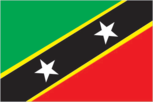
Flag description
divided diagonally from the lower hoist side by a broad black band bearing two white, five-pointed stars; the black band is edged in yellow; the upper triangle is green, the lower triangle is red; green signifies the island's fertility, red symbolizes the struggles of the people from slavery, yellow denotes year-round sunshine, and black represents the African heritage of the people; the white stars stand for the islands of Saint Kitts and Nevis, but can also express hope and liberty, or independence and optimism
Government type
parliamentary democracy and a Commonwealth realm
Independence
19 September 1983 (from the UK)
International organization participation
ACP, AOSIS, C, Caricom, CDB, FAO, G-77, IBRD, ICAO, ICCt, ICRM, IDA, IFAD, IFC, IFRCS, ILO, IMF, IMO, Interpol, IOC, ITU, MIGA, NAM, OAS, OECS, OPANAL, OPCW, PetroCaribe, UN, UNCTAD, UNESCO, UNIDO, UPU, WHO, WIPO, WTO
Judicial branch
Eastern Caribbean Supreme Court (consisting of a Court of Appeal and a High Court; based on Saint Lucia; two judges of the Supreme Court reside in Saint Kitts and Nevis); member of the Caribbean Court of Justice (CCJ)
Legal system
based on English common law; has not accepted compulsory ICJ jurisdiction
Legislative branch
- unicameral National Assembly (14 seats, 3 appointed and 11 popularly elected from single-member constituencies; members serve five-year terms)
- election results
- percent of vote by party - NA; seats by party - SKNLP 6, CCM 2, PAM 2, NRP 1
- elections
- last held on 25 January 2010 (next to be held by 2015)
National anthem
- lyrics/music
- Kenrick Anderson GEORGES note: adopted 1983
- name
- "Oh Land of Beauty!"
National holiday
Independence Day, 19 September (1983)
Political parties and leaders
Concerned Citizens Movement or CCM [Vance AMORY]; Nevis Reformation Party or NRP [Joseph PARRY]; People's Action Movement or PAM [Lindsay GRANT]; Saint Kitts and Nevis Labor Party or SKNLP [Dr. Denzil DOUGLAS]
Political pressure groups and leaders
NA
Suffrage
18 years of age; universal
Economy
Agriculture - products
sugarcane, rice, yams, vegetables, bananas; fish
Central bank discount rate
6.5% (31 December 2009) 6.5% (31 December 2008)
Commercial bank prime lending rate
8.75% (31 December 2009 est.) 8.75% (31 December 2008 est.)
Current account balance
-$163 million (2007 est.)
Debt - external
$314 million (2004)
Economy - overview
The economy of Saint Kitts and Nevis is heavily dependent upon tourism revenues, which has replaced sugar, the traditional mainstay of the economy until the 1970s. Following the 2005 harvest, the government closed the sugar industry after decades of losses of 3-4% of GDP annually. To compensate for employment losses, the government has embarked on a program to diversify the agricultural sector and to stimulate other sectors of the economy, such as tourism, export-oriented manufacturing, and offshore banking. More than 200,000 tourists visited the islands in 2009. Like other tourist destinations in the Caribbean, St. Kitts and Nevis is vulnerable to damage from natural disasters and shifts in tourism demand. The current government is constrained by one of the world's highest public debt burdens equivalent to roughly 185% of GDP, largely attributable to public enterprise losses.
Electricity - consumption
120.9 million kWh (2007 est.)
Electricity - exports
0 kWh (2008 est.)
Electricity - imports
0 kWh (2008 est.)
Electricity - production
130 million kWh (2007 est.)
Exchange rates
East Caribbean dollars (XCD) per US dollar - 2.7 (2007), 2.7 (2006), 2.7 (2005), 2.7 (2004), 2.7 (2003)
Exports
$84 million (2006)
Exports - commodities
machinery, food, electronics, beverages, tobacco
Exports - partners
US 62.3%, Canada 7.93%, Azerbaijan 6.72% (2009)
GDP - composition by sector
- agriculture
- 3.5%
- industry
- 25.8%
- services
- 70.7% (2001)
GDP - per capita (PPP)
$14,400 (2010 est.) $14,800 (2009 est.) $15,700 (2008 est.) note: data are in 2010 US dollars
GDP - real growth rate
-1.5% (2010 est.) -5.5% (2009 est.) 4.6% (2008 est.)
GDP (official exchange rate)
$562 million (2010 est.)
GDP (purchasing power parity)
$719.5 million (2010 est.) $730.5 million (2009 est.) $772.7 million (2008 est.) note: data are in 2010 US dollars
Household income or consumption by percentage share
lowest 10%: NA% highest 10%: NA%
Imports
$383 million (2006)
Imports - commodities
machinery, manufactures, food, fuels
Imports - partners
US 43.37%, Trinidad and Tobago 15.26%, Italy 11.83% (2009)
Industrial production growth rate
NA%
Industries
tourism, cotton, salt, copra, clothing, footwear, beverages
Inflation rate (consumer prices)
4.5% (2007 est.)
Labor force
18,170 (June 1995)
Market value of publicly traded shares
$648 million (31 December 2009) $595.2 million (31 December 2008) $439.7 million (31 December 2007)
Natural gas - consumption
0 cu m (2008 est.)
Natural gas - exports
0 cu m (2008 est.)
Natural gas - imports
0 cu m (2008 est.)
Natural gas - production
0 cu m (2008 est.)
Natural gas - proved reserves
0 cu m (1 January 2010 est.)
Oil - consumption
1,000 bbl/day (2009 est.)
Oil - exports
0 bbl/day (2007 est.)
Oil - imports
1,225 bbl/day (2007 est.)
Oil - production
0 bbl/day (2009 est.)
Oil - proved reserves
0 bbl (1 January 2010 est.)
Population below poverty line
NA%
Public debt
185% of GDP (2009 est.)
Stock of broad money
$823.8 million (31 December 2009) $787.8 million (31 December 2008)
Stock of domestic credit
$790.8 million (31 December 2008 est.) $782.4 million (31 December 2007 est.)
Stock of narrow money
$94.45 million (31 December 2009) $93.23 million (31 December 2008)
Unemployment rate
4.5% (1997)
Communications
Broadcast media
the government operates a national television network that broadcasts on 2 channels; cable subscription services provide access to local and international channels; the government operates a national radio network; a mix of government-owned and privately-owned broadcasters operate roughly 15 radio stations (2007)
Internet country code
.kn
Internet hosts
51 (2010)
Internet users
17,000 (2009)
Telephone system
- domestic
- interisland links via Eastern Caribbean Fiber Optic cable; construction of enhanced wireless infrastructure launched in November 2004
- general assessment
- good interisland and international connections
- international
- country code - 1-869; connected internationally by the East Caribbean Fiber Optic System (ECFS) and Southern Caribbean fiber optic system (SCF) submarine cables
Telephones - main lines in use
20,500 (2009)
Telephones - mobile cellular
83,000 (2009)
Transportation
Airports
2 (2010)
Airports - with paved runways
- total
- 2 1,524 to 2,437 m: 1 914 to 1,523 m: 1 (2010)
Merchant marine
- by type
- bulk carrier 20, cargo 92, chemical tanker 4, combination ore/oil 1, container 3, liquefied gas 4, passenger/cargo 5, petroleum tanker 24, refrigerated cargo 4, roll on/roll off 3
- foreign-owned
- 94 (Bahrain 1, Belgium 1, China 1, Estonia 3, Italy 1, Japan 3, Kuwait 3, Latvia 2, Malaysia 1, Norway 1, Pakistan 3, Russia 11, Singapore 5, Syria 5, Turkey 22, UAE 17, UK 2, Ukraine 10, US 1, Yemen 1) (2010)
- total
- 160
Ports and terminals
Basseterre, Charlestown
Railways
- narrow gauge
- 50 km 0.762-m gauge on Saint Kitts for tourists (2008)
- total
- 50 km
Roadways
- paved
- 163 km
- total
- 383 km
- unpaved
- 220 km (2002)
Military and Security
Manpower available for military service
males age 16-49: 13,510 females age 16-49: 13,075 (2010 est.)
Manpower fit for military service
males age 16-49: 10,736 females age 16-49: 10,913 (2010 est.)
Manpower reaching militarily significant age annually
- female
- 430 (2010 est.)
- male
- 402
Military branches
Royal Saint Kitts and Nevis Defense Force (includes Coast Guard), Royal Saint Kitts and Nevis Police Force; for national security, Saint Kitts and Nevis relies on the Regional Security System, headquartered in Barbados (2010)
Military expenditures
NA
Military service age and obligation
18 years of age for voluntary military service; no conscription (2010)
Transnational Issues
Disputes - international
joins other Caribbean states to counter Venezuela's claim that Aves Island sustains human habitation, a criterion under UNCLOS, which permits Venezuela to extend its EEZ/continental shelf over a large portion of the eastern Caribbean Sea
Illicit drugs
transshipment point for South American drugs destined for the US and Europe; some money-laundering activity page last updated on January 11, 2011 ======================================================================