2011 Edition
CIA World Factbook 2011 Archive (HTML)
Introduction
Background
In 1959, three years before independence from Belgium, the majority ethnic group, the Hutus, overthrew the ruling Tutsi king. Over the next several years, thousands of Tutsis were killed, and some 150,000 driven into exile in neighboring countries. The children of these exiles later formed a rebel group, the Rwandan Patriotic Front (RPF), and began a civil war in 1990. The war, along with several political and economic upheavals, exacerbated ethnic tensions, culminating in April 1994 in a state-orchestrated genocide, in which Rwandans killed up to a million of their fellow citizens, including approximately three-quarters of the Tutsi population. The genocide ended later that same year when the predominantly Tutsi RPF, operating out of Uganda and northern Rwanda, defeated the national army and Hutu militias, and established an RPF-led government of national unity. Approximately 2 million Hutu refugees - many fearing Tutsi retribution - fled to neighboring Burundi, Tanzania, Uganda, and Zaire. Since then, most of the refugees have returned to Rwanda, but several thousand remained in the neighboring Democratic Republic of the Congo (DRC; the former Zaire) and formed an extremist insurgency bent on retaking Rwanda, much as the RPF tried in 1990. Rwanda held its first local elections in 1999 and its first post-genocide presidential and legislative elections in 2003. Rwanda in 2009 staged a joint military operation with the Congolese Army in DRC to rout out the Hutu extremist insurgency there and Kigali and Kinshasa restored diplomatic relations. Rwanda also joined the Commonwealth in late 2009.
Geography
Area
- 26,338 sq km 24,668 sq km 1,670 sq km
- total
- 26,338 sq km
- water
- 1,670 sq km
Area - comparative
slightly smaller than Maryland
Climate
temperate; two rainy seasons (February to April, November to January); mild in mountains with frost and snow possible
Coastline
0 km (landlocked)
Elevation extremes
- Rusizi River 950 m Volcan Karisimbi 4,519 m
- highest point
- Volcan Karisimbi 4,519 m
- lowest point
- Rusizi River 950 m
Environment - current issues
deforestation results from uncontrolled cutting of trees for fuel; overgrazing; soil exhaustion; soil erosion; widespread poaching
Environment - international agreements
- Biodiversity, Climate Change, Climate Change-Kyoto Protocol, Desertification, Endangered Species, Hazardous Wastes, Ozone Layer Protection, Wetlands Law of the Sea
- party to
- Biodiversity, Climate Change, Climate Change-Kyoto Protocol, Desertification, Endangered Species, Hazardous Wastes, Ozone Layer Protection, Wetlands
- signed, but not ratified
- Law of the Sea
Freshwater withdrawal (domestic/industrial/agricultural)
- 0.15 cu km/yr (24%/8%/68%) 17 cu m/yr (2000)
- per capita
- 17 cu m/yr (2000)
- total
- 0.15 cu km/yr (24%/8%/68%)
Geographic coordinates
2 00 S, 30 00 E
Geography - note
landlocked; most of the country is savanna grassland with the population predominantly rural
Irrigated land
90 sq km (2008)
Land boundaries
- 893 km Burundi 290 km, Democratic Republic of the Congo 217 km, Tanzania 217 km, Uganda 169 km
- border countries
- Burundi 290 km, Democratic Republic of the Congo 217 km, Tanzania 217 km, Uganda 169 km
- total
- 893 km
Land use
- 45.56% 10.25% 44.19% (2005)
- arable land
- 45.56%
- other
- 44.19% (2005)
- permanent crops
- 10.25%
Location
Central Africa, east of Democratic Republic of the Congo
Map references
Africa
Maritime claims
none (landlocked)
Natural hazards
- periodic droughts; the volcanic Virunga mountains are in the northwest along the border with Democratic Republic of the Congo Visoke (elev. 3,711 m), located on the border with the Democratic Republic of the Congo, is the country's only historically active volcano
- volcanism
- Visoke (elev. 3,711 m), located on the border with the Democratic Republic of the Congo, is the country's only historically active volcano
Natural resources
gold, cassiterite (tin ore), wolframite (tungsten ore), methane, hydropower, arable land
Terrain
mostly grassy uplands and hills; relief is mountainous with altitude declining from west to east
Total renewable water resources
5.2 cu km (2003)
People and Society
Age structure
- 42.9% (male 2,454,924/female 2,418,504) 54.7% (male 3,097,956/female 3,123,910) 2.4% (male 110,218/female 164,913) (2011 est.)
- 0-14 years
- 42.9% (male 2,454,924/female 2,418,504)
- 15-64 years
- 54.7% (male 3,097,956/female 3,123,910)
- 65 years and over
- 2.4% (male 110,218/female 164,913) (2011 est.)
Birth rate
36.74 births/1,000 population (2011 est.)
Children under the age of 5 years underweight
18% (2005)
Death rate
9.88 deaths/1,000 population (July 2011 est.)
Drinking water source
- urban: 77% of population rural: 62% of population total: 65% of population urban: 23% of population rural: 38% of population total: 35% of population (2008)
- rural
- 38% of population
- total
- 35% of population (2008)
- urban
- 23% of population
Education expenditures
4.1% of GDP (2008)
Ethnic groups
Hutu (Bantu) 84%, Tutsi (Hamitic) 15%, Twa (Pygmy) 1%
Health expenditures
9% of GDP (2009)
HIV/AIDS - adult prevalence rate
2.9% (2009 est.)
HIV/AIDS - deaths
4,100 (2009 est.)
HIV/AIDS - people living with HIV/AIDS
170,000 (2009 est.)
Hospital bed density
1.6 beds/1,000 population (2007)
Infant mortality rate
- 64.04 deaths/1,000 live births 67.64 deaths/1,000 live births 60.32 deaths/1,000 live births (2011 est.)
- female
- 60.32 deaths/1,000 live births (2011 est.)
- total
- 64.04 deaths/1,000 live births
Languages
Kinyarwanda (official, universal Bantu vernacular), French (official), English (official), Kiswahili (Swahili, used in commercial centers)
Life expectancy at birth
- 58.02 years 56.57 years 59.52 years (2011 est.)
- female
- 59.52 years (2011 est.)
- total population
- 58.02 years
Literacy
- age 15 and over can read and write 70.4% 76.3% 64.7% (2003 est.)
- definition
- age 15 and over can read and write
- female
- 64.7% (2003 est.)
- male
- 76.3%
- total population
- 70.4%
Major cities - population
KIGALI (capital) 909,000 (2009)
Major infectious diseases
- very high bacterial diarrhea, hepatitis A, and typhoid fever malaria rabies (2009)
- animal contact disease
- rabies (2009)
- degree of risk
- very high
- food or waterborne diseases
- bacterial diarrhea, hepatitis A, and typhoid fever
- vectorborne disease
- malaria
Maternal mortality rate
540 deaths/100,000 live births (2008)
Median age
- 18.7 years 18.5 years 19 years (2011 est.)
- female
- 19 years (2011 est.)
- male
- 18.5 years
- total
- 18.7 years
Nationality
- Rwandan(s) Rwandan
- adjective
- Rwandan
- noun
- Rwandan(s)
Net migration rate
1.06 migrant(s)/1,000 population (2011 est.)
People - note
Rwanda is the most densely populated country in Africa
Physicians density
0.024 physicians/1,000 population (2005)
Population
11,370,425 (July 2011 est.) estimates for this country explicitly take into account the effects of excess mortality due to AIDS; this can result in lower life expectancy, higher infant mortality, higher death rates, lower population growth rates, and changes in the distribution of population by age and sex than would otherwise be expected
Population growth rate
2.792% (2011 est.)
Religions
Roman Catholic 56.5%, Protestant 26%, Adventist 11.1%, Muslim 4.6%, indigenous beliefs 0.1%, none 1.7% (2001)
Sanitation facility access
- urban: 50% of population rural: 55% of population total: 54% of population urban: 50% of population rural: 45% of population total: 46% of population (2008)
- rural
- 45% of population
- total
- 46% of population (2008)
- urban
- 50% of population
School life expectancy (primary to tertiary education)
- 11 years 11 years 11 years (2009)
- female
- 11 years (2009)
- male
- 11 years
- total
- 11 years
Sex ratio
- 1.03 male(s)/female 1.01 male(s)/female 0.99 male(s)/female 0.67 male(s)/female 0.99 male(s)/female (2011 est.)
- 15-64 years
- 0.99 male(s)/female
- 65 years and over
- 0.67 male(s)/female
- at birth
- 1.03 male(s)/female
- total population
- 0.99 male(s)/female (2011 est.)
- under 15 years
- 1.01 male(s)/female
Total fertility rate
4.9 children born/woman (2011 est.)
Urbanization
- 19% of total population (2010) 4.4% annual rate of change (2010-15 est.)
- rate of urbanization
- 4.4% annual rate of change (2010-15 est.)
- urban population
- 19% of total population (2010)
Government
Administrative divisions
4 provinces (in French - provinces, singular - province; in Kinyarwanda - intara for singular and plural) and 1 city* (in French - ville; in Kinyarwanda - umujyi); Est (Eastern), Kigali*, Nord (Northern), Ouest (Western), Sud (Southern)
Capital
- Kigali 1 57 S, 30 04 E UTC+2 (7 hours ahead of Washington, DC during Standard Time)
- geographic coordinates
- 1 57 S, 30 04 E
- name
- Kigali
- time difference
- UTC+2 (7 hours ahead of Washington, DC during Standard Time)
Constitution
new constitution passed by referendum 26 May 2003
Country name
- Republic of Rwanda Rwanda Republika y'u Rwanda Rwanda Ruanda, German East Africa
- conventional long form
- Republic of Rwanda
- conventional short form
- Rwanda
- former
- Ruanda, German East Africa
- local long form
- Republika y'u Rwanda
- local short form
- Rwanda
Diplomatic representation from the US
- Ambassador Donald W. KORAN 2657 Avenue de la Gendarmerie, Kigali B. P. 28, Kigali [250] 596-400 [250] 596-591
- chief of mission
- Ambassador Donald W. KORAN
- embassy
- 2657 Avenue de la Gendarmerie, Kigali
- FAX
- [250] 596-591
- mailing address
- B. P. 28, Kigali
- telephone
- [250] 596-400
Diplomatic representation in the US
- Ambassador James KIMONYO 1714 New Hampshire Avenue NW, Washington, DC 20009 [1] (202) 232-2882 [1] (202) 232-4544
- chancery
- 1714 New Hampshire Avenue NW, Washington, DC 20009
- chief of mission
- Ambassador James KIMONYO
- FAX
- [1] (202) 232-4544
- telephone
- [1] (202) 232-2882
Executive branch
- President Paul KAGAME (since 22 April 2000) Prime Minister Pierre Damien HABUMUREMYI (since 7 October 2011) Council of Ministers appointed by the president President elected by popular vote for a seven-year term (eligible for a second term); elections last held on 9 August 2010 (next to be held in 2017) Paul KAGAME elected to a second term as president; Paul KAGAME 93.1%, Jean NTAWUKURIRYAYO 5.1%, Prosper HIGIRO 1.4%, Alvera MUKABAR 0.4%
- cabinet
- Council of Ministers appointed by the president
- chief of state
- President Paul KAGAME (since 22 April 2000)
- election results
- Paul KAGAME elected to a second term as president; Paul KAGAME 93.1%, Jean NTAWUKURIRYAYO 5.1%, Prosper HIGIRO 1.4%, Alvera MUKABAR 0.4%
- elections
- President elected by popular vote for a seven-year term (eligible for a second term); elections last held on 9 August 2010 (next to be held in 2017)
- head of government
- Prime Minister Pierre Damien HABUMUREMYI (since 7 October 2011)
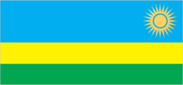
Flag description
three horizontal bands of sky blue (top, double width), yellow, and green, with a golden sun with 24 rays near the fly end of the blue band; blue represents happiness and peace, yellow economic development and mineral wealth, green hope of prosperity and natural resources; the sun symbolizes unity, as well as enlightenment and transparency from ignorance
Government type
republic; presidential, multiparty system
Independence
1 July 1962 (from Belgium-administered UN trusteeship)
International law organization participation
has not submitted an ICJ jurisdiction declaration; non-party state to the ICCt
International organization participation
ACP, AfDB, AU, C, CEPGL, COMESA, EAC, EADB, FAO, G-77, IAEA, IBRD, ICAO, ICRM, IDA, IFAD, IFC, IFRCS, ILO, IMF, Interpol, IOC, IOM, IPU, ISO (correspondent), ITSO, ITU, ITUC, MIGA, NAM, OIF, OPCW, UN, UNAMID, UNCTAD, UNESCO, UNIDO, UNISFA, UNMISS, UNWTO, UPU, WCO, WHO, WIPO, WMO, WTO
Judicial branch
Supreme Court; High Courts of the Republic; Provincial Courts; District Courts; mediation committees
Legal system
mixed legal system of civil law, based on German and Belgian models, and customary law; judicial review of legislative acts in the Supreme Court
Legislative branch
- bicameral Parliament consists of Senate (26 seats; 12 members elected by local councils, 8 appointed by the president, 4 appointed by the Political Organizations Forum, 2 represent institutions of higher learning; members to serve eight-year terms) and Chamber of Deputies (80 seats; 53 members elected by popular vote, 24 women elected by local bodies, 3 selected by youth and disability organizations; members to serve five-year terms) Senate - NA; Chamber of Deputies - last held on 15 September 2008 (next to be held in September 2013) percent of vote by party - RPF 78.8%, PSD 13.1%, PL 7.5%; seats by party - RPF 42, PSD 7, PL 4, additional 27 members indirectly elected
- election results
- percent of vote by party - RPF 78.8%, PSD 13.1%, PL 7.5%; seats by party - RPF 42, PSD 7, PL 4, additional 27 members indirectly elected
- elections
- Senate - NA; Chamber of Deputies - last held on 15 September 2008 (next to be held in September 2013)
National anthem
- "Rwanda nziza" (Rwanda, Our Beautiful Country) Faustin MURIGO/Jean-Bosco HASHAKAIMANA adopted 2001
- lyrics/music
- Faustin MURIGO/Jean-Bosco HASHAKAIMANA
- name
- "Rwanda nziza" (Rwanda, Our Beautiful Country)
National holiday
Independence Day, 1 July (1962)
Political parties and leaders
Centrist Democratic Party or PDC [Agnes MUKABARANGA]; Democratic Popular Union of Rwanda or UDPR [Gonzague RWIGEMA]; Democratic Republican Movement or MDR [Celestin KABANDA] (officially banned); Islamic Democratic Party or PDI [Musa Fazil HARERIMANA]; Liberal Party or PL [Protais MITALI]; Party for Democratic Renewal (officially banned); Party for Progress and Concord or PPC [Alvera MUKABARAMBA]; Rwandan Patriotic Front or RPF [Paul KAGAME]; Rwandan Socialist Party or PSR [Jean Baptist RUCIBIGANGO]; Social Democratic Party or PSD [Vincent BIRUTA]; Socialist Party-Imberakuri or PS-Imberakuri [Christine MUKABUNANI]; Solidarity and Prosperity Party or PSP [Pheobe KANYANGE]
Political pressure groups and leaders
IBUKA (association of genocide survivors)
Suffrage
18 years of age; universal
Economy
Agriculture - products
coffee, tea, pyrethrum (insecticide made from chrysanthemums), bananas, beans, sorghum, potatoes; livestock
Budget
- $1.449 billion $1.471 billion (2010 est.)
- expenditures
- $1.471 billion (2010 est.)
- revenues
- $1.449 billion
Budget surplus (+) or deficit (-)
-0.4% of GDP (2010 est.)
Central bank discount rate
7.75% (31 December 2010 est.) 11.25% (31 December 2008)
Commercial bank prime lending rate
16% (31 December 2010 est.) 16% (31 December 2009 est.)
Current account balance
-$629.3 million (2010 est.) -$379 million (2009 est.)
Debt - external
$NA (31 December 2010 est.) $747 million (31 December 2009 est.)
Distribution of family income - Gini index
46.8 (2000) 28.9 (1985)
Economy - overview
Rwanda is a poor rural country with about 90% of the population engaged in (mainly subsistence) agriculture and some mineral and agro-processing. Tourism is now Rwanda's primary foreign exchange earner and in 2008, minerals overtook coffee and tea as Rwanda's primary export. Minerals exports declined 40% in 2009-10 due to the global economic downturn. The 1994 genocide decimated Rwanda's fragile economic base, severely impoverished the population, particularly women, and temporarily stalled the country's ability to attract private and external investment. However, Rwanda has made substantial progress in stabilizing and rehabilitating its economy to pre-1994 levels. GDP has rebounded with an average annual growth of 7-8% since 2003 and inflation has been reduced to single digits. Nonetheless, a significant percent of the population still live below the official poverty line. Despite Rwanda's fertile ecosystem, food production often does not keep pace with demand, requiring food imports. Agricultural production has increased significantly over the last three years and last year Rwanda was self sufficient in food production. Rwanda continues to receive substantial aid money and obtained IMF-World Bank Heavily Indebted Poor Country (HIPC) initiative debt relief in 2005-06. In recognition of Rwanda's successful management of its macro economy, in 2010, the IMF graduated Rwanda to a Policy Support Instrument (PSI). Rwanda also received a Millennium Challenge Threshold Program in 2008. Africa's most densely populated country is trying to overcome the limitations of its small, landlocked economy by leveraging regional trade. Rwanda joined the East African Community and is aligning its budget, trade, and immigration policies with its regional partners. The government has embraced an expansionary fiscal policy to reduce poverty by improving education, infrastructure, and foreign and domestic investment and pursuing market-oriented reforms. Energy shortages, instability in neighboring states, and lack of adequate transportation linkages to other countries continue to handicap private sector growth. The Rwandan government is seeking to become regional leader in information and communication technologies. In 2010, Rwanda neared completion of the first modern Special Economic Zone (SEZ) in Kigali. The SEZ seeks to attract investment in all sectors, but specifically in agribusiness, information and communications technologies, trade and logistics, mining, and construction. The global downturn hurt export demand and tourism, but economic growth is recovering, driven in large part by the services sector, and inflation has been contained. On the back of this growth, government is gradually ending its fiscal stimulus policy while protecting aid to the poor.
Electricity - consumption
236.8 million kWh (2008 est.)
Electricity - exports
2 million kWh (2008 est.)
Electricity - imports
88 million kWh (2008 est.)
Electricity - production
160 million kWh (2008 est.)
Exchange rates
Rwandan francs (RWF) per US dollar - 586.25 (2010) 568.18 (2009) 550 (2008) 585 (2007) 560 (2006)
Exports
$234.2 million (2010 est.) $193 million (2009 est.)
Exports - commodities
coffee, tea, hides, tin ore
Exports - partners
Kenya 36.6%, Democratic Republic of the Congo 14.7%, China 9.1%, Swaziland 5.9%, US 5.3%, Pakistan 4.6% (2010)
GDP - composition by sector
- 33.6% 14.3% 52.1% (2010 est.)
- agriculture
- 33.6%
- industry
- 14.3%
- services
- 52.1% (2010 est.)
GDP - per capita (PPP)
$1,100 (2010 est.) $1,100 (2009 est.) $1,100 (2008 est.) data are in 2010 US dollars
GDP - real growth rate
6.5% (2010 est.) 4.1% (2009 est.) 11.2% (2008 est.)
GDP (official exchange rate)
$5.622 billion (2010 est.)
GDP (purchasing power parity)
$12.16 billion (2010 est.) $11.42 billion (2009 est.) $10.97 billion (2008 est.) data are in 2010 US dollars
Household income or consumption by percentage share
- 2.1% 38.2% (2000)
- highest 10%
- 38.2% (2000)
- lowest 10%
- 2.1%
Imports
$1.121 billion (2010 est.) $961 million (2009 est.)
Imports - commodities
foodstuffs, machinery and equipment, steel, petroleum products, cement and construction material
Imports - partners
Kenya 19.6%, Uganda 17.7%, UAE 8.4%, Tanzania 5.7%, China 5.3% (2010)
Industrial production growth rate
7.5% (2010 est.)
Industries
cement, agricultural products, small-scale beverages, soap, furniture, shoes, plastic goods, textiles, cigarettes
Inflation rate (consumer prices)
2.3% (2010 est.) 10.4% (2009 est.)
Investment (gross fixed)
22.1% of GDP (2010 est.)
Labor force
4.446 million (2007)
Labor force - by occupation
- 90% 10% (2000)
- agriculture
- 90%
- industry and services
- 10% (2000)
Market value of publicly traded shares
$NA
Natural gas - consumption
0 cu m (2009 est.)
Natural gas - exports
0 cu m (2009 est.)
Natural gas - imports
0 cu m (2009 est.)
Natural gas - production
0 cu m (2009 est.)
Natural gas - proved reserves
56.63 billion cu m (1 January 2011 est.)
Oil - consumption
6,000 bbl/day (2010 est.)
Oil - exports
0 bbl/day (2009 est.)
Oil - imports
5,105 bbl/day (2009 est.)
Oil - production
0 bbl/day (2010 est.)
Oil - proved reserves
0 bbl (1 January 2011 est.)
Population below poverty line
60% (2001 est.)
Reserves of foreign exchange and gold
$812.8 million (31 December 2010 est.) $742.7 million (31 December 2009 est.)
Stock of broad money
$1.243 billion (31 December 2010 est.) $1.068 billion (31 December 2009 est.)
Stock of domestic credit
$538.1 million (31 December 2010 est.) $490.9 million (31 December 2009 est.)
Stock of narrow money
$540.2 million (31 December 2010 est.) $512.7 million (31 December 2009 est.)
Taxes and other revenues
25.8% of GDP (2010 est.)
Unemployment rate
NA%
Communications
Broadcast media
government owns and operates the only TV station; government-owned and operated Radio Rwanda has a national reach; 9 private radio stations; transmissions of multiple international broadcasters are available (2007)
Internet country code
.rw
Internet hosts
815 (2010)
Internet users
450,000 (2009)
Telephone system
- small, inadequate telephone system primarily serves business, education, and government the capital, Kigali, is connected to the centers of the provinces by microwave radio relay and, recently, by cellular telephone service; much of the network depends on wire and HF radiotelephone; combined fixed-line and mobile-cellular telephone density has increased to about 25 telephones per 100 persons country code - 250; international connections employ microwave radio relay to neighboring countries and satellite communications to more distant countries; satellite earth stations - 1 Intelsat (Indian Ocean) in Kigali (includes telex and telefax service)
- domestic
- the capital, Kigali, is connected to the centers of the provinces by microwave radio relay and, recently, by cellular telephone service; much of the network depends on wire and HF radiotelephone; combined fixed-line and mobile-cellular telephone density has increased to about 25 telephones per 100 persons
- general assessment
- small, inadequate telephone system primarily serves business, education, and government
- international
- country code - 250; international connections employ microwave radio relay to neighboring countries and satellite communications to more distant countries; satellite earth stations - 1 Intelsat (Indian Ocean) in Kigali (includes telex and telefax service)
Telephones - main lines in use
39,700 (2010)
Telephones - mobile cellular
3.549 million (2010)
Transportation
Airports
9 (2010)
Airports - with paved runways
- 1 (2010)
- 914 to 1,523 m
- 2
- over 3,047 m
- 1
- total
- 4
- under 914 m
- 1 (2010)
Airports - with unpaved runways
- 3 (2010)
- 914 to 1,523 m
- 2
- total
- 5
- under 914 m
- 3 (2010)
Ports and terminals
Cyangugu, Gisenyi, Kibuye
Roadways
- 14,008 km 2,662 km 11,346 km (2004)
- total
- 14,008 km
- unpaved
- 11,346 km (2004)
Waterways
(Lac Kivu navigable by shallow-draft barges and native craft) (2009)
Military and Security
Manpower available for military service
- 2,625,917 2,608,110 (2010 est.)
- females age 16-49
- 2,608,110 (2010 est.)
- males age 16-49
- 2,625,917
Manpower fit for military service
- 1,685,066 1,749,580 (2010 est.)
- females age 16-49
- 1,749,580 (2010 est.)
- males age 16-49
- 1,685,066
Manpower reaching militarily significant age annually
- 110,736 110,328 (2010 est.)
- female
- 110,328 (2010 est.)
- male
- 110,736
Military branches
- Rwandan Defense Force (RDF): Rwandan Army (Rwandan Land Force), Rwandan Air Force (2011)
- Rwandan Defense Force (RDF)
- Rwandan Army (Rwandan Land Force), Rwandan Air Force (2011)
Military expenditures
2.9% of GDP (2006 est.)
Military service age and obligation
18 years of age for voluntary military service; no conscription; Rwandan citizenship required (2011)
Transnational Issues
Disputes - international
Burundi and Rwanda dispute two sq km (0.8 sq mi) of Sabanerwa, a farmed area in the Rukurazi Valley where the Akanyaru/Kanyaru River shifted its course southward after heavy rains in 1965; fighting among ethnic groups - loosely associated political rebels, armed gangs, and various government forces in Great Lakes region transcending the boundaries of Burundi, Democratic Republic of the Congo, Rwanda, and Uganda - abated substantially from a decade ago due largely to UN peacekeeping, international mediation, and efforts by local governments to create civil societies; nonetheless, 57,000 Rwandan refugees still reside in 21 African states, including Zambia, Gabon, and 20,000 who fled to Burundi in 2005 and 2006 to escape drought and recriminations from traditional courts investigating the 1994 massacres; the 2005 DROC and Rwanda border verification mechanism to stem rebel actions on both sides of the border remains in place
Refugees and internally displaced persons
- 46,272 (Democratic Republic of the Congo); 4,400 (Burundi) (2007)
- refugees (country of origin)
- 46,272 (Democratic Republic of the Congo); 4,400 (Burundi) (2007)