2003 Edition
CIA World Factbook 2003 (Project Gutenberg)
Introduction
Administrative divisions
none (overseas territory of the UK)
Age structure
0-14 years: NA% 15-64 years: NA% 65 years and over: NA% (2003 est.)
Agriculture - products
wide variety of fruits and vegetables, goats, chickens
Airports
none (2002) Military Pitcairn Islands
Area
- land
- 47 sq km
- total
- 47 sq km
- water
- 0 sq km
Area - comparative
about 0.3 times the size of Washington, DC
Background
Pitcairn Island was discovered in 1767 by the British and settled in 1790 by the Bounty mutineers and their Tahitian companions. Pitcairn was the first Pacific island to become a British colony (in 1838) and today remains the last vestige of that empire in the South Pacific. Outmigration, primarily to New Zealand, has thinned the population from a peak of 233 in 1937 to less than 50 today. Geography Pitcairn Islands
Birth rate
NA births/1,000 population (2003 est.)
Budget
- expenditures
- $878,119, including capital expenditures of $NA (FY 94/95 est.)
- revenues
- $729,884
Capital
Adamstown
Climate
tropical, hot, humid; modified by southeast trade winds; rainy season (November to March)
Coastline
51 km
Constitution
1838; reformed 1904 with additional reforms in 1940; further refined by the Local Government Ordinance of 1964
Country name
- conventional long form
- Pitcairn, Henderson, Ducie, and Oeno Islands
- conventional short form
- Pitcairn Islands
Currency
New Zealand dollar (NZD)
Currency code
NZD
Death rate
NA deaths/1,000 population (2003 est.)
Debt - external
$NA
Dependency status
overseas territory of the UK
Diplomatic representation from the US
none (overseas territory of the UK)
Diplomatic representation in the US
none (overseas territory of the UK)
Disputes - international
none This page was last updated on 18 December, 2003
Economic aid - recipient
$NA
Economy - overview
The inhabitants of this tiny isolated economy exist on fishing, subsistence farming, handicrafts, and postage stamps. The fertile soil of the valleys produces a wide variety of fruits and vegetables, including citrus, sugarcane, watermelons, bananas, yams, and beans. Bartering is an important part of the economy. The major sources of revenue are the sale of postage stamps to collectors and the sale of handicrafts to passing ships.
Electricity - consumption
NA kWh
Electricity - production
NA kWh; note - electric power is provided by a small diesel-powered generator
Elevation extremes
- highest point
- Pawala Valley Ridge 347 m
- lowest point
- Pacific Ocean 0 m
Environment - current issues
deforestation (only a small portion of the original forest remains because of burning and clearing for settlement)
Ethnic groups
descendants of the Bounty mutineers and their Tahitian wives
Exchange rates
New Zealand dollars per US dollar - 2.162 (2002), 2.3776 (2001), 2.1863 (2000), 1.8886 (1999), 1.8629 (1998), 1.5083 (1997)
Executive branch
- cabinet
- NA
- chief of state
- Queen ELIZABETH II (since 6 February 1952), represented by UK High Commissioner to New Zealand and Governor (nonresident) of the Pitcairn Islands Richard FELL (since NA December 2001); Commissioner (nonresident) Leon SALT (since NA); serves as liaison between the governor and the Island Council
- election results
- Steve CHRISTIAN elected mayor; percent of vote - NA%
- elections
- the monarchy is hereditary; high commissioner and commissioner appointed by the monarch; island magistrate elected by popular vote for a three-year term; election last held NA December 1999 (next to be held NA December 2002)
- head of government
- Mayor and Chairman of the Island Council Steve CHRISTIAN (since 7 December 1999)
Exports
$NA
Exports - commodities
fruits, vegetables, curios, stamps
Exports - partners
NA (2000)
Fiscal year
1 April - 31 March Communications Pitcairn Islands
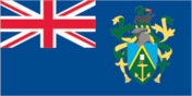
Flag description
blue with the flag of the UK in the upper hoist-side quadrant and the Pitcairn Islander coat of arms centered on the outer half of the flag; the coat of arms is yellow, green, and light blue with a shield featuring a yellow anchor Economy Pitcairn Islands
GDP
purchasing power parity - $NA
GDP - composition by sector
- agriculture
- NA%
- industry
- NA%
- services
- NA%
GDP - per capita
purchasing power parity - $NA
GDP - real growth rate
NA%
Geographic coordinates
25 04 S, 130 06 W
Geography - note
Britain's most isolated dependency; only the larger island of Pitcairn is inhabited but it has no port or natural harbor; supplies must be transported by rowed longboat from larger ships stationed offshore People Pitcairn Islands
Government type
NA
Highways
- paved
- 0 km
- total
- 6.4 km
- unpaved
- 6.4 km
HIV/AIDS - adult prevalence rate
NA%
HIV/AIDS - deaths
NA
HIV/AIDS - people living with HIV/AIDS
NA
Household income or consumption by percentage share
- highest 10%
- NA%
- lowest 10%
- NA%
Imports
$NA
Imports - commodities
fuel oil, machinery, building materials, flour, sugar, other foodstuffs
Imports - partners
NA (2000)
Independence
none (overseas territory of the UK)
Industrial production growth rate
NA%
Industries
postage stamps, handicrafts
Infant mortality rate
- female
- NA%
- male
- NA%
- total
- NA%
Inflation rate (consumer prices)
NA%
International organization participation
SPC
Internet country code
.pn
Internet Service Providers (ISPs)
NA
Internet users
NA Transportation Pitcairn Islands
Irrigated land
NA sq km
Judicial branch
Island Court (island magistrate presides over the court and is elected every three years)
Labor force
12 able-bodied men (1997)
Labor force - by occupation
no business community in the usual sense; some public works; subsistence farming and fishing
Land boundaries
0 km
Land use
- arable land
- NA%
- other
- NA% (1998 est.)
- permanent crops
- NA%
Languages
English (official), Pitcairnese (mixture of an 18th century English dialect and a Tahitian dialect)
Legal system
local island by-laws
Legislative branch
- unicameral Island Council (10 seats - 6 elected by popular vote, 1 appointed by the 6 elected members, 2 appointed by the governor, and 1 seat for the Island Secretary; members serve one-year terms)
- election results
- percent of vote - NA%; seats - all independents
- elections
- last held NA December 2002 (next to be held NA December 2003)
Life expectancy at birth
- female
- NA years (2003 est.)
- male
- NA years
- total population
- NA years
Literacy
NA Government Pitcairn Islands
Location
Oceania, islands in the South Pacific Ocean, about midway between Peru and New Zealand
Map references
Oceania
Maritime claims
- exclusive economic zone
- 200 NM
- territorial sea
- 3 NM
Merchant marine
none (2002 est.)
Military - note
defense is the responsibility of the UK Transnational Issues Pitcairn Islands
National holiday
Birthday of Queen ELIZABETH II, second Saturday in June (1926)
Nationality
- adjective
- Pitcairn Islander
- noun
- Pitcairn Islander(s)
Natural hazards
typhoons (especially November to March)
Natural resources
- miro trees (used for handicrafts), fish
- note
- manganese, iron, copper, gold, silver, and zinc have been discovered offshore
Net migration rate
NA migrant(s)/1,000 population (2003 est.)
Political parties and leaders
none
Political pressure groups and leaders
none
Population
47 (July 2003 est.)
Population below poverty line
NA%
Population growth rate
NA%
Ports and harbors
Adamstown (on Bounty Bay)
Radio broadcast stations
AM 1, FM 0, shortwave 0 (1998)
Radios
NA
Railways
0 km
Religions
Seventh-Day Adventist 100%
Sex ratio
NA (2003 est.)
Suffrage
18 years of age; universal with three years residency
Telephone system
- domestic
- party line service only
- general assessment
- only party line telephone service is available for this small, closely related community
- international
- radiotelephone
Telephones - main lines in use
1 (there are 17 telephones on one party line) (1997)
Television broadcast stations
0 (1997)
Televisions
NA
Terrain
rugged volcanic formation; rocky coastline with cliffs
Total fertility rate
NA children born/woman (2003 est.)
Unemployment rate
NA%
Waterways
none