1993 Edition
CIA World Factbook 1993 (Project Gutenberg)
Geography
Area
total area: 47 km2 land area: 47 km2 comparative area: about 0.3 times the size of Washington, DC
Climate
tropical, hot, humid, modified by southeast trade winds; rainy season (November to March)
Coastline
51 km
Environment
subject to typhoons (especially November to March)
International disputes
none
Irrigated land
NA km2
Land boundaries
0 km
Land use
arable land: NA% permanent crops: NA% meadows and pastures: NA% forest and woodland: NA% other: NA%
Location
in the South Pacific Ocean, about halfway between Peru and New Zealand
Map references
Oceania
Maritime claims
exclusive fishing zone: 200 nm territorial sea: 3 nm
Natural resources
miro trees (used for handicrafts), fish
Terrain
rugged volcanic formation; rocky coastline with cliffs
People and Society
Birth rate
NA births/1,000 population
Death rate
NA deaths/1,000 population
Ethnic divisions
descendants of the Bounty mutineers
Infant mortality rate
NA deaths/1,000 live births
Labor force
NA by occupation: no business community in the usual sense; some public works; subsistence farming and fishing
Languages
English (official), Tahitian/English dialect
Life expectancy at birth
total population: NA years male: NA years female: NA years
Literacy
total population: NA% male: NA% female: NA%
Nationality
noun: Pitcairn Islander(s) adjective: Pitcairn Islander
Net migration rate
NA migrant(s)/1,000 population
Population
52 (July 1993 est.)
Population growth rate
0% (1993 est.)
Religions
Seventh-Day Adventist 100%
Total fertility rate
NA children born/woman
Government
Administrative divisions
none (dependent territory of the UK)
Capital
Adamstown
Constitution
Local Government Ordinance of 1964
Digraph
PC
Diplomatic representation in US
none (dependent territory of the UK)
Executive branch
British monarch, governor, island magistrate
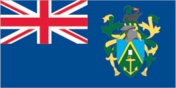
Flag
blue with the flag of the UK in the upper hoist-side quadrant and the Pitcairn Islander coat of arms centered on the outer half of the flag; the coat of arms is yellow, green, and light blue with a shield featuring a yellow anchor
Head of Government
Island Magistrate and Chairman of the Island Council Jay WARREN (since NA)
Independence
none (dependent territory of the UK)
Island Council
last held NA (next to be held NA); results - percent of vote by party NA; seats - (11 total, 5 elected) number of seats by party NA
Judicial branch
Island Court
Leaders
Chief of State: Queen ELIZABETH II (since 6 February 1952), represented by the Governor and UK High Commissioner to New Zealand David Joseph MOSS (since NA 1990)
Legal system
local island by-laws
Legislative branch
unicameral Island Council
Member of
SPC
Names
conventional long form: Pitcairn, Henderson, Ducie, and Oeno Islands conventional short form: Pitcairn Islands
National holiday
Celebration of the Birthday of the Queen, 10 June (1989) (second Saturday in June)
Other political or pressure groups
NA
Political parties and leaders
NA
Suffrage
18 years of age; universal with three years residency
Type
dependent territory of the UK
US diplomatic representation
none (dependent territory of the UK)
Economy
Agriculture
based on subsistence fishing and farming; wide variety of fruits and vegetables grown; must import grain products
Budget
revenues $430,440; expenditures $429,983, including capital expenditures of $NA (FY87 est.)
Currency
1 New Zealand dollar (NZ$) = 100 cents
Economic aid
none
Electricity
110 kW capacity; 0.30 million kWh produced, 5,360 kWh per capita (1990)
Exchange rates
New Zealand dollars (NZ$) per US$1 - 1.9486 (January 1993), 1.8584 (1992), 1.7265 (1991), 1.6750 (1990), 1.6711 (1989), 1.5244 (1988)
Exports
$NA commodities: fruits, vegetables, curios partners: NA
External debt
$NA
Fiscal year
1 April - 31 March
Imports
$NA commodities: fuel oil, machinery, building materials, flour, sugar, other foodstuffs partners: NA
Industrial production
growth rate NA%
Industries
postage stamp sales, handicrafts
Inflation rate (consumer prices)
NA%
National product
GDP $NA
National product per capita
$NA
National product real growth rate
NA%
Overview
The inhabitants exist on fishing and subsistence farming. The fertile soil of the valleys produces a wide variety of fruits and vegetables, including citrus, sugarcane, watermelons, bananas, yams, and beans. Bartering is an important part of the economy. The major sources of revenue are the sale of postage stamps to collectors and the sale of handicrafts to passing ships.
Unemployment rate
NA%
Communications
Airports
none
Highways
6.4 km dirt roads
Ports
Bounty Bay
Railroads
none
Telecommunications
24 telephones; party line telephone service on the island; broadcast stations - 1 AM, no FM, no TV; diesel generator provides electricity
Military and Security
Note
defense is the responsibility of the UK