2007 Edition
CIA World Factbook 2007 (Project Gutenberg)
Introduction
Administrative divisions
25 regions (regiones, singular - region) and 1 province* (provincia); Amazonas, Ancash, Apurimac, Arequipa, Ayacucho, Cajamarca, Callao, Cusco, Huancavelica, Huanuco, Ica, Junin, La Libertad, Lambayeque, Lima, Lima*, Loreto, Madre de Dios, Moquegua, Pasco, Piura, Puno, San Martin, Tacna, Tumbes, Ucayali
Age structure
0-14 years: 30.9% (male 4,456,195/female 4,300,233) 15-64 years: 63.7% (male 9,078,123/female 8,961,981) 65 years and over: 5.3% (male 709,763/female 796,308) (2006 est.)
Agriculture - products
asparagus, coffee, cotton, sugarcane, rice, potatoes, corn, plantains, grapes, oranges, coca; poultry, beef, dairy products; fish, guinea pigs
Airports
268 (2006)
Airports - with paved runways
- over 3,047 m
- 6 2,438 to 3,047 m: 20 1,524 to 2,437 m: 14 914 to 1,523 m: 11
- total
- 54
- under 914 m
- 3 (2006)
Airports - with unpaved runways
- total
- 214 2,438 to 3,047 m: 1 1,524 to 2,437 m: 26 914 to 1,523 m: 63
- under 914 m
- 124 (2006)
Area
- land
- 1.28 million sq km
- total
- 1,285,220 sq km
- water
- 5,220 sq km
Area - comparative
slightly smaller than Alaska
Background
Ancient Peru was the seat of several prominent Andean civilizations, most notably that of the Incas whose empire was captured by the Spanish conquistadors in 1533. Peruvian independence was declared in 1821, and remaining Spanish forces defeated in 1824. After a dozen years of military rule, Peru returned to democratic leadership in 1980, but experienced economic problems and the growth of a violent insurgency. President Alberto FUJIMORI's election in 1990 ushered in a decade that saw a dramatic turnaround in the economy and significant progress in curtailing guerrilla activity. Nevertheless, the president's increasing reliance on authoritarian measures and an economic slump in the late 1990s generated mounting dissatisfaction with his regime, which led to his ouster in 2000. A caretaker government oversaw new elections in the spring of 2001, which ushered in Alejandro TOLEDO as the new head of government - Peru's first democratically elected president of Native American ethnicity. The presidential election of 2006 saw the return of Alan GARCIA who, after a disappointing presidential term from 1985 to 1990, returned to the presidency with promises to improve social conditions and maintain fiscal responsibility. Geography Peru
Birth rate
20.48 births/1,000 population (2006 est.)
Budget
- expenditures
- $25.18 billion; including capital expenditures of $1.8 billion for general government, but excluding private enterprises (2006 est.)
- revenues
- $25.5 billion
Capital
- geographic coordinates
- 12 03 S, 77 03 W
- name
- Lima
- time difference
- UTC-5 (same time as Washington, DC during Standard Time)
Climate
varies from tropical in east to dry desert in west; temperate to frigid in Andes
Coastline
2,414 km
Constitution
31 December 1993
Country name
- conventional long form
- Republic of Peru
- conventional short form
- Peru
- local long form
- Republica del Peru
- local short form
- Peru
Currency (code)
nuevo sol (PEN)
Currency code
PEN
Current account balance
$1.515 billion (2006 est.)
Death rate
6.23 deaths/1,000 population (2006 est.)
Debt - external
$27.93 billion (30 June 2006 est.)
Diplomatic representation from the US
- chief of mission
- Ambassador J. Curtis STRUBLE
- embassy
- Avenida La Encalada, Cuadra 17s/n, Surco, Lima 33
- mailing address
- P. O. Box 1995, Lima 1; American Embassy (Lima), APO AA 34031-5000
- telephone
- [51] (1) 434-3000
Diplomatic representation in the US
- chancery
- 1700 Massachusetts Avenue NW, Washington, DC 20036
- chief of mission
- Ambassador Felipe ORTIZ de Zevallos
- telephone
- [1] (202) 833-9860 through 9869
Disputes - international
Chile and Ecuador rejected Peru's November 2005 unilateral legislation to shift the axis of their joint treaty-defined maritime boundaries along the parallels of latitude to equidistance lines which favor Peru; organized illegal narcotics operations in Colombia have penetrated Peru's shared border; Peru rejects Bolivia's claim to restore maritime access through a sovereign corridor through Chile along the Peruvian border
Distribution of family income - Gini index
49.8 (2000)
Economic aid - recipient
$491 million (2002)
Economy - overview
Peru's economy reflects its varied geography - an arid coastal region, the Andes further inland, and tropical lands bordering Colombia and Brazil. Abundant mineral resources are found in the mountainous areas, and Peru's coastal waters provide excellent fishing grounds. However, overdependence on minerals and metals subjects the economy to fluctuations in world prices, and a lack of infrastructure deters trade and investment. After several years of inconsistent economic performance, the Peruvian economy grew by more than 4 percent per year during the period 2002-2006, with a stable exchange rate and low inflation. Risk premiums on Peruvian bonds on secondary markets reached historically low levels in late 2004, reflecting investor optimism regarding the government's prudent fiscal policies and openness to trade and investment. Despite the strong macroeconomic performance, underemployment and poverty have stayed persistently high. Economic growth continues to be driven by the Camisea natural gas megaproject and by exports of minerals, textiles, and agricultural products. Upon taking office, President GARCIA announced the formation of Sierria Exportadora, a program aimed at promoting economic growth in Southern Peru and the highlands.
Electricity - consumption
22.31 billion kWh (2004)
Electricity - exports
0 kWh (2004)
Electricity - imports
0 kWh (2004)
Electricity - production
23.99 billion kWh (2004 est.)
Electricity - production by source
- fossil fuel
- 14.5%
- hydro
- 84.7%
- nuclear
- 0%
- other
- 0.8% (2001)
Elevation extremes
- highest point
- Nevado Huascaran 6,768 m
- lowest point
- Pacific Ocean 0 m
Environment - current issues
deforestation (some the result of illegal logging); overgrazing of the slopes of the costa and sierra leading to soil erosion; desertification; air pollution in Lima; pollution of rivers and coastal waters from municipal and mining wastes
Environment - international agreements
- party to
- Antarctic-Environmental Protocol, Antarctic-Marine Living Resources, Antarctic Treaty, Biodiversity, Climate Change, Climate Change-Kyoto Protocol, Desertification, Endangered Species, Hazardous Wastes, Marine Dumping, Ozone Layer Protection, Ship Pollution, Tropical Timber 83, Tropical Timber 94, Wetlands, Whaling
- signed, but not ratified
- none of the selected agreements
Ethnic groups
Amerindian 45%, mestizo (mixed Amerindian and white) 37%, white 15%, black, Japanese, Chinese, and other 3%
Exchange rates
nuevo sol per US dollar - 3.28069 (2006), 3.2958 (2005), 3.4132 (2004), 3.4785 (2003), 3.5165 (2002)
Executive branch
- cabinet
- Council of Ministers appointed by the president
- chief of state
- President Alan GARCIA Perez (since 28 July 2006); First Vice President Luis GIAMPIETRI Rojas; Second Vice President Lourdes MENDOZA del Solar (since 28 July 2006); note - the president is both the chief of state and head of government
- election results
- Alan GARCIA elected president in runoff election; percent of vote - Alan GARCIA 52.5%, Ollanta HUMALA Tasso 47.5%
- elections
- president elected by popular vote for a five-year term (eligible for a second term); presidential and congressional elections held 9 April 2006, with runoff election held 4 June 2006; next to be held April 2011
- head of government
- President Alan GARCIA Perez (since 28 July 2006); First Vice President Luis GIAMPIETRI Rojas; Second Vice President Lourdes MENDOZA del Solar (since 28 July 2006)
- note
- Prime Minister Jorge DEL CASTILLO Galvez (since 28 August 2006) does not exercise executive power; this power is in the hands of the president
Exports
$22.69 billion f.o.b. (2006 est.)
Exports - commodities
copper, gold, zinc, crude petroleum and petroleum products, coffee, potatoes, asparagus, textiles, guinea pigs
Exports - partners
US 31.1%, China 10.8%, Chile 6.6%, Canada 5.9%, Switzerland 4.6% (2005)
FAX
- [1] (202) 659-8124
- [51] (1) 618-2397
- consulate(s) general
- Boston, Chicago, Denver, Hartford, Houston, Los Angeles, Miami, New York, Paterson (New Jersey), San Francisco, Washington, DC
Fiscal year
calendar year Communications Peru
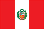
Flag description
three equal, vertical bands of red (hoist side), white, and red with the coat of arms centered in the white band; the coat of arms features a shield bearing a vicuna, cinchona tree (the source of quinine), and a yellow cornucopia spilling out gold coins, all framed by a green wreath Economy Peru
GDP - composition by sector
- agriculture
- 8.5%
- industry
- 26.4%
- services
- 53.1% (2006 est.)
GDP - per capita (PPP)
$6,400 (2006 est.)
GDP - real growth rate
6.5% (2006 est.)
GDP (official exchange rate)
$76.09 billion (2006 est.)
GDP (purchasing power parity)
$181.8 billion (2006 est.)
Geographic coordinates
10 00 S, 76 00 W
Geography - note
shares control of Lago Titicaca, world's highest navigable lake, with Bolivia; a remote slope of Nevado Mismi, a 5,316 m peak, is the ultimate source of the Amazon River People Peru
Government type
constitutional republic
Heliports
1 (2006)
HIV/AIDS - adult prevalence rate
0.5% (2003 est.)
HIV/AIDS - deaths
4,200 (2003 est.)
HIV/AIDS - people living with HIV/AIDS
82,000 (2003 est.)
Household income or consumption by percentage share
- highest 10%
- 37.2% (2000)
- lowest 10%
- 0.8%
IDPs
60,000 (civil war from 1980-2000; most IDPs are indigenous peasants in Andean and Amazonian regions) (2005)
Illicit drugs
until 1996 the world's largest coca leaf producer; cultivation of coca in Peru fell 15% to 31,150 hectares between 2002 and the end of 2003; much of the cocaine base is shipped to neighboring Colombia for processing into cocaine, while finished cocaine is shipped out from Pacific ports to the international drug market; increasing amounts of base and finished cocaine, however, are being moved to Brazil and Bolivia for use in the Southern Cone or transshipped to Europe and Africa This page was last updated on 8 February, 2007
Imports
$15.38 billion f.o.b. (2006 est.)
Imports - commodities
petroleum and petroleum products, plastics, machinery, vehicles, iron and steel, wheat, paper
Imports - partners
US 18.2%, China 8.5%, Brazil 8%, Ecuador 7.4%, Colombia 6.1%, Argentina 5.1%, Chile 5.1%, Venezuela 4.1% (2005)
Independence
28 July 1821 (from Spain)
Industrial production growth rate
7% (2006 est.)
Industries
mining and refining of minerals; steel, metal fabrication; petroleum extraction and refining, natural gas; fishing and fish processing, textiles, clothing, food processing
Infant mortality rate
- female
- 28.27 deaths/1,000 live births (2006 est.)
- male
- 33.49 deaths/1,000 live births
- total
- 30.94 deaths/1,000 live births
Inflation rate (consumer prices)
2.1% (2006 est.)
International organization participation
APEC, CAN, CSN, FAO, G-15, G-24, G-77, IADB, IAEA, IBRD, ICAO, ICC, ICCt, ICRM, IDA, IFAD, IFC, IFRCS, IHO, ILO, IMF, IMO, Interpol, IOC, IOM, IPU, ISO (correspondent), ITU, ITUC, LAES, LAIA, Mercosur (associate), MIGA, MINUSTAH, MONUC, NAM, OAS, OPANAL, OPCW, PCA, RG, UN, UN Security Council (temporary), UNCTAD, UNESCO, UNIDO, UNMEE, UNMIL, UNMIS, UNOCI, UNWTO, UPU, WCL, WCO, WFTU, WHO, WIPO, WMO, WTO
Internet country code
.pe
Internet hosts
269,981 (2006)
Internet Service Providers (ISPs)
10 (2000)
Internet users
4.6 million (2005) Transportation Peru
Investment (gross fixed)
20.3% of GDP (2006 est.)
Irrigated land
12,000 sq km (2003)
Judicial branch
Supreme Court of Justice or Corte Suprema de Justicia (judges are appointed by the National Council of the Judiciary)
Labor force
9.21 million (2006 est.)
Labor force - by occupation
- agriculture
- 9%
- industry
- 18%
- services
- 73% (2001)
Land boundaries
- border countries
- Bolivia 1,075 km, Brazil 2,995 km, Chile 171 km, Colombia 1,800 km, Ecuador 1,420 km
- total
- 7,461 km
Land use
- arable land
- 2.88%
- other
- 96.65% (2005)
- permanent crops
- 0.47%
Languages
Spanish (official), Quechua (official), Aymara, and a large number of minor Amazonian languages
Legal system
based on civil law system; accepts compulsory ICJ jurisdiction, with reservations
Legislative branch
- unicameral Congress of the Republic of Peru or Congreso de la Republica del Peru (120 seats; members are elected by popular vote to serve five-year terms)
- election results
- percent of vote by party - UPP 21.2%, PAP 20.6%, UN 15.3%, AF 13.1%, FC 7.1%, PP 4.1%, RN 4.0%; seats by party - UPP 45, PAP 36, UN 17, AF 13, FC 5, PP 2, RN 2
- elections
- last held 9 April 2006 (next to be held April 2011)
Life expectancy at birth
- female
- 71.71 years (2006 est.)
- male
- 68.05 years
- total population
- 69.84 years
Literacy
- definition
- age 15 and over can read and write
- female
- 82.1% (2004 est.) Government Peru
- male
- 93.5%
- total population
- 87.7%
Location
Western South America, bordering the South Pacific Ocean, between Chile and Ecuador
Manpower available for military service
- females age 18-49
- 6,544,408 (2005 est.)
- males age 18-49
- 6,647,874
Manpower fit for military service
- females age 18-49
- 5,278,511 (2005 est.)
- males age 18-49
- 4,938,417
Manpower reaching military service age annually
- females age 18-49
- 269,799 (2005 est.)
- males age 18-49
- 277,105
Map references
South America
Maritime claims
- continental shelf
- 200 nm
- territorial sea
- 200 nm
Median age
- female
- 25.5 years (2006 est.)
- male
- 25 years
- total
- 25.3 years
Merchant marine
- by type
- cargo 3, petroleum tanker 1
- foreign-owned
- 1 (US 1)
- registered in other countries
- 15 (Panama 15) (2006)
- total
- 4 ships (1000 GRT or over) 38,954 GRT/62,255 DWT
Military branches
Peruvian Army (Ejercito Peruano), Peruvian Navy (Marina de Guerra del Peru; includes naval air, naval infantry, and coast guard), Peruvian Air Force (Fuerza Aerea del Peru, FAP)
Military expenditures - dollar figure
$829.3 million (2003 est.)
Military expenditures - percent of GDP
1.4% (2003 est.) Transnational Issues Peru
Military service age and obligation
18 years of age for compulsory military service (1999)
National holiday
Independence Day, 28 July (1821)
Nationality
- adjective
- Peruvian
- noun
- Peruvian(s)
Natural gas - consumption
860 million cu m (2004 est.)
Natural gas - exports
0 cu m (2004 est.)
Natural gas - imports
0 cu m (2004 est.)
Natural gas - production
860 million cu m (2004 est.)
Natural gas - proved reserves
246.8 billion cu m (1 January 2005 est.)
Natural hazards
earthquakes, tsunamis, flooding, landslides, mild volcanic activity
Natural resources
copper, silver, gold, petroleum, timber, fish, iron ore, coal, phosphate, potash, hydropower, natural gas
Net migration rate
-1.01 migrant(s)/1,000 population (2006 est.)
Oil - consumption
156,000 bbl/day (2004 est.)
Oil - exports
49,000 bbl/day (2004 est.)
Oil - imports
NA bbl/day
Oil - production
120,000 bbl/day (2005 est.)
Oil - proved reserves
370 million bbl (2006 est.)
Pipelines
gas 983 km; gas/lpg 61 km; liquid natural gas 106 km; liquid petroleum gas 517 km; oil 1,754 km; refined products 13 km (2006)
Political parties and leaders
Alliance For Progress (Alianza Para El Progreso) [Cesar ACUNA Peralta]; Alliance For The Future (Alianza Por El Futuro) or AF - a coalition of pro-FUJIMORI parties including Cambio 90, Nueva Mayoria, and Si Cumple [Martha CHAVEZ Cossio]; Centrist Front (Frente Del Centro) or FC - a coalition of Accion Popular, Somos Peru, and Coordinadora Nacional de Independientes [Drago KISIC]; Independent Moralizing Front (Frente Independiente Moralizador) or FIM [Fernando OLIVERA Vega]; Nationalist Party Uniting Peru (Partido Nacionalista Uniendo al Peru) or UPP - a coalition of Union for Peru (UPP) and Peruvian Nationalist Party (PNP) [Ollanta HUMALA Tasso]; National Restoration (Restauracion Nacional) or RN [Humberto LAY Sun]; National Unity (Unidad Nacional) or UN [Lourdes FLORES Nano]; Peru Possible (Peru Posible) or PP [David WAISMAN]; Peruvian Aprista Party (Partido Aprista Peruano) or PAP - also referred to by its original name Alianza Popular Revolucionaria Americana or APRA [Alan GARCIA]
Political pressure groups and leaders
leftist guerrilla groups include Shining Path [Abimael GUZMAN Reynoso (imprisoned), Gabriel MACARIO (top leader at-large)]; Tupac Amaru Revolutionary Movement or MRTA [Victor POLAY (imprisoned), Hugo AVALLENEDA Valdez (top leader at-large)]
Population
28,302,603 (July 2006 est.)
Population below poverty line
54% (2003 est.)
Population growth rate
1.32% (2006 est.)
Ports and terminals
Callao, Iquitos, Matarani, Pucallpa, Yurimaguas; note - Iquitos, Pucallpa, and Yurimaguas are on the upper reaches of the Amazon and its tributaries Military Peru
Public debt
33.8% of GDP (2006 est.)
Radio broadcast stations
AM 472, FM 198, shortwave 189 (1999)
Radios
6.65 million (1997)
Railways
- narrow gauge
- 500 km 0.914-m gauge (2005)
- standard gauge
- 2,962 km 1.435-m gauge
- total
- 3,462 km
Religions
Roman Catholic 81%, Seventh Day Adventist 1.4%, other Christian 0.7%, other 0.6%, unspecified or none 16.3% (2003 est.)
Reserves of foreign exchange and gold
$17.04 billion (2006 est.)
Roadways
- paved
- 11,351 km (including 276 km of expressways)
- total
- 78,829 km
- unpaved
- 67,478 km (2004)
Sex ratio
- at birth
- 1.05 male(s)/female
- total population
- 1.01 male(s)/female (2006 est.)
- under 15 years
- 1.04 male(s)/female 15-64 years: 1.01 male(s)/female 65 years and over: 0.89 male(s)/female
Suffrage
18 years of age; universal and compulsory until the age of 70; note - for the first time in recent elections, members of the military and national police were eligible to vote in the 2006 elections
Telephone system
- domestic
- nationwide microwave radio relay system and a domestic satellite system with 12 earth stations
- general assessment
- adequate for most requirements
- international
- country code - 51; satellite earth stations - 2 Intelsat (Atlantic Ocean); Pan American submarine cable
Telephones - main lines in use
2,250,500 (2005)
Telephones - mobile cellular
5.583 million (2005)
Television broadcast stations
13 (plus 112 repeaters) (1997)
Televisions
3.06 million (1997)
Terrain
western coastal plain (costa), high and rugged Andes in center (sierra), eastern lowland jungle of Amazon Basin (selva)
Total fertility rate
2.51 children born/woman (2006 est.)
Trafficking in persons
- current situation
- Peru is primarily a source country for women and children trafficked internally for the purposes of sexual exploitation and forced domestic labor; most victims are girls and young women moved internally from rural to urban areas, or from city to city, and lured or coerced into prostitution in nightclubs, bars, and brothels; Peruvians have also been trafficked for sexual exploitation to Spain, Japan, the United States, and Venezuela; the government acknowledges that sex tourism occurs, particularly in the Amazon region of the country
- tier rating
- Tier 2 Watch List - Peru is placed on the Tier 2 Watch List for failure to show evidence of increasing efforts to eliminate trafficking in 2005
Unemployment rate
7.2% in metropolitan Lima; widespread underemployment (2006 est.)
Waterways
- 8,808 km
- note
- 8,600 km of navigable tributaries of Amazon system and 208 km of Lago Titicaca (2005)