1994 Edition
CIA World Factbook 1994 (Project Gutenberg)
Introduction
Administrative divisions
4 provinces, 1 territory*, and 1 capital territory**; Balochistan, Federally Administered Tribal Areas*, Islamabad Capital Territory**, North-West Frontier, Punjab, Sindh note: the Pakistani-administered portion of the disputed Jammu and Kashmir region includes Azad Kashmir and the Northern Areas
Agriculture
22% of GDP, over 50% of labor force; world's largest contiguous irrigation system; major crops - cotton, wheat, rice, sugarcane, fruits, vegetables; livestock products - milk, beef, mutton, eggs; self-sufficient in food grain
Airports
total: 110 usable: 104 with permanent-surface runways: 75 with runways over 3,659 m: 1 with runways 2,440-3,659 m: 30 with runways 1,220-2,439 m: 43
Area
total area: 803,940 sq km land area: 778,720 sq km comparative area: slightly less than twice the size of California
Birth rate
42.22 births/1,000 population (1994 est.)
Branches
Army, Navy, Air Force, Civil Armed Forces, National Guard, paramilitary/security forces
Budget
revenues: $9.4 billion expenditures: $10.9 billion, including capital expenditures of $3.1 billion (1993 est.)
Capital
Islamabad
Climate
mostly hot, dry desert; temperate in northwest; arctic in north
Coastline
1,046 km
Constitution
10 April 1973, suspended 5 July 1977 restored with amendments, 30 December 1985
Currency
1 Pakistani rupee (PRe) = 100 paisa
Death rate
12.38 deaths/1,000 population (1994 est.)
Defense expenditures
exchange rate conversion - $3.0 billion, 5.7% of GNP (FY93/94)
Digraph
PK
Diplomatic representation in US
chief of mission: Ambassador Maleeha LODHI chancery: 2315 Massachusetts Avenue NW, Washington, DC 20008 telephone: (202) 939-6205
Economic aid
recipient: US commitments, including Ex-Im (FY70-89), $4.5 billion; Western (non-US) countries, ODA and OOF bilateral commitments (1980-89), $91 billion; OPEC bilateral aid (1979-89), $2.3 billion; Communist countries (1970-89), $3.2 billion note: including Bangladesh prior to 1972
Electricity
capacity: 10,000,000 kW production: 43 billion kWh consumption per capita: 350 kWh (1992)
Environment
current issues: water pollution from untreated sewage, industrial wastes, and agricultural runoff; water scarcity; a majority of the population does not have access to safe drinking water; deforestation; soil erosion; desertification natural hazards: frequent earthquakes, occasionally severe especially in north and west; flooding along the Indus after heavy rains (July and August) international agreements: party to - Endangered Species, Environmental Modification, Nuclear Test Ban, Wetlands; signed, but not ratified - Biodiversity, Climate Change, Law of the Sea, Marine Life Conservation
Ethnic divisions
Punjabi, Sindhi, Pashtun (Pathan), Baloch, Muhajir (immigrants from India and their descendents)
Exchange rates
Pakistani rupees (PRs) per US$1 - 30.214 (January 1994), 28.107 (1993), 25.083 (1992), 23.801 (1991), 21.707 (1990), 20.541 (1989)
Executive branch
chief of state: President Sardar Farooq LEGHARI election last held on 13 November 1993 (next to be held no later than 14 October 1998); results - LEGHARI was elected by Parliament and the four provincial assemblies head of government: Prime Minister Benazir BHUTTO cabinet: Cabinet
Exports
$6.8 billion (f.o.b., FY92) commodities: cotton, textiles, clothing, rice, leather, carpets partners: US, Japan, Hong Kong, Germany, UK
External debt
$24 billion (1993 est.)
FAX
- (202) 387-0484 consulate(s) general: Los Angeles and New York
- [92] (51) 214222 consulate(s) general: Karachi, Lahore consulate(s): Peshawar
Fiscal year
1 July - 30 June
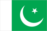
Flag
green with a vertical white band (symbolizing the role of religious minorities) on the hoist side; a large white crescent and star are centered in the green field; the crescent, star, and color green are traditional symbols of Islam
Highways
total: 110,677 km paved: 58,677 km unpaved: gravel 23,000 km; improved earth 29,000 km (1988)
Illicit drugs
major illicit producer of opium and hashish for the international drug trade; despite some success in reducing cultivation, remains world's fourth largest opium producer (140 metric tons in 1993)
Imports
$9.1 billion (f.o.b., FY92) commodities: petroleum, petroleum products, machinery, transportation equipment, vegetable oils, animal fats, chemicals partners: Japan, US, Germany, UK, Saudi Arabia
Independence
14 August 1947 (from UK)
Industrial production
growth rate 7.3% (FY92); accounts for 23% of GDP
Industries
textiles, food processing, beverages, construction materials, clothing, paper products, shrimp
Infant mortality rate
101.9 deaths/1,000 live births (1994 est.)
Inflation rate (consumer prices)
12.7% (FY91)
International disputes
status of Kashmir with India; border question with Afghanistan (Durand Line); water-sharing problems (Wular Barrage) over the Indus with upstream riparian India
Irrigated land
162,200 sq km (1989)
Judicial branch
Supreme Court, Federal Islamic (Shari'at) Court
Labor force
28.9 million by occupation: agriculture 54%, mining and manufacturing 13%, services 33%, extensive export of labor (1987 est.)
Land boundaries
total 6,774 km, Afghanistan 2,430 km, China 523 km, India 2,912 km, Iran 909 km
Land use
arable land: 26% permanent crops: 0% meadows and pastures: 6% forest and woodland: 4% other: 64%
Languages
Urdu (official), English (official; lingua franca of Pakistani elite and most government ministries), Punjabi 64%, Sindhi 12%, Pashtu 8%, Urdu 7%, Balochi and other 9%
Legal system
based on English common law with provisions to accommodate Pakistan's stature as an Islamic state; accepts compulsory ICJ jurisdiction, with reservations
Legislative branch
bicameral Parliament (Majlis-e-Shoora)
Life expectancy at birth
total population: 57.41 years male: 56.79 years female: 58.06 years (1994 est.)
Literacy
age 15 and over can read and write (1990 est.) total population: 35% male: 47% female: 21%
Location
Southern Asia, along the Arabian Sea, between India and Afghanistan
Manpower availability
males age 15-49 29,548,746; fit for military service 18,134,013; reach military age (17) annually 1,391,258 (1994 est.)
Map references
Asia, Standard Time Zones of the World
Maritime claims
contiguous zone: 24 nm continental shelf: 200 nm or the edge of continental margin exclusive economic zone: 200 nm territorial sea: 12 nm
Member of
AsDB, C, CCC, CP, ECO, ESCAP, FAO, G-19, G-24, G-77, GATT, IAEA, IBRD, ICAO, ICC, ICFTU, IDA, IDB, IFAD, IFC, ILO, IMF, IMO, INMARSAT, INTELSAT, INTERPOL, IOC, IOM, ISO, ITU, LORCS, MINURSO, NAM, OAS (observer), OIC, PCA, SAARC, UN, UNCTAD, UNESCO, UNHCR, UNIDO, UNIKOM, UNOSOM, UNTAC, UPU, WCL, WFTU, WHO, WIPO, WMO, WTO
Merchant marine
30 ships (1,000 GRT or over) totaling 352,189 GRT/532,782 DWT, bulk 1, cargo 25, oil tanker 1, passenger-cargo 3
Names
conventional long form: Islamic Republic of Pakistan conventional short form: Pakistan former: West Pakistan
National Assembly
elections last held 6 October 1993 (next to be held by October 1998); results - seats (217 total); Pakistan People's Party (PPP) 92; Pakistan Muslim League, Nawaz Sharif faction (PML/N) 75; Pakistan Muslim League, Junejo faction (PML/J) 6; Islami-Jamhoori-Mahaz (IJM-Islamic Democratic Front) 4; Awami National Party (ANP) 3; Pakhtun Khwa Milli Awami Party (PKMAP) 4; Pakistan Islamic Front (PIF) 3; Jamhoori Watan Party (JWP) 2; Mutaheda Deeni Mahaz (MDM) 2; Balochistan National Movement, Hayee Group (BNM/H) 1; Balochistan National Movement, Mengal Group (BNM/M) 1; National Democratic Alliance (NDA) 1; National People's Party (NPP) 1; Pakhtun Quami Party (PKQP) 1; Religious minorities 10 reserved seats; independents, 9; results pending, 2
National holiday
Pakistan Day, 23 March (1956) (proclamation of the republic)
National product
GNP - purchasing power equivalent - $239 billion (1993 est.)
National product per capita
$1,900 (1993 est.)
National product real growth rate
3% (FY93 est.)
Nationality
noun: Pakistani(s) adjective: Pakistani
Natural resources
land, extensive natural gas reserves, limited petroleum, poor quality coal, iron ore, copper, salt, limestone
Net migration rate
-1.21 migrant(s)/1,000 population (1994 est.)
Note
controls Khyber Pass and Bolan Pass, traditional invasion routes between Central Asia and the Indian Subcontinent
Other political or pressure groups
military remains important political force; ulema (clergy), landowners, industrialists, and small merchants also influential
Overview
Pakistan is a poor Third World country faced with the usual problems of rapidly increasing population, sizable government deficits, and heavy dependence on foreign aid. In addition, the economy must support a large military establishment. Rapid economic growth, averaging 5%-6% over the past decade has helped Pakistan cope with these problems. However, growth slumped to 3% in FY93 because of severe flooding, which damaged the key export crop, cotton. Almost all agriculture and small-scale industry is in private hands. In 1990, Pakistan embarked on a sweeping economic liberalization program to boost foreign and domestic private investment and lower foreign aid dependence. The SHARIF government denationalized several state-owned firms and attracted some foreign investment. Pakistan likely will have difficulty raising living standards because of its rapidly expanding population. At the current rate of growth, population would double in 25 years.
Pipelines
crude oil 250 km; petroleum products 885 km; natural gas 4,044 km (1987)
Political parties and leaders
government: Pakistan People's Party (PPP), Benazir BHUTTO; Pakistan Muslim League, Junejo faction (PML/J), Hamid Nasir CHATTHA; National People's Party (NPP), Ghulam Mustapha JATOI; Pakhtun Khwa Milli Awami Party (PKMAP), Mahmood Khan ACHAKZAI; Balochistan National Movement, Hayee Group (BNM/H), Dr. HAYEE Baluch; National Democratic Alliance (NDA), Maulana Kausar NIAZI; Pakhtun Quami Party (PKQP), Mohammed AFZAL Khan; Jamhoori Watan Party (JWP), Akbar Khan BUGTI opposition: Pakistan Muslim League, Nawaz Sharif faction (PML/N), Nawaz SHARIF; Awami National Party (ANP), Khan Abdul WALI KHAN; Pakistan Islamic Front (PIF), Qazi Hussain AHMED; Balochistan National Movement, Mengal Group (BNM/M), Sardar Akhtar MENGAL; Mohajir Quami Movement, Altaf faction (MQM/A); Jamaat-i-Islami (JI); Jamiat-al-Hadith (JAH) frequently shifting: Mutaheda Deeni Mahaz (MDM), Maulana Sami-ul-HAQ, the MDM includes Jamiat Ulema-i-Pakistan, Niazi faction (JUP/NI) and Anjuman Sepah-i-Sahaba Pakistan (ASSP); Islami-Jamhoori-Mahaz (IJM-Islamic Democratic Party), the IJM includes Jamiat Ulema-i-Islami, Fazlur Rehman group (JUI/F); Jamiat Ulema-i-Pakistan, Noorani faction (JUP/NO); Jamiat Ulema-i-Islam, Sami-ul-Haq faction (JUI/S); Pakistan Muslim League, Functional Group (PML/F); Pakistan National Party (PNP) note: most Pakistani political groups are motivated primarily by opportunism and political alliances can shift frequently
Population
128,855,965 (July 1994 est.)
Population growth rate
2.86% (1994 est.)
Ports
Gwadar, Karachi, Port Muhammad bin Qasim
Railroads
8,773 km total; 7,718 km broad gauge, 445 km 1-meter gauge, and 610 km less than 1-meter gauge; 1,037 km broad-gauge double track; 286 km electrified; all government owned (1985)
Religions
Muslim 97% (Sunni 77%, Shi'a 20%), Christian, Hindu, and other 3%
Senate
elections last held NA March 1994 (next to be held NA March 1997); results - seats (87 total) Pakistan People's Party (PPP) 22, Pakistan Muslim League, Nawaz Sharif faction (PML/N) 17; Tribal Area Representatives (nonparty) 8, Awami National Party (ANP) 6, Pakistan Muslim League, Junejo faction (PML/J) 5, Jamhoori Watan Party (JWP) 5, Mohajir Quami Movement, Altaf faction (MQM/A) 5, Jamiat Ulema-i-Islam, Fazlur Rehman group (JUI/F) 2, Pakhtun Khwa Milli Awami Party (PKMAP) 2, Jamaat-i-Islami (JI) 2, National People's Party (NPP) 2, Balochistan National Movement, Hayee Group (BNM/H) 1, Balochistan National Movement, Mengal Group (BNM/M) 1, Jamiat Ulema-i-Pakistan, Niazi faction (JUP/NI) 1, Jamiat Ulema-i-Pakistan, Noorani faction (JUP/NO) 1, Jamiat-al-Hadith (JAH) 1, Jamiat Ulema-i-Islam, Sami-ul-Haq faction (JUI/S) 1, Pakistan Muslim League, Functional Group (PML/F) 1, Pakistan National Party (PNP) 1, independents 2, vacant 1
Suffrage
21 years of age; universal; separate electorates and reserved parliamentary seats for non-Muslims
Telecommunications
the domestic telephone system is poor, adequate only for government and business use; about 7 telephones per 1,000 persons; the system for international traffic is better and employs both microwave radio relay and satellites; satellite ground stations - 1 Atlantic Ocean INTELSAT and 2 Indian Ocean INTELSAT; broadcast stations - 19 AM, 8 FM, 29 TV
Terrain
flat Indus plain in east; mountains in north and northwest; Balochistan plateau in west
Total fertility rate
6.43 children born/woman (1994 est.)
Type
republic
Unemployment rate
10% (FY91 est.)
US diplomatic representation
chief of mission: Ambassador John MONJO embassy: Diplomatic Enclave, Ramna 5, Islamabad mailing address: P. O. Box 1048, PSC 1212, Box 2000, Unit 6220,Islamabad or APO AE 09812-2000 telephone: [92] (51) 826161 through 79