2017 Edition
CIA World Factbook 2017 Archive (HTML)
Introduction
Background
The Polynesian Maori reached New Zealand in about A.D. 800. In 1840, their chieftains entered into a compact with Britain, the Treaty of Waitangi, in which they ceded sovereignty to Queen Victoria while retaining territorial rights. That same year, the British began the first organized colonial settlement. A series of land wars between 1843 and 1872 ended with the defeat of the native peoples. The British colony of New Zealand became an independent dominion in 1907 and supported the UK militarily in both world wars. New Zealand's full participation in a number of defense alliances lapsed by the 1980s. In recent years, the government has sought to address longstanding Maori grievances. New Zealand assumed a nonpermanent seat on the UN Security Council for the 2015-16 term.
Geography
Area
- 268,838 sq km 264,537 sq km 4,301 sq km includes Antipodes Islands, Auckland Islands, Bounty Islands, Campbell Island, Chatham Islands, and Kermadec Islands
- land
- 264,537 sq km
- note
- includes Antipodes Islands, Auckland Islands, Bounty Islands, Campbell Island, Chatham Islands, and Kermadec Islands
- total
- 268,838 sq km
- water
- 4,301 sq km
Area - comparative
almost twice the size of North Carolina; about the size of Colorado
Climate
temperate with sharp regional contrasts
Coastline
15,134 km
Elevation
- 388 m lowest point: Pacific Ocean 0 m highest point: Aoraki-Mount Cook 3,724 m
- elevation extremes
- lowest point: Pacific Ocean 0 m
- highest point
- Aoraki-Mount Cook 3,724 m
- mean elevation
- 388 m
Environment - current issues
deforestation; soil erosion; native flora and fauna hard-hit by invasive species
Environment - international agreements
- Antarctic-Environmental Protocol, Antarctic-Marine Living Resources, Antarctic Treaty, Biodiversity, Climate Change, Climate Change-Kyoto Protocol, Desertification, Endangered Species, Environmental Modification, Hazardous Wastes, Law of the Sea, Marine Dumping, Ozone Layer Protection, Ship Pollution, Tropical Timber 83, Tropical Timber 94, Wetlands, Whaling Antarctic Seals, Marine Life Conservation
- party to
- Antarctic-Environmental Protocol, Antarctic-Marine Living Resources, Antarctic Treaty, Biodiversity, Climate Change, Climate Change-Kyoto Protocol, Desertification, Endangered Species, Environmental Modification, Hazardous Wastes, Law of the Sea, Marine Dumping, Ozone Layer Protection, Ship Pollution, Tropical Timber 83, Tropical Timber 94, Wetlands, Whaling
- signed, but not ratified
- Antarctic Seals, Marine Life Conservation
Geographic coordinates
41 00 S, 174 00 E
Geography - note
consists of two main islands and a number of smaller islands; South Island, the larger main island, is the 12th largest island in the world and is divided along its length by the Southern Alps; North Island is the 14th largest island in the world and is not as mountainous, but it is marked by volcanism; almost 90% of the population lives in cities and over three-quarters on North Island; Wellington is the southernmost national capital in the world
Irrigated land
7,210 sq km (2012)
Land boundaries
0 km
Land use
- 43.2% arable land 1.8%; permanent crops 0.3%; permanent pasture 41.1% 31.4% 25.4% (2011 est.)
- agricultural land
- 43.2%
- forest
- 31.4%
- other
- 25.4% (2011 est.)
Location
Oceania, islands in the South Pacific Ocean, southeast of Australia
Map references
Oceania
Maritime claims
- 12 nm 24 nm 200 nm 200 nm or to the edge of the continental margin
- contiguous zone
- 24 nm
- continental shelf
- 200 nm or to the edge of the continental margin
- exclusive economic zone
- 200 nm
- territorial sea
- 12 nm
Natural hazards
- earthquakes are common, though usually not severe; volcanic activity significant volcanism on North Island; Ruapehu (2,797 m), which last erupted in 2007, has a history of large eruptions in the past century; Taranaki has the potential to produce dangerous avalanches and lahars; other historically active volcanoes include Okataina, Raoul Island, Tongariro, and White Island
- volcanism
- significant volcanism on North Island; Ruapehu (2,797 m), which last erupted in 2007, has a history of large eruptions in the past century; Taranaki has the potential to produce dangerous avalanches and lahars; other historically active volcanoes include Okataina, Raoul Island, Tongariro, and White Island
Natural resources
natural gas, iron ore, sand, coal, timber, hydropower, gold, limestone
Population - distribution
over three-quarters of New Zealanders, including the indigenous Maori, live on the North Island, primarily in urban areas
Terrain
predominately mountainous with large coastal plains
People and Society
Age structure
- 19.69% (male 454,982/female 432,877) 13.35% (male 309,707/female 292,586) 39.82% (male 900,374/female 895,615) 11.89% (male 261,097/female 275,151) 15.25% (male 318,089/female 369,849) (2017 est.)
- 0-14 years
- 19.69% (male 454,982/female 432,877)
- 15-24 years
- 13.35% (male 309,707/female 292,586)
- 25-54 years
- 39.82% (male 900,374/female 895,615)
- 55-64 years
- 11.89% (male 261,097/female 275,151)
- 65 years and over
- 15.25% (male 318,089/female 369,849) (2017 est.)
Birth rate
13.2 births/1,000 population (2017 est.)
Death rate
7.5 deaths/1,000 population (2017 est.)
Dependency ratios
- 52.9 30.5 22.4 4.5 (2015 est.)
- elderly dependency ratio
- 22.4
- potential support ratio
- 4.5 (2015 est.)
- total dependency ratio
- 52.9
- youth dependency ratio
- 30.5
Drinking water source
- urban: 100% of population rural: 100% of population total: 100% of population urban: 0% of population rural: 0% of population total: 0% of population (2015 est.)
- rural
- 0% of population
- total
- 0% of population (2015 est.)
- urban
- 0% of population
Education expenditures
6.3% of GDP (2014)
Ethnic groups
- European 71.2%, Maori 14.1%, Asian 11.3%, Pacific peoples 7.6%, Middle Eastern, Latin American, African 1.1%, other 1.6%, not stated or unidentified 5.4% based on the 2013 census of the usually resident population; percentages add up to more than 100% because respondents were able to identify more than one ethnic group (2013 est.)
- note
- based on the 2013 census of the usually resident population; percentages add up to more than 100% because respondents were able to identify more than one ethnic group (2013 est.)
Health expenditures
11% of GDP (2014)
HIV/AIDS - adult prevalence rate
NA
HIV/AIDS - deaths
NA
HIV/AIDS - people living with HIV/AIDS
NA
Hospital bed density
2.3 beds/1,000 population (2011)
Infant mortality rate
- 4.4 deaths/1,000 live births 4.9 deaths/1,000 live births 3.9 deaths/1,000 live births (2017 est.)
- female
- 3.9 deaths/1,000 live births (2017 est.)
- male
- 4.9 deaths/1,000 live births
- total
- 4.4 deaths/1,000 live births
Languages
- English (de facto official) 89.8%, Maori (de jure official) 3.5%, Samoan 2%, Hindi 1.6%, French 1.2%, Northern Chinese 1.2%, Yue 1%, other or not stated 20.5%, New Zealand Sign Language (de jure official) shares sum to 120.8% due to multiple responses on census (2013 est.)
- note
- shares sum to 120.8% due to multiple responses on census (2013 est.)
Life expectancy at birth
- 81.3 years 79.1 years 83.5 years (2017 est.)
- female
- 83.5 years (2017 est.)
- male
- 79.1 years
- total population
- 81.3 years
Major urban areas - population
Auckland 1.344 million; WELLINGTON (capital) 383,000 (2015)
Maternal mortality rate
11 deaths/100,000 live births (2015 est.)
Median age
- 37.9 years 37.1 years 38.8 years (2017 est.)
- female
- 38.8 years (2017 est.)
- male
- 37.1 years
- total
- 37.9 years
Mother's mean age at first birth
- 27.8 years median age at first birth (2009 est.)
- note
- median age at first birth (2009 est.)
Nationality
- New Zealander(s) New Zealand
- adjective
- New Zealand
- noun
- New Zealander(s)
Net migration rate
2.2 migrant(s)/1,000 population (2017 est.)
Obesity - adult prevalence rate
30.8% (2016)
Physicians density
2.85 physicians/1,000 population (2014)
Population
4,510,327 (July 2017 est.)
Population distribution
over three-quarters of New Zealanders, including the indigenous Maori, live on the North Island, primarily in urban areas
Population growth rate
0.79% (2017 est.)
Religions
- Christian 44.3% (Catholic 11.6%, Anglican 10.8%, Presbyterian and Congregational 7.8%, Methodist, 2.4%, Pentecostal 1.8%, other 9.9%), Hindu 2.1%, Buddhist 1.4%, Maori Christian 1.3%, Islam 1.1%, other religion 1.4% (includes Judaism, Spiritualism and New Age religions, Baha'i, Asian religions other than Buddhism), no religion 38.5%, not stated or unidentified 8.2%, objected to answering 4.1% based on the 2013 census of the usually resident population; percentages add up to more than 100% because respondents were able to identify more than one religion (2013 est.)
- note
- based on the 2013 census of the usually resident population; percentages add up to more than 100% because respondents were able to identify more than one religion (2013 est.)
School life expectancy (primary to tertiary education)
- 19 years 18 years 20 years (2014)
- female
- 20 years (2014)
- male
- 18 years
- total
- 19 years
Sex ratio
- 1.05 male(s)/female 1.05 male(s)/female 1.06 male(s)/female 1 male(s)/female 0.95 male(s)/female 0.86 male(s)/female 0.99 male(s)/female (2016 est.)
- 0-14 years
- 1.05 male(s)/female
- 15-24 years
- 1.06 male(s)/female
- 25-54 years
- 1 male(s)/female
- 55-64 years
- 0.95 male(s)/female
- 65 years and over
- 0.86 male(s)/female
- at birth
- 1.05 male(s)/female
- total population
- 0.99 male(s)/female (2016 est.)
Total fertility rate
2.02 children born/woman (2017 est.)
Unemployment, youth ages 15-24
- 13.2% 13.1% 13.4% (2016 est.)
- female
- 13.4% (2016 est.)
- male
- 13.1%
- total
- 13.2%
Urbanization
- 86.4% of total population (2017) 0.98% annual rate of change (2015-20 est.)
- rate of urbanization
- 0.98% annual rate of change (2015-20 est.)
- urban population
- 86.4% of total population (2017)
Government
Administrative divisions
16 regions and 1 territory*; Auckland, Bay of Plenty, Canterbury, Chatham Islands*, Gisborne, Hawke's Bay, Manawatu-Wanganui, Marlborough, Nelson, Northland, Otago, Southland, Taranaki, Tasman, Waikato, Wellington, West Coast
Capital
- Wellington 41 18 S, 174 47 E UTC+12 (17 hours ahead of Washington, DC, during Standard Time) +1hr, begins last Sunday in September; ends first Sunday in April New Zealand has two time zones - New Zealand standard time (12 hours in advance of UTC), and Chatham Islands time (45 minutes in advance of New Zealand standard time)
- daylight saving time
- +1hr, begins last Sunday in September; ends first Sunday in April
- geographic coordinates
- 41 18 S, 174 47 E
- name
- Wellington
- note
- New Zealand has two time zones - New Zealand standard time (12 hours in advance of UTC), and Chatham Islands time (45 minutes in advance of New Zealand standard time)
- time difference
- UTC+12 (17 hours ahead of Washington, DC, during Standard Time)
Citizenship
- no at least one parent must be a citizen of New Zealand yes 3 years
- citizenship by birth
- no
- citizenship by descent only
- at least one parent must be a citizen of New Zealand
- dual citizenship recognized
- yes
- residency requirement for naturalization
- 3 years
Constitution
Constitution Act 1986 (the principal formal charter) adopted and effective 1 January 1987; amended 1999, 2005, 2014 (2016)
Country name
- none New Zealand NZ Dutch explorer Abel TASMAN was the first European to reach New Zealand in 1642; he named it Staten Landt, but Dutch cartographers renamed it Nova Zeelandia in 1645 after the Dutch province of Zeeland; British explorer Captain James COOK subsequently anglicized the name to New Zealand when he mapped the islands in 1769
- abbreviation
- NZ
- conventional long form
- none
- conventional short form
- New Zealand
- etymology
- Dutch explorer Abel TASMAN was the first European to reach New Zealand in 1642; he named it Staten Landt, but Dutch cartographers renamed it Nova Zeelandia in 1645 after the Dutch province of Zeeland; British explorer Captain James COOK subsequently anglicized the name to New Zealand when he mapped the islands in 1769
Dependent areas
Cook Islands, Niue, Tokelau
Diplomatic representation from the US
- Ambassador Scott P. BROWN (since 27 June 2017) note - also accredited to Samoa 29 Fitzherbert Terrace, Thorndon, Wellington P. O. Box 1190, Wellington; PSC 467, Box 1, APO AP 96531-1034 [64] (4) 462-6000 [64] (4) 499-0490 Auckland
- chief of mission
- Ambassador Scott P. BROWN (since 27 June 2017) note - also accredited to Samoa
- consulate(s) general
- Auckland
- embassy
- 29 Fitzherbert Terrace, Thorndon, Wellington
- FAX
- [64] (4) 499-0490
- mailing address
- P. O. Box 1190, Wellington; PSC 467, Box 1, APO AP 96531-1034
- telephone
- [64] (4) 462-6000
Diplomatic representation in the US
- Ambassador Timothy John GROSER (since 28 January 2016) 37 Observatory Circle NW, Washington, DC 20008 [1] (202) 328-4800 [1] (202) 667-5227[1] (202) 667-5227 Honolulu (HI), Los Angeles, New York
- chancery
- 37 Observatory Circle NW, Washington, DC 20008
- chief of mission
- Ambassador Timothy John GROSER (since 28 January 2016)
- consulate(s) general
- Honolulu (HI), Los Angeles, New York
- FAX
- [1] (202) 667-5227[1] (202) 667-5227
- telephone
- [1] (202) 328-4800
Executive branch
- Queen ELIZABETH II (since 6 February 1952); represented by Governor General Dame Patricia Lee REDDY (since 28 September 2016) Prime Minister Jacinda ARDERN (since 26 October 2017); Deputy Prime Minister Winston PETERS (since 26 October 2017) Executive Council appointed by the governor general on the recommendation of the prime minister the monarchy is hereditary; governor general appointed by the monarch; following legislative elections, the leader of the majority party or majority coalition usually appointed prime minister by the governor general; deputy prime minister appointed by the governor general; note - Prime Minister ARDERN heads up a minority coalition government consisting of the Labor and New Zealand First parties with support from the Green Party
- cabinet
- Executive Council appointed by the governor general on the recommendation of the prime minister
- chief of state
- Queen ELIZABETH II (since 6 February 1952); represented by Governor General Dame Patricia Lee REDDY (since 28 September 2016)
- elections/appointments
- the monarchy is hereditary; governor general appointed by the monarch; following legislative elections, the leader of the majority party or majority coalition usually appointed prime minister by the governor general; deputy prime minister appointed by the governor general; note - Prime Minister ARDERN heads up a minority coalition government consisting of the Labor and New Zealand First parties with support from the Green Party
- head of government
- Prime Minister Jacinda ARDERN (since 26 October 2017); Deputy Prime Minister Winston PETERS (since 26 October 2017)
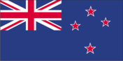
Flag description
blue with the flag of the UK in the upper hoist-side quadrant with four red five-pointed stars edged in white centered in the outer half of the flag; the stars represent the Southern Cross constellation
Government type
parliamentary democracy (New Zealand Parliament) under a constitutional monarchy; a Commonwealth realm
Independence
26 September 1907 (from the UK)
International law organization participation
accepts compulsory ICJ jurisdiction with reservations; accepts ICCt jurisdiction
International organization participation
ADB, ANZUS (US suspended security obligations to NZ on 11 August 1986), APEC, ARF, ASEAN (dialogue partner), Australia Group, BIS, C, CD, CP, EAS, EBRD, FAO, FATF, IAEA, IBRD, ICAO, ICC (national committees), ICCt, ICRM, IDA, IEA, IFAD, IFC, IFRCS, IHO, ILO, IMF, IMO, IMSO, Interpol, IOC, IOM, IPU, ISO, ITSO, ITU, ITUC (NGOs), MIGA, NSG, OECD, OPCW, Pacific Alliance (observer), Paris Club (associate), PCA, PIF, SICA (observer), Sparteca, SPC, UN, UNCTAD, UNESCO, UNHCR, UNIDO, UNMISS, UNTSO, UPU, WCO, WFTU (NGOs), WHO, WIPO, WMO, WTO
Judicial branch
- Supreme Court (consists of 5 justices including the chief justice); note - the Supreme Court in 2004 replaced the Judicial Committee of the Privy Council (in London) as the final appeals court justices appointed by the governor-general on the recommendation of the attorney-general; justices appointed for life Court of Appeal; High Court; tribunals and authorities; district courts; specialized courts for issues related to employment, environment, Maori lands, and military
- highest court(s)
- Supreme Court (consists of 5 justices including the chief justice); note - the Supreme Court in 2004 replaced the Judicial Committee of the Privy Council (in London) as the final appeals court
- judge selection and term of office
- justices appointed by the governor-general on the recommendation of the attorney-general; justices appointed for life
- subordinate courts
- Court of Appeal; High Court; tribunals and authorities; district courts; specialized courts for issues related to employment, environment, Maori lands, and military
Legal system
common law system, based on English model, with special legislation and land courts for the Maori
Legislative branch
- unicameral House of Representatives - commonly called Parliament (usually 120 seats; 70 members directly elected in single-seat constituencies, including 7 Maori constituencies, by simple majority vote and 50 directly elected by proportional representation vote; members serve 3-year terms) last held on 23 September 2017 (next to be held in September 2020) percent of vote by party - National Party 46%, Labor Party 35.9%, NZ First 7.5%, Green Party 5.9%, ACT Party .5%; seats by party - National Party 56, Labor Party 46, NZ First 9, Green Party 8, ACT Party 1
- description
- unicameral House of Representatives - commonly called Parliament (usually 120 seats; 70 members directly elected in single-seat constituencies, including 7 Maori constituencies, by simple majority vote and 50 directly elected by proportional representation vote; members serve 3-year terms)
- election results
- percent of vote by party - National Party 46%, Labor Party 35.9%, NZ First 7.5%, Green Party 5.9%, ACT Party .5%; seats by party - National Party 56, Labor Party 46, NZ First 9, Green Party 8, ACT Party 1
- elections
- last held on 23 September 2017 (next to be held in September 2020)
National anthem
- "God Defend New Zealand" Thomas BRACKEN [English], Thomas Henry SMITH [Maori]/John Joseph WOODS adopted 1940 as national song, adopted 1977 as co-national anthem; New Zealand has two national anthems with equal status; as a commonwealth realm, in addition to "God Defend New Zealand," "God Save the Queen" serves as a national anthem (see United Kingdom); "God Save the Queen" normally played only when a member of the royal family or the governor-general is present; in all other cases, "God Defend New Zealand" is played
- lyrics/music
- Thomas BRACKEN [English], Thomas Henry SMITH [Maori]/John Joseph WOODS
- name
- "God Defend New Zealand"
- note
- adopted 1940 as national song, adopted 1977 as co-national anthem; New Zealand has two national anthems with equal status; as a commonwealth realm, in addition to "God Defend New Zealand," "God Save the Queen" serves as a national anthem (see United Kingdom); "God Save the Queen" normally played only when a member of the royal family or the governor-general is present; in all other cases, "God Defend New Zealand" is played
National holiday
Waitangi Day (Treaty of Waitangi established British sovereignty over New Zealand), 6 February (1840); ANZAC Day (commemorated as the anniversary of the landing of troops of the Australian and New Zealand Army Corps during World War I at Gallipoli, Turkey), 25 April (1915)
National symbol(s)
- Southern Cross constellation (four, five-pointed stars), kiwi (bird), silver fern; national colors: black, white, red (ochre)
- Southern Cross constellation (four, five-pointed stars), kiwi (bird), silver fern; national colors
- black, white, red (ochre)
Political parties and leaders
ACT New Zealand [David SEYMOUR] Green Party [James SHAW] Mana Movement [Hone HARAWIRA] (formerly Mana Party) Maori Party [Marama FOX] New Zealand First Party or NZ First [Winston PETERS] New Zealand Labor Party [Jacinda ARDERN] New Zealand National Party [Bill ENGLISH] United Future New Zealand [Damian LIGHT]
Political pressure groups and leaders
- Women's Electoral Lobby or WEL apartheid groups; civil rights groups; farmers groups; Maori; nuclear weapons groups; women's rights groups
- other
- apartheid groups; civil rights groups; farmers groups; Maori; nuclear weapons groups; women's rights groups
Suffrage
18 years of age; universal
Economy
Agriculture - products
dairy products, sheep, beef, poultry, fruit, vegetables, wine, seafood, wheat and barley
Budget
- $68.45 billion $66.86 billion (2016 est.)
- expenditures
- $66.86 billion (2016 est.)
- revenues
- $68.45 billion
Budget surplus (+) or deficit (-)
0.9% of GDP (2016 est.)
Central bank discount rate
2.5% (31 December 2009) 5% (31 December 2008)
Commercial bank prime lending rate
5.02% (31 December 2016 est.) 5.76% (31 December 2015 est.)
Current account balance
$-5.013 billion (2016 est.) $-5.501 billion (2015 est.)
Debt - external
$84.03 billion (31 December 2016 est.) $86.15 billion (31 December 2015 est.)
Distribution of family income - Gini index
36.2 (1997)
Economy - overview
Over the past 40 years, the government has transformed New Zealand from an agrarian economy, dependent on concessionary British market access, to a more industrialized, free market economy that can compete globally. This dynamic growth has boosted real incomes, but left behind some at the bottom of the ladder and broadened and deepened the technological capabilities of the industrial sector. Per capita income rose for 10 consecutive years until 2007 in purchasing power parity terms, but fell in 2008-09. Debt-driven consumer spending drove robust growth in the first half of the decade, fueling a large balance of payments deficit that posed a challenge for policymakers. Inflationary pressures caused the central bank to raise its key rate steadily from January 2004 until it was among the highest in the OECD in 2007 and 2008. The higher rate attracted international capital inflows, which strengthened the currency and housing market while aggravating the current account deficit. Rising house prices, especially in Auckland, have become a political issue in recent years, as well as a policy challenge in 2016 and 2017, as the ability to afford housing has declined for many. The economy fell into recession before the start of the global financial crisis and contracted for five consecutive quarters in 2008 and 2009. In line with global peers, the central bank cut interest rates aggressively and the government developed fiscal stimulus measures. The economy pulled out of recession in 2009, and achieved 2%-3% growth from 2011 to 2016. Nevertheless, key trade sectors remain vulnerable to weak external demand and lower commodity prices. In the aftermath of the 2010 Canterbury earthquakes, the government has continued programs to expand export markets, develop capital markets, invest in innovation, raise productivity growth, and develop infrastructure, while easing its fiscal austerity. Expanding New Zealand’s network of free trade agreements remains a top foreign policy priority.
Exchange rates
New Zealand dollars (NZD) per US dollar - 1.4341 (2016 est.) 1.4341 (2015 est.) 1.4279 (2014 est.) 1.2039 (2013 est.) 1.23 (2012 est.)
Exports
$33.61 billion (2016 est.) $34.43 billion (2015 est.)
Exports - commodities
dairy products, meat and edible offal, logs and wood articles, fruit, crude oil, wine
Exports - partners
China 19.4%, Australia 17.1%, US 10.9%, Japan 6.2% (2016)
Fiscal year
- 1 April - 31 March this is the fiscal year for tax purposes
- note
- this is the fiscal year for tax purposes
GDP - composition, by end use
- 57.5% 18.5% 23.1% 0.1% 26.8% -26.1% (2016 est.)
- exports of goods and services
- 26.8%
- government consumption
- 18.5%
- household consumption
- 57.5%
- imports of goods and services
- -26.1% (2016 est.)
- investment in fixed capital
- 23.1%
- investment in inventories
- 0.1%
GDP - composition, by sector of origin
- 3.9% 26.3% 69.8% (2016 est.)
- agriculture
- 3.9%
- industry
- 26.3%
- services
- 69.8% (2016 est.)
GDP - per capita (PPP)
- $37,200 (2016 est.) $36,700 (2015 est.) $36,200 (2014 est.) data are in 2016 dollars
- note
- data are in 2016 dollars
GDP - real growth rate
3.6% (2016 est.) 3.2% (2015 est.) 2.8% (2014 est.)
GDP (official exchange rate)
$181.7 billion (2016 est.)
GDP (purchasing power parity)
- $176.4 billion (2016 est.) $168.2 billion (2015 est.) $161.2 billion (2014 est.) data are in 2016 dollars
- note
- data are in 2016 dollars
Gross national saving
20.5% of GDP (2016 est.) 20.1% of GDP (2015 est.) 19.5% of GDP (2014 est.)
Household income or consumption by percentage share
- NA% NA%
- highest 10%
- NA%
- lowest 10%
- NA%
Imports
$35.53 billion (2016 est.) $35.79 billion (2015 est.)
Imports - commodities
petroleum and products, mechanical machinery, vehicles and parts, electrical machinery, textiles
Imports - partners
China 19.9%, Australia 12.6%, US 11.3%, Japan 7.1%, Germany 4.8%, Thailand 4.5%, South Korea 4.2% (2016)
Industrial production growth rate
3.5% (2016 est.)
Industries
agriculture, forestry, fishing, logs and wood articles, manufacturing, mining, construction, financial services, real estate services, tourism
Inflation rate (consumer prices)
0.6% (2016 est.) 0.3% (2015 est.)
Labor force
2.598 million (2016 est.)
Labor force - by occupation
- 7% 19% 74% (2006 est.)
- agriculture
- 7%
- industry
- 19%
- services
- 74% (2006 est.)
Market value of publicly traded shares
$74.35 billion (31 December 2015 est.) $74.42 billion (31 December 2014 est.) $65.96 billion (31 December 2013 est.)
Population below poverty line
NA%
Public debt
33.3% of GDP (2016 est.) 34.8% of GDP (2015 est.)
Reserves of foreign exchange and gold
$17.81 billion (31 December 2016 est.) $14.7 billion (31 December 2015 est.)
Stock of broad money
$190 billion (31 December 2016 est.) $173.4 billion (31 December 2015 est.)
Stock of direct foreign investment - abroad
$59.08 billion (31 December 2009)
Stock of direct foreign investment - at home
$77.31 billion (31 December 2016 est.) $74.47 billion (31 December 2015 est.)
Stock of domestic credit
$284.7 billion (31 December 2016 est.) $261.3 billion (31 December 2015 est.)
Stock of narrow money
$42.01 billion (31 December 2016 est.) $37.67 billion (31 December 2015 est.)
Taxes and other revenues
37.6% of GDP (2016 est.)
Unemployment rate
5.1% (2016 est.) 5.4% (2015 est.)
Energy
Carbon dioxide emissions from consumption of energy
37 million Mt (2013 est.)
Crude oil - exports
30,560 bbl/day (2016 est.)
Crude oil - imports
109,200 bbl/day (2016 est.)
Crude oil - production
34,730 bbl/day (2016 est.)
Crude oil - proved reserves
56.9 million bbl (1 January 2017 es)
Electricity - consumption
39.93 billion kWh (2015 est.)
Electricity - exports
0 kWh (2016 est.)
Electricity - from fossil fuels
24% of total installed capacity (2015 est.)
Electricity - from hydroelectric plants
56.5% of total installed capacity (2015 est.)
Electricity - from nuclear fuels
0% of total installed capacity (2015 est.)
Electricity - from other renewable sources
19.7% of total installed capacity (2015 est.)
Electricity - imports
0 kWh (2016 est.)
Electricity - installed generating capacity
9.454 million kW (2015 est.)
Electricity - production
42.77 billion kWh (2015 est.)
Electricity access
- 100% (2016)
- electrification - total population
- 100% (2016)
Natural gas - consumption
9.08 billion cu m (2015 est.)
Natural gas - exports
0 cu m (2014 est.)
Natural gas - imports
0 cu m (2014 est.)
Natural gas - production
4.954 billion cu m (2015 est.)
Natural gas - proved reserves
35.88 billion cu m (1 January 2017 es)
Refined petroleum products - consumption
167,700 bbl/day (2016 est.)
Refined petroleum products - exports
3,863 bbl/day (2016 est.)
Refined petroleum products - imports
54,750 bbl/day (2016 est.)
Refined petroleum products - production
117,100 bbl/day (2016 est.)
Communications
Broadcast media
state-owned Television New Zealand operates multiple TV networks and state-owned Radio New Zealand operates 3 radio networks and an external shortwave radio service to the South Pacific region; a small number of national commercial TV and radio stations and many regional commercial television and radio stations are available; cable and satellite TV systems are available (2008)
Internet country code
.nz
Internet users
- 3,958,642 88.5% (July 2016 est.)
- percent of population
- 88.5% (July 2016 est.)
- total
- 3,958,642
Telephone system
- excellent domestic and international systems combined fixed-line and mobile-cellular telephone subscribership exceeds 170 per 100 persons country code - 64; the Southern Cross submarine cable system provides links to Australia, Fiji, and the US; satellite earth stations - 8 (1 Inmarsat - Pacific Ocean, 7 other) (2016)
- domestic
- combined fixed-line and mobile-cellular telephone subscribership exceeds 170 per 100 persons
- general assessment
- excellent domestic and international systems
- international
- country code - 64; the Southern Cross submarine cable system provides links to Australia, Fiji, and the US; satellite earth stations - 8 (1 Inmarsat - Pacific Ocean, 7 other) (2016)
Telephones - fixed lines
- 1.82 million 41 (July 2016 est.)
- subscriptions per 100 inhabitants
- 41 (July 2016 est.)
- total subscriptions
- 1.82 million
Telephones - mobile cellular
- 5.8 million 130 (July 2016 est.)
- subscriptions per 100 inhabitants
- 130 (July 2016 est.)
- total
- 5.8 million
Transportation
Airports
123 (2013)
Airports - with paved runways
- 1 (2017)
- 1,524 to 2,437 m
- 12
- 2,438 to 3,047 m
- 1
- 914 to 1,523 m
- 23
- over 3,047 m
- 2
- total
- 39
- under 914 m
- 1 (2017)
Airports - with unpaved runways
- 48 (2013)
- 1,524 to 2,437 m
- 3
- 914 to 1,523 m
- 33
- total
- 84
- under 914 m
- 48 (2013)
Civil aircraft registration country code prefix
ZK (2016)
Merchant marine
- bulk carrier 3, cargo 3, chemical tanker 1, container 1, passenger/cargo 5, petroleum tanker 2 7 (Germany 2, Hong Kong 1, South Africa 1, Switzerland 2, UK 1) 5 (Antigua and Barbuda 2, Cook Islands 2, Samoa 1) (2010)
- by type
- bulk carrier 3, cargo 3, chemical tanker 1, container 1, passenger/cargo 5, petroleum tanker 2
- foreign-owned
- 7 (Germany 2, Hong Kong 1, South Africa 1, Switzerland 2, UK 1)
- registered in other countries
- 5 (Antigua and Barbuda 2, Cook Islands 2, Samoa 1) (2010)
- total
- 15
National air transport system
- 15,304,409 999,384,961 mt-km (2015)
- annual freight traffic on registered air carriers
- 999,384,961 mt-km (2015)
- annual passenger traffic on registered air carriers
- 15,304,409
- inventory of registered aircraft operated by air carriers
- 123
- number of registered air carriers
- 6
Pipelines
condensate 331 km; gas 1,936 km; liquid petroleum gas 172 km; oil 288 km; refined products 198 km (2013)
Ports and terminals
- Auckland, Lyttelton, Manukau Harbor, Marsden Point, Tauranga, Wellington
- major seaport(s)
- Auckland, Lyttelton, Manukau Harbor, Marsden Point, Tauranga, Wellington
Railways
- 4,128 km 4,128 km 1.067-m gauge (503 km electrified) (2014)
- narrow gauge
- 4,128 km 1.067-m gauge (503 km electrified) (2014)
- total
- 4,128 km
Roadways
- 94,902 km 62,759 km (includes 199 km of expressways) 32,143 km (2012)
- paved
- 62,759 km (includes 199 km of expressways)
- total
- 94,902 km
- unpaved
- 32,143 km (2012)
Military and Security
Military branches
- New Zealand Defense Force (NZDF): New Zealand Army, Royal New Zealand Navy, Royal New Zealand Air Force (Te Hokowhitu o Kahurangi, RNZAF) (2013)
- New Zealand Defense Force (NZDF)
- New Zealand Army, Royal New Zealand Navy, Royal New Zealand Air Force (Te Hokowhitu o Kahurangi, RNZAF) (2013)
Military expenditures
1.13% of GDP (2016) 1.11% of GDP (2015) 1.13% of GDP (2014) 1.12% of GDP (2013) 1.19% of GDP (2012)
Military service age and obligation
17 years of age for voluntary military service; soldiers cannot be deployed until the age of 18; no conscription; 3 years of secondary education required; must be a citizen of NZ, the UK, Australia, Canada, or the US, and resident of NZ for the previous 5 years (2013)
Transnational Issues
Disputes - international
asserts a territorial claim in Antarctica (Ross Dependency)
Illicit drugs
significant consumer of amphetamines